U.S. Geological Survey, Alaska Science Center, 4210 University Drive, Anchorage, AK, 99508, USA.
Water and Environmental Research Center, University of Alaska Fairbanks, 467 Duckering Avenue, Fairbanks, AK, 99775, USA.
Ambio. 2017 Nov;46(7):769-786. doi: 10.1007/s13280-017-0915-9. Epub 2017 Mar 25.
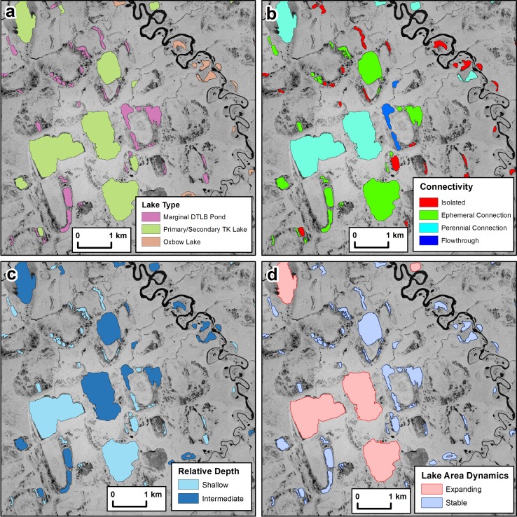
Lakes are dominant and diverse landscape features in the Arctic, but conventional land cover classification schemes typically map them as a single uniform class. Here, we present a detailed lake-centric geospatial database for an Arctic watershed in northern Alaska. We developed a GIS dataset consisting of 4362 lakes that provides information on lake morphometry, hydrologic connectivity, surface area dynamics, surrounding terrestrial ecotypes, and other important conditions describing Arctic lakes. Analyzing the geospatial database relative to fish and bird survey data shows relations to lake depth and hydrologic connectivity, which are being used to guide research and aid in the management of aquatic resources in the National Petroleum Reserve in Alaska. Further development of similar geospatial databases is needed to better understand and plan for the impacts of ongoing climate and land-use changes occurring across lake-rich landscapes in the Arctic.
湖泊是北极地区占主导地位且多种多样的景观特征,但传统的土地覆盖分类方案通常将其映射为单一的均匀类别。在这里,我们为阿拉斯加北部的一个北极流域提供了一个详细的以湖泊为中心的地理空间数据库。我们开发了一个 GIS 数据集,其中包含 4362 个湖泊,提供了有关湖泊形态、水文连通性、表面积动态、周围陆地生态型以及描述北极湖泊的其他重要条件的信息。对地理空间数据库与鱼类和鸟类调查数据进行分析表明,湖泊深度和水文连通性存在关系,这些关系正被用于指导研究和帮助管理阿拉斯加国家石油储备区的水生资源。需要进一步开发类似的地理空间数据库,以更好地了解和规划正在进行的气候和土地利用变化对北极富湖景观的影响。