• 文献检索
  • 文档翻译
  • 深度研究
  • 学术资讯
  • Suppr Zotero 插件Zotero 插件
  • 邀请有礼
  • 套餐&价格
  • 历史记录
应用&插件
Suppr Zotero 插件Zotero 插件浏览器插件Mac 客户端Windows 客户端微信小程序
定价
高级版会员购买积分包购买API积分包
服务
文献检索文档翻译深度研究API 文档MCP 服务
关于我们
关于 Suppr公司介绍联系我们用户协议隐私条款
关注我们

Suppr 超能文献

核心技术专利:CN118964589B侵权必究
粤ICP备2023148730 号-1Suppr @ 2026

文献检索

告别复杂PubMed语法,用中文像聊天一样搜索,搜遍4000万医学文献。AI智能推荐,让科研检索更轻松。

立即免费搜索

文件翻译

保留排版,准确专业,支持PDF/Word/PPT等文件格式,支持 12+语言互译。

免费翻译文档

深度研究

AI帮你快速写综述,25分钟生成高质量综述,智能提取关键信息,辅助科研写作。

立即免费体验

利用机载激光雷达数据,脉冲密度和格网单元大小对速生桉人工林地上碳预测与制图的联合效应

Combined effect of pulse density and grid cell size on predicting and mapping aboveground carbon in fast-growing Eucalyptus forest plantation using airborne LiDAR data.

作者信息

Silva Carlos Alberto, Hudak Andrew Thomas, Klauberg Carine, Vierling Lee Alexandre, Gonzalez-Benecke Carlos, de Padua Chaves Carvalho Samuel, Rodriguez Luiz Carlos Estraviz, Cardil Adrián

机构信息

Department of Natural Resources and Society, College of Natural Resources, University of Idaho, (UI), 875 Perimeter Drive, Moscow, ID, 83843, USA.

US Forest Service (USDA), Rocky Mountain Research Station, RMRS, 1221 South Main Street, Moscow, ID, 83843, USA.

出版信息

Carbon Balance Manag. 2017 Dec;12(1):13. doi: 10.1186/s13021-017-0081-1. Epub 2017 Jun 7.

DOI:10.1186/s13021-017-0081-1
PMID:28593558
原文链接:https://pmc.ncbi.nlm.nih.gov/articles/PMC5462670/
Abstract

BACKGROUND

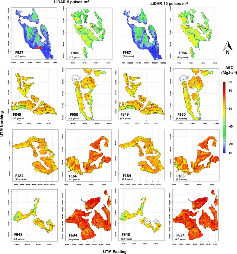
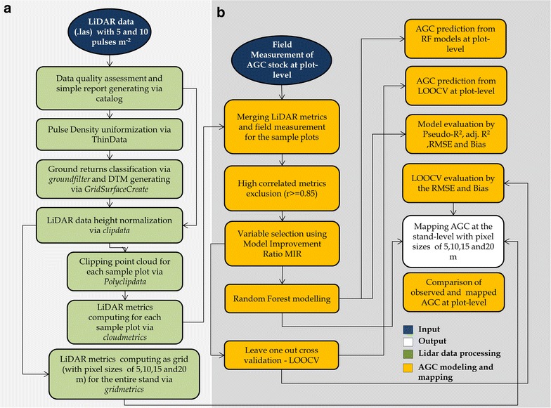
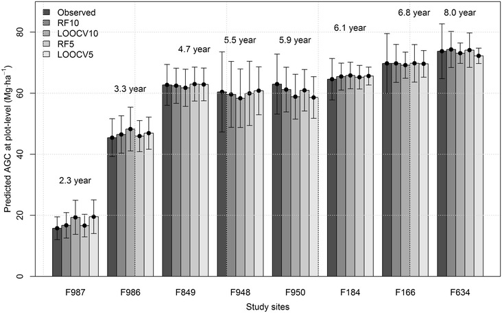
LiDAR remote sensing is a rapidly evolving technology for quantifying a variety of forest attributes, including aboveground carbon (AGC). Pulse density influences the acquisition cost of LiDAR, and grid cell size influences AGC prediction using plot-based methods; however, little work has evaluated the effects of LiDAR pulse density and cell size for predicting and mapping AGC in fast-growing Eucalyptus forest plantations. The aim of this study was to evaluate the effect of LiDAR pulse density and grid cell size on AGC prediction accuracy at plot and stand-levels using airborne LiDAR and field data. We used the Random Forest (RF) machine learning algorithm to model AGC using LiDAR-derived metrics from LiDAR collections of 5 and 10 pulses m (RF5 and RF10) and grid cell sizes of 5, 10, 15 and 20 m.

RESULTS

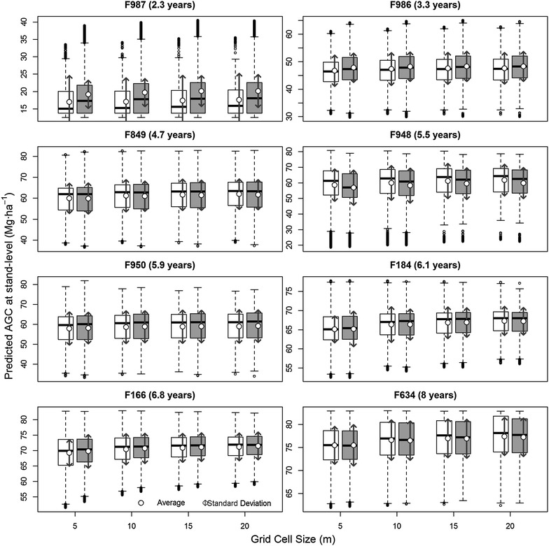
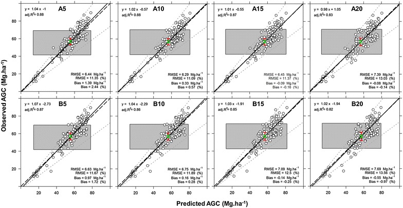
The results show that LiDAR pulse density of 5 pulses m provides metrics with similar prediction accuracy for AGC as when using a dataset with 10 pulses m in these fast-growing plantations. Relative root mean square errors (RMSEs) for the RF5 and RF10 were 6.14 and 6.01%, respectively. Equivalence tests showed that the predicted AGC from the training and validation models were equivalent to the observed AGC measurements. The grid cell sizes for mapping ranging from 5 to 20 also did not significantly affect the prediction accuracy of AGC at stand level in this system.

CONCLUSION

LiDAR measurements can be used to predict and map AGC across variable-age Eucalyptus plantations with adequate levels of precision and accuracy using 5 pulses m and a grid cell size of 5 m. The promising results for AGC modeling in this study will allow for greater confidence in comparing AGC estimates with varying LiDAR sampling densities for Eucalyptus plantations and assist in decision making towards more cost effective and efficient forest inventory.

摘要

背景

激光雷达遥感是一种快速发展的技术,可用于量化包括地上碳(AGC)在内的各种森林属性。脉冲密度会影响激光雷达的采集成本,而网格单元大小会影响基于样地方法的AGC预测;然而,很少有研究评估激光雷达脉冲密度和单元大小对快速生长的桉树林人工林中AGC预测和制图的影响。本研究的目的是利用机载激光雷达和实地数据,评估激光雷达脉冲密度和网格单元大小对样地和林分水平上AGC预测精度的影响。我们使用随机森林(RF)机器学习算法,利用来自5脉冲/m和10脉冲/m的激光雷达数据(RF5和RF10)以及5、10、15和20米的网格单元大小,对AGC进行建模。

结果

结果表明,在这些快速生长的人工林中,5脉冲/m的激光雷达脉冲密度提供的AGC预测精度指标与使用10脉冲/m数据集时相似。RF5和RF10的相对均方根误差(RMSE)分别为6.14%和6.01%。等效性检验表明,训练模型和验证模型预测的AGC与观测到的AGC测量值等效。在该系统中,5至20米的制图网格单元大小也未显著影响林分水平上AGC的预测精度。

结论

使用5脉冲/m和5米的网格单元大小,激光雷达测量可用于以足够的精度预测和绘制不同年龄的桉树林人工林中的AGC。本研究中AGC建模的良好结果将使人们更有信心比较不同激光雷达采样密度下桉树林人工林的AGC估计值,并有助于做出更具成本效益和效率的森林清查决策。

https://cdn.ncbi.nlm.nih.gov/pmc/blobs/fa6d/5462670/6e2fe39bcfc0/13021_2017_81_Fig8_HTML.jpg
https://cdn.ncbi.nlm.nih.gov/pmc/blobs/fa6d/5462670/1867f458df2e/13021_2017_81_Fig1_HTML.jpg
https://cdn.ncbi.nlm.nih.gov/pmc/blobs/fa6d/5462670/cbeca170b865/13021_2017_81_Fig2_HTML.jpg
https://cdn.ncbi.nlm.nih.gov/pmc/blobs/fa6d/5462670/3cdd45c81c82/13021_2017_81_Fig3_HTML.jpg
https://cdn.ncbi.nlm.nih.gov/pmc/blobs/fa6d/5462670/e64272665a9f/13021_2017_81_Fig4_HTML.jpg
https://cdn.ncbi.nlm.nih.gov/pmc/blobs/fa6d/5462670/d42cc7a30eaf/13021_2017_81_Fig5_HTML.jpg
https://cdn.ncbi.nlm.nih.gov/pmc/blobs/fa6d/5462670/f57c2e1928e7/13021_2017_81_Fig6_HTML.jpg
https://cdn.ncbi.nlm.nih.gov/pmc/blobs/fa6d/5462670/41342b92e348/13021_2017_81_Fig7_HTML.jpg
https://cdn.ncbi.nlm.nih.gov/pmc/blobs/fa6d/5462670/6e2fe39bcfc0/13021_2017_81_Fig8_HTML.jpg

相似文献

1
Combined effect of pulse density and grid cell size on predicting and mapping aboveground carbon in fast-growing Eucalyptus forest plantation using airborne LiDAR data.利用机载激光雷达数据,脉冲密度和格网单元大小对速生桉人工林地上碳预测与制图的联合效应
Carbon Balance Manag. 2017 Dec;12(1):13. doi: 10.1186/s13021-017-0081-1. Epub 2017 Jun 7.
2
Erratum to: Combined effect of pulse density and grid cell size on predicting and mapping aboveground carbon in fast-growing Eucalyptus forest plantation using airborne LiDAR data.《利用机载激光雷达数据预测和绘制速生桉人工林地上碳储量时脉冲密度和格网单元大小的综合效应》勘误
Carbon Balance Manag. 2017 Dec;12(1):14. doi: 10.1186/s13021-017-0082-0. Epub 2017 Jun 30.
3
Scaling wood volume estimates from inventory plots to landscapes with airborne LiDAR in temperate deciduous forest.利用机载激光雷达将温带落叶林清查样地的木材体积估计值扩展到景观尺度。
Carbon Balance Manag. 2016 May 31;11(1):7. doi: 10.1186/s13021-016-0048-7. eCollection 2016 Dec.
4
Airborne lidar-based estimates of tropical forest structure in complex terrain: opportunities and trade-offs for REDD+.基于机载激光雷达的复杂地形中热带森林结构估计:减少毁林和森林退化所致排放量(REDD+)的机遇与权衡
Carbon Balance Manag. 2015 Feb 3;10(1):3. doi: 10.1186/s13021-015-0013-x. eCollection 2015 Dec.
5
Estimating Stand Height and Tree Density in Pinus taeda plantations using in-situ data, airborne LiDAR and k-Nearest Neighbor Imputation.利用现场数据、机载激光雷达和k近邻插补法估算火炬松人工林的林分高度和树木密度。
An Acad Bras Cienc. 2018 Jan-Mar;90(1):295-309. doi: 10.1590/0001-3765201820160071.
6
Modeling and mapping basal area of Pinus taeda L. plantation using airborne LiDAR data.利用机载激光雷达数据对火炬松人工林的断面积进行建模与制图。
An Acad Bras Cienc. 2017 Jul-Sep;89(3):1895-1905. doi: 10.1590/0001-3765201720160324. Epub 2017 Aug 14.
7
Impact of data model and point density on aboveground forest biomass estimation from airborne LiDAR.数据模型和点密度对机载激光雷达估算森林地上生物量的影响。
Carbon Balance Manag. 2017 Dec;12(1):4. doi: 10.1186/s13021-017-0073-1. Epub 2017 Feb 15.
8
A universal airborne LiDAR approach for tropical forest carbon mapping.一种用于热带森林碳测绘的通用机载激光雷达方法。
Oecologia. 2012 Apr;168(4):1147-60. doi: 10.1007/s00442-011-2165-z. Epub 2011 Oct 28.
9
Landsat-based spatiotemporal estimation of subtropical forest aboveground carbon storage using machine learning algorithms with hyperparameter tuning.基于陆地卫星数据,利用带超参数调优的机器学习算法对亚热带森林地上碳储量进行时空估计。
Front Plant Sci. 2024 Aug 29;15:1421567. doi: 10.3389/fpls.2024.1421567. eCollection 2024.
10
Estimation of forest aboveground biomass and uncertainties by integration of field measurements, airborne LiDAR, and SAR and optical satellite data in Mexico.通过整合实地测量、机载激光雷达、合成孔径雷达以及光学卫星数据估算墨西哥森林地上生物量及其不确定性
Carbon Balance Manag. 2018 Feb 21;13(1):5. doi: 10.1186/s13021-018-0093-5.

引用本文的文献

1
Prediction of Biomass and N Fixation of Legume-Grass Mixtures Using Sensor Fusion.利用传感器融合预测豆科植物与禾本科植物混合物的生物量和固氮量
Front Plant Sci. 2021 Jan 21;11:603921. doi: 10.3389/fpls.2020.603921. eCollection 2020.
2
Erratum to: Combined effect of pulse density and grid cell size on predicting and mapping aboveground carbon in fast-growing Eucalyptus forest plantation using airborne LiDAR data.《利用机载激光雷达数据预测和绘制速生桉人工林地上碳储量时脉冲密度和格网单元大小的综合效应》勘误
Carbon Balance Manag. 2017 Dec;12(1):14. doi: 10.1186/s13021-017-0082-0. Epub 2017 Jun 30.

本文引用的文献

1
Airborne lidar-based estimates of tropical forest structure in complex terrain: opportunities and trade-offs for REDD+.基于机载激光雷达的复杂地形中热带森林结构估计:减少毁林和森林退化所致排放量(REDD+)的机遇与权衡
Carbon Balance Manag. 2015 Feb 3;10(1):3. doi: 10.1186/s13021-015-0013-x. eCollection 2015 Dec.
2
Carbon sequestration: managing forests in uncertain times.碳固存:在不确定的时代管理森林。
Nature. 2014 Feb 13;506(7487):153-5. doi: 10.1038/506153a.
3
Using climate-FVS to project landscape-level forest carbon stores for 100 years from field and LiDAR measures of initial conditions.
利用气候-FVS 从实地和 LiDAR 初始条件测量数据中预测未来 100 年的景观水平森林碳储量。
Carbon Balance Manag. 2014 Feb 4;9(1):1. doi: 10.1186/1750-0680-9-1.
4
A regression-based equivalence test for model validation: shifting the burden of proof.用于模型验证的基于回归的等效性检验:转移举证责任。
Tree Physiol. 2005 Jul;25(7):903-13. doi: 10.1093/treephys/25.7.903.
5
A large terrestrial carbon sink in north america implied by atmospheric and oceanic carbon dioxide data and models.大气和海洋二氧化碳数据及模型显示北美存在一个巨大的陆地碳汇。
Science. 1998 Oct 16;282(5388):442-6. doi: 10.1126/science.282.5388.442.