Akros, 5 Reedbuck Road, Lusaka, Zambia.
University of Montana School of Public and Community Health Sciences, Missoula, MT, USA.
Malar J. 2018 Feb 23;17(1):93. doi: 10.1186/s12936-018-2236-2.
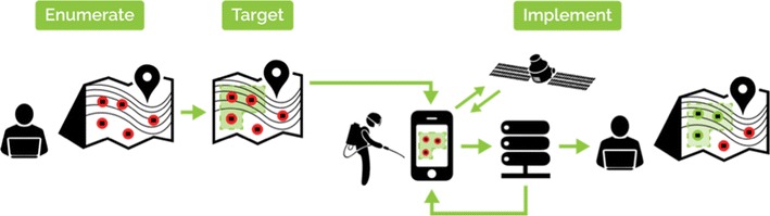
Indoor residual spraying (IRS) is a key tool in the fight to control, eliminate and ultimately eradicate malaria. IRS protection is based on a communal effect such that an individual's protection primarily relies on the community-level coverage of IRS with limited protection being provided by household-level coverage. To ensure a communal effect is achieved through IRS, achieving high and uniform community-level coverage should be the ultimate priority of an IRS campaign. Ensuring high community-level coverage of IRS in malaria-endemic areas is challenging given the lack of information available about both the location and number of households needing IRS in any given area. A process termed 'mSpray' has been developed and implemented and involves use of satellite imagery for enumeration for planning IRS and a mobile application to guide IRS implementation. This study assessed (1) the accuracy of the satellite enumeration and (2) how various degrees of spatial aid provided through the mSpray process affected community-level IRS coverage during the 2015 spray campaign in Zambia.
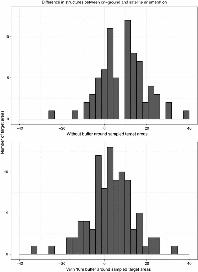
A 2-stage sampling process was applied to assess accuracy of satellite enumeration to determine number and location of sprayable structures. Results indicated an overall sensitivity of 94% for satellite enumeration compared to finding structures on the ground.
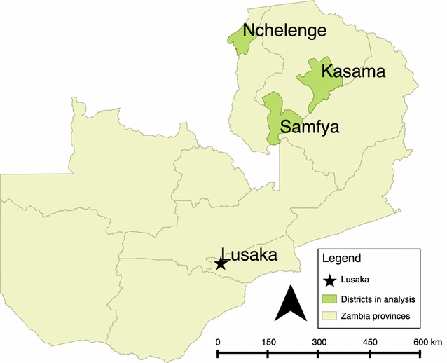
After adjusting for structure size, roof, and wall type, households in Nchelenge District where all types of satellite-based spatial aids (paper-based maps plus use of the mobile mSpray application) were used were more likely to have received IRS than Kasama district where maps used were not based on satellite enumeration. The probability of a household being sprayed in Nchelenge district where tablet-based maps were used, did not differ statistically from that of a household in Samfya District, where detailed paper-based spatial aids based on satellite enumeration were provided.
IRS coverage from the 2015 spray season benefited from the use of spatial aids based upon satellite enumeration. These spatial aids can guide costly IRS planning and implementation leading to attainment of higher spatial coverage, and likely improve disease impact.
室内滞留喷洒(IRS)是控制、消除和最终消灭疟疾的重要工具。IRS 保护基于群体效应,即个体的保护主要依赖于社区层面的 IRS 覆盖率,家庭层面的覆盖率提供的保护有限。为了通过 IRS 实现群体效应,IRS 运动的最终优先事项应该是实现高而均匀的社区层面覆盖率。考虑到在任何给定地区,IRS 所需的家庭数量和位置都缺乏信息,确保疟疾流行地区的 IRS 实现高社区层面覆盖率具有挑战性。已经开发并实施了一种称为“mSpray”的方法,该方法涉及使用卫星图像进行IRS 规划的计数以及使用移动应用程序来指导 IRS 的实施。本研究评估了(1)卫星计数的准确性,以及(2)在 2015 年赞比亚喷雾运动期间,通过 mSpray 过程提供的各种程度的空间辅助如何影响社区层面的 IRS 覆盖率。
采用两阶段抽样过程来评估卫星计数的准确性,以确定可喷洒结构的数量和位置。结果表明,与在地面上找到结构相比,卫星计数的总体敏感性为 94%。
在调整了结构大小、屋顶和墙壁类型后,在使用所有类型的基于卫星的空间辅助工具(纸质地图加使用移动 mSpray 应用程序)的恩切伦格区,家庭接受 IRS 的可能性高于不使用基于卫星计数的地图的卡萨马区。在使用基于平板电脑的地图的恩切伦格区,家庭接受 IRS 的可能性与在详细的基于卫星计数的纸质空间辅助工具的萨姆菲亚区的家庭没有统计学上的差异。
2015 年喷雾季节的 IRS 覆盖率受益于基于卫星计数的空间辅助工具的使用。这些空间辅助工具可以指导昂贵的 IRS 规划和实施,从而实现更高的空间覆盖率,并可能改善疾病的影响。