Kapwata Thandi, Manda Samuel
Environment and Health Research Unit, South African Medical Research Council, Johannesburg, South Africa.
Biostatistics Research Unit, South African Medical Research Council, Pretoria, South Africa.
BMC Health Serv Res. 2018 Mar 22;18(1):197. doi: 10.1186/s12913-018-3006-0.
Noncommunicable diseases (NCDs) including cardiovascular diseases (CVDs), diabetes, cancer and chronic lung disease are increasingly emerging as major contributors to morbidity and mortality in developing countries. For example, in South Africa, 195 people died per day between 1997 and 2004 from CVDs related causes. Access to efficient and effective health facility and care is an important contributing factor to overall population health and addressing prognosis, care and management CVD disease burden. This study aimed to spatially evaluate geographic health care access of people diagnosed with CVD to health facilities and to evaluate the density of the existing health facility network in South Africa.
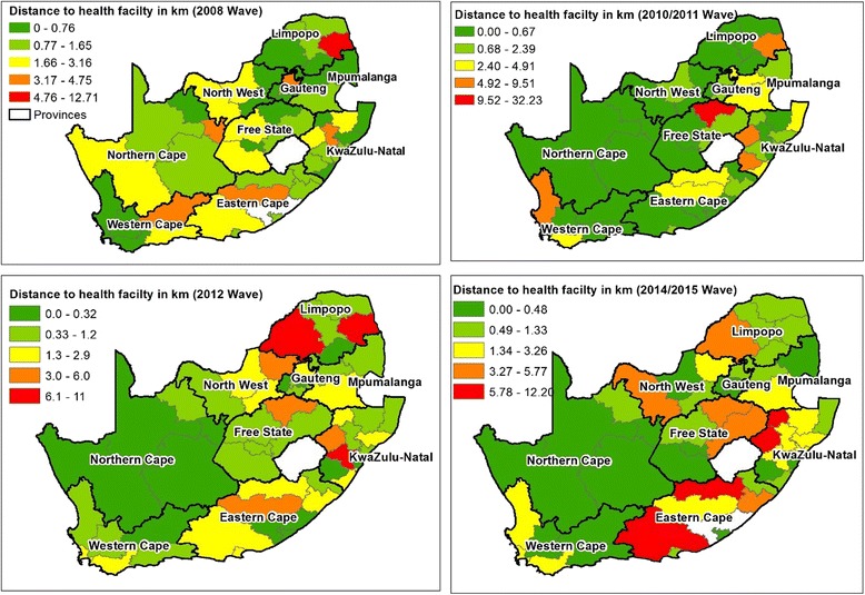
Data was obtained from the National Income Dynamics Study (NIDS) conducted in 4 waves (phases) between 2008 and 2014. The participants who responded as having heart problems that were diagnosed by a health practitioner were extracted for use in this study. Network analyst in ArcGIS ® was used to generate a least-cost path, which refers to the best path that one can travel. The residential locations of participants diagnosed with heart problems were put into the network analysis model as origins and the location of health facilities were destinations. District averages were used to protect the identity of studied participants.
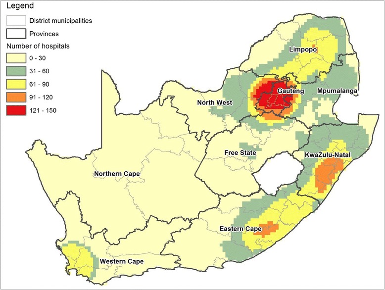
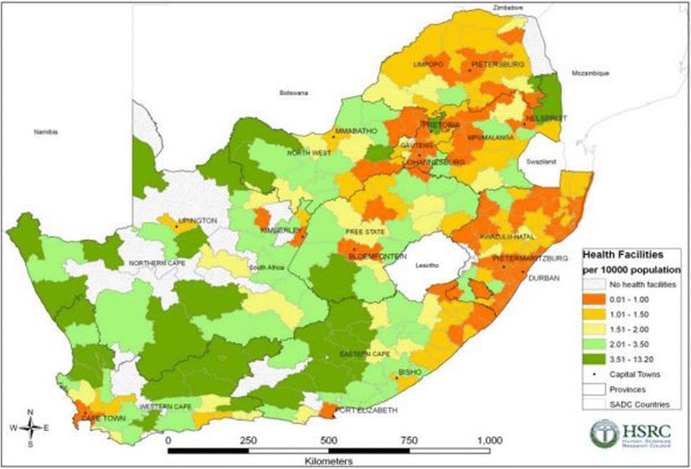
There were a total of 51, 42, 43, 43 health districts out the 52 that had recorded subjects with a heart condition in the 2008, 2010-2011, 2012 and 2014-2015 waves, respectively. The mean distance from a case household to a health facility per wave was 2, 2.3, 2.1 and 2.1 km in 2008, 2010-2011 and 2014-2015 respectively. The maximum individual distances travelled per wave were 41.4 km, 40,5 km, 44,2 km and 39.6 km for the 2008, 2010-2011, 2012 and 2014-2015 waves respectively. For district level analysis, participants with CVD residing in the districts found to be among the poorest in the country travelled the longest distances. These were located in the provinces of Limpopo and KwaZulu Natal. It was also found that districts with large proportions of their population living in rural settings had among the lowest densities of health facilities. Significant percentages of study participants were exposed to numerous CVD risk factors, the commonly reported one being high blood pressure. A lack of regular exercise was also commonly reported in each of the waves.
A lack of accessible healthcare in already impoverished municipalities could result in an increase lack of timely diagnosis, CVD case management. This could result in increased CVD-related morbidity and mortality. GIS methods have the potential to assist national health programs to develop policies that target issues such as areas or populations being underserved by health facilities and populations that must travel long distances to receive healthcare. These policies will be key in preventing and controlling the emerging CVD burden through an accessible primary healthcare system for early detection and case management.
包括心血管疾病(CVD)、糖尿病、癌症和慢性肺病在内的非传染性疾病日益成为发展中国家发病和死亡的主要原因。例如,在南非,1997年至2004年间,每天有195人死于心血管疾病相关原因。获得高效且有效的医疗设施和护理是影响总体人口健康以及解决心血管疾病负担的预后、护理和管理问题的一个重要因素。本研究旨在从空间上评估被诊断患有心血管疾病的人群获得医疗设施的地理可及性,并评估南非现有医疗设施网络的密度。
数据取自2008年至2014年间分4轮(阶段)开展的国民收入动态研究(NIDS)。抽取那些回复称有经医疗从业者诊断出的心脏问题的参与者用于本研究。使用ArcGIS®中的网络分析工具生成一条成本最低路径,即人们能够通行的最佳路径。将被诊断患有心脏问题的参与者的居住地点作为起点输入网络分析模型,将医疗设施的位置作为终点。采用地区平均值以保护研究参与者的身份。
在2008年、2010 - 2011年、2012年以及2014 - 2015年各轮调查中,在记录有心脏病患者的52个卫生区中,分别有51个、42个、43个和43个卫生区。2008年、2010 - 2011年以及2014 - 2015年各轮调查中,每户病例到医疗设施的平均距离分别为2公里、2.3公里、2.1公里和2.1公里。2008年、2010 - 2011年、2012年以及2014 - 2015年各轮调查中,个人出行的最大距离分别为41.4公里、40.5公里、44.2公里和39.6公里。对于地区层面的分析,居住在该国最贫困地区的心血管疾病患者出行距离最长。这些地区位于林波波省和夸祖鲁 - 纳塔尔省。还发现,农村人口比例大的地区医疗设施密度最低。相当比例的研究参与者暴露于多种心血管疾病风险因素,最常报告的是高血压。每一轮调查中普遍还报告缺乏定期锻炼的情况。
在本就贫困的城市地区缺乏可及的医疗保健可能导致缺乏及时诊断和心血管疾病病例管理的情况加剧。这可能导致心血管疾病相关的发病率和死亡率上升。地理信息系统方法有潜力协助国家卫生项目制定政策,以针对诸如医疗设施服务不足的地区或人群以及必须长途跋涉才能获得医疗保健的人群等问题。这些政策对于通过可及的初级卫生保健系统进行早期检测和病例管理来预防和控制新出现的心血管疾病负担至关重要。