• 文献检索
  • 文档翻译
  • 深度研究
  • 学术资讯
  • Suppr Zotero 插件Zotero 插件
  • 邀请有礼
  • 套餐&价格
  • 历史记录
应用&插件
Suppr Zotero 插件Zotero 插件浏览器插件Mac 客户端Windows 客户端微信小程序
定价
高级版会员购买积分包购买API积分包
服务
文献检索文档翻译深度研究API 文档MCP 服务
关于我们
关于 Suppr公司介绍联系我们用户协议隐私条款
关注我们

Suppr 超能文献

核心技术专利:CN118964589B侵权必究
粤ICP备2023148730 号-1Suppr @ 2026

文献检索

告别复杂PubMed语法,用中文像聊天一样搜索,搜遍4000万医学文献。AI智能推荐,让科研检索更轻松。

立即免费搜索

文件翻译

保留排版,准确专业,支持PDF/Word/PPT等文件格式,支持 12+语言互译。

免费翻译文档

深度研究

AI帮你快速写综述,25分钟生成高质量综述,智能提取关键信息,辅助科研写作。

立即免费体验

激光扫描点云配准:综述。

Registration of Laser Scanning Point Clouds: A Review.

机构信息

Jiangsu Provincial Key Laboratory of Geographic Information Science and Technology, Nanjing University, Nanjing 210093, China.

Collaborative Innovation Center for the South Sea Studies, Nanjing University, Nanjing 210093, China.

出版信息

Sensors (Basel). 2018 May 21;18(5):1641. doi: 10.3390/s18051641.

DOI:10.3390/s18051641
PMID:29883397
原文链接:https://pmc.ncbi.nlm.nih.gov/articles/PMC5981425/
Abstract

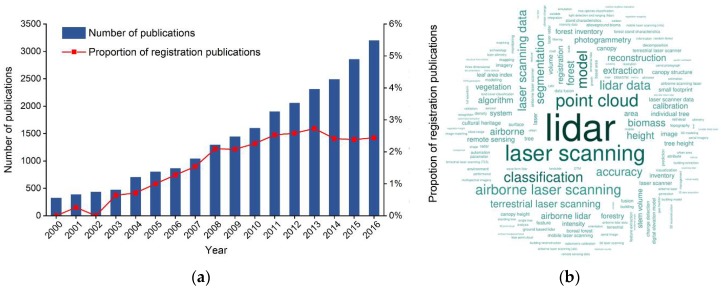
The integration of multi-platform, multi-angle, and multi-temporal LiDAR data has become important for geospatial data applications. This paper presents a comprehensive review of LiDAR data registration in the fields of photogrammetry and remote sensing. At present, a coarse-to-fine registration strategy is commonly used for LiDAR point clouds registration. The coarse registration method is first used to achieve a good initial position, based on which registration is then refined utilizing the fine registration method. According to the coarse-to-fine framework, this paper reviews current registration methods and their methodologies, and identifies important differences between them. The lack of standard data and unified evaluation systems is identified as a factor limiting objective comparison of different methods. The paper also describes the most commonly-used point cloud registration error analysis methods. Finally, avenues for future work on LiDAR data registration in terms of applications, data, and technology are discussed. In particular, there is a need to address registration of multi-angle and multi-scale data from various newly available types of LiDAR hardware, which will play an important role in diverse applications such as forest resource surveys, urban energy use, cultural heritage protection, and unmanned vehicles.

摘要

多平台、多角度和多时相的激光雷达数据的集成已成为地理空间数据应用的重要手段。本文对摄影测量和遥感领域的激光雷达数据配准进行了全面的回顾。目前,激光雷达点云配准通常采用粗-精配准策略。首先使用粗配准方法实现良好的初始位置,然后基于此使用精配准方法进行配准。根据粗-精框架,本文回顾了当前的配准方法及其方法,并确定了它们之间的重要区别。缺乏标准数据和统一的评估系统被认为是限制不同方法进行客观比较的一个因素。本文还描述了最常用的点云配准误差分析方法。最后,讨论了激光雷达数据配准在应用、数据和技术方面的未来工作方向。特别是需要解决来自各种新型激光雷达硬件的多角度和多尺度数据的配准问题,这将在森林资源调查、城市能源利用、文化遗产保护和无人驾驶车辆等各种应用中发挥重要作用。

https://cdn.ncbi.nlm.nih.gov/pmc/blobs/8c3c/5981425/dd8b159b498e/sensors-18-01641-g003.jpg
https://cdn.ncbi.nlm.nih.gov/pmc/blobs/8c3c/5981425/bf32c78fdfcc/sensors-18-01641-g001.jpg
https://cdn.ncbi.nlm.nih.gov/pmc/blobs/8c3c/5981425/b9c371dc6c9e/sensors-18-01641-g002.jpg
https://cdn.ncbi.nlm.nih.gov/pmc/blobs/8c3c/5981425/dd8b159b498e/sensors-18-01641-g003.jpg
https://cdn.ncbi.nlm.nih.gov/pmc/blobs/8c3c/5981425/bf32c78fdfcc/sensors-18-01641-g001.jpg
https://cdn.ncbi.nlm.nih.gov/pmc/blobs/8c3c/5981425/b9c371dc6c9e/sensors-18-01641-g002.jpg
https://cdn.ncbi.nlm.nih.gov/pmc/blobs/8c3c/5981425/dd8b159b498e/sensors-18-01641-g003.jpg

相似文献

1
Registration of Laser Scanning Point Clouds: A Review.激光扫描点云配准:综述。
Sensors (Basel). 2018 May 21;18(5):1641. doi: 10.3390/s18051641.
2
Automatic Registration of TLS-TLS and TLS-MLS Point Clouds Using a Genetic Algorithm.使用遗传算法对TLS-TLS和TLS-MLS点云进行自动配准
Sensors (Basel). 2017 Aug 29;17(9):1979. doi: 10.3390/s17091979.
3
Multi-level height maps-based registration method for sparse LiDAR point clouds in an urban scene.基于多级高度图的城市场景中稀疏激光雷达点云配准方法
Appl Opt. 2021 May 10;60(14):4154-4164. doi: 10.1364/AO.419746.
4
PLIN: A Network for Pseudo-LiDAR Point Cloud Interpolation.PLIN:用于伪激光雷达点云插值的网络。
Sensors (Basel). 2020 Mar 12;20(6):1573. doi: 10.3390/s20061573.
5
Registration of optical imagery and LiDAR data using an inherent geometrical constraint.利用固有几何约束对光学图像和激光雷达数据进行配准。
Opt Express. 2015 Mar 23;23(6):7694-702. doi: 10.1364/OE.23.007694.
6
Coarse Alignment Methodology of Point Cloud Based on Camera Position/Orientation Estimation Model.基于相机位置/方向估计模型的点云粗对齐方法
J Imaging. 2023 Dec 14;9(12):279. doi: 10.3390/jimaging9120279.
7
Automatic Registration of Optical Images with Airborne LiDAR Point Cloud in Urban Scenes Based on Line-Point Similarity Invariant and Extended Collinearity Equations.基于线-点相似不变量和扩展共线方程的城市场景中机载 LiDAR 点云与光学图像的自动配准
Sensors (Basel). 2019 Mar 3;19(5):1086. doi: 10.3390/s19051086.
8
Line-Based Registration of Panoramic Images and LiDAR Point Clouds for Mobile Mapping.用于移动测绘的全景图像与激光雷达点云的基于线的配准
Sensors (Basel). 2016 Dec 31;17(1):70. doi: 10.3390/s17010070.
9
Considerations for Achieving Cross-Platform Point Cloud Data Fusion across Different Dryland Ecosystem Structural States.实现跨不同旱地生态系统结构状态的跨平台点云数据融合的考量因素。
Front Plant Sci. 2018 Jan 10;8:2144. doi: 10.3389/fpls.2017.02144. eCollection 2017.
10
3D Point Cloud Recognition Based on a Multi-View Convolutional Neural Network.基于多视角卷积神经网络的三维点云识别。
Sensors (Basel). 2018 Oct 29;18(11):3681. doi: 10.3390/s18113681.

引用本文的文献

1
Spaceborne LiDAR Systems: Evolution, Capabilities, and Challenges.星载激光雷达系统:发展、能力与挑战。
Sensors (Basel). 2025 Jun 12;25(12):3696. doi: 10.3390/s25123696.
2
Three-Dimensional Point Cloud Applications, Datasets, and Compression Methodologies for Remote Sensing: A Meta-Survey.用于遥感的三维点云应用、数据集和压缩方法:一项元调查
Sensors (Basel). 2025 Mar 7;25(6):1660. doi: 10.3390/s25061660.
3
A Method to Evaluate Orientation-Dependent Errors in the Center of Contrast Targets Used with Terrestrial Laser Scanners.

本文引用的文献

1
3D Object Recognition in Cluttered Scenes with Local Surface Features: A Survey.基于局部表面特征的杂乱场景三维目标识别:综述
IEEE Trans Pattern Anal Mach Intell. 2014 Nov;36(11):2270-87. doi: 10.1109/TPAMI.2014.2316828.
2
Greenland ice sheet mass balance: a review.格陵兰冰原物质平衡:综述。
Rep Prog Phys. 2015 Apr;78(4):046801. doi: 10.1088/0034-4885/78/4/046801. Epub 2015 Mar 26.
3
Registration of 3D point clouds and meshes: a survey from rigid to nonrigid.三维点云和网格配准:从刚体到非刚体的综述。
一种评估地面激光扫描仪使用的对比度目标中心方向相关误差的方法。
Sensors (Basel). 2025 Jan 16;25(2):505. doi: 10.3390/s25020505.
4
Massive Point Cloud Processing for Efficient Construction Quality Inspection and Control.用于高效施工质量检测与控制的大规模点云处理
Sensors (Basel). 2024 Oct 23;24(21):6806. doi: 10.3390/s24216806.
5
Analytical Formalism for Data Representation and Object Detection with 2D LiDAR: Application in Mobile Robotics.用于二维激光雷达数据表示和目标检测的分析形式主义:在移动机器人中的应用
Sensors (Basel). 2024 Apr 3;24(7):2284. doi: 10.3390/s24072284.
6
Comparison of Point Cloud Registration Techniques on Scanned Physical Objects.扫描实物上点云配准技术的比较
Sensors (Basel). 2024 Mar 27;24(7):2142. doi: 10.3390/s24072142.
7
A review of rigid point cloud registration based on deep learning.基于深度学习的刚性点云配准综述。
Front Neurorobot. 2024 Jan 4;17:1281332. doi: 10.3389/fnbot.2023.1281332. eCollection 2023.
8
Automated Point Cloud Registration Approach Optimized for a Stop-and-Go Scanning System.针对走走停停扫描系统优化的自动点云配准方法。
Sensors (Basel). 2023 Dec 26;24(1):138. doi: 10.3390/s24010138.
9
Automatic Multiview Alignment of RGB-D Range Maps of Upper Limb Anatomy.自动多视角上肢解剖 RGB-D 范围图配准。
Sensors (Basel). 2023 Sep 12;23(18):7841. doi: 10.3390/s23187841.
10
MInet: A Novel Network Model for Point Cloud Processing by Integrating Multi-Modal Information.MInet:一种通过整合多模态信息进行点云处理的新型网络模型。
Sensors (Basel). 2023 Jul 12;23(14):6327. doi: 10.3390/s23146327.
IEEE Trans Vis Comput Graph. 2013 Jul;19(7):1199-217. doi: 10.1109/TVCG.2012.310.
4
Automatic Registration of Terrestrial Laser Scanning Point Clouds using Panoramic Reflectance Images.基于全景反射图像的地面激光扫描点云自动配准
Sensors (Basel). 2009;9(4):2621-46. doi: 10.3390/s90402621. Epub 2009 Apr 15.
5
Medical image registration: a review.医学图像配准:综述
Comput Methods Biomech Biomed Engin. 2014;17(2):73-93. doi: 10.1080/10255842.2012.670855. Epub 2012 Mar 22.
6
Convergent iterative closest-point algorithm to accomodate anisotropic and inhomogenous localization error.用于适应各向异性和不均匀定位误差的收敛迭代最近点算法。
IEEE Trans Pattern Anal Mach Intell. 2012 Aug;34(8):1520-32. doi: 10.1109/TPAMI.2011.248.
7
Searching for intellectual turning points: progressive knowledge domain visualization.寻找知识转折点:渐进式知识领域可视化
Proc Natl Acad Sci U S A. 2004 Apr 6;101 Suppl 1(Suppl 1):5303-10. doi: 10.1073/pnas.0307513100. Epub 2004 Jan 14.