Liu Haojie, Liao Kang, Lin Chunyu, Zhao Yao, Liu Meiqin
Beijing Key Laboratory of Advanced Information Science and Network, Institute of Information Science, Beijing Jiaotong University, Beijing 100044, China.
Sensors (Basel). 2020 Mar 12;20(6):1573. doi: 10.3390/s20061573.
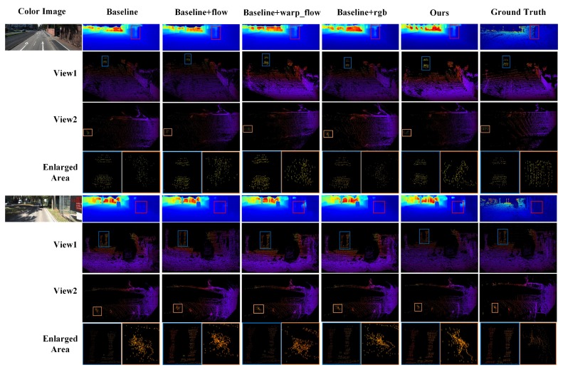
LiDAR sensors can provide dependable 3D spatial information at a low frequency (around 10 Hz) and have been widely applied in the field of autonomous driving and unmanned aerial vehicle (UAV). However, the camera with a higher frequency (around 20 Hz) has to be decreased so as to match with LiDAR in a multi-sensor system. In this paper, we propose a novel Pseudo-LiDAR interpolation network (PLIN) to increase the frequency of LiDAR sensor data. PLIN can generate temporally and spatially high-quality point cloud sequences to match the high frequency of cameras. To achieve this goal, we design a coarse interpolation stage guided by consecutive sparse depth maps and motion relationship. We also propose a refined interpolation stage guided by the realistic scene. Using this coarse-to-fine cascade structure, our method can progressively perceive multi-modal information and generate accurate intermediate point clouds. To the best of our knowledge, this is the first deep framework for Pseudo-LiDAR point cloud interpolation, which shows appealing applications in navigation systems equipped with LiDAR and cameras. Experimental results demonstrate that PLIN achieves promising performance on the KITTI dataset, significantly outperforming the traditional interpolation method and the state-of-the-art video interpolation technique.
激光雷达传感器能够以低频(约10赫兹)提供可靠的三维空间信息,并且已在自动驾驶和无人机(UAV)领域得到广泛应用。然而,在多传感器系统中,为了与激光雷达匹配,高频(约20赫兹)的摄像头帧率必须降低。在本文中,我们提出了一种新颖的伪激光雷达插值网络(PLIN),以提高激光雷达传感器数据的频率。PLIN能够生成时空上高质量的点云序列,以匹配摄像头的高频。为实现这一目标,我们设计了一个由连续稀疏深度图和运动关系引导的粗插值阶段。我们还提出了一个由真实场景引导的精细插值阶段。通过这种从粗到精的级联结构,我们的方法能够逐步感知多模态信息并生成精确的中间点云。据我们所知,这是首个用于伪激光雷达点云插值的深度框架,在配备激光雷达和摄像头的导航系统中显示出诱人的应用前景。实验结果表明,PLIN在KITTI数据集上取得了良好的性能,显著优于传统插值方法和当前最先进的视频插值技术。