• 文献检索
  • 文档翻译
  • 深度研究
  • 学术资讯
  • Suppr Zotero 插件Zotero 插件
  • 邀请有礼
  • 套餐&价格
  • 历史记录
应用&插件
Suppr Zotero 插件Zotero 插件浏览器插件Mac 客户端Windows 客户端微信小程序
定价
高级版会员购买积分包购买API积分包
服务
文献检索文档翻译深度研究API 文档MCP 服务
关于我们
关于 Suppr公司介绍联系我们用户协议隐私条款
关注我们

Suppr 超能文献

核心技术专利:CN118964589B侵权必究
粤ICP备2023148730 号-1Suppr @ 2026

文献检索

告别复杂PubMed语法,用中文像聊天一样搜索,搜遍4000万医学文献。AI智能推荐,让科研检索更轻松。

立即免费搜索

文件翻译

保留排版,准确专业,支持PDF/Word/PPT等文件格式,支持 12+语言互译。

免费翻译文档

深度研究

AI帮你快速写综述,25分钟生成高质量综述,智能提取关键信息,辅助科研写作。

立即免费体验

MInet:一种通过整合多模态信息进行点云处理的新型网络模型。

MInet: A Novel Network Model for Point Cloud Processing by Integrating Multi-Modal Information.

作者信息

Wang Yuhao, Zuo Yong, Du Zhihua, Song Xiaohan, Luo Tian, Hong Xiaobin, Wu Jian

机构信息

School of Electronic Engineering, Beijing University of Post and Telecommunications, Beijing 100876, China.

出版信息

Sensors (Basel). 2023 Jul 12;23(14):6327. doi: 10.3390/s23146327.

DOI:10.3390/s23146327
PMID:37514622
原文链接:https://pmc.ncbi.nlm.nih.gov/articles/PMC10386742/
Abstract

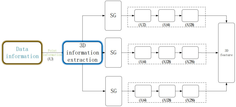
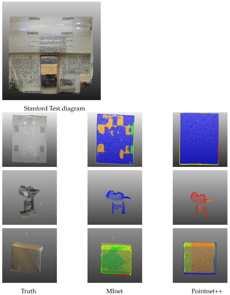
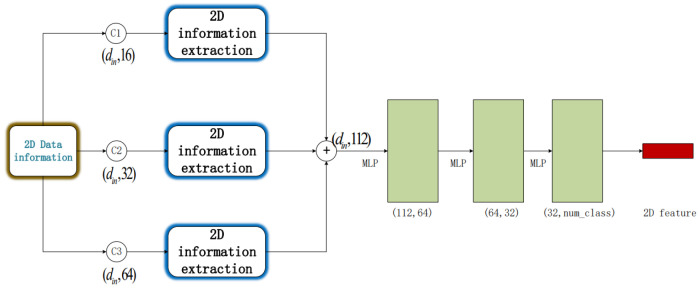
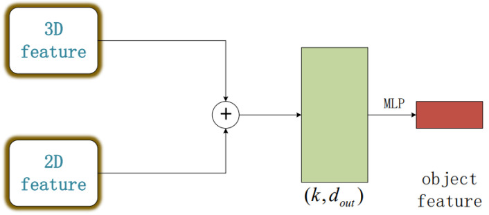
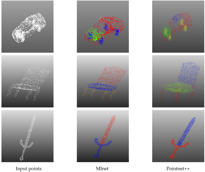
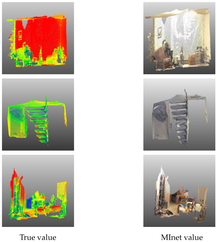
Three-dimensional LiDAR systems that capture point cloud data enable the simultaneous acquisition of spatial geometry and multi-wavelength intensity information, thereby paving the way for three-dimensional point cloud recognition and processing. However, due to the irregular distribution, low resolution of point clouds, and limited spatial recognition accuracy in complex environments, inherent errors occur in classifying and segmenting the acquired target information. Conversely, two-dimensional visible light images provide real-color information, enabling the distinction of object contours and fine details, thus yielding clear, high-resolution images when desired. The integration of two-dimensional information with point clouds offers complementary advantages. In this paper, we present the incorporation of two-dimensional information to form a multi-modal representation. From this, we extract local features to establish three-dimensional geometric relationships and two-dimensional color relationships. We introduce a novel network model, termed MInet (Multi-Information net), which effectively captures features relating to both two-dimensional color and three-dimensional pose information. This enhanced network model improves feature saliency, thereby facilitating superior segmentation and recognition tasks. We evaluate our MInet architecture using the ShapeNet and ThreeDMatch datasets for point cloud segmentation, and the Stanford dataset for object recognition. The robust results, coupled with quantitative and qualitative experiments, demonstrate the superior performance of our proposed method in point cloud segmentation and object recognition tasks.

摘要

能够捕获点云数据的三维激光雷达系统可同时获取空间几何信息和多波长强度信息,从而为三维点云识别与处理铺平道路。然而,由于点云分布不规则、分辨率低以及在复杂环境中空间识别精度有限,在对获取的目标信息进行分类和分割时会出现固有误差。相反,二维可见光图像提供真实颜色信息,能够区分物体轮廓和精细细节,从而在需要时生成清晰、高分辨率的图像。将二维信息与点云相结合具有互补优势。在本文中,我们展示了将二维信息合并以形成多模态表示。由此,我们提取局部特征以建立三维几何关系和二维颜色关系。我们引入了一种新颖的网络模型,称为MInet(多信息网络),它能有效捕获与二维颜色和三维姿态信息相关的特征。这种增强的网络模型提高了特征显著性,从而有助于完成更出色的分割和识别任务。我们使用ShapeNet和ThreeDMatch数据集进行点云分割,并使用斯坦福数据集进行目标识别来评估我们的MInet架构。稳健的结果以及定量和定性实验表明,我们提出的方法在点云分割和目标识别任务中具有卓越性能。

https://cdn.ncbi.nlm.nih.gov/pmc/blobs/00f8/10386742/f3be39f2a6d8/sensors-23-06327-g007.jpg
https://cdn.ncbi.nlm.nih.gov/pmc/blobs/00f8/10386742/ec9f39843dac/sensors-23-06327-g001.jpg
https://cdn.ncbi.nlm.nih.gov/pmc/blobs/00f8/10386742/7be203996ff0/sensors-23-06327-g002.jpg
https://cdn.ncbi.nlm.nih.gov/pmc/blobs/00f8/10386742/33db658fa16e/sensors-23-06327-g003.jpg
https://cdn.ncbi.nlm.nih.gov/pmc/blobs/00f8/10386742/2bbe4e8154cb/sensors-23-06327-g004.jpg
https://cdn.ncbi.nlm.nih.gov/pmc/blobs/00f8/10386742/d100f6d1a774/sensors-23-06327-g005.jpg
https://cdn.ncbi.nlm.nih.gov/pmc/blobs/00f8/10386742/2f70e9fe16f1/sensors-23-06327-g006.jpg
https://cdn.ncbi.nlm.nih.gov/pmc/blobs/00f8/10386742/f3be39f2a6d8/sensors-23-06327-g007.jpg

相似文献

1
MInet: A Novel Network Model for Point Cloud Processing by Integrating Multi-Modal Information.MInet:一种通过整合多模态信息进行点云处理的新型网络模型。
Sensors (Basel). 2023 Jul 12;23(14):6327. doi: 10.3390/s23146327.
2
3D Point Cloud Recognition Based on a Multi-View Convolutional Neural Network.基于多视角卷积神经网络的三维点云识别。
Sensors (Basel). 2018 Oct 29;18(11):3681. doi: 10.3390/s18113681.
3
An Efficient Ensemble Deep Learning Approach for Semantic Point Cloud Segmentation Based on 3D Geometric Features and Range Images.一种基于3D几何特征和距离图像的高效集成深度学习语义点云分割方法。
Sensors (Basel). 2022 Aug 18;22(16):6210. doi: 10.3390/s22166210.
4
Point Cloud Semantic Segmentation Network Based on Multi-Scale Feature Fusion.基于多尺度特征融合的点云语义分割网络
Sensors (Basel). 2021 Feb 26;21(5):1625. doi: 10.3390/s21051625.
5
Bilinear Distance Feature Network for Semantic Segmentation in PowerLine Corridor Point Clouds.用于电力线走廊点云语义分割的双线性距离特征网络
Sensors (Basel). 2024 Aug 2;24(15):5021. doi: 10.3390/s24155021.
6
ResSANet: Learning Geometric Information for Point Cloud Processing.ResSANet:用于点云处理的几何信息学习
Sensors (Basel). 2021 May 6;21(9):3227. doi: 10.3390/s21093227.
7
A Novel Point Cloud Encoding Method Based on Local Information for 3D Classification and Segmentation.一种基于局部信息的新型点云编码方法用于三维分类与分割
Sensors (Basel). 2020 Apr 28;20(9):2501. doi: 10.3390/s20092501.
8
DFT-Net: Deep Feature Transformation Based Network for Object Categorization and Part Segmentation in 3-Dimensional Point Clouds.DFT-Net:基于深度特征变换的三维点云目标分类与部件分割网络
Sensors (Basel). 2022 Mar 25;22(7):2512. doi: 10.3390/s22072512.
9
Part-Aware Point Cloud Completion through Multi-Modal Part Segmentation.通过多模态部件分割实现部件感知的点云补全
Entropy (Basel). 2023 Nov 27;25(12):1588. doi: 10.3390/e25121588.
10
Multispectral LiDAR point cloud highlight removal based on color information.基于颜色信息的多光谱激光雷达点云亮点去除
Opt Express. 2022 Aug 1;30(16):28614-28631. doi: 10.1364/OE.461764.

引用本文的文献

1
RST: Rough Set Transformer for Point Cloud Learning.RST:用于点云学习的粗糙集变换器
Sensors (Basel). 2023 Nov 8;23(22):9042. doi: 10.3390/s23229042.

本文引用的文献

1
SPADs and SiPMs Arrays for Long-Range High-Speed Light Detection and Ranging (LiDAR).SPAD 与硅光电倍增管阵列在远距离高速光探测和测距(LiDAR)中的应用。
Sensors (Basel). 2021 Jun 1;21(11):3839. doi: 10.3390/s21113839.
2
High Definition 3D Map Creation Using GNSS/IMU/LiDAR Sensor Integration to Support Autonomous Vehicle Navigation.利用全球导航卫星系统/惯性测量单元/激光雷达传感器集成创建高清3D地图以支持自动驾驶车辆导航。
Sensors (Basel). 2020 Feb 7;20(3):899. doi: 10.3390/s20030899.
3
Registration of Laser Scanning Point Clouds: A Review.激光扫描点云配准:综述。
Sensors (Basel). 2018 May 21;18(5):1641. doi: 10.3390/s18051641.
4
The farthest point strategy for progressive image sampling.渐进图像采样的最远距离点策略。
IEEE Trans Image Process. 1997;6(9):1305-15. doi: 10.1109/83.623193.
5
Two-dimensional transforms for device color correction and calibration.用于设备色彩校正和校准的二维变换。
IEEE Trans Image Process. 2005 Aug;14(8):1172-86. doi: 10.1109/tip.2005.851678.