• 文献检索
  • 文档翻译
  • 深度研究
  • 学术资讯
  • Suppr Zotero 插件Zotero 插件
  • 邀请有礼
  • 套餐&价格
  • 历史记录
应用&插件
Suppr Zotero 插件Zotero 插件浏览器插件Mac 客户端Windows 客户端微信小程序
定价
高级版会员购买积分包购买API积分包
服务
文献检索文档翻译深度研究API 文档MCP 服务
关于我们
关于 Suppr公司介绍联系我们用户协议隐私条款
关注我们

Suppr 超能文献

核心技术专利:CN118964589B侵权必究
粤ICP备2023148730 号-1Suppr @ 2026

文献检索

告别复杂PubMed语法,用中文像聊天一样搜索,搜遍4000万医学文献。AI智能推荐,让科研检索更轻松。

立即免费搜索

文件翻译

保留排版,准确专业,支持PDF/Word/PPT等文件格式,支持 12+语言互译。

免费翻译文档

深度研究

AI帮你快速写综述,25分钟生成高质量综述,智能提取关键信息,辅助科研写作。

立即免费体验

基于无人机图像的全卷积网络的精确杂草测绘和处方图生成。

Accurate Weed Mapping and Prescription Map Generation Based on Fully Convolutional Networks Using UAV Imagery.

机构信息

College of Engineering, South China Agricultural University, Wushan Road, Guangzhou 510642, China.

National Center for International Collaboration Research on Precision Agricultural Aviation Pesticide Spraying Technology, Wushan Road, Guangzhou 510624, China.

出版信息

Sensors (Basel). 2018 Oct 1;18(10):3299. doi: 10.3390/s18103299.

DOI:10.3390/s18103299
PMID:30275366
原文链接:https://pmc.ncbi.nlm.nih.gov/articles/PMC6209949/
Abstract

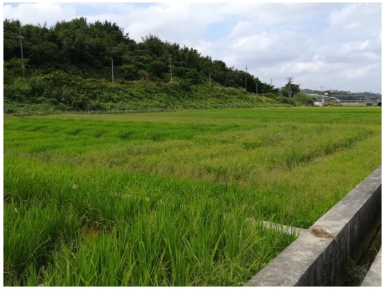
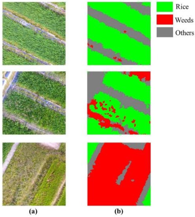
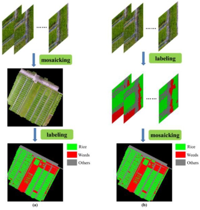
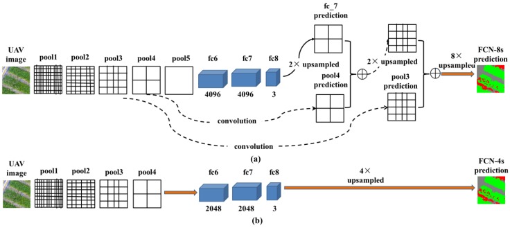
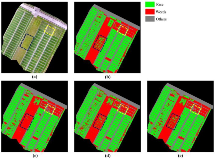
Chemical control is necessary in order to control weed infestation and to ensure a rice yield. However, excessive use of herbicides has caused serious agronomic and environmental problems. Site specific weed management (SSWM) recommends an appropriate dose of herbicides according to the weed coverage, which may reduce the use of herbicides while enhancing their chemical effects. In the context of SSWM, the weed cover map and prescription map must be generated in order to carry out the accurate spraying. In this paper, high resolution unmanned aerial vehicle (UAV) imagery were captured over a rice field. Different workflows were evaluated to generate the weed cover map for the whole field. Fully convolutional networks (FCN) was applied for a pixel-level classification. Theoretical analysis and practical evaluation were carried out to seek for an architecture improvement and performance boost. A chessboard segmentation process was used to build the grid framework of the prescription map. The experimental results showed that the overall accuracy and mean intersection over union (mean IU) for weed mapping using FCN-4s were 0.9196 and 0.8473, and the total time (including the data collection and data processing) required to generate the weed cover map for the entire field (50 × 60 m) was less than half an hour. Different weed thresholds (0.00⁻0.25, with an interval of 0.05) were used for the prescription map generation. High accuracies (above 0.94) were observed for all of the threshold values, and the relevant herbicide saving ranged from 58.3% to 70.8%. All of the experimental results demonstrated that the method used in this work has the potential to produce an accurate weed cover map and prescription map in SSWM applications.

摘要

为了控制杂草滋生,确保水稻产量,需要进行化学防治。然而,过度使用除草剂会导致严重的农业和环境问题。特定地点杂草管理(SSWM)建议根据杂草覆盖率使用适当剂量的除草剂,这可能会减少除草剂的使用量,同时增强其化学效果。在 SSWM 的背景下,必须生成杂草覆盖图和处方图,以便进行精确喷洒。本文在稻田上空拍摄了高分辨率的无人机(UAV)图像。评估了不同的工作流程,以生成整个田地的杂草覆盖图。全卷积网络(FCN)用于像素级分类。进行了理论分析和实际评估,以寻求架构改进和性能提升。使用棋盘分割过程构建处方图的网格框架。实验结果表明,使用 FCN-4s 进行杂草制图的总体准确率和平均交并比(mean IU)分别为 0.9196 和 0.8473,生成整个田地(50×60 m)的杂草覆盖图所需的总时间(包括数据采集和数据处理)不到半小时。为处方图生成使用了不同的杂草阈值(0.00⁻0.25,间隔为 0.05)。所有阈值的准确率都在 0.94 以上,相关的除草剂节省率在 58.3%至 70.8%之间。所有实验结果表明,本工作中使用的方法具有在 SSWM 应用中生成准确的杂草覆盖图和处方图的潜力。

https://cdn.ncbi.nlm.nih.gov/pmc/blobs/e6e7/6209949/771f542a3888/sensors-18-03299-g007.jpg
https://cdn.ncbi.nlm.nih.gov/pmc/blobs/e6e7/6209949/57785d799f5f/sensors-18-03299-g001.jpg
https://cdn.ncbi.nlm.nih.gov/pmc/blobs/e6e7/6209949/f8237690aeda/sensors-18-03299-g002.jpg
https://cdn.ncbi.nlm.nih.gov/pmc/blobs/e6e7/6209949/a5ba2be07d42/sensors-18-03299-g003.jpg
https://cdn.ncbi.nlm.nih.gov/pmc/blobs/e6e7/6209949/184ed8940737/sensors-18-03299-g004.jpg
https://cdn.ncbi.nlm.nih.gov/pmc/blobs/e6e7/6209949/13626460d88f/sensors-18-03299-g005.jpg
https://cdn.ncbi.nlm.nih.gov/pmc/blobs/e6e7/6209949/242824ca1998/sensors-18-03299-g006.jpg
https://cdn.ncbi.nlm.nih.gov/pmc/blobs/e6e7/6209949/771f542a3888/sensors-18-03299-g007.jpg

相似文献

1
Accurate Weed Mapping and Prescription Map Generation Based on Fully Convolutional Networks Using UAV Imagery.基于无人机图像的全卷积网络的精确杂草测绘和处方图生成。
Sensors (Basel). 2018 Oct 1;18(10):3299. doi: 10.3390/s18103299.
2
A Semantic Labeling Approach for Accurate Weed Mapping of High Resolution UAV Imagery.基于语义标注的高分辨率无人机影像杂草精准分类方法
Sensors (Basel). 2018 Jul 1;18(7):2113. doi: 10.3390/s18072113.
3
A fully convolutional network for weed mapping of unmanned aerial vehicle (UAV) imagery.基于无人机影像的杂草图全自动卷积神经网络
PLoS One. 2018 Apr 26;13(4):e0196302. doi: 10.1371/journal.pone.0196302. eCollection 2018.
4
Deep Convolutional Neural Network for Flood Extent Mapping Using Unmanned Aerial Vehicles Data.基于无人机数据的深度卷积神经网络洪水淹没范围制图
Sensors (Basel). 2019 Mar 27;19(7):1486. doi: 10.3390/s19071486.
5
Agronomic and Technical Evaluation of Herbicide Spot Spraying in Maize Based on High-Resolution Aerial Weed Maps-An On-Farm Trial.基于高分辨率航空杂草地图的玉米田除草剂点喷农艺与技术评估——一项田间试验
Plants (Basel). 2024 Aug 5;13(15):2164. doi: 10.3390/plants13152164.
6
Integration of remote-weed mapping and an autonomous spraying unmanned aerial vehicle for site-specific weed management.远程杂草测绘与自主喷洒无人机的整合,实现了特定地点杂草管理。
Pest Manag Sci. 2020 Apr;76(4):1386-1392. doi: 10.1002/ps.5651. Epub 2019 Nov 12.
7
Towards reducing chemical usage for weed control in agriculture using UAS imagery analysis and computer vision techniques.利用无人机影像分析和计算机视觉技术减少农业杂草控制中的化学农药使用。
Sci Rep. 2023 Apr 21;13(1):6548. doi: 10.1038/s41598-023-33042-0.
8
Weed mapping in early-season maize fields using object-based analysis of unmanned aerial vehicle (UAV) images.利用基于对象的无人机 (UAV) 图像分析进行早春玉米田杂草制图。
PLoS One. 2013 Oct 11;8(10):e77151. doi: 10.1371/journal.pone.0077151. eCollection 2013.
9
Spatial Quality Evaluation of Resampled Unmanned Aerial Vehicle-Imagery for Weed Mapping.用于杂草制图的重采样无人机影像的空间质量评估
Sensors (Basel). 2015 Aug 12;15(8):19688-708. doi: 10.3390/s150819688.
10
Quantifying efficacy and limits of unmanned aerial vehicle (UAV) technology for weed seedling detection as affected by sensor resolution.量化受传感器分辨率影响的无人机(UAV)技术在杂草幼苗检测方面的功效及局限性。
Sensors (Basel). 2015 Mar 6;15(3):5609-26. doi: 10.3390/s150305609.

引用本文的文献

1
Remote sensing assessment of the weed adaptability to soil salinization induced by extreme droughts on coastal agriculture.遥感评估极端干旱对沿海农业土壤盐渍化诱导的杂草适应性
iScience. 2025 Apr 11;28(5):112410. doi: 10.1016/j.isci.2025.112410. eCollection 2025 May 16.
2
Deep learning and hyperspectral features for seedling stage identification of barnyard grass in paddy field.基于深度学习和高光谱特征的稻田稗草幼苗期识别
Front Plant Sci. 2025 Feb 7;16:1507442. doi: 10.3389/fpls.2025.1507442. eCollection 2025.
3
Review of Current Robotic Approaches for Precision Weed Management.

本文引用的文献

1
A Semantic Labeling Approach for Accurate Weed Mapping of High Resolution UAV Imagery.基于语义标注的高分辨率无人机影像杂草精准分类方法
Sensors (Basel). 2018 Jul 1;18(7):2113. doi: 10.3390/s18072113.
2
A fully convolutional network for weed mapping of unmanned aerial vehicle (UAV) imagery.基于无人机影像的杂草图全自动卷积神经网络
PLoS One. 2018 Apr 26;13(4):e0196302. doi: 10.1371/journal.pone.0196302. eCollection 2018.
3
Mechanism of resistance to cyhalofop-butyl in Chinese sprangletop (Leptochloa chinensis (L.) Nees).对氟吡草腙在节节麦(Leptochloa chinensis (L.) Nees)中产生抗性的机制。
当前用于精准杂草管理的机器人方法综述。
Curr Robot Rep. 2022;3(3):139-151. doi: 10.1007/s43154-022-00086-5. Epub 2022 Jul 22.
4
Review of Weed Detection Methods Based on Computer Vision.基于计算机视觉的杂草检测方法综述。
Sensors (Basel). 2021 May 24;21(11):3647. doi: 10.3390/s21113647.
5
Machine Learning in Agriculture: A Comprehensive Updated Review.农业中的机器学习:全面更新的综述。
Sensors (Basel). 2021 May 28;21(11):3758. doi: 10.3390/s21113758.
6
A novel semi-supervised framework for UAV based crop/weed classification.基于无人机的作物/杂草分类的新型半监督框架。
PLoS One. 2021 May 10;16(5):e0251008. doi: 10.1371/journal.pone.0251008. eCollection 2021.
7
Fully convolutional network for rice seedling and weed image segmentation at the seedling stage in paddy fields.基于全卷积网络的稻田秧苗期水稻苗和杂草图像分割。
PLoS One. 2019 Apr 18;14(4):e0215676. doi: 10.1371/journal.pone.0215676. eCollection 2019.
8
Computer vision-based phenotyping for improvement of plant productivity: a machine learning perspective.基于计算机视觉的表型分析提高植物生产力:机器学习视角。
Gigascience. 2019 Jan 1;8(1):giy153. doi: 10.1093/gigascience/giy153.
Pestic Biochem Physiol. 2017 Nov;143:306-311. doi: 10.1016/j.pestbp.2016.11.001. Epub 2016 Nov 12.
4
DeepLab: Semantic Image Segmentation with Deep Convolutional Nets, Atrous Convolution, and Fully Connected CRFs.DeepLab:基于深度卷积网络、空洞卷积和全连接条件随机场的语义图像分割。
IEEE Trans Pattern Anal Mach Intell. 2018 Apr;40(4):834-848. doi: 10.1109/TPAMI.2017.2699184. Epub 2017 Apr 27.
5
Fully Convolutional Networks for Semantic Segmentation.全卷积网络用于语义分割。
IEEE Trans Pattern Anal Mach Intell. 2017 Apr;39(4):640-651. doi: 10.1109/TPAMI.2016.2572683. Epub 2016 May 24.
6
Deep learning.深度学习。
Nature. 2015 May 28;521(7553):436-44. doi: 10.1038/nature14539.
7
Weed mapping in early-season maize fields using object-based analysis of unmanned aerial vehicle (UAV) images.利用基于对象的无人机 (UAV) 图像分析进行早春玉米田杂草制图。
PLoS One. 2013 Oct 11;8(10):e77151. doi: 10.1371/journal.pone.0077151. eCollection 2013.
8
The lethal effects of Cyperus iria on Aedes aegypti.香附子对埃及伊蚊的致死作用。
J Am Mosq Control Assoc. 1998 Mar;14(1):78-82.