• 文献检索
  • 文档翻译
  • 深度研究
  • 学术资讯
  • Suppr Zotero 插件Zotero 插件
  • 邀请有礼
  • 套餐&价格
  • 历史记录
应用&插件
Suppr Zotero 插件Zotero 插件浏览器插件Mac 客户端Windows 客户端微信小程序
定价
高级版会员购买积分包购买API积分包
服务
文献检索文档翻译深度研究API 文档MCP 服务
关于我们
关于 Suppr公司介绍联系我们用户协议隐私条款
关注我们

Suppr 超能文献

核心技术专利:CN118964589B侵权必究
粤ICP备2023148730 号-1Suppr @ 2026

文献检索

告别复杂PubMed语法,用中文像聊天一样搜索,搜遍4000万医学文献。AI智能推荐,让科研检索更轻松。

立即免费搜索

文件翻译

保留排版,准确专业,支持PDF/Word/PPT等文件格式,支持 12+语言互译。

免费翻译文档

深度研究

AI帮你快速写综述,25分钟生成高质量综述,智能提取关键信息,辅助科研写作。

立即免费体验

通过超高密度无人机激光雷达实现森林遥感的新机遇。

New Opportunities for Forest Remote Sensing Through Ultra-High-Density Drone Lidar.

作者信息

Kellner James R, Armston John, Birrer Markus, Cushman K C, Duncanson Laura, Eck Christoph, Falleger Christoph, Imbach Benedikt, Král Kamil, Krůček Martin, Trochta Jan, Vrška Tomáš, Zgraggen Carlo

机构信息

1Institute at Brown for Environment and Society, Brown University, 85 Waterman Street, Providence, RI 02912 USA.

2Department of Ecology and Evolutionary Biology, Brown University, 80 Waterman Street, Providence, RI 02912 USA.

出版信息

Surv Geophys. 2019;40(4):959-977. doi: 10.1007/s10712-019-09529-9. Epub 2019 May 4.

DOI:10.1007/s10712-019-09529-9
PMID:31395993
原文链接:https://pmc.ncbi.nlm.nih.gov/articles/PMC6647463/
Abstract

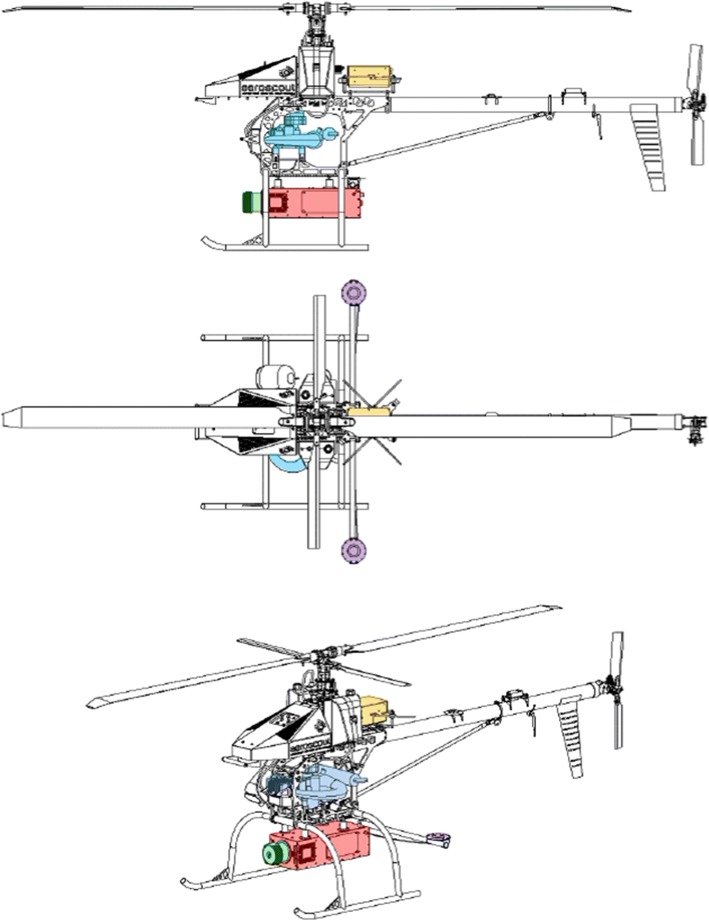
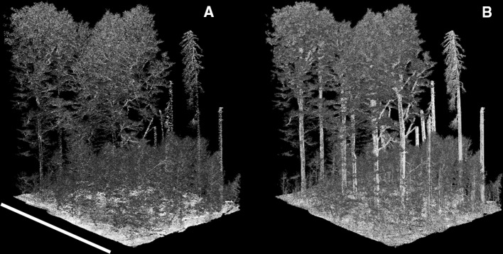
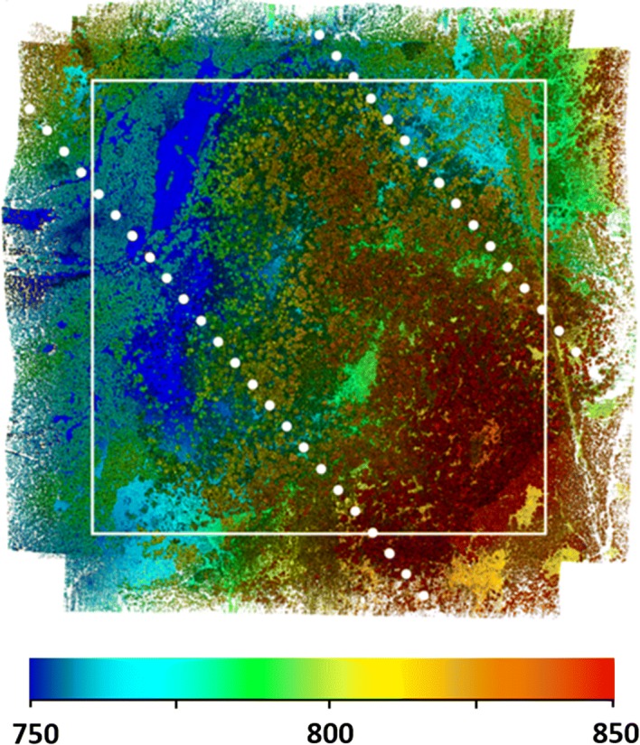
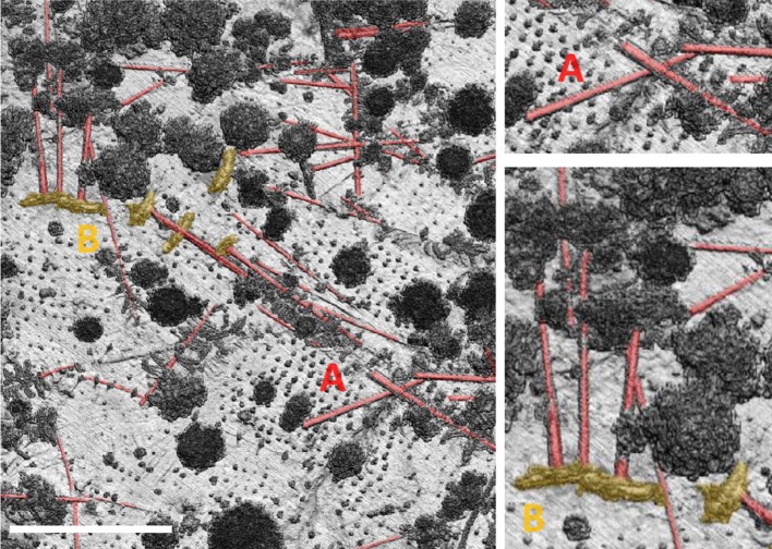
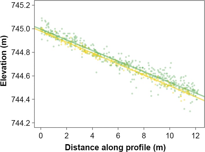
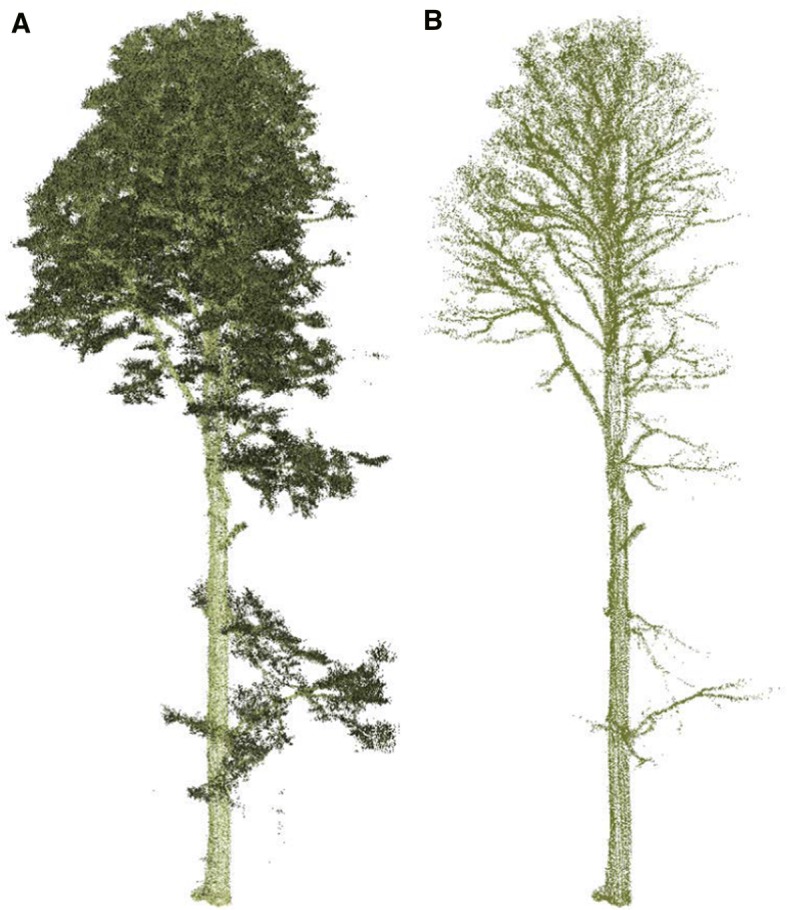
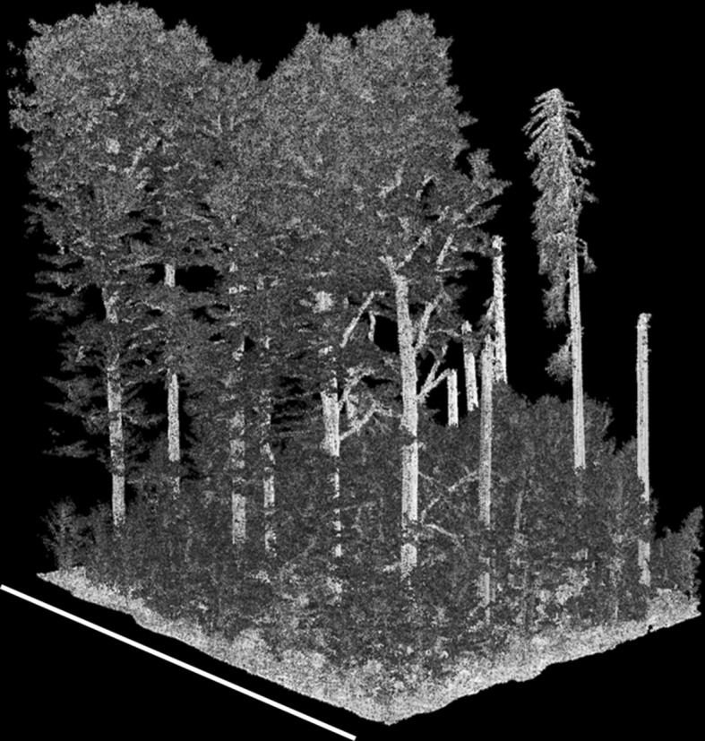
Current and planned space missions will produce aboveground biomass density data products at varying spatial resolution. Calibration and validation of these data products is critically dependent on the existence of field estimates of aboveground biomass and coincident remote sensing data from airborne or terrestrial lidar. There are few places that meet these requirements, and they are mostly in the northern hemisphere and temperate zone. Here we summarize the potential for low-altitude drones to produce new observations in support of mission science. We describe technical requirements for producing high-quality measurements from autonomous platforms and highlight differences among commercially available laser scanners and drone aircraft. We then describe a case study using a heavy-lift autonomous helicopter in a temperate mountain forest in the southern Czech Republic in support of calibration and validation activities for the NASA Global Ecosystem Dynamics Investigation. Low-altitude flight using drones enables the collection of ultra-high-density point clouds using wider laser scan angles than have been possible from traditional airborne platforms. These measurements can be precise and accurate and can achieve measurement densities of thousands of points · m. Analysis of surface elevation measurements on a heterogeneous target observed 51 days apart indicates that the realized range accuracy is 2.4 cm. The single-date precision is 2.1-4.5 cm. These estimates are net of all processing artifacts and geolocation errors under fully autonomous flight. The 3D model produced by these data can clearly resolve branch and stem structure that is comparable to terrestrial laser scans and can be acquired rapidly over large landscapes at a fraction of the cost of traditional airborne laser scanning.

摘要

当前及计划中的太空任务将生成不同空间分辨率的地上生物量密度数据产品。这些数据产品的校准和验证严重依赖于地上生物量的实地估计以及来自机载或地面激光雷达的同步遥感数据。满足这些要求的地方很少,而且大多位于北半球和温带地区。在此,我们总结了低空无人机为支持任务科学而进行新观测的潜力。我们描述了从自主平台获取高质量测量数据的技术要求,并强调了市售激光扫描仪和无人机之间的差异。然后,我们描述了一个案例研究,该研究在捷克共和国南部的温带山林中使用重型自主直升机,以支持美国国家航空航天局全球生态系统动力学调查的校准和验证活动。使用无人机进行低空飞行能够利用比传统机载平台更宽的激光扫描角度收集超高密度点云。这些测量可以精确且准确,并且可以实现数千点·米的测量密度。对间隔51天观测的异质目标上的表面高程测量分析表明,实际测距精度为2.4厘米。单日精度为2.1 - 4.5厘米。这些估计值是在完全自主飞行下扣除所有处理伪像和地理定位误差后的结果。由这些数据生成的三维模型能够清晰分辨树枝和树干结构,可与地面激光扫描相媲美,并且能够以传统机载激光扫描成本的一小部分在大片区域快速获取。

https://cdn.ncbi.nlm.nih.gov/pmc/blobs/e78f/6647463/c8f1684810cc/10712_2019_9529_Fig7_HTML.jpg
https://cdn.ncbi.nlm.nih.gov/pmc/blobs/e78f/6647463/73fcd0354640/10712_2019_9529_Fig1_HTML.jpg
https://cdn.ncbi.nlm.nih.gov/pmc/blobs/e78f/6647463/6a8d525eea8d/10712_2019_9529_Fig2_HTML.jpg
https://cdn.ncbi.nlm.nih.gov/pmc/blobs/e78f/6647463/1f0ffbb9e006/10712_2019_9529_Fig3_HTML.jpg
https://cdn.ncbi.nlm.nih.gov/pmc/blobs/e78f/6647463/4a210a41718f/10712_2019_9529_Fig4_HTML.jpg
https://cdn.ncbi.nlm.nih.gov/pmc/blobs/e78f/6647463/c48510e1adc4/10712_2019_9529_Fig5_HTML.jpg
https://cdn.ncbi.nlm.nih.gov/pmc/blobs/e78f/6647463/ac81f7c20067/10712_2019_9529_Fig6_HTML.jpg
https://cdn.ncbi.nlm.nih.gov/pmc/blobs/e78f/6647463/c8f1684810cc/10712_2019_9529_Fig7_HTML.jpg

相似文献

1
New Opportunities for Forest Remote Sensing Through Ultra-High-Density Drone Lidar.通过超高密度无人机激光雷达实现森林遥感的新机遇。
Surv Geophys. 2019;40(4):959-977. doi: 10.1007/s10712-019-09529-9. Epub 2019 May 4.
2
Airborne lidar-based estimates of tropical forest structure in complex terrain: opportunities and trade-offs for REDD+.基于机载激光雷达的复杂地形中热带森林结构估计:减少毁林和森林退化所致排放量(REDD+)的机遇与权衡
Carbon Balance Manag. 2015 Feb 3;10(1):3. doi: 10.1186/s13021-015-0013-x. eCollection 2015 Dec.
3
Spatial heterogeneity of global forest aboveground carbon stocks and fluxes constrained by spaceborne lidar data and mechanistic modeling.基于星载激光雷达数据和机理模型约束的全球森林地上碳储量和通量的空间异质性。
Glob Chang Biol. 2023 Jun;29(12):3378-3394. doi: 10.1111/gcb.16682. Epub 2023 Apr 4.
4
The GEDI Simulator: A Large-Footprint Waveform Lidar Simulator for Calibration and Validation of Spaceborne Missions.GEDI模拟器:一种用于校准和验证星载任务的大尺寸波形激光雷达模拟器。
Earth Space Sci. 2019 Feb;6(2):294-310. doi: 10.1029/2018EA000506. Epub 2019 Feb 27.
5
Using Lidar and Radar measurements to constrain predictions of forest ecosystem structure and function.利用激光雷达和雷达测量来约束森林生态系统结构和功能的预测。
Ecol Appl. 2011 Jun;21(4):1120-37. doi: 10.1890/10-0274.1.
6
Scaling wood volume estimates from inventory plots to landscapes with airborne LiDAR in temperate deciduous forest.利用机载激光雷达将温带落叶林清查样地的木材体积估计值扩展到景观尺度。
Carbon Balance Manag. 2016 May 31;11(1):7. doi: 10.1186/s13021-016-0048-7. eCollection 2016 Dec.
7
Systematic Approach for Remote Sensing of Historical Conflict Landscapes with UAV-Based Laserscanning.基于无人机激光扫描的历史冲突景观遥感系统方法。
Sensors (Basel). 2021 Dec 29;22(1):217. doi: 10.3390/s22010217.
8
The Importance of Consistent Global Forest Aboveground Biomass Product Validation.全球森林地上生物量产品一致性验证的重要性。
Surv Geophys. 2019;40(4):979-999. doi: 10.1007/s10712-019-09538-8. Epub 2019 May 30.
9
Amazonian landscapes and the bias in field studies of forest structure and biomass.亚马逊地区的地貌以及森林结构与生物量实地研究中的偏差。
Proc Natl Acad Sci U S A. 2014 Dec 2;111(48):E5224-32. doi: 10.1073/pnas.1412999111. Epub 2014 Nov 24.
10
Multitemporal lidar captures heterogeneity in fuel loads and consumption on the Kaibab Plateau.多时相激光雷达捕捉到了凯巴布高原燃料负荷和消耗的异质性。
Fire Ecol. 2022;18(1):18. doi: 10.1186/s42408-022-00142-7. Epub 2022 Aug 9.

引用本文的文献

1
Drones in ecology: ten years back and forth.生态领域中的无人机:十年的起伏历程
Bioscience. 2025 Jun 19;75(8):664-680. doi: 10.1093/biosci/biaf069. eCollection 2025 Aug.
2
Drone-assisted time-varying magnetic field analysis for fault diagnosis in grounding grids.用于接地网故障诊断的无人机辅助时变磁场分析
PLoS One. 2025 Jun 17;20(6):e0325845. doi: 10.1371/journal.pone.0325845. eCollection 2025.
3
Three-Dimensional Point Cloud Applications, Datasets, and Compression Methodologies for Remote Sensing: A Meta-Survey.用于遥感的三维点云应用、数据集和压缩方法:一项元调查

本文引用的文献

1
The Importance of Consistent Global Forest Aboveground Biomass Product Validation.全球森林地上生物量产品一致性验证的重要性。
Surv Geophys. 2019;40(4):979-999. doi: 10.1007/s10712-019-09538-8. Epub 2019 May 30.
2
The GEDI Simulator: A Large-Footprint Waveform Lidar Simulator for Calibration and Validation of Spaceborne Missions.GEDI模拟器:一种用于校准和验证星载任务的大尺寸波形激光雷达模拟器。
Earth Space Sci. 2019 Feb;6(2):294-310. doi: 10.1029/2018EA000506. Epub 2019 Feb 27.
3
Weighing trees with lasers: advances, challenges and opportunities.
Sensors (Basel). 2025 Mar 7;25(6):1660. doi: 10.3390/s25061660.
4
Individual tree segmentation of airborne and UAV LiDAR point clouds based on the watershed and optimized connection center evolution clustering.基于分水岭算法和优化连接中心演化聚类的机载和无人机激光雷达点云单木分割
Ecol Evol. 2023 Jul 12;13(7):e10297. doi: 10.1002/ece3.10297. eCollection 2023 Jul.
5
The Importance of Consistent Global Forest Aboveground Biomass Product Validation.全球森林地上生物量产品一致性验证的重要性。
Surv Geophys. 2019;40(4):979-999. doi: 10.1007/s10712-019-09538-8. Epub 2019 May 30.
利用激光测量树木:进展、挑战与机遇
Interface Focus. 2018 Apr 6;8(2):20170048. doi: 10.1098/rsfs.2017.0048. Epub 2018 Feb 16.
4
Comparing RIEGL RiCOPTER UAV LiDAR Derived Canopy Height and DBH with Terrestrial LiDAR.比较RIEGL RiCOPTER无人机激光雷达获取的树冠高度和胸径与地面激光雷达的结果。
Sensors (Basel). 2017 Oct 17;17(10):2371. doi: 10.3390/s17102371.
5
ISS observations offer insights into plant function.国际空间站的观测为了解植物功能提供了见解。
Nat Ecol Evol. 2017 Jun 22;1(7):194. doi: 10.1038/s41559-017-0194.
6
3D Forest: An application for descriptions of three-dimensional forest structures using terrestrial LiDAR.3D森林:一种使用地面激光雷达描述三维森林结构的应用程序。
PLoS One. 2017 May 4;12(5):e0176871. doi: 10.1371/journal.pone.0176871. eCollection 2017.
7
Adult mortality in a low-density tree population using high-resolution remote sensing.利用高分辨率遥感技术研究低密度树种群的成年个体死亡率。
Ecology. 2017 Jun;98(6):1700-1709. doi: 10.1002/ecy.1847. Epub 2017 May 11.
8
Light-driven growth in Amazon evergreen forests explained by seasonal variations of vertical canopy structure.亚马逊常绿森林中由垂直冠层结构的季节性变化所解释的光驱动生长。
Proc Natl Acad Sci U S A. 2017 Mar 7;114(10):2640-2644. doi: 10.1073/pnas.1616943114. Epub 2017 Feb 21.
9
CTFS-ForestGEO: a worldwide network monitoring forests in an era of global change.CTFS-ForestGEO:一个在全球变化时代监测森林的全球网络。
Glob Chang Biol. 2015 Feb;21(2):528-49. doi: 10.1111/gcb.12712. Epub 2014 Sep 25.
10
Improved allometric models to estimate the aboveground biomass of tropical trees.改进的异速生长模型来估算热带树木的地上生物量。
Glob Chang Biol. 2014 Oct;20(10):3177-90. doi: 10.1111/gcb.12629. Epub 2014 Jun 21.