• 文献检索
  • 文档翻译
  • 深度研究
  • 学术资讯
  • Suppr Zotero 插件Zotero 插件
  • 邀请有礼
  • 套餐&价格
  • 历史记录
应用&插件
Suppr Zotero 插件Zotero 插件浏览器插件Mac 客户端Windows 客户端微信小程序
定价
高级版会员购买积分包购买API积分包
服务
文献检索文档翻译深度研究API 文档MCP 服务
关于我们
关于 Suppr公司介绍联系我们用户协议隐私条款
关注我们

Suppr 超能文献

核心技术专利:CN118964589B侵权必究
粤ICP备2023148730 号-1Suppr @ 2026

文献检索

告别复杂PubMed语法,用中文像聊天一样搜索,搜遍4000万医学文献。AI智能推荐,让科研检索更轻松。

立即免费搜索

文件翻译

保留排版,准确专业,支持PDF/Word/PPT等文件格式,支持 12+语言互译。

免费翻译文档

深度研究

AI帮你快速写综述,25分钟生成高质量综述,智能提取关键信息,辅助科研写作。

立即免费体验

利用全球导航卫星系统/惯性测量单元/激光雷达传感器集成创建高清3D地图以支持自动驾驶车辆导航。

High Definition 3D Map Creation Using GNSS/IMU/LiDAR Sensor Integration to Support Autonomous Vehicle Navigation.

作者信息

Ilci Veli, Toth Charles

机构信息

Department of Geomatics Engineering, Ondokuz Mayis University, 55139 Atakum, Turkey.

Department of Civil, Environmental and Geodetic Engineering, Ohio State University, Columbus, OH 43210, USA.

出版信息

Sensors (Basel). 2020 Feb 7;20(3):899. doi: 10.3390/s20030899.

DOI:10.3390/s20030899
PMID:32046232
原文链接:https://pmc.ncbi.nlm.nih.gov/articles/PMC7039384/
Abstract

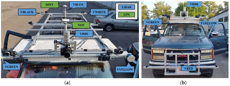
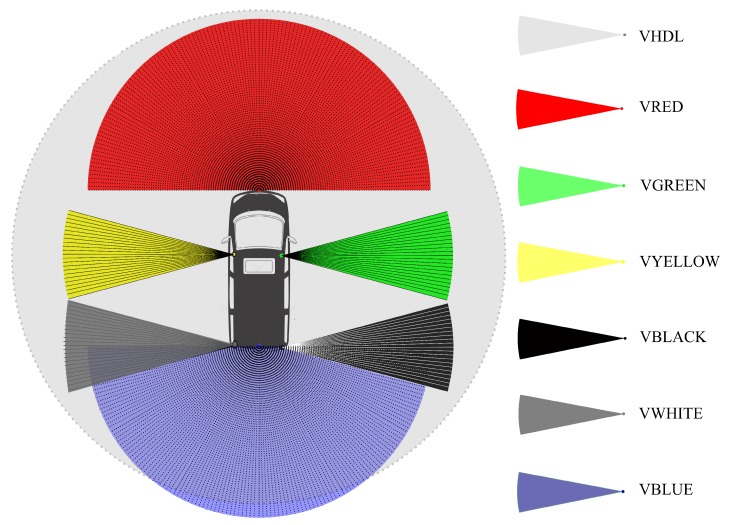
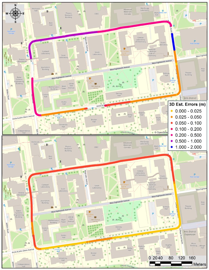
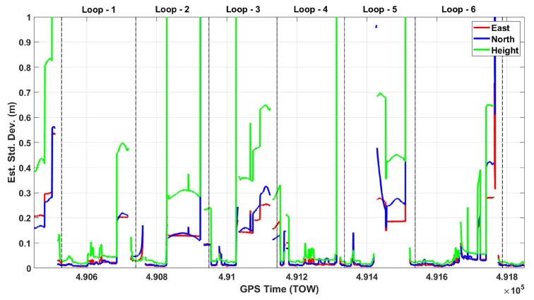
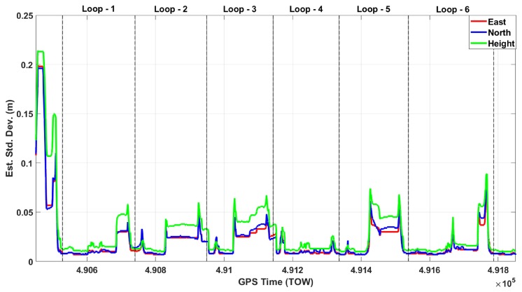
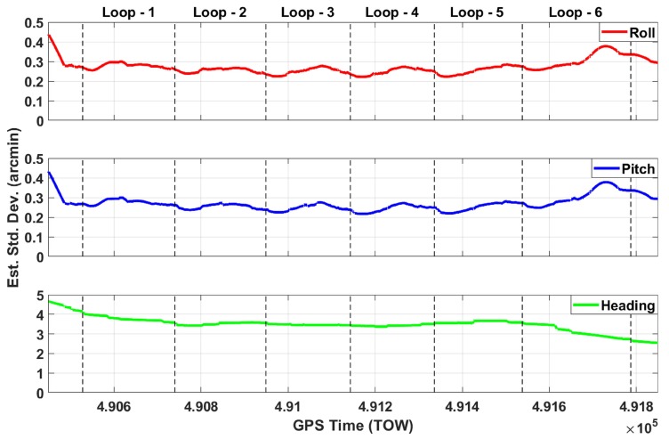
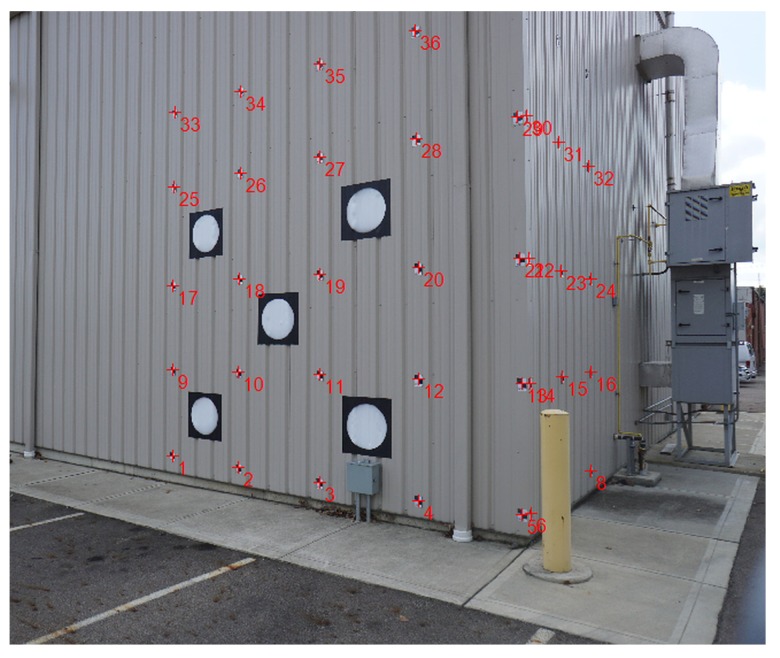
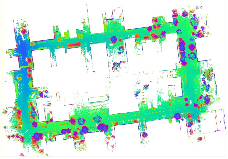
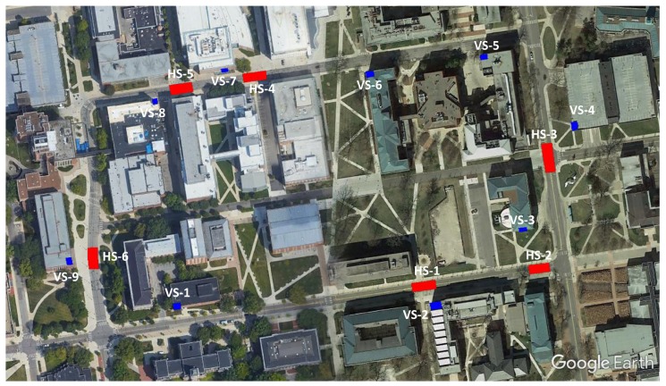
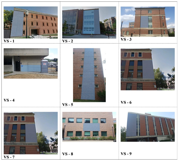
Recent developments in sensor technologies such as Global Navigation Satellite Systems (GNSS), Inertial Measurement Unit (IMU), Light Detection and Ranging (LiDAR), radar, and camera have led to emerging state-of-the-art autonomous systems, such as driverless vehicles or UAS (Unmanned Airborne Systems) swarms. These technologies necessitate the use of accurate object space information about the physical environment around the platform. This information can be generally provided by the suitable selection of the sensors, including sensor types and capabilities, the number of sensors, and their spatial arrangement. Since all these sensor technologies have different error sources and characteristics, rigorous sensor modeling is needed to eliminate/mitigate errors to obtain an accurate, reliable, and robust integrated solution. Mobile mapping systems are very similar to autonomous vehicles in terms of being able to reconstruct the environment around the platforms. However, they differ a lot in operations and objectives. Mobile mapping vehicles use professional grade sensors, such as geodetic grade GNSS, tactical grade IMU, mobile LiDAR, and metric cameras, and the solution is created in post-processing. In contrast, autonomous vehicles use simple/inexpensive sensors, require real-time operations, and are primarily interested in identifying and tracking moving objects. In this study, the main objective was to assess the performance potential of autonomous vehicle sensor systems to obtain high-definition maps based on only using Velodyne sensor data for creating accurate point clouds. In other words, no other sensor data were considered in this investigation. The results have confirmed that cm-level accuracy can be achieved.

摘要

全球导航卫星系统(GNSS)、惯性测量单元(IMU)、光探测与测距(LiDAR)、雷达和摄像头等传感器技术的最新发展催生了诸如无人驾驶车辆或无人机群等新兴的先进自主系统。这些技术需要使用有关平台周围物理环境的精确目标空间信息。通常可以通过适当选择传感器来提供此信息,包括传感器类型和功能、传感器数量及其空间布局。由于所有这些传感器技术都有不同的误差源和特性,因此需要进行严格的传感器建模以消除/减轻误差,从而获得准确、可靠且稳健的集成解决方案。移动测绘系统在能够重建平台周围环境方面与自动驾驶车辆非常相似。然而,它们在操作和目标方面有很大差异。移动测绘车辆使用专业级传感器,如大地测量级GNSS、战术级IMU、移动LiDAR和测量相机,并且解决方案是在后期处理中创建的。相比之下,自动驾驶车辆使用简单/廉价的传感器,需要实时操作,并且主要关注识别和跟踪移动物体。在本研究中,主要目标是评估自动驾驶车辆传感器系统仅使用Velodyne传感器数据创建精确点云以获取高清地图的性能潜力。换句话说,本研究未考虑其他传感器数据。结果证实可以实现厘米级精度。

https://cdn.ncbi.nlm.nih.gov/pmc/blobs/2341/7039384/58d07d8d4588/sensors-20-00899-g012.jpg
https://cdn.ncbi.nlm.nih.gov/pmc/blobs/2341/7039384/4b81b08cfef8/sensors-20-00899-g001.jpg
https://cdn.ncbi.nlm.nih.gov/pmc/blobs/2341/7039384/632334c18b92/sensors-20-00899-g002.jpg
https://cdn.ncbi.nlm.nih.gov/pmc/blobs/2341/7039384/79310e614241/sensors-20-00899-g003.jpg
https://cdn.ncbi.nlm.nih.gov/pmc/blobs/2341/7039384/d201d727daca/sensors-20-00899-g004.jpg
https://cdn.ncbi.nlm.nih.gov/pmc/blobs/2341/7039384/d2cd7299e236/sensors-20-00899-g005.jpg
https://cdn.ncbi.nlm.nih.gov/pmc/blobs/2341/7039384/82cb39680223/sensors-20-00899-g006.jpg
https://cdn.ncbi.nlm.nih.gov/pmc/blobs/2341/7039384/0fd092547e70/sensors-20-00899-g007.jpg
https://cdn.ncbi.nlm.nih.gov/pmc/blobs/2341/7039384/bd7e4ec035e5/sensors-20-00899-g008.jpg
https://cdn.ncbi.nlm.nih.gov/pmc/blobs/2341/7039384/39af365ff35f/sensors-20-00899-g009.jpg
https://cdn.ncbi.nlm.nih.gov/pmc/blobs/2341/7039384/32c05464f823/sensors-20-00899-g010.jpg
https://cdn.ncbi.nlm.nih.gov/pmc/blobs/2341/7039384/2a3b94b8d194/sensors-20-00899-g011.jpg
https://cdn.ncbi.nlm.nih.gov/pmc/blobs/2341/7039384/58d07d8d4588/sensors-20-00899-g012.jpg

相似文献

1
High Definition 3D Map Creation Using GNSS/IMU/LiDAR Sensor Integration to Support Autonomous Vehicle Navigation.利用全球导航卫星系统/惯性测量单元/激光雷达传感器集成创建高清3D地图以支持自动驾驶车辆导航。
Sensors (Basel). 2020 Feb 7;20(3):899. doi: 10.3390/s20030899.
2
Pole-Like Object Extraction and Pole-Aided GNSS/IMU/LiDAR-SLAM System in Urban Area.城区中杆状物体提取及基于杆辅助的GNSS/IMU/LiDAR-SLAM系统
Sensors (Basel). 2020 Dec 13;20(24):7145. doi: 10.3390/s20247145.
3
GNSS/IMU/ODO/LiDAR-SLAM Integrated Navigation System Using IMU/ODO Pre-Integration.采用惯性测量单元/里程计预积分的全球导航卫星系统/惯性测量单元/里程计/激光雷达同步定位与地图构建集成导航系统
Sensors (Basel). 2020 Aug 20;20(17):4702. doi: 10.3390/s20174702.
4
Cost Effective Mobile Mapping System for Color Point Cloud Reconstruction.用于彩色点云重建的经济高效移动测绘系统
Sensors (Basel). 2020 Nov 16;20(22):6536. doi: 10.3390/s20226536.
5
A Robust Vehicle Localization Approach Based on GNSS/IMU/DMI/LiDAR Sensor Fusion for Autonomous Vehicles.一种基于GNSS/IMU/DMI/激光雷达传感器融合的用于自动驾驶车辆的稳健车辆定位方法。
Sensors (Basel). 2017 Sep 18;17(9):2140. doi: 10.3390/s17092140.
6
A Novel Approach to Global Positioning System Accuracy Assessment, Verified on LiDAR Alignment of One Million Kilometers at a Continent Scale, as a Foundation for Autonomous DRIVING Safety Analysis.一种全球定位系统精度评估的新方法,在大陆尺度上通过一百万公里的激光雷达校准进行验证,作为自动驾驶安全分析的基础。
Sensors (Basel). 2021 Aug 24;21(17):5691. doi: 10.3390/s21175691.
7
Investigating Practical Impacts of Using Single-Antenna and Dual-Antenna GNSS/INS Sensors in UAS-Lidar Applications.研究单天线和双天线 GNSS/INS 传感器在无人机激光雷达应用中的实际影响。
Sensors (Basel). 2021 Aug 9;21(16):5382. doi: 10.3390/s21165382.
8
Road Profile Estimation Using a 3D Sensor and Intelligent Vehicle.使用3D传感器和智能车辆进行道路轮廓估计
Sensors (Basel). 2020 Jun 30;20(13):3676. doi: 10.3390/s20133676.
9
A GNSS/INS/LiDAR Integration Scheme for UAV-Based Navigation in GNSS-Challenging Environments.一种用于 GNSS 挑战性环境中基于无人机的导航的 GNSS/INS/LiDAR 集成方案。
Sensors (Basel). 2022 Dec 16;22(24):9908. doi: 10.3390/s22249908.
10
GNSS/LiDAR-Based Navigation of an Aerial Robot in Sparse Forests.基于 GNSS/LiDAR 的稀疏林区空中机器人导航。
Sensors (Basel). 2019 Sep 20;19(19):4061. doi: 10.3390/s19194061.

引用本文的文献

1
Building the Future of Transportation: A Comprehensive Survey on AV Perception, Localization, and Mapping.构建交通的未来:关于自动驾驶汽车感知、定位和地图绘制的全面综述。
Sensors (Basel). 2025 Mar 23;25(7):2004. doi: 10.3390/s25072004.
2
Generating Seamless Three-Dimensional Maps by Integrating Low-Cost Unmanned Aerial Vehicle Imagery and Mobile Mapping System Data.通过整合低成本无人机图像和移动测绘系统数据生成无缝三维地图。
Sensors (Basel). 2025 Jan 30;25(3):822. doi: 10.3390/s25030822.
3
A Registration Method Based on Ordered Point Clouds for Key Components of Trains.

本文引用的文献

1
Kinematic and Dynamic Vehicle Model-Assisted Global Positioning Method for Autonomous Vehicles with Low-Cost GPS/Camera/In-Vehicle Sensors.低成本 GPS/相机/车载传感器的自主车辆运动学和动力学车辆模型辅助全球定位方法。
Sensors (Basel). 2019 Dec 9;19(24):5430. doi: 10.3390/s19245430.
2
Optimized LOAM Using Ground Plane Constraints and SegMatch-Based Loop Detection.利用地平面约束和基于 SegMatch 的回环检测优化 LOAM。
Sensors (Basel). 2019 Dec 9;19(24):5419. doi: 10.3390/s19245419.
3
Robust GICP-Based 3D LiDAR SLAM for Underground Mining Environment.
一种基于有序点云的列车关键部件配准方法。
Sensors (Basel). 2024 Dec 20;24(24):8146. doi: 10.3390/s24248146.
4
A novel 3D LiDAR deep learning approach for uncrewed vehicle odometry.一种用于无人车辆里程计的新型三维激光雷达深度学习方法。
PeerJ Comput Sci. 2024 Jul 17;10:e2189. doi: 10.7717/peerj-cs.2189. eCollection 2024.
5
MInet: A Novel Network Model for Point Cloud Processing by Integrating Multi-Modal Information.MInet:一种通过整合多模态信息进行点云处理的新型网络模型。
Sensors (Basel). 2023 Jul 12;23(14):6327. doi: 10.3390/s23146327.
6
Development of a Large-Scale Roadside Facility Detection Model Based on the Mapillary Dataset.基于 Mapillary 数据集的大规模路边设施检测模型的开发。
Sensors (Basel). 2022 Dec 19;22(24):9992. doi: 10.3390/s22249992.
7
Development of an Energy Efficient and Cost Effective Autonomous Vehicle Research Platform.开发一个节能且具有成本效益的自动驾驶车辆研究平台。
Sensors (Basel). 2022 Aug 11;22(16):5999. doi: 10.3390/s22165999.
8
Application of Laser Systems for Detection and Ranging in the Modern Road Transportation and Maritime Sector.激光系统在现代道路交通运输和海事领域中的检测和测距应用。
Sensors (Basel). 2022 Aug 9;22(16):5946. doi: 10.3390/s22165946.
9
A Review of Mobile Mapping Systems: From Sensors to Applications.移动测绘系统综述:从传感器到应用。
Sensors (Basel). 2022 Jun 2;22(11):4262. doi: 10.3390/s22114262.
10
Real-Time 2-D Lidar Odometry Based on ICP.基于迭代最近点(ICP)的实时二维激光雷达里程计
Sensors (Basel). 2021 Oct 29;21(21):7162. doi: 10.3390/s21217162.
用于地下采矿环境的基于稳健广义迭代最近点算法的三维激光雷达同步定位与地图构建
Sensors (Basel). 2019 Jul 1;19(13):2915. doi: 10.3390/s19132915.
4
Intensity-Assisted ICP for Fast Registration of 2D-LIDAR.用于二维激光雷达快速配准的强度辅助迭代最近点算法
Sensors (Basel). 2019 May 8;19(9):2124. doi: 10.3390/s19092124.
5
Lane Endpoint Detection and Position Accuracy Evaluation for Sensor Fusion-Based Vehicle Localization on Highways.基于传感器融合的高速公路车辆定位中的车道端点检测和位置精度评估。
Sensors (Basel). 2018 Dec 11;18(12):4389. doi: 10.3390/s18124389.
6
Performance Analysis of NDT-based Graph SLAM for Autonomous Vehicle in Diverse Typical Driving Scenarios of Hong Kong.基于无损检测的图 SLAM 在香港多种典型驾驶场景下的自动驾驶汽车性能分析。
Sensors (Basel). 2018 Nov 14;18(11):3928. doi: 10.3390/s18113928.
7
Simultaneous Localization and Map Change Update for the High Definition Map-Based Autonomous Driving Car.基于高清地图的自动驾驶汽车的同时定位与地图更新。
Sensors (Basel). 2018 Sep 18;18(9):3145. doi: 10.3390/s18093145.
8
Benefits of Multi-Constellation/Multi-Frequency GNSS in a Tightly Coupled GNSS/IMU/Odometry Integration Algorithm.多星座/多频率 GNSS 在紧耦合 GNSS/IMU/里程计组合算法中的优势。
Sensors (Basel). 2018 Sep 12;18(9):3052. doi: 10.3390/s18093052.
9
A Single LiDAR-Based Feature Fusion Indoor Localization Algorithm.一种基于激光雷达的单特征融合室内定位算法。
Sensors (Basel). 2018 Apr 23;18(4):1294. doi: 10.3390/s18041294.
10
A Robust Vehicle Localization Approach Based on GNSS/IMU/DMI/LiDAR Sensor Fusion for Autonomous Vehicles.一种基于GNSS/IMU/DMI/激光雷达传感器融合的用于自动驾驶车辆的稳健车辆定位方法。
Sensors (Basel). 2017 Sep 18;17(9):2140. doi: 10.3390/s17092140.