• 文献检索
  • 文档翻译
  • 深度研究
  • 学术资讯
  • Suppr Zotero 插件Zotero 插件
  • 邀请有礼
  • 套餐&价格
  • 历史记录
应用&插件
Suppr Zotero 插件Zotero 插件浏览器插件Mac 客户端Windows 客户端微信小程序
定价
高级版会员购买积分包购买API积分包
服务
文献检索文档翻译深度研究API 文档MCP 服务
关于我们
关于 Suppr公司介绍联系我们用户协议隐私条款
关注我们

Suppr 超能文献

核心技术专利:CN118964589B侵权必究
粤ICP备2023148730 号-1Suppr @ 2026

文献检索

告别复杂PubMed语法,用中文像聊天一样搜索,搜遍4000万医学文献。AI智能推荐,让科研检索更轻松。

立即免费搜索

文件翻译

保留排版,准确专业,支持PDF/Word/PPT等文件格式,支持 12+语言互译。

免费翻译文档

深度研究

AI帮你快速写综述,25分钟生成高质量综述,智能提取关键信息,辅助科研写作。

立即免费体验

为越南广南省武佳-沱江流域开发实时洪水预警空间决策支持系统。

Development of a Spatial Decision Support System for Real-Time Flood Early Warning in the Vu Gia-Thu Bon River Basin, Quang Nam Province, Vietnam.

机构信息

Hanoi University of Science, Vietnam National University, Hanoi City 11416, Vietnam.

School of Electronics, Electrical Engineering and Computer Science, Queen's University Belfast, Belfast BT7 1NN, Northern Ireland, UK.

出版信息

Sensors (Basel). 2020 Mar 17;20(6):1667. doi: 10.3390/s20061667.

DOI:10.3390/s20061667
PMID:32192135
原文链接:https://pmc.ncbi.nlm.nih.gov/articles/PMC7147717/
Abstract

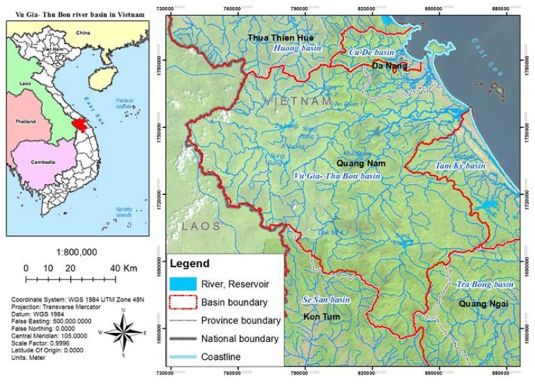
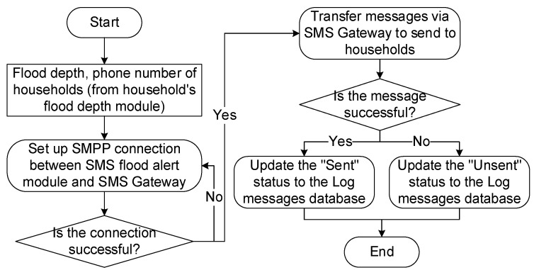
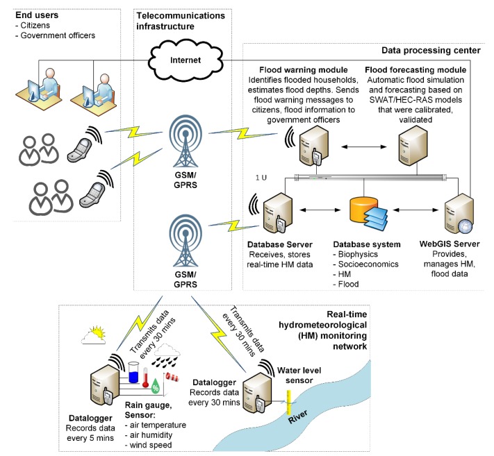
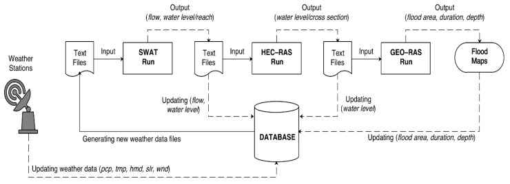
Vu Gia-Thu Bon (VGTB) river basin is an area where flash flood and heavy flood events occur frequently, negatively impacting the local community and socio-economic development of Quang Nam Province. In recent years, structural and non-structural solutions have been implemented to mitigate damages due to floods. However, under the impact of climate change, natural disasters continue to happen unpredictably day by day. It is, therefore, necessary to develop a spatial decision support system for real-time flood warnings in the VGTB river basin, which will support in ensuring the area's socio-economic development. The main purpose of this study is to develop an online flood warning system in real-time based on Internet-of-Things (IoT) technologies, GIS, telecommunications, and modeling (Soil and Water Assessment Tool (SWAT) and Hydrologic Engineering Center's River Analysis System (HEC-RAS)) in order to support the local community in the vulnerable downstream areas in the event of heavy rainfall upstream. The structure of the designed system consists of these following components: (1) real-time hydro-meteorological monitoring network, (2) IoT communication infrastructure (Global System for Mobile Communications (GSM), General Packet Radio Service (GPRS), wireless networks), (3) database management system (bio-physical, socio-economic, hydro-meteorological, and inundation), (4) simulating and predicting model (SWAT, HEC-RAS), (5) automated simulating and predicting module, (6) flood warning module via short message service (SMS), (7) WebGIS, application for providing and managing hydro-meteorological and inundation data, and (8) users (citizens and government officers). The entire operating processes of the flood warning system (i.e., hydro-meteorological data collecting, transferring, updating, processing, running SWAT and HEC-RAS, visualizing) are automated. A complete flood warning system for the VGTB river basin has been developed as an outcome of this study, which enables the prediction of flood events 5 h in advance and with high accuracy of 80%.

摘要

Vũ Gia-Thụy Bồn 流域是经常发生山洪和大洪水的地区,对广南省当地社区和社会经济发展造成负面影响。近年来,已经实施了结构和非结构措施来减轻洪水造成的破坏。然而,在气候变化的影响下,自然灾害仍在每天不可预测地发生。因此,有必要开发一个 Vũ Gia-Thụy Bồn 流域实时洪水预警空间决策支持系统,以支持该地区的社会经济发展。本研究的主要目的是基于物联网 (IoT) 技术、地理信息系统、电信和建模(土壤和水评估工具 (SWAT) 和水文工程中心的河流分析系统 (HEC-RAS))开发一个实时在线洪水预警系统,以便在暴雨上游时支持下游脆弱地区的当地社区。设计的系统结构由以下组件组成:(1) 实时水文气象监测网络,(2) IoT 通信基础设施(全球移动通信系统 (GSM)、通用分组无线电服务 (GPRS)、无线网络),(3) 数据库管理系统(生物物理、社会经济、水文气象和洪水淹没),(4) 模拟和预测模型(SWAT、HEC-RAS),(5) 自动化模拟和预测模块,(6) 通过短消息服务 (SMS) 的洪水预警模块,(7) WebGIS,用于提供和管理水文气象和洪水数据的应用程序,以及 (8) 用户(公民和政府官员)。洪水预警系统的整个运行过程(即水文气象数据收集、传输、更新、处理、运行 SWAT 和 HEC-RAS、可视化)都是自动化的。本研究开发了一个完整的 Vũ Gia-Thụy Bồn 流域洪水预警系统,可以提前 5 小时准确预测洪水事件,准确率达到 80%。

https://cdn.ncbi.nlm.nih.gov/pmc/blobs/0934/7147717/afdb0ac0d6e9/sensors-20-01667-g017.jpg
https://cdn.ncbi.nlm.nih.gov/pmc/blobs/0934/7147717/18ca877362cc/sensors-20-01667-g001.jpg
https://cdn.ncbi.nlm.nih.gov/pmc/blobs/0934/7147717/d38ad2a1aaa8/sensors-20-01667-g002.jpg
https://cdn.ncbi.nlm.nih.gov/pmc/blobs/0934/7147717/21e1113f24b5/sensors-20-01667-g003.jpg
https://cdn.ncbi.nlm.nih.gov/pmc/blobs/0934/7147717/3ca8cb773e65/sensors-20-01667-g004.jpg
https://cdn.ncbi.nlm.nih.gov/pmc/blobs/0934/7147717/953b1ef38be1/sensors-20-01667-g005.jpg
https://cdn.ncbi.nlm.nih.gov/pmc/blobs/0934/7147717/8a5d1c6c6bf0/sensors-20-01667-g006.jpg
https://cdn.ncbi.nlm.nih.gov/pmc/blobs/0934/7147717/f18c16ab7b49/sensors-20-01667-g007.jpg
https://cdn.ncbi.nlm.nih.gov/pmc/blobs/0934/7147717/1a7c95cca8ec/sensors-20-01667-g008.jpg
https://cdn.ncbi.nlm.nih.gov/pmc/blobs/0934/7147717/0eaf650b3ed5/sensors-20-01667-g009.jpg
https://cdn.ncbi.nlm.nih.gov/pmc/blobs/0934/7147717/80d0edbc19bc/sensors-20-01667-g010.jpg
https://cdn.ncbi.nlm.nih.gov/pmc/blobs/0934/7147717/c1afb7dbebc2/sensors-20-01667-g011.jpg
https://cdn.ncbi.nlm.nih.gov/pmc/blobs/0934/7147717/d5f1495444b8/sensors-20-01667-g012.jpg
https://cdn.ncbi.nlm.nih.gov/pmc/blobs/0934/7147717/823ce2e1348a/sensors-20-01667-g013.jpg
https://cdn.ncbi.nlm.nih.gov/pmc/blobs/0934/7147717/ae5e7182a721/sensors-20-01667-g014.jpg
https://cdn.ncbi.nlm.nih.gov/pmc/blobs/0934/7147717/cd51effeadb2/sensors-20-01667-g015.jpg
https://cdn.ncbi.nlm.nih.gov/pmc/blobs/0934/7147717/700a0526b08e/sensors-20-01667-g016.jpg
https://cdn.ncbi.nlm.nih.gov/pmc/blobs/0934/7147717/afdb0ac0d6e9/sensors-20-01667-g017.jpg

相似文献

1
Development of a Spatial Decision Support System for Real-Time Flood Early Warning in the Vu Gia-Thu Bon River Basin, Quang Nam Province, Vietnam.为越南广南省武佳-沱江流域开发实时洪水预警空间决策支持系统。
Sensors (Basel). 2020 Mar 17;20(6):1667. doi: 10.3390/s20061667.
2
Spatial appraisal of flood risk assessment and evaluation using integrated hydro-probabilistic approach in Panjkora River Basin, Pakistan.利用综合水文概率方法评估巴基斯坦潘杰科拉河流域的洪水风险及其空间评估。
Environ Monit Assess. 2019 Aug 17;191(9):573. doi: 10.1007/s10661-019-7746-z.
3
Combined top-down and bottom-up climate change impact assessment for the hydrological system in the Vu Gia- Thu Bon River Basin.对武佳-图邦河流域水文系统进行的自上而下和自下而上相结合的气候变化影响评估。
Sci Total Environ. 2018 Jul 15;630:718-727. doi: 10.1016/j.scitotenv.2018.02.250. Epub 2018 Feb 27.
4
Flood hazard delineation in an ungauged catchment by coupling hydrologic and hydraulic models with geospatial techniques-a case study of Koraiyar basin, Tiruchirappalli City, Tamil Nadu, India.利用水文和水力模型与地理空间技术对无测站集水区进行洪水灾害区划——以印度泰米尔纳德邦蒂鲁吉拉伯利市科赖亚尔流域为例。
Environ Monit Assess. 2020 Oct 8;192(11):689. doi: 10.1007/s10661-020-08650-2.
5
Quantifying the consequences of unsustainable sand mining and cascade dams on aspects in a tropical river basin.量化不可持续的采砂和梯级水坝对热带河流流域各方面的影响。
Sci Rep. 2024 Jan 12;14(1):1178. doi: 10.1038/s41598-024-51405-z.
6
ReAFFIRM: Real-time Assessment of Flash Flood Impacts - a Regional high-resolution Method.ReAFFIRM:实时评估洪水影响 - 一种区域高分辨率方法。
Environ Int. 2020 Mar;136:105375. doi: 10.1016/j.envint.2019.105375. Epub 2020 Jan 21.
7
Regional scale flood modeling using NEXRAD rainfall, GIS, and HEC-HMS/RAS: a case study for the San Antonio River Basin Summer 2002 storm event.利用NEXRAD降雨数据、地理信息系统(GIS)以及HEC-HMS/RAS进行区域尺度洪水建模:以2002年夏季圣安东尼奥河流域暴雨事件为例
J Environ Manage. 2005 Jun;75(4):325-36. doi: 10.1016/j.jenvman.2004.11.024.
8
Effectiveness assessment of reservoir projects for flash flood control, water supply and irrigation in Wangmo Basin, China.中国望谟流域水库工程在防洪、供水和灌溉方面的效益评估。
Sci Total Environ. 2022 Dec 10;851(Pt 2):157918. doi: 10.1016/j.scitotenv.2022.157918. Epub 2022 Aug 7.
9
An assessment of uncontrolled human interventions on the contemporary sediment budget and morphological alterations of the Vu Gia Thu Bon River basin, central Vietnam.越南中部武嘉-秋盆河流域当代泥沙收支与地貌变化的未受控制的人类干预评估。
Heliyon. 2024 May 28;10(11):e31476. doi: 10.1016/j.heliyon.2024.e31476. eCollection 2024 Jun 15.
10
Assessment of vulnerability to flood risk in the Padma River Basin using hydro-morphometric modeling and flood susceptibility mapping.利用水-形态计量建模和洪水易感性制图评估帕德玛河流域的洪水风险脆弱性。
Environ Monit Assess. 2024 Jun 25;196(7):661. doi: 10.1007/s10661-024-12780-2.

引用本文的文献

1
Identifying challenges and future directions of flood hazards mitigation strategies in health facilities: a systematic literature review.确定医疗机构洪水灾害缓解策略的挑战与未来方向:一项系统的文献综述
BMC Emerg Med. 2025 Sep 1;25(1):174. doi: 10.1186/s12873-025-01339-0.
2
Leveraging artificial intelligence in disaster management: A comprehensive bibliometric review.在灾害管理中利用人工智能:一项全面的文献计量学综述。
Jamba. 2025 Apr 7;17(1):1776. doi: 10.4102/jamba.v17i1.1776. eCollection 2025.
3
An assessment of uncontrolled human interventions on the contemporary sediment budget and morphological alterations of the Vu Gia Thu Bon River basin, central Vietnam.
越南中部武嘉-秋盆河流域当代泥沙收支与地貌变化的未受控制的人类干预评估。
Heliyon. 2024 May 28;10(11):e31476. doi: 10.1016/j.heliyon.2024.e31476. eCollection 2024 Jun 15.
4
The Application of SWAT Model and Remotely Sensed Products to Characterize the Dynamic of Streamflow and Snow in a Mountainous Watershed in the High Atlas.应用 SWAT 模型和遥感产品来描述高阿特拉斯山脉山区流域的水流和积雪动态。
Sensors (Basel). 2023 Jan 21;23(3):1246. doi: 10.3390/s23031246.
5
Starter Kit for Geotagging and Geovisualization in Health Care: Resource Paper.医疗保健中地理标记与地理可视化入门工具包:资源文件。
JMIR Form Res. 2020 Dec 24;4(12):e23379. doi: 10.2196/23379.