• 文献检索
  • 文档翻译
  • 深度研究
  • 学术资讯
  • Suppr Zotero 插件Zotero 插件
  • 邀请有礼
  • 套餐&价格
  • 历史记录
应用&插件
Suppr Zotero 插件Zotero 插件浏览器插件Mac 客户端Windows 客户端微信小程序
定价
高级版会员购买积分包购买API积分包
服务
文献检索文档翻译深度研究API 文档MCP 服务
关于我们
关于 Suppr公司介绍联系我们用户协议隐私条款
关注我们

Suppr 超能文献

核心技术专利:CN118964589B侵权必究
粤ICP备2023148730 号-1Suppr @ 2026

文献检索

告别复杂PubMed语法,用中文像聊天一样搜索,搜遍4000万医学文献。AI智能推荐,让科研检索更轻松。

立即免费搜索

文件翻译

保留排版,准确专业,支持PDF/Word/PPT等文件格式,支持 12+语言互译。

免费翻译文档

深度研究

AI帮你快速写综述,25分钟生成高质量综述,智能提取关键信息,辅助科研写作。

立即免费体验

通过 MDLSTM 预测和解释空间事故。

Predicting and Interpreting Spatial Accidents through MDLSTM.

机构信息

Institute of Transportation Engineering and Geomatics, Tsinghua University, Beijing 100084, China.

Division of Biosciences, University College London, London WC1E 6BT, UK.

出版信息

Int J Environ Res Public Health. 2021 Feb 3;18(4):1430. doi: 10.3390/ijerph18041430.

DOI:10.3390/ijerph18041430
PMID:33546503
原文链接:https://pmc.ncbi.nlm.nih.gov/articles/PMC7913614/
Abstract

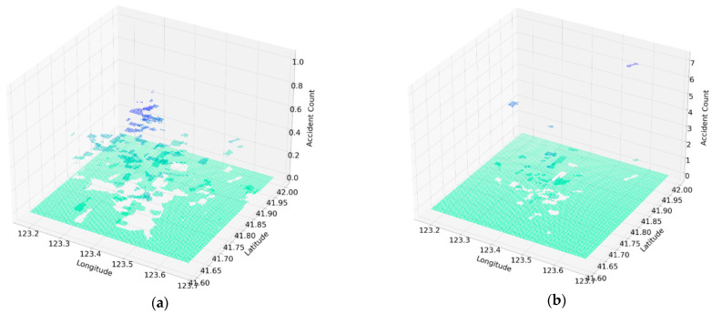
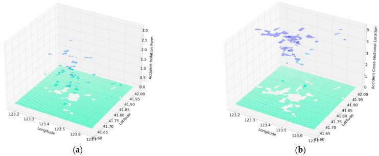
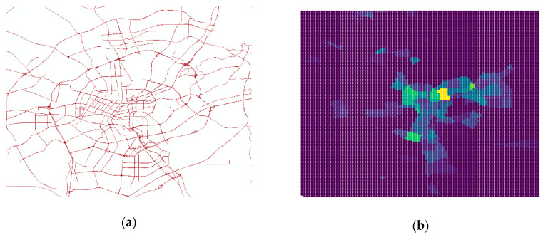
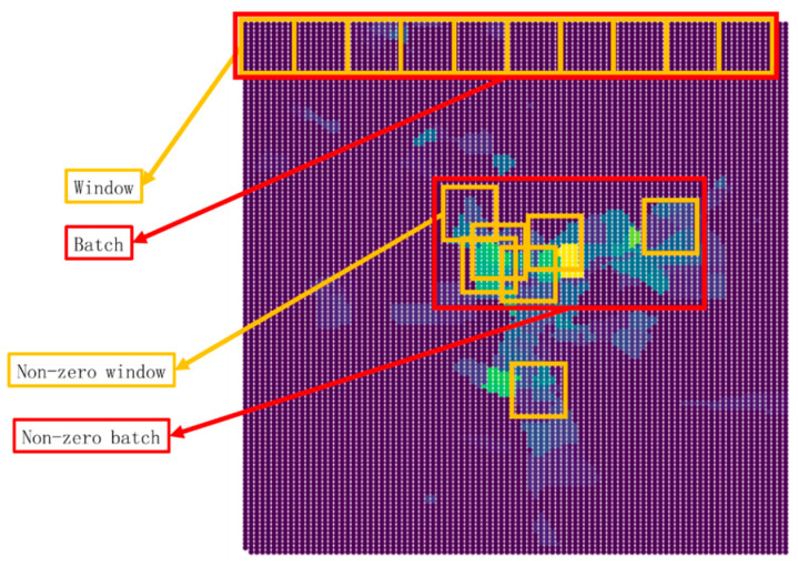
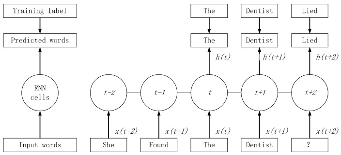
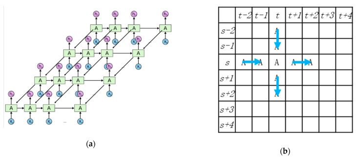
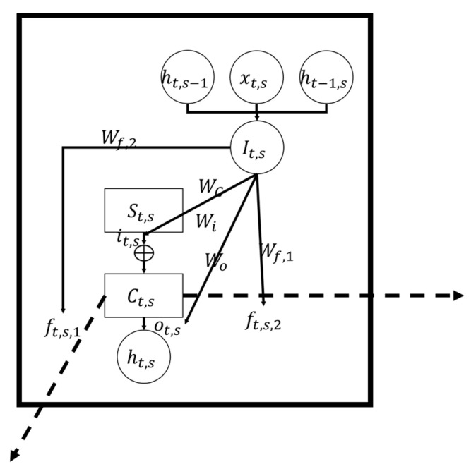
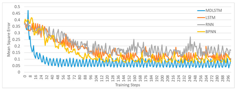
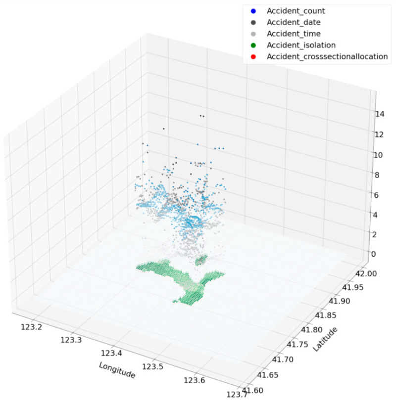
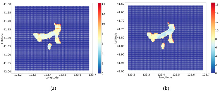
Predicting and interpreting the spatial location and causes of traffic accidents is one of the current hot topics in traffic safety. This research purposed a multi-dimensional long-short term memory neural network model (MDLSTM) to fit the non-linear relationships between traffic accident characteristics and land use properties, which are further interpreted to form local and general rules. More variables are taken into account as the input land use properties and the output traffic accident characteristics. Five types of traffic accident characteristics are simultaneously predicted with higher accuracy, and three levels of interpretation, including the hidden factor-traffic potential, the potential-determine factors, which varies between grid cells, and the general rules across the whole study area are analyzed. Based on the model, some interesting insights were revealed including the division line in the potential traffic accidents in Shenyang (China). It is also purposed that the relationship between land use and accidents differ from previous researches in the neighboring and regional aspects. Neighboring grids have strong spatial connections so that the relationship of accidents in a continuous area is relatively similar. In a larger region, the spatial location is found to have a great influence on the traffic accident and has a strong directionality.

摘要

预测和解释交通事故的空间位置和原因是当前交通安全领域的热门话题之一。本研究提出了一种多维长短时记忆神经网络模型(MDLSTM),以拟合交通事故特征与土地利用属性之间的非线性关系,并进一步解释形成局部和一般规则。更多的变量被视为输入的土地利用属性和输出的交通事故特征。该模型能够更准确地同时预测五种类型的交通事故特征,并分析了三个层次的解释,包括隐藏因素——交通潜力、在网格单元之间变化的潜力决定因素以及整个研究区域的一般规则。基于该模型,揭示了一些有趣的见解,包括在中国沈阳潜在交通事故的分界线。还提出了土地利用与事故之间的关系在邻域和区域方面与以往研究不同。相邻的网格具有很强的空间连接,因此连续区域的事故关系相对相似。在更大的区域中,空间位置被发现对交通事故有很大的影响,并且具有很强的方向性。

https://cdn.ncbi.nlm.nih.gov/pmc/blobs/4676/7913614/2fed3f723ac5/ijerph-18-01430-g013.jpg
https://cdn.ncbi.nlm.nih.gov/pmc/blobs/4676/7913614/3e377e1956f8/ijerph-18-01430-g001.jpg
https://cdn.ncbi.nlm.nih.gov/pmc/blobs/4676/7913614/9e46d44e487e/ijerph-18-01430-g002.jpg
https://cdn.ncbi.nlm.nih.gov/pmc/blobs/4676/7913614/8f1944c5edb6/ijerph-18-01430-g003.jpg
https://cdn.ncbi.nlm.nih.gov/pmc/blobs/4676/7913614/3c8e35704ce5/ijerph-18-01430-g004.jpg
https://cdn.ncbi.nlm.nih.gov/pmc/blobs/4676/7913614/3b60a2d3b285/ijerph-18-01430-g005.jpg
https://cdn.ncbi.nlm.nih.gov/pmc/blobs/4676/7913614/683a4cc1c27e/ijerph-18-01430-g006.jpg
https://cdn.ncbi.nlm.nih.gov/pmc/blobs/4676/7913614/658ab04385a5/ijerph-18-01430-g007.jpg
https://cdn.ncbi.nlm.nih.gov/pmc/blobs/4676/7913614/d087a6372a4a/ijerph-18-01430-g008.jpg
https://cdn.ncbi.nlm.nih.gov/pmc/blobs/4676/7913614/12f1bf06ac75/ijerph-18-01430-g009.jpg
https://cdn.ncbi.nlm.nih.gov/pmc/blobs/4676/7913614/95ac81ba94fb/ijerph-18-01430-g010.jpg
https://cdn.ncbi.nlm.nih.gov/pmc/blobs/4676/7913614/b6a77723d16a/ijerph-18-01430-g011.jpg
https://cdn.ncbi.nlm.nih.gov/pmc/blobs/4676/7913614/2839eeca694e/ijerph-18-01430-g012.jpg
https://cdn.ncbi.nlm.nih.gov/pmc/blobs/4676/7913614/2fed3f723ac5/ijerph-18-01430-g013.jpg

相似文献

1
Predicting and Interpreting Spatial Accidents through MDLSTM.通过 MDLSTM 预测和解释空间事故。
Int J Environ Res Public Health. 2021 Feb 3;18(4):1430. doi: 10.3390/ijerph18041430.
2
Factors influencing traffic accident frequencies on urban roads: A spatial panel time-fixed effects error model.影响城市道路交通事故频率的因素:空间面板时间固定效应误差模型。
PLoS One. 2019 Apr 4;14(4):e0214539. doi: 10.1371/journal.pone.0214539. eCollection 2019.
3
Spatial analysis of traffic accidents near and between road intersections in a directed linear network.有向线性网络中道路交叉口附近和之间的交通事故空间分析。
Accid Anal Prev. 2019 Nov;132:105252. doi: 10.1016/j.aap.2019.07.028. Epub 2019 Aug 19.
4
Traffic Accident Data Generation Based on Improved Generative Adversarial Networks.基于改进生成对抗网络的交通事故数据生成。
Sensors (Basel). 2021 Aug 27;21(17):5767. doi: 10.3390/s21175767.
5
Spatial influence of engineering construction on traffic accidents, a case study of Jinan.工程建设对交通事故的空间影响——以济南市为例。
Accid Anal Prev. 2022 Nov;177:106825. doi: 10.1016/j.aap.2022.106825. Epub 2022 Sep 6.
6
Toward safer highways, application of XGBoost and SHAP for real-time accident detection and feature analysis.为了更安全的高速公路,应用 XGBoost 和 SHAP 进行实时事故检测和特征分析。
Accid Anal Prev. 2020 Mar;136:105405. doi: 10.1016/j.aap.2019.105405. Epub 2019 Dec 20.
7
Spatial analysis of driving accidents leading to deaths related to motorcyclists in Tehran.德黑兰导致摩托车手死亡的交通事故的空间分析。
Chin J Traumatol. 2019 Jun;22(3):148-154. doi: 10.1016/j.cjtee.2018.12.006. Epub 2019 Apr 6.
8
Real-time traffic accidents post-impact prediction: Based on crowdsourcing data.实时交通事故碰撞后预测:基于众包数据。
Accid Anal Prev. 2020 Sep;145:105696. doi: 10.1016/j.aap.2020.105696. Epub 2020 Jul 21.
9
The Big Data Model for Urban Road Land Use Planning Is Based on a Neural Network Algorithm.基于神经网络算法的城市道路用地规划大数据模型。
Comput Intell Neurosci. 2022 Sep 13;2022:2727512. doi: 10.1155/2022/2727512. eCollection 2022.
10
Road traffic accident severity analysis: A census-based study in China.道路交通事故严重程度分析:基于普查的中国研究。
J Safety Res. 2019 Sep;70:135-147. doi: 10.1016/j.jsr.2019.06.002. Epub 2019 Jul 4.

引用本文的文献

1
GATR: A Road Network Traffic Violation Prediction Method Based on Graph Attention Network.基于图注意力网络的道路网络交通违规预测方法(GATR)
Int J Environ Res Public Health. 2023 Feb 15;20(4):3432. doi: 10.3390/ijerph20043432.

本文引用的文献

1
A multivariate analysis of environmental effects on road accident occurrence using a balanced bagging approach.运用平衡套袋法对道路交通事故发生的环境影响进行多元分析。
Accid Anal Prev. 2020 Mar;136:105398. doi: 10.1016/j.aap.2019.105398. Epub 2019 Dec 17.
2
Exploring injury severity in head-on crashes using latent class clustering analysis and mixed logit model: A case study of North Carolina.利用潜在类别聚类分析和混合逻辑回归模型探讨正面碰撞中的伤害严重程度:以北卡罗来纳州为例的研究
Accid Anal Prev. 2020 Feb;135:105388. doi: 10.1016/j.aap.2019.105388. Epub 2019 Dec 5.
3
A review of spatial approaches in road safety.
道路安全空间方法综述。
Accid Anal Prev. 2020 Feb;135:105323. doi: 10.1016/j.aap.2019.105323. Epub 2019 Oct 22.
4
Associations between upper extremity injury patterns in side impact motor vehicle collisions with occupant and crash characteristics.侧面碰撞机动车事故中乘客上肢损伤类型与事故特征的关联。
Accid Anal Prev. 2019 Jan;122:1-7. doi: 10.1016/j.aap.2018.09.029. Epub 2018 Oct 5.
5
Effects of truck traffic on crash injury severity on rural highways in Wyoming using Bayesian binary logit models.怀俄明州农村公路上卡车交通对碰撞伤害严重程度的影响:基于贝叶斯二项逻辑回归模型的研究。
Accid Anal Prev. 2018 Aug;117:106-113. doi: 10.1016/j.aap.2018.04.011. Epub 2018 May 2.
6
Analysis of passenger-car crash injury severity in different work zone configurations.不同工作区配置下乘用车碰撞伤害严重程度分析。
Accid Anal Prev. 2018 Feb;111:161-172. doi: 10.1016/j.aap.2017.11.026. Epub 2017 Dec 5.
7
Do safety performance functions used for predicting crash frequency vary across space? Applying geographically weighted regressions to account for spatial heterogeneity.安全性能函数用于预测碰撞频率是否因空间而异?应用地理加权回归来考虑空间异质性。
Accid Anal Prev. 2017 Dec;109:132-142. doi: 10.1016/j.aap.2017.10.012. Epub 2017 Oct 21.
8
Predicting motorcycle crash injury severity using weather data and alternative Bayesian multivariate crash frequency models.利用天气数据和替代贝叶斯多元碰撞频率模型预测摩托车碰撞伤害严重程度。
Accid Anal Prev. 2017 Nov;108:172-180. doi: 10.1016/j.aap.2017.08.032. Epub 2017 Sep 6.
9
Macroscopic hotspots identification: A Bayesian spatio-temporal interaction approach.宏观热点识别:一种基于贝叶斯时空交互的方法。
Accid Anal Prev. 2016 Jul;92:256-64. doi: 10.1016/j.aap.2016.04.001. Epub 2016 Apr 23.
10
Road network safety evaluation using Bayesian hierarchical joint model.使用贝叶斯分层联合模型的道路网络安全评估
Accid Anal Prev. 2016 May;90:152-8. doi: 10.1016/j.aap.2016.02.018. Epub 2016 Mar 2.