Martines M R, Ferreira R V, Toppa R H, Assunção L M, Desjardins M R, Delmelle E M
Department of Geography, Tourism and Humanities, Research Group: Center for Studies in Landscape Ecology and Conservation, Federal University of São Carlos, Sorocaba, SP Brazil.
Department of Geography, Research Group: Center for Studies in Landscape Ecology and Conservation, Federal University of Triângulo Mineiro, Uberaba Campus, State of Minas Gerais Brazil.
J Geogr Syst. 2021;23(1):7-36. doi: 10.1007/s10109-020-00344-0. Epub 2021 Mar 8.
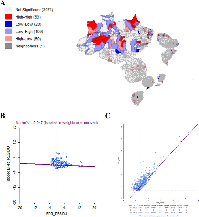
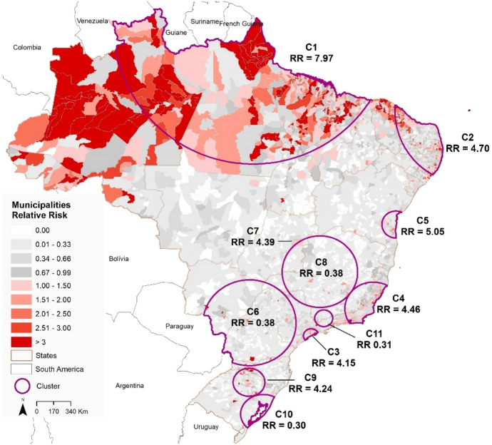
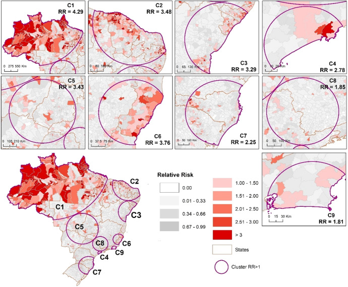
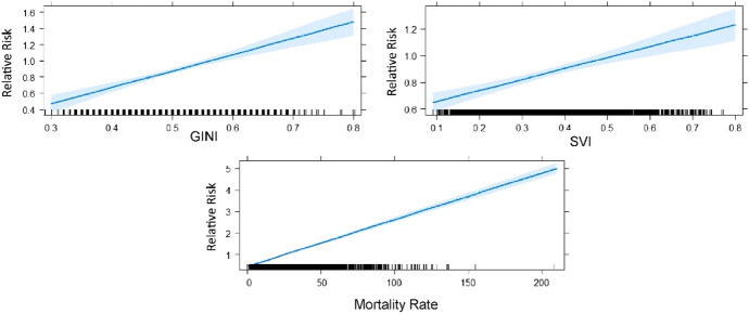
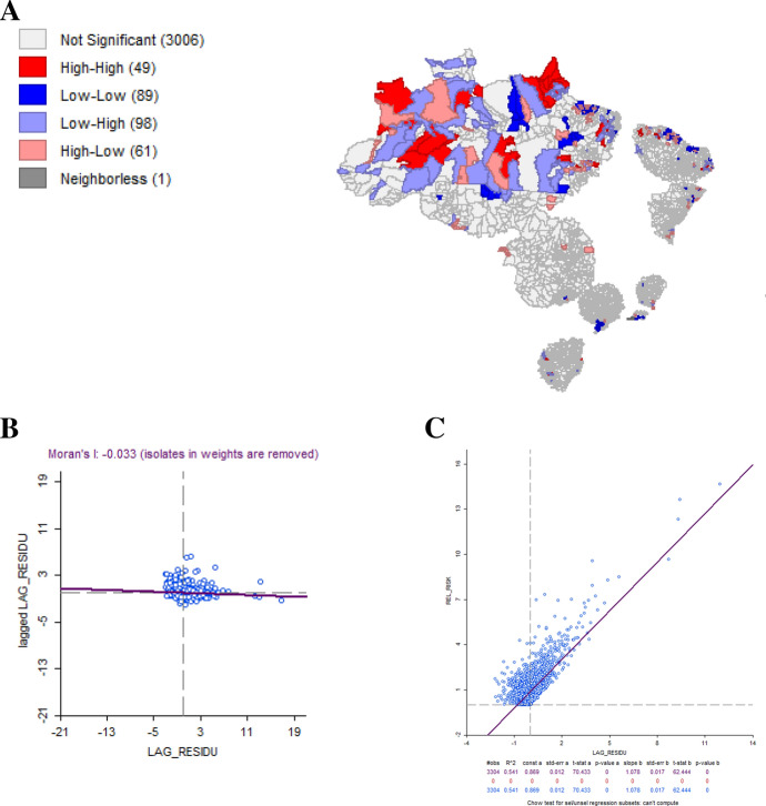
The first case of COVID-19 in South America occurred in Brazil on February 25, 2020. By July 20, 2020, there were 2,118,646 confirmed cases and 80,120 confirmed deaths. To assist with the development of preventive measures and targeted interventions to combat the pandemic in Brazil, we present a geographic study to detect "active" and "emerging" space-time clusters of COVID-19. We document the relationship between relative risk of COVID-19 and mortality, inequality, socioeconomic vulnerability variables. We used the prospective space-time scan statistic to detect daily COVID-19 clusters and examine the relative risk between February 25-June 7, 2020, and February 25-July 20, 2020, in 5570 Brazilian municipalities. We apply a Generalized Linear Model (GLM) to assess whether mortality rate, GINI index, and social inequality are predictors for the relative risk of each cluster. We detected 7 "active" clusters in the first time period, being one in the north, two in the northeast, two in the southeast, one in the south, and one in the capital of Brazil. In the second period, we found 9 clusters with RR > 1 located in all Brazilian regions. The results obtained through the GLM showed that there is a significant positive correlation between the predictor variables in relation to the relative risk of COVID-19. Given the presence of spatial autocorrelation in the GLM residuals, a spatial lag model was conducted that revealed that spatial effects, and both GINI index and mortality rate were strong predictors in the increase in COVID-19 relative risk in Brazil. Our research can be utilized to improve COVID-19 response and planning in all Brazilian states. The results from this study are particularly salient to public health, as they can guide targeted intervention measures, lowering the magnitude and spread of COVID-19. They can also improve resource allocation such as tests and vaccines (when available) by informing key public health officials about the highest risk areas of COVID-19.
2020年2月25日,南美洲首例新冠肺炎病例在巴西出现。截至2020年7月20日,巴西累计确诊病例达2118646例,确诊死亡病例80120例。为助力巴西制定预防措施及针对性干预措施以抗击疫情,我们开展了一项地理研究,以检测新冠肺炎的“活跃”和“新兴”时空聚集情况。我们记录了新冠肺炎相对风险与死亡率、不平等、社会经济脆弱性变量之间的关系。我们使用前瞻性时空扫描统计量来检测每日新冠肺炎聚集情况,并考察了2020年2月25日至6月7日以及2020年2月25日至7月20日期间巴西5570个市的相对风险。我们应用广义线性模型(GLM)来评估死亡率、基尼系数和社会不平等是否为每个聚集区相对风险的预测因素。在第一个时间段,我们检测到7个“活跃”聚集区,其中1个在北部,2个在东北部,2个在东南部,1个在南部,1个在巴西首都。在第二个时间段,我们发现9个相对风险大于1的聚集区,分布在巴西所有地区。通过广义线性模型得到的结果表明,预测变量与新冠肺炎相对风险之间存在显著正相关。鉴于广义线性模型残差中存在空间自相关,我们进行了空间滞后模型分析,结果显示空间效应以及基尼系数和死亡率都是巴西新冠肺炎相对风险增加的有力预测因素。我们的研究可用于改进巴西所有州对新冠肺炎的应对和规划。本研究结果对公共卫生尤为重要,因为它们可指导针对性干预措施,降低新冠肺炎的规模和传播。这些结果还可通过向关键公共卫生官员通报新冠肺炎风险最高的地区,改善检测和疫苗(如有)等资源的分配。