• 文献检索
  • 文档翻译
  • 深度研究
  • 学术资讯
  • Suppr Zotero 插件Zotero 插件
  • 邀请有礼
  • 套餐&价格
  • 历史记录
应用&插件
Suppr Zotero 插件Zotero 插件浏览器插件Mac 客户端Windows 客户端微信小程序
定价
高级版会员购买积分包购买API积分包
服务
文献检索文档翻译深度研究API 文档MCP 服务
关于我们
关于 Suppr公司介绍联系我们用户协议隐私条款
关注我们

Suppr 超能文献

核心技术专利:CN118964589B侵权必究
粤ICP备2023148730 号-1Suppr @ 2026

文献检索

告别复杂PubMed语法,用中文像聊天一样搜索,搜遍4000万医学文献。AI智能推荐,让科研检索更轻松。

立即免费搜索

文件翻译

保留排版,准确专业,支持PDF/Word/PPT等文件格式,支持 12+语言互译。

免费翻译文档

深度研究

AI帮你快速写综述,25分钟生成高质量综述,智能提取关键信息,辅助科研写作。

立即免费体验

基于 WebGIS 和机器学习模型的自动化滑坡风险预测

Automated Landslide-Risk Prediction Using Web GIS and Machine Learning Models.

机构信息

School of Software Engineering, Payap University, Chiang Mai 50000, Thailand.

Department of Computer and Information Sciences, Northumbria University, Newcastle upon Tyne NE1 8ST, UK.

出版信息

Sensors (Basel). 2021 Jul 5;21(13):4620. doi: 10.3390/s21134620.

DOI:10.3390/s21134620
PMID:34283153
原文链接:https://pmc.ncbi.nlm.nih.gov/articles/PMC8271927/
Abstract

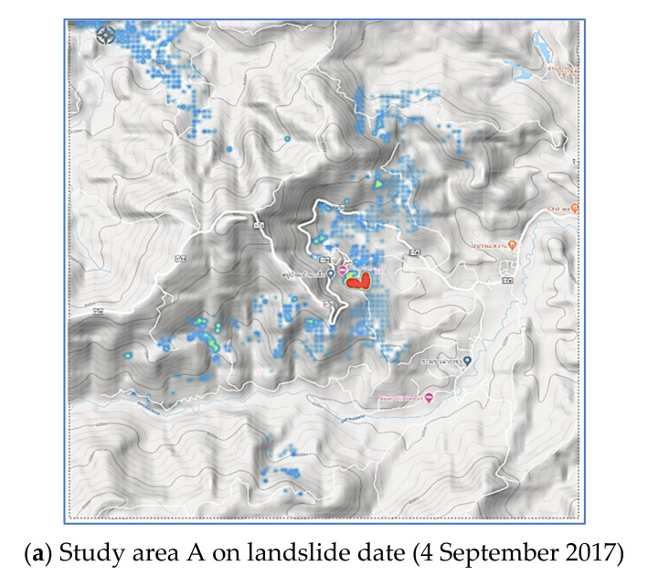
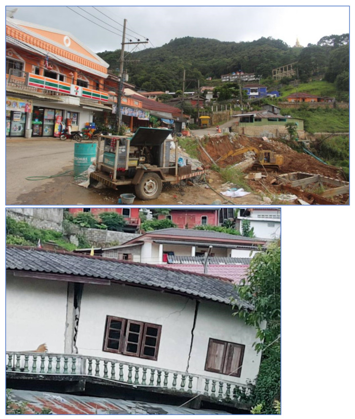
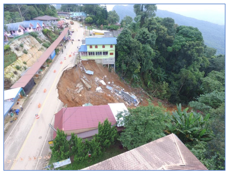
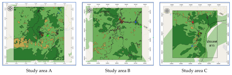
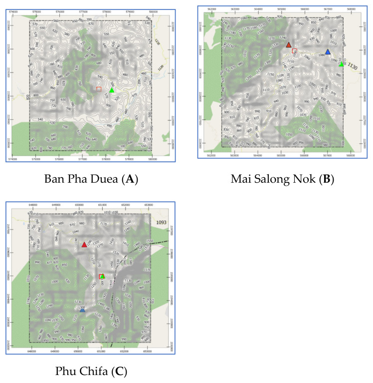
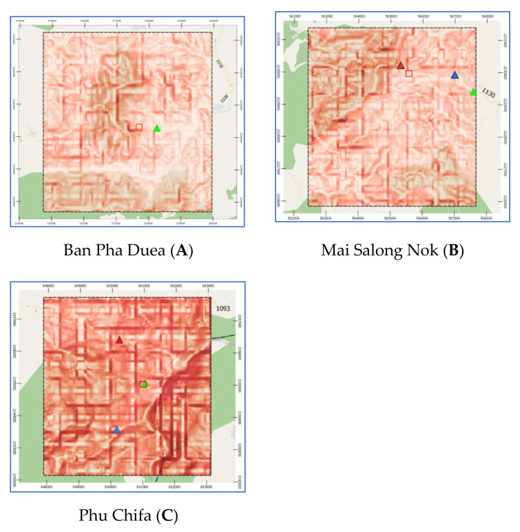
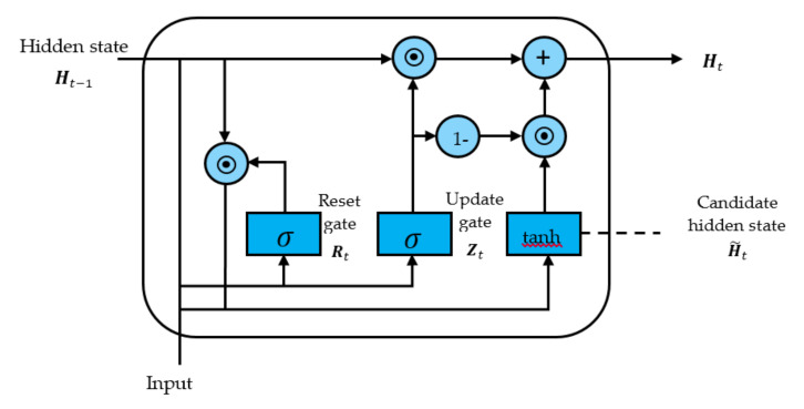
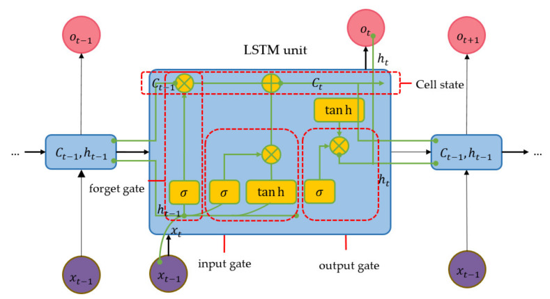
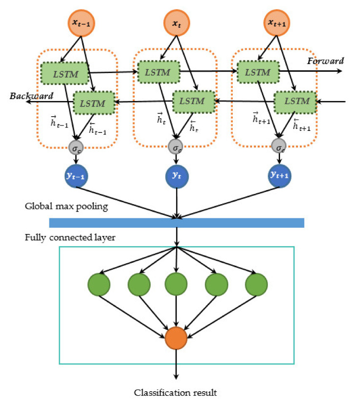
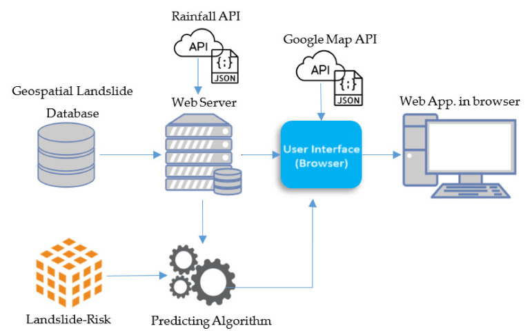
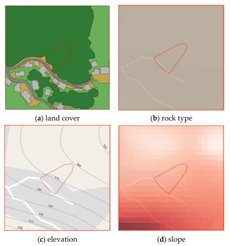
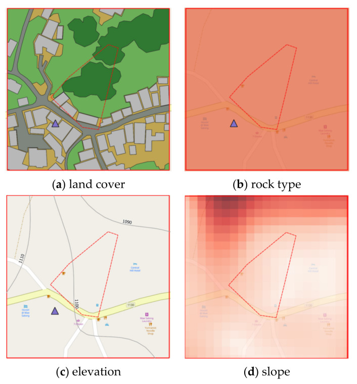
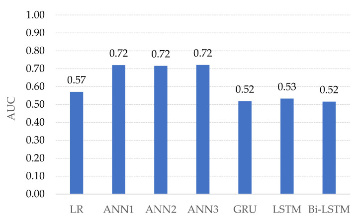
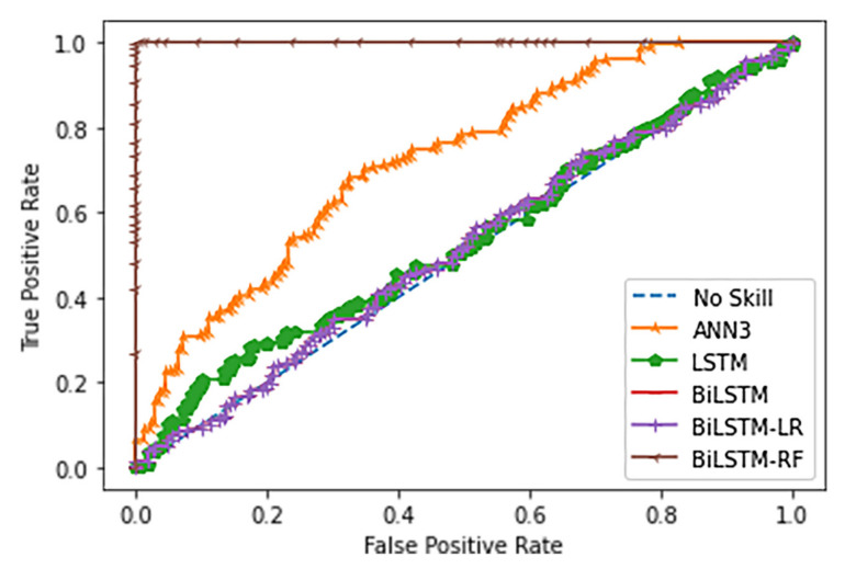
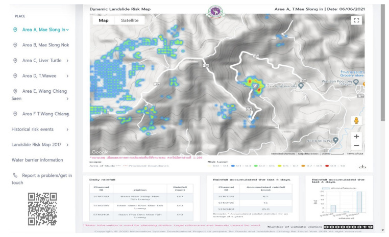
Spatial susceptible landslide prediction is the one of the most challenging research areas which essentially concerns the safety of inhabitants. The novel geographic information web (GIW) application is proposed for dynamically predicting landslide risk in Chiang Rai, Thailand. The automated GIW system is coordinated between machine learning technologies, web technologies, and application programming interfaces (APIs). The new bidirectional long short-term memory (Bi-LSTM) algorithm is presented to forecast landslides. The proposed algorithm consists of 3 major steps, the first of which is the construction of a landslide dataset by using Quantum GIS (QGIS). The second step is to generate the landslide-risk model based on machine learning approaches. Finally, the automated landslide-risk visualization illustrates the likelihood of landslide via Google Maps on the website. Four static factors are considered for landslide-risk prediction, namely, land cover, soil properties, elevation and slope, and a single dynamic factor i.e., precipitation. Data are collected to construct a geospatial landslide database which comprises three historical landslide locations-Phu Chifa at Thoeng District, Ban Pha Duea at Mae Salong Nai, and Mai Salong Nok in Mae Fa Luang District, Chiang Rai, Thailand. Data collection is achieved using QGIS software to interpolate contour, elevation, slope degree and land cover from the Google satellite images, aerial and site survey photographs while the physiographic and rock type are on-site surveyed by experts. The state-of-the-art machine learning models have been trained i.e., linear regression (LR), artificial neural network (ANN), LSTM, and Bi-LSTM. Ablation studies have been conducted to determine the optimal parameters setting for each model. An enhancement method based on two-stage classifications has been presented to improve the landslide prediction of LSTM and Bi-LSTM models. The landslide-risk prediction performances of these models are subsequently evaluated using real-time dataset and it is shown that Bi-LSTM with Random Forest (Bi-LSTM-RF) yields the best prediction performance. Bi-LSTM-RF model has improved the landslide-risk predicting performance over LR, ANNs, LSTM, and Bi-LSTM in terms of the area under the receiver characteristic operator (AUC) scores by 0.42, 0.27, 0.46, and 0.47, respectively. Finally, an automated web GIS has been developed and it consists of software components including the trained models, rainfall API, Google API, and geodatabase. All components have been interfaced together via JavaScript and Node.js tool.

摘要

空间易发性滑坡预测是最具挑战性的研究领域之一,它本质上关系到居民的安全。提出了一种新的地理信息网络(GIW)应用程序,用于动态预测泰国清莱的滑坡风险。自动化 GIW 系统通过机器学习技术、网络技术和应用程序编程接口(API)进行协调。提出了一种新的双向长短期记忆(Bi-LSTM)算法来预测滑坡。该算法由 3 个主要步骤组成,第一步是使用 Quantum GIS(QGIS)构建滑坡数据集。第二步是基于机器学习方法生成滑坡风险模型。最后,通过网站上的 Google Maps 自动可视化滑坡风险,说明滑坡的可能性。为了预测滑坡风险,考虑了 4 个静态因素,即土地覆盖、土壤特性、海拔和坡度,以及一个单一的动态因素,即降水。收集数据以构建一个地理空间滑坡数据库,其中包括泰国清莱 Thoeng 区的 Phu Chifa、Mae Salong Nai 的 Ban Pha Duea 和 Mai Salong Nok 三个历史滑坡位置。使用 QGIS 软件收集数据,从 Google 卫星图像、航空和现场调查照片中插值等高线、海拔、坡度和土地覆盖,而地貌和岩石类型则由专家现场调查。已经训练了最先进的机器学习模型,即线性回归(LR)、人工神经网络(ANN)、LSTM 和 Bi-LSTM。进行了消融研究,以确定每个模型的最佳参数设置。提出了一种基于两阶段分类的增强方法,以提高 LSTM 和 Bi-LSTM 模型的滑坡预测能力。随后使用实时数据集评估这些模型的滑坡风险预测性能,结果表明 Bi-LSTM 与随机森林(Bi-LSTM-RF)的预测性能最好。Bi-LSTM-RF 模型在面积下的接收者特征运算符(AUC)得分方面,分别比 LR、ANNs、LSTM 和 Bi-LSTM 提高了 0.42、0.27、0.46 和 0.47,提高了滑坡风险预测性能。最后,开发了一个自动化的网络 GIS,它由软件组件组成,包括训练模型、降雨 API、Google API 和地理数据库。所有组件都通过 JavaScript 和 Node.js 工具进行了接口连接。

https://cdn.ncbi.nlm.nih.gov/pmc/blobs/e5e5/8271927/beab0daf4abd/sensors-21-04620-g034a.jpg
https://cdn.ncbi.nlm.nih.gov/pmc/blobs/e5e5/8271927/f5ef45f8fa00/sensors-21-04620-g001.jpg
https://cdn.ncbi.nlm.nih.gov/pmc/blobs/e5e5/8271927/b9206ea60da4/sensors-21-04620-g002.jpg
https://cdn.ncbi.nlm.nih.gov/pmc/blobs/e5e5/8271927/bf36222321e2/sensors-21-04620-g003.jpg
https://cdn.ncbi.nlm.nih.gov/pmc/blobs/e5e5/8271927/c5a71c4cb932/sensors-21-04620-g004.jpg
https://cdn.ncbi.nlm.nih.gov/pmc/blobs/e5e5/8271927/4788566825c3/sensors-21-04620-g005.jpg
https://cdn.ncbi.nlm.nih.gov/pmc/blobs/e5e5/8271927/442533f851d4/sensors-21-04620-g006.jpg
https://cdn.ncbi.nlm.nih.gov/pmc/blobs/e5e5/8271927/ef0eb9070c81/sensors-21-04620-g007.jpg
https://cdn.ncbi.nlm.nih.gov/pmc/blobs/e5e5/8271927/8dc07deeaf67/sensors-21-04620-g008.jpg
https://cdn.ncbi.nlm.nih.gov/pmc/blobs/e5e5/8271927/2aa2e3169f28/sensors-21-04620-g009.jpg
https://cdn.ncbi.nlm.nih.gov/pmc/blobs/e5e5/8271927/f021bd6baf56/sensors-21-04620-g010.jpg
https://cdn.ncbi.nlm.nih.gov/pmc/blobs/e5e5/8271927/8086e702f474/sensors-21-04620-g011.jpg
https://cdn.ncbi.nlm.nih.gov/pmc/blobs/e5e5/8271927/84800f9586d3/sensors-21-04620-g012.jpg
https://cdn.ncbi.nlm.nih.gov/pmc/blobs/e5e5/8271927/7f488e40295a/sensors-21-04620-g013.jpg
https://cdn.ncbi.nlm.nih.gov/pmc/blobs/e5e5/8271927/98dc717adf6e/sensors-21-04620-g014.jpg
https://cdn.ncbi.nlm.nih.gov/pmc/blobs/e5e5/8271927/541eb6b37f29/sensors-21-04620-g015.jpg
https://cdn.ncbi.nlm.nih.gov/pmc/blobs/e5e5/8271927/563a5e3d38a1/sensors-21-04620-g016.jpg
https://cdn.ncbi.nlm.nih.gov/pmc/blobs/e5e5/8271927/b0895f2902c5/sensors-21-04620-g017.jpg
https://cdn.ncbi.nlm.nih.gov/pmc/blobs/e5e5/8271927/eea4abcb05db/sensors-21-04620-g018.jpg
https://cdn.ncbi.nlm.nih.gov/pmc/blobs/e5e5/8271927/40ce63728d90/sensors-21-04620-g019.jpg
https://cdn.ncbi.nlm.nih.gov/pmc/blobs/e5e5/8271927/bd0bbd31e2b9/sensors-21-04620-g020.jpg
https://cdn.ncbi.nlm.nih.gov/pmc/blobs/e5e5/8271927/998dcfd65f83/sensors-21-04620-g021.jpg
https://cdn.ncbi.nlm.nih.gov/pmc/blobs/e5e5/8271927/4c87894fd38d/sensors-21-04620-g022.jpg
https://cdn.ncbi.nlm.nih.gov/pmc/blobs/e5e5/8271927/20e1ca8da084/sensors-21-04620-g023.jpg
https://cdn.ncbi.nlm.nih.gov/pmc/blobs/e5e5/8271927/8fe3848b8317/sensors-21-04620-g024.jpg
https://cdn.ncbi.nlm.nih.gov/pmc/blobs/e5e5/8271927/a88e8f60c1dd/sensors-21-04620-g025.jpg
https://cdn.ncbi.nlm.nih.gov/pmc/blobs/e5e5/8271927/77db41974664/sensors-21-04620-g026.jpg
https://cdn.ncbi.nlm.nih.gov/pmc/blobs/e5e5/8271927/55987fc9d797/sensors-21-04620-g027.jpg
https://cdn.ncbi.nlm.nih.gov/pmc/blobs/e5e5/8271927/31b03bcd86bb/sensors-21-04620-g028.jpg
https://cdn.ncbi.nlm.nih.gov/pmc/blobs/e5e5/8271927/1369a1f86577/sensors-21-04620-g029.jpg
https://cdn.ncbi.nlm.nih.gov/pmc/blobs/e5e5/8271927/2b3d9667f9fd/sensors-21-04620-g030.jpg
https://cdn.ncbi.nlm.nih.gov/pmc/blobs/e5e5/8271927/1ca3b9d583dd/sensors-21-04620-g031.jpg
https://cdn.ncbi.nlm.nih.gov/pmc/blobs/e5e5/8271927/16f453cfcc9c/sensors-21-04620-g032.jpg
https://cdn.ncbi.nlm.nih.gov/pmc/blobs/e5e5/8271927/51d90a3ace5f/sensors-21-04620-g033.jpg
https://cdn.ncbi.nlm.nih.gov/pmc/blobs/e5e5/8271927/beab0daf4abd/sensors-21-04620-g034a.jpg

相似文献

1
Automated Landslide-Risk Prediction Using Web GIS and Machine Learning Models.基于 WebGIS 和机器学习模型的自动化滑坡风险预测
Sensors (Basel). 2021 Jul 5;21(13):4620. doi: 10.3390/s21134620.
2
Optimizing the Predictive Ability of Machine Learning Methods for Landslide Susceptibility Mapping Using SMOTE for Lishui City in Zhejiang Province, China.利用 SMOTE 优化机器学习方法在浙江省丽水市滑坡易发性制图中的预测能力。
Int J Environ Res Public Health. 2019 Jan 28;16(3):368. doi: 10.3390/ijerph16030368.
3
Rainfall-Induced Landslide Prediction Using Machine Learning Models: The Case of Ngororero District, Rwanda.基于机器学习模型的降雨诱发滑坡预测:以卢旺达恩戈罗恩戈罗区为例。
Int J Environ Res Public Health. 2020 Jun 10;17(11):4147. doi: 10.3390/ijerph17114147.
4
A novel evolutionary combination of artificial intelligence algorithm and machine learning for landslide susceptibility mapping in the west of Iran.一种新型的人工智能算法和机器学习的进化组合,用于伊朗西部的滑坡易发性制图。
Environ Sci Pollut Res Int. 2023 Dec;30(59):123527-123555. doi: 10.1007/s11356-023-30762-8. Epub 2023 Nov 21.
5
Exploring machine learning and statistical approach techniques for landslide susceptibility mapping in Siwalik Himalayan Region using geospatial technology.利用地理空间技术探索机器学习和统计方法在喜马拉雅山西瓦利克地区进行滑坡敏感性制图。
Environ Sci Pollut Res Int. 2024 Feb;31(7):10443-10459. doi: 10.1007/s11356-023-31670-7. Epub 2024 Jan 10.
6
Comparison of Random Forest Model and Frequency Ratio Model for Landslide Susceptibility Mapping (LSM) in Yunyang County (Chongqing, China).随机森林模型与频率比模型在渝阳区(中国重庆)滑坡易发性制图(LSM)中的比较。
Int J Environ Res Public Health. 2020 Jun 12;17(12):4206. doi: 10.3390/ijerph17124206.
7
Landslide Susceptibility Prediction Modeling Based on Remote Sensing and a Novel Deep Learning Algorithm of a Cascade-Parallel Recurrent Neural Network.基于遥感和级联并行循环神经网络新型深度学习算法的滑坡易发性预测建模。
Sensors (Basel). 2020 Mar 12;20(6):1576. doi: 10.3390/s20061576.
8
Using Complementary Ensemble Empirical Mode Decomposition and Gated Recurrent Unit to Predict Landslide Displacements in Dam Reservoir.利用互补集合经验模态分解和门控循环单元预测大坝水库中的滑坡位移。
Sensors (Basel). 2022 Feb 9;22(4):1320. doi: 10.3390/s22041320.
9
GIS-based landslide susceptibility mapping in the Longmen Mountain area (China) using three different machine learning algorithms and their comparison.基于 GIS 的龙门山地区(中国)滑坡敏感性制图研究,使用三种不同的机器学习算法及其比较。
Environ Sci Pollut Res Int. 2023 Aug;30(38):88612-88626. doi: 10.1007/s11356-023-28730-3. Epub 2023 Jul 13.
10
Zonation of Landslide Susceptibility in Ruijin, Jiangxi, China.中国江西瑞金滑坡易发性分区
Int J Environ Res Public Health. 2021 May 31;18(11):5906. doi: 10.3390/ijerph18115906.

引用本文的文献

1
A dynamic prediction model of landslide displacement based on VMD-SSO-LSTM approach.一种基于变分模态分解-正弦余弦优化算法-长短期记忆网络方法的滑坡位移动态预测模型。
Sci Rep. 2024 Apr 22;14(1):9203. doi: 10.1038/s41598-024-59517-2.
2
Non-Intrusive Fish Weight Estimation in Turbid Water Using Deep Learning and Regression Models.基于深度学习和回归模型的浊水非侵入式鱼类体重估计
Sensors (Basel). 2022 Jul 10;22(14):5161. doi: 10.3390/s22145161.
3
Landslide Susceptibility Mapping Using Machine Learning Algorithm Validated by Persistent Scatterer In-SAR Technique.

本文引用的文献

1
Deep Temporal Convolution Network for Time Series Classification.深度时间卷积网络在时间序列分类中的应用。
Sensors (Basel). 2021 Jan 16;21(2):603. doi: 10.3390/s21020603.
2
Quantitative Assessment of Landslide Susceptibility Comparing Statistical Index, Index of Entropy, and Weights of Evidence in the Shangnan Area, China.中国商南地区基于统计指数、熵指数和证据权重法的滑坡易发性定量评估
Entropy (Basel). 2018 Nov 10;20(11):868. doi: 10.3390/e20110868.
3
A Lightweight Spatial and Temporal Multi-Feature Fusion Network for Defect Detection.
基于永久散射体干涉合成孔径雷达技术的机器学习算法的滑坡敏感性制图。
Sensors (Basel). 2022 Apr 19;22(9):3119. doi: 10.3390/s22093119.
一种用于缺陷检测的轻量级时空多特征融合网络。
IEEE Trans Image Process. 2021;30:472-486. doi: 10.1109/TIP.2020.3036770. Epub 2020 Nov 24.
4
Efficient Noisy Sound-Event Mixture Classification Using Adaptive-Sparse Complex-Valued Matrix Factorization and OvsO SVM.利用自适应稀疏复值矩阵分解和 OvsO SVM 实现高效噪声声音事件混合分类。
Sensors (Basel). 2020 Aug 5;20(16):4368. doi: 10.3390/s20164368.
5
A machine learning framework for multi-hazards modeling and mapping in a mountainous area.用于山区多灾害建模和制图的机器学习框架。
Sci Rep. 2020 Jul 22;10(1):12144. doi: 10.1038/s41598-020-69233-2.
6
Shallow Landslide Susceptibility Mapping: A Comparison between Logistic Model Tree, Logistic Regression, Naïve Bayes Tree, Artificial Neural Network, and Support Vector Machine Algorithms.浅层滑坡易发性制图:逻辑模型树、逻辑回归、朴素贝叶斯树、人工神经网络和支持向量机算法的比较。
Int J Environ Res Public Health. 2020 Apr 16;17(8):2749. doi: 10.3390/ijerph17082749.
7
Landslide Susceptibility Prediction Modeling Based on Remote Sensing and a Novel Deep Learning Algorithm of a Cascade-Parallel Recurrent Neural Network.基于遥感和级联并行循环神经网络新型深度学习算法的滑坡易发性预测建模。
Sensors (Basel). 2020 Mar 12;20(6):1576. doi: 10.3390/s20061576.
8
Design and Implementation of Cloud Analytics-Assisted Smart Power Meters Considering Advanced Artificial Intelligence as Edge Analytics in Demand-Side Management for Smart Homes.考虑将先进人工智能作为智能家居需求侧管理中的边缘分析的云分析辅助智能电表的设计与实现
Sensors (Basel). 2019 May 2;19(9):2047. doi: 10.3390/s19092047.
9
Gated Orthogonal Recurrent Units: On Learning to Forget.门控正交循环单元:关于学习遗忘
Neural Comput. 2019 Apr;31(4):765-783. doi: 10.1162/neco_a_01174. Epub 2019 Feb 14.