Coffer Megan M, Schaeffer Blake A, Darling John A, Urquhart Erin A, Salls Wilson B
ORISE Fellow, U.S. Environmental Protection Agency, Office of Research and Development, National Exposure Research Laboratory, USA.
Center for Geospatial Analytics, North Carolina State University, Raleigh, NC, USA.
Ecol Indic. 2020 Apr 1;111:105976. doi: 10.1016/j.ecolind.2019.105976.
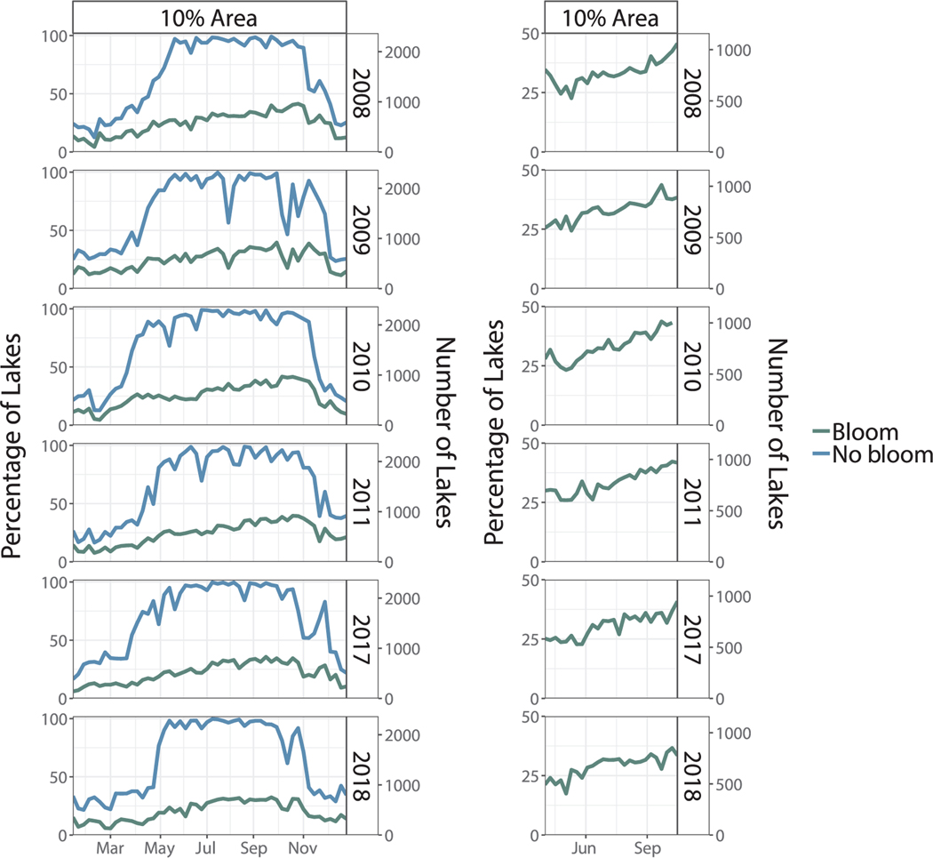
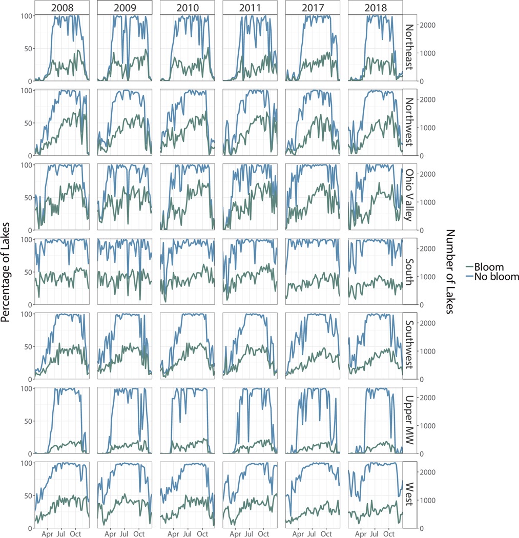
Cyanobacterial harmful algal blooms are the most common form of harmful algal blooms in freshwater systems throughout the world. However, sampling of cyanobacteria in inland lakes is limited both spatially and temporally. Satellite data has proven to be an effective tool to monitor cyanobacteria in freshwater lakes across the United States. This study uses data from the European Space Agency Envisat MEdium Resolution Imaging Spectrometer and the Sentinel-3 Ocean and Land Color Instrument to provide a national overview of the percentage of lakes experiencing a cyanobacterial bloom on a weekly basis for 2008-2011, 2017, and 2018. A total of 2321 lakes across the contiguous United States were included in the analysis. We examined four different thresholds to define when a waterbody is classified as experiencing a bloom. Across these four thresholds, we explored variability in bloom percentage with changes in seasonality and lake size. As a validation of algorithm performance, we analyzed the agreement between satellite observations and previously established ecological patterns, although data availability in the wintertime limited these comparisons on a year-round basis. Changes in cyanobacterial bloom percentage at the national scale followed the well-known temporal pattern of freshwater blooms. The percentage of lakes experiencing a bloom increased throughout the year, reached a maximum in fall, and decreased through the winter. Wintertime data, particularly in northern regions, were consistently limited due to snow and ice cover. With the exception of the Southeast and South, regional patterns mimicked patterns found at the national scale. The Southeast and South exhibited an unexpected pattern as cyanobacterial bloom percentage reached a maximum in the winter rather than the summer. Lake Jesup in Florida was used as a case study to validate this observed pattern against field observations of chlorophyll a. Results from this research establish a baseline of annual occurrence of cyanobacterial blooms in inland lakes across the United States. In addition, methods presented in this study can be tailored to fit the specific requirements of an individual system or region.
蓝藻有害藻华是全球淡水系统中最常见的有害藻华形式。然而,内陆湖泊中蓝藻的采样在空间和时间上都受到限制。卫星数据已被证明是监测美国淡水湖泊中蓝藻的有效工具。本研究使用来自欧洲航天局的环境卫星中等分辨率成像光谱仪和哨兵 - 3海洋和陆地颜色仪器的数据,以提供2008 - 2011年、2017年和2018年每周经历蓝藻水华的湖泊百分比的全国概况。分析中纳入了美国本土的2321个湖泊。我们研究了四个不同的阈值来定义水体何时被归类为经历水华。在这四个阈值范围内,我们探讨了水华百分比随季节性和湖泊大小变化的变异性。作为算法性能的验证,我们分析了卫星观测与先前建立的生态模式之间的一致性,尽管冬季的数据可用性限制了全年的这些比较。全国范围内蓝藻水华百分比的变化遵循了淡水水华众所周知的时间模式。经历水华的湖泊百分比全年增加,在秋季达到最大值,冬季下降。由于冰雪覆盖,冬季数据,特别是在北部地区,一直很有限。除了东南部和南部,区域模式与全国范围内发现的模式相似。东南部和南部呈现出意想不到的模式,因为蓝藻水华百分比在冬季而非夏季达到最大值。佛罗里达州的杰苏普湖被用作案例研究,以根据叶绿素a的实地观测验证这一观测模式。本研究结果建立了美国内陆湖泊蓝藻水华年发生率的基线。此外,本研究中提出的方法可以进行调整以适应单个系统或区域的特定要求。