Dargin Jennifer S, Li Qingchun, Jawer Gabrielle, Xiao Xin, Mostafavi Ali
Zachry Department of Civil and Environmental Engineering, Texas A&M University, College Station, TX, USA.
Urban Resilience.AI Lab, Texas A&M University, USA.
Int J Disaster Risk Reduct. 2021 Nov;65:102560. doi: 10.1016/j.ijdrr.2021.102560. Epub 2021 Sep 16.
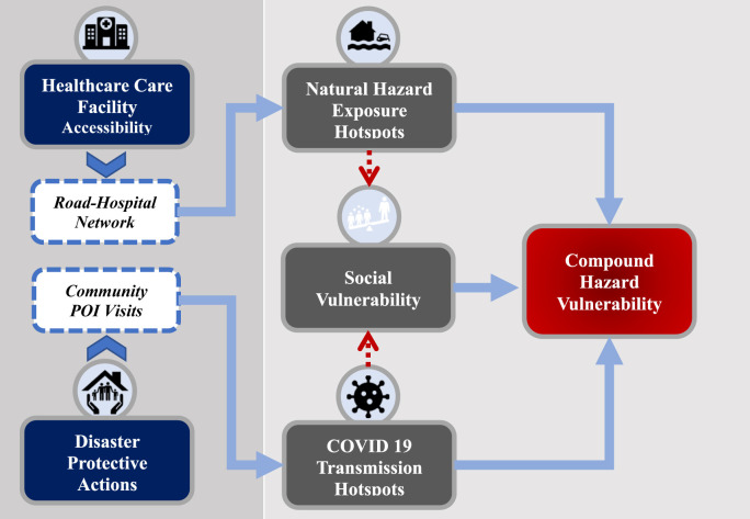
Hurricane season brings new and complex challenges as we continue to battle the COVID-19 pandemic. In May 2020, the National Oceanic and Atmospheric Administration has predicted nearly twice the normal number of tropical storms and hurricanes this season, while projections of COVID-19 models continue to rise in the United States as the Atlantic hurricane season progresses. Our research examines the critical intersection of hurricane response and public health in Harris County, Texas. We examine a hypothetical case of the 2017 Hurricane Harvey occurring amid the current pandemic. This research uses point of interest visitations as location intelligence data provided by SafeGraph together with Social Vulnerability Index and historical flood data to examine the critical intersection of natural hazard planning and response and the COVID-19 pandemic to assess the risks of a compound hazard situation. COVID-19 transmission hotspots and businesses in a community due to storm preparation activity were identified. The main drivers of transmission risk arise from overall pandemic exposure and increased interpersonal contact during hurricane preparation. Residents of health-risk areas will need to make logistical arrangements to visit alternative medical facilities for treatments related to either COVID-19 or physical impacts, such as injuries, due to the hurricane risks. Points of interest needed for disaster preparation are more likely to be situated in high-risk areas, therefore making cross-community spread more likely. Moreover, greater susceptibility could arise from social vulnerability (socioeconomic status and demographic factors) and disrupted access to healthcare facilities. Results from this study can be used to identify high-risk areas for COVID-19 transmission for prioritization in planning for temporary healthcare centers and other essential services in low-risk areas. Understanding the interplay between disaster preparation and the restrictive environment laid out by the pandemic is critical for community leaders and public health officials for ensuring the population has sufficient access to essential infrastructure services. The findings from this study can help guide the direction of disaster planning and pandemic response strategies and policies.
在我们继续抗击新冠疫情之际,飓风季节带来了新的复杂挑战。2020年5月,美国国家海洋和大气管理局预测,本赛季热带风暴和飓风的数量将接近正常数量的两倍,而随着大西洋飓风季节的推进,美国新冠疫情模型的预测数字持续上升。我们的研究考察了德克萨斯州哈里斯县飓风应对与公共卫生的关键交叉点。我们研究了一个假设案例,即2017年的哈维飓风在当前疫情期间发生的情况。这项研究使用兴趣点访问量作为SafeGraph提供的位置情报数据,结合社会脆弱性指数和历史洪水数据,来研究自然灾害规划与应对和新冠疫情的关键交叉点,以评估复合灾害情况的风险。确定了社区中因风暴准备活动而形成的新冠病毒传播热点和企业。传播风险的主要驱动因素来自于整体疫情暴露以及飓风准备期间人际接触的增加。由于存在飓风风险,健康风险地区的居民将需要做出后勤安排,前往其他医疗设施接受与新冠疫情或身体损伤(如受伤)相关的治疗。灾难准备所需的兴趣点更有可能位于高风险地区,因此更有可能导致跨社区传播。此外,社会脆弱性(社会经济地位和人口因素)以及医疗设施获取受阻可能会导致更高的易感性。这项研究的结果可用于确定新冠病毒传播的高风险地区,以便在规划低风险地区的临时医疗中心和其他基本服务时进行优先考虑。了解灾难准备与疫情所带来的限制环境之间的相互作用,对于社区领袖和公共卫生官员确保民众能够充分获得基本基础设施服务至关重要。这项研究的结果有助于指导灾难规划和疫情应对战略及政策的方向。