• 文献检索
  • 文档翻译
  • 深度研究
  • 学术资讯
  • Suppr Zotero 插件Zotero 插件
  • 邀请有礼
  • 套餐&价格
  • 历史记录
应用&插件
Suppr Zotero 插件Zotero 插件浏览器插件Mac 客户端Windows 客户端微信小程序
定价
高级版会员购买积分包购买API积分包
服务
文献检索文档翻译深度研究API 文档MCP 服务
关于我们
关于 Suppr公司介绍联系我们用户协议隐私条款
关注我们

Suppr 超能文献

核心技术专利:CN118964589B侵权必究
粤ICP备2023148730 号-1Suppr @ 2026

文献检索

告别复杂PubMed语法,用中文像聊天一样搜索,搜遍4000万医学文献。AI智能推荐,让科研检索更轻松。

立即免费搜索

文件翻译

保留排版,准确专业,支持PDF/Word/PPT等文件格式,支持 12+语言互译。

免费翻译文档

深度研究

AI帮你快速写综述,25分钟生成高质量综述,智能提取关键信息,辅助科研写作。

立即免费体验

基于视觉 SLAM 的行星构建机器人建图方法。

Visual SLAM-Based Robotic Mapping Method for Planetary Construction.

机构信息

Department of Geoinformatic Engineering, Inha University, Incheon 22212, Korea.

Department of Mechanical Engineering, College of Engineering, Korea Advanced Institute of Science and Technology, Daejeon 34141, Korea.

出版信息

Sensors (Basel). 2021 Nov 19;21(22):7715. doi: 10.3390/s21227715.

DOI:10.3390/s21227715
PMID:34833786
原文链接:https://pmc.ncbi.nlm.nih.gov/articles/PMC8621460/
Abstract

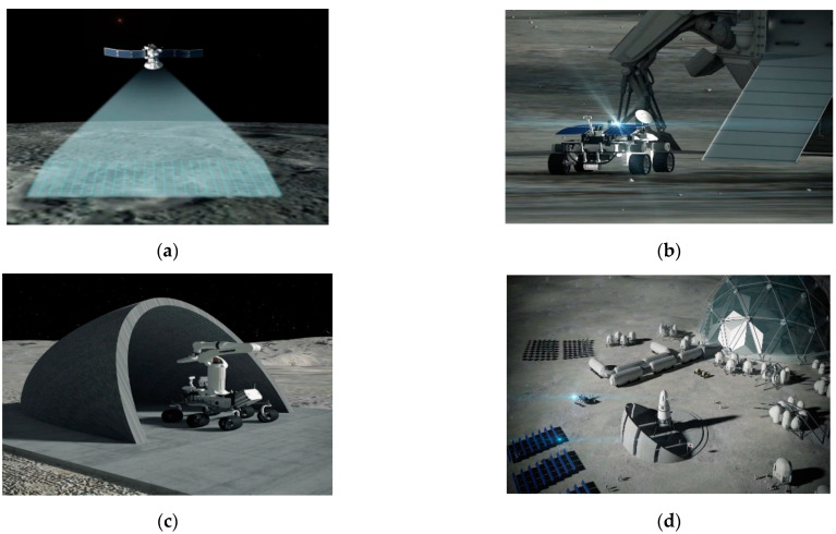
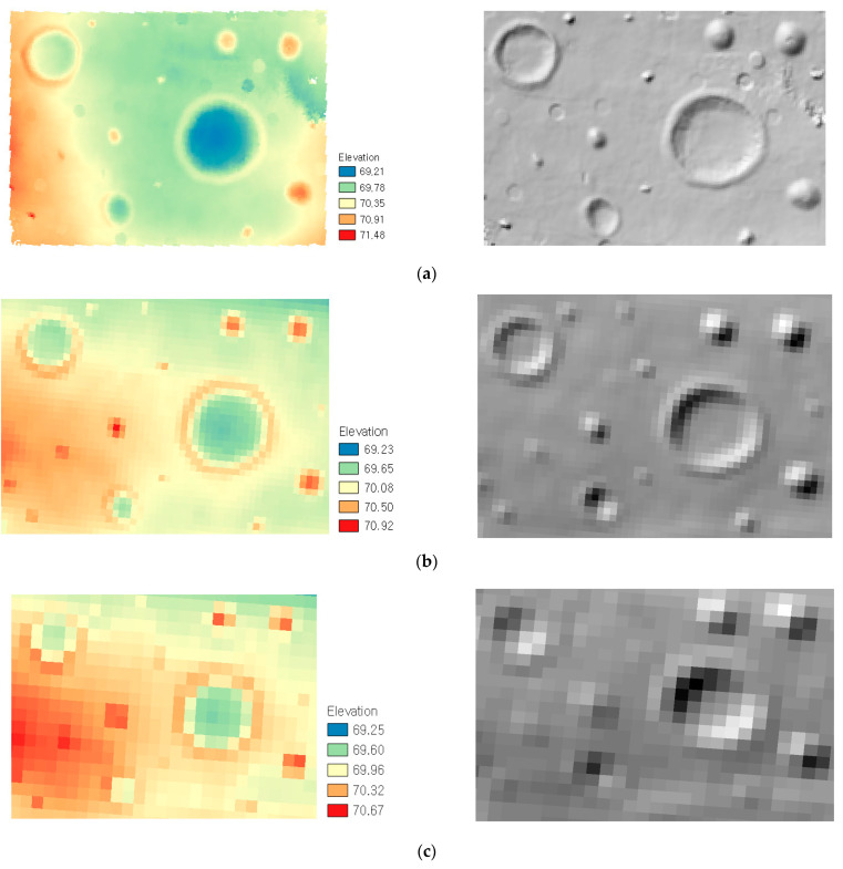
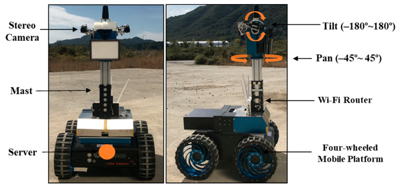
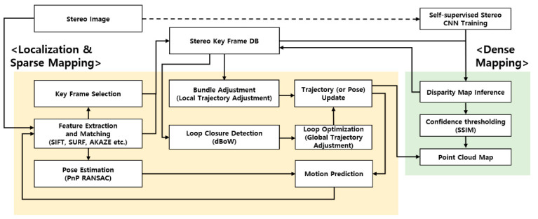
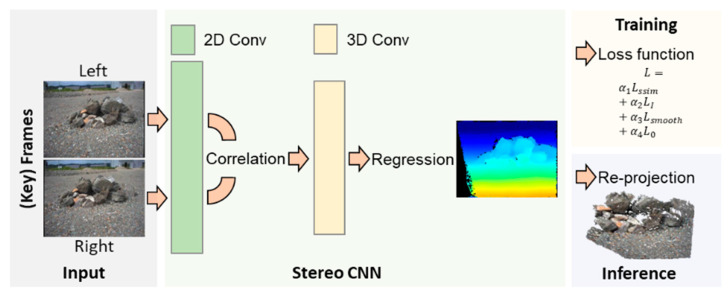
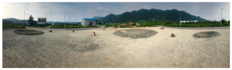
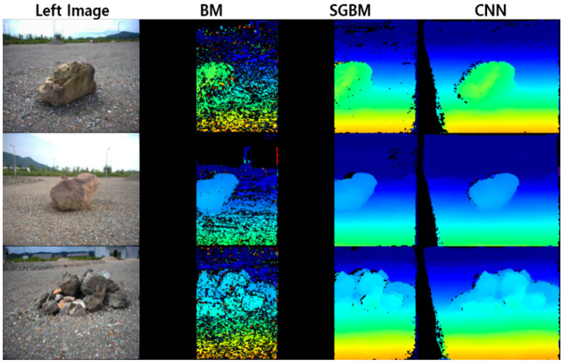
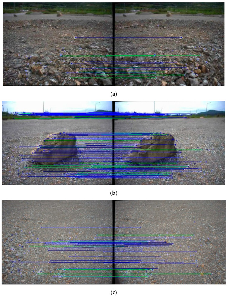
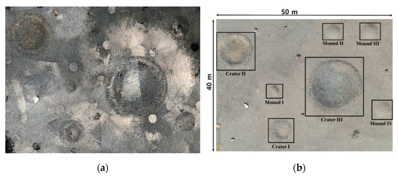
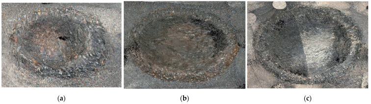
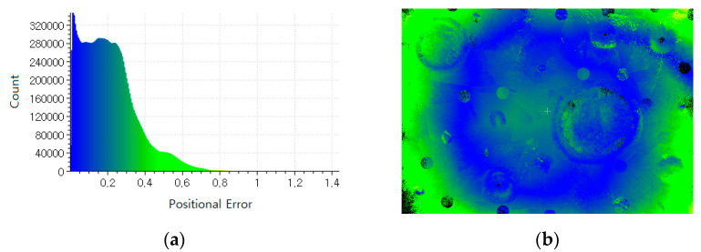
With the recent discovery of water-ice and lava tubes on the Moon and Mars along with the development of in-situ resource utilization (ISRU) technology, the recent planetary exploration has focused on rover (or lander)-based surface missions toward the base construction for long-term human exploration and habitation. However, a 3D terrain map, mostly based on orbiters' terrain images, has insufficient resolutions for construction purposes. In this regard, this paper introduces the visual simultaneous localization and mapping (SLAM)-based robotic mapping method employing a stereo camera system on a rover. In the method, S-PTAM is utilized as a base framework, with which the disparity map from the self-supervised deep learning is combined to enhance the mapping capabilities under homogeneous and unstructured environments of planetary terrains. The overall performance of the proposed method was evaluated in the emulated planetary terrain and validated with potential results.

摘要

随着最近在月球和火星上发现水冰和熔岩管,以及原位资源利用 (ISRU) 技术的发展,最近的行星探测重点是基于漫游者(或着陆器)的表面任务,朝着长期人类探索和居住的基地建设方向发展。然而,主要基于轨道飞行器地形图像的三维地形地图对于建筑目的来说分辨率不足。在这方面,本文介绍了一种基于视觉同时定位与制图 (SLAM) 的机器人制图方法,该方法在漫游者上使用立体相机系统。在该方法中,S-PTAM 被用作基础框架,通过该框架结合来自自监督深度学习的视差图,可以增强行星地形的同质和非结构化环境下的制图能力。在所提出的方法的整体性能在模拟行星地形中进行了评估,并验证了潜在的结果。

https://cdn.ncbi.nlm.nih.gov/pmc/blobs/0523/8621460/b868a3a137b6/sensors-21-07715-g011.jpg
https://cdn.ncbi.nlm.nih.gov/pmc/blobs/0523/8621460/4197b2b8e84b/sensors-21-07715-g001.jpg
https://cdn.ncbi.nlm.nih.gov/pmc/blobs/0523/8621460/b1c07513a585/sensors-21-07715-g002.jpg
https://cdn.ncbi.nlm.nih.gov/pmc/blobs/0523/8621460/e1dbe0830497/sensors-21-07715-g003.jpg
https://cdn.ncbi.nlm.nih.gov/pmc/blobs/0523/8621460/767379c7e345/sensors-21-07715-g004.jpg
https://cdn.ncbi.nlm.nih.gov/pmc/blobs/0523/8621460/49d03034bd0b/sensors-21-07715-g005.jpg
https://cdn.ncbi.nlm.nih.gov/pmc/blobs/0523/8621460/4c091d7ba57a/sensors-21-07715-g006.jpg
https://cdn.ncbi.nlm.nih.gov/pmc/blobs/0523/8621460/f0e6aa3e73cb/sensors-21-07715-g007.jpg
https://cdn.ncbi.nlm.nih.gov/pmc/blobs/0523/8621460/63edd6670b88/sensors-21-07715-g008.jpg
https://cdn.ncbi.nlm.nih.gov/pmc/blobs/0523/8621460/ff0ab908fc24/sensors-21-07715-g009a.jpg
https://cdn.ncbi.nlm.nih.gov/pmc/blobs/0523/8621460/91d03777a6d3/sensors-21-07715-g010.jpg
https://cdn.ncbi.nlm.nih.gov/pmc/blobs/0523/8621460/b868a3a137b6/sensors-21-07715-g011.jpg

相似文献

1
Visual SLAM-Based Robotic Mapping Method for Planetary Construction.基于视觉 SLAM 的行星构建机器人建图方法。
Sensors (Basel). 2021 Nov 19;21(22):7715. doi: 10.3390/s21227715.
2
The Mars 2020 Engineering Cameras and Microphone on the Perseverance Rover: A Next-Generation Imaging System for Mars Exploration.“毅力号”火星探测器上的火星2020工程相机和麦克风:用于火星探测的下一代成像系统。
Space Sci Rev. 2020;216(8):137. doi: 10.1007/s11214-020-00765-9. Epub 2020 Nov 24.
3
Scientific exploration of challenging planetary analog environments with a team of legged robots.利用一队腿足机器人探索具有挑战性的行星模拟环境的科学研究。
Sci Robot. 2023 Jul 12;8(80):eade9548. doi: 10.1126/scirobotics.ade9548.
4
Strategies for Deploying a Sensor Network to Explore Planetary Lava Tubes.部署传感器网络以探索行星熔岩管的策略。
Sensors (Basel). 2021 Sep 16;21(18):6203. doi: 10.3390/s21186203.
5
A Hansel & Gretel breadcrumb-style dynamically deployed communication network paradigm using mesh topology for planetary subsurface exploration.一种采用网状拓扑结构、类似汉塞尔与格蕾特面包屑风格的动态部署通信网络范式,用于行星地下探测。
Adv Space Res. 2023 Jul 15;72(2):518-528. doi: 10.1016/j.asr.2023.02.012. Epub 2023 Feb 11.
6
Investigating Habitability with an Integrated Rock-Climbing Robot and Astrobiology Instrument Suite.利用集成攀岩机器人和天体生物学仪器套件研究可居住性。
Astrobiology. 2020 Dec;20(12):1427-1449. doi: 10.1089/ast.2019.2177. Epub 2020 Oct 14.
7
An Improved Deep Residual Network-Based Semantic Simultaneous Localization and Mapping Method for Monocular Vision Robot.基于改进深度残差网络的单目视觉机器人语义同时定位与建图方法。
Comput Intell Neurosci. 2020 Feb 10;2020:7490840. doi: 10.1155/2020/7490840. eCollection 2020.
8
Towards Camera-LIDAR Fusion-Based Terrain Modelling for Planetary Surfaces: Review and Analysis.面向基于相机-激光雷达融合的行星表面地形建模:综述与分析
Sensors (Basel). 2016 Nov 20;16(11):1952. doi: 10.3390/s16111952.
9
BASEPROD: The Bardenas Semi-Desert Planetary Rover Dataset.BASEPROD:巴尔德纳斯半沙漠行星漫游者数据集。
Sci Data. 2024 Sep 27;11(1):1054. doi: 10.1038/s41597-024-03881-1.
10
Deep Multi-Layer Perception Based Terrain Classification for Planetary Exploration Rovers.基于深度多层感知器的行星探测漫游车地形分类
Sensors (Basel). 2019 Jul 13;19(14):3102. doi: 10.3390/s19143102.

引用本文的文献

1
Uncertainty-Aware Depth Network for Visual Inertial Odometry of Mobile Robots.用于移动机器人视觉惯性里程计的不确定性感知深度网络
Sensors (Basel). 2024 Oct 16;24(20):6665. doi: 10.3390/s24206665.
2
A review of visual SLAM for robotics: evolution, properties, and future applications.机器人视觉同步定位与地图构建综述:演进、特性及未来应用
Front Robot AI. 2024 Apr 10;11:1347985. doi: 10.3389/frobt.2024.1347985. eCollection 2024.
3
A Review on Visual-SLAM: Advancements from Geometric Modelling to Learning-Based Semantic Scene Understanding Using Multi-Modal Sensor Fusion.

本文引用的文献

1
The Mars 2020 Engineering Cameras and Microphone on the Perseverance Rover: A Next-Generation Imaging System for Mars Exploration.“毅力号”火星探测器上的火星2020工程相机和麦克风:用于火星探测的下一代成像系统。
Space Sci Rev. 2020;216(8):137. doi: 10.1007/s11214-020-00765-9. Epub 2020 Nov 24.
2
Robotic System for Inspection by Contact of Bridge Beams Using UAVs.基于无人机的桥梁梁体接触式巡检机器人系统。
Sensors (Basel). 2019 Jan 14;19(2):305. doi: 10.3390/s19020305.
3
Towards Camera-LIDAR Fusion-Based Terrain Modelling for Planetary Surfaces: Review and Analysis.
基于多模态传感器融合的视觉 SLAM 综述:从几何建模到基于学习的语义场景理解的进展。
Sensors (Basel). 2022 Sep 25;22(19):7265. doi: 10.3390/s22197265.
4
Mobile Robot Localization and Mapping Algorithm Based on the Fusion of Image and Laser Point Cloud.基于图像与激光点云融合的移动机器人定位与地图构建算法
Sensors (Basel). 2022 May 28;22(11):4114. doi: 10.3390/s22114114.
面向基于相机-激光雷达融合的行星表面地形建模:综述与分析
Sensors (Basel). 2016 Nov 20;16(11):1952. doi: 10.3390/s16111952.
4
RGB-D SLAM Based on Extended Bundle Adjustment with 2D and 3D Information.基于具有二维和三维信息的扩展光束平差的RGB-D同步定位与地图构建
Sensors (Basel). 2016 Aug 13;16(8):1285. doi: 10.3390/s16081285.
5
Water extraction on Mars for an expanding human colony.在火星上进行水提取,以支持不断扩张的人类殖民地。
Life Sci Space Res (Amst). 2015 Nov;7:57-60. doi: 10.1016/j.lssr.2015.10.001. Epub 2015 Oct 22.
6
A young multilayered terrane of the northern Mare Imbrium revealed by Chang'E-3 mission.嫦娥三号任务揭示的北月海年轻多层地貌。
Science. 2015 Mar 13;347(6227):1226-9. doi: 10.1126/science.1259866.
7
Hydrogen mapping of the lunar south pole using the LRO neutron detector experiment LEND.利用月球轨道飞行器中子探测器实验 LEND 对月球南极进行氢测绘。
Science. 2010 Oct 22;330(6003):483-6. doi: 10.1126/science.1185696.
8
Stereo processing by semiglobal matching and mutual information.通过半全局匹配和互信息进行立体处理。
IEEE Trans Pattern Anal Mach Intell. 2008 Feb;30(2):328-41. doi: 10.1109/TPAMI.2007.1166.