• 文献检索
  • 文档翻译
  • 深度研究
  • 学术资讯
  • Suppr Zotero 插件Zotero 插件
  • 邀请有礼
  • 套餐&价格
  • 历史记录
应用&插件
Suppr Zotero 插件Zotero 插件浏览器插件Mac 客户端Windows 客户端微信小程序
定价
高级版会员购买积分包购买API积分包
服务
文献检索文档翻译深度研究API 文档MCP 服务
关于我们
关于 Suppr公司介绍联系我们用户协议隐私条款
关注我们

Suppr 超能文献

核心技术专利:CN118964589B侵权必究
粤ICP备2023148730 号-1Suppr @ 2026

文献检索

告别复杂PubMed语法,用中文像聊天一样搜索,搜遍4000万医学文献。AI智能推荐,让科研检索更轻松。

立即免费搜索

文件翻译

保留排版,准确专业,支持PDF/Word/PPT等文件格式,支持 12+语言互译。

免费翻译文档

深度研究

AI帮你快速写综述,25分钟生成高质量综述,智能提取关键信息,辅助科研写作。

立即免费体验

北印度旁遮普地区城市化景观的空间格局呈现出分形理论所预测的特征。

Spatial patterns of urbanising landscapes in the North Indian Punjab show features predicted by fractal theory.

机构信息

Organic Plant Production and Agroecosystems Research in the Tropics and Subtropics (OPATS), University of Kassel, Steinstr. 19, 37123, Witzenhausen, Germany.

出版信息

Sci Rep. 2022 Feb 2;12(1):1819. doi: 10.1038/s41598-022-05906-4.

DOI:10.1038/s41598-022-05906-4
PMID:35110667
原文链接:https://pmc.ncbi.nlm.nih.gov/articles/PMC8810886/
Abstract

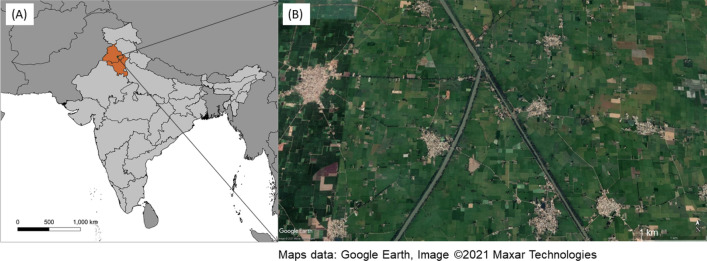
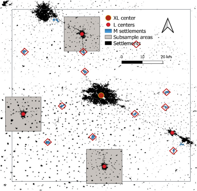
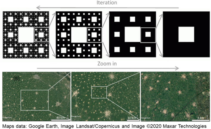
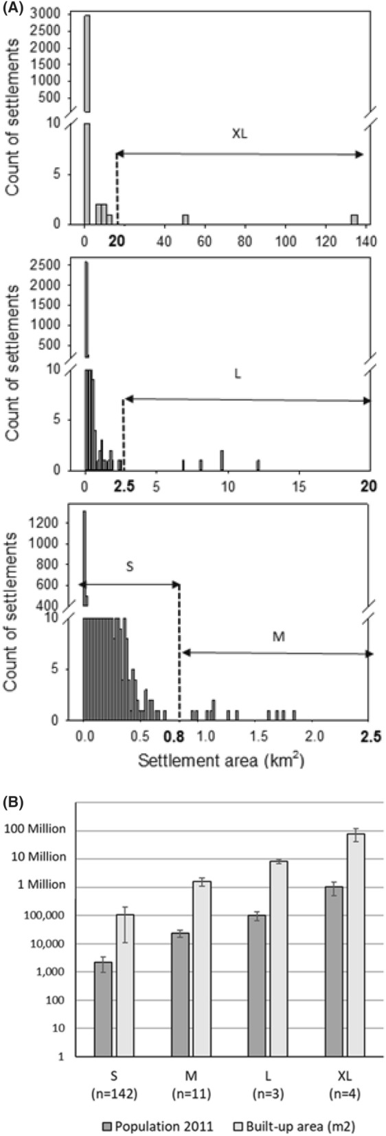
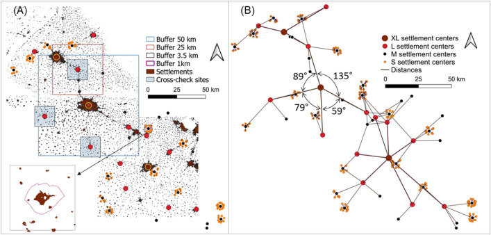
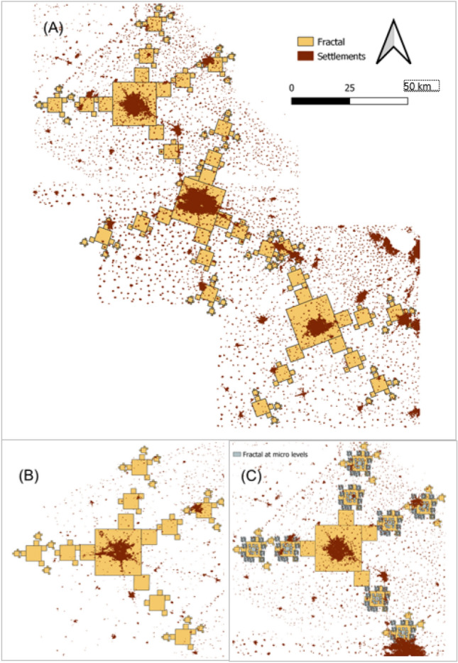
Understanding and governing human settlement patterns is a major challenge of the urban age. While rural settlements emerge as parts of agricultural landscapes, cities typically evolve in economically strategic locations, and over time form hierarchical systems of cities. Purposeful planning and the collective, self-organized behavior of the inhabitants interact in the development of regional settlement patterns. Since self-organizing systems often produce fractal patterns in nature, this study combines approaches of land use science, city ranking, and urban planning under a fractal theory framework, to analyze the settlement system of the Indian Punjab. Scaling levels were defined by discontinuities in the size distribution of built-up areas (Global Urban Footprint), which correlated to population-based classifications (r = 0.9591). Self-similarity across scales was supported by geo-statistical similarity (p < 0.05) of distances and angles between settlements of successive classes, and the overall fractal dimension of D = 1.95. When compared to a modeled Sierpinski Carpet, more than 50% of the settlements met the fractal geometry rules at larger scales. The spatial distribution of small villages, however, deviated, indicating a scale-related shift in organizing principles. Explicitly acknowledging cross-scale relations and self-organisation in regional planning policies may lead to more sustainable settlement structures that are in harmony with natural system properties.

摘要

理解和治理人类住区模式是城市时代的主要挑战。虽然农村住区是农业景观的一部分,但城市通常在经济战略位置上发展,并随着时间的推移形成城市的等级制度。有目的的规划和居民的集体自组织行为在区域住区模式的发展中相互作用。由于自组织系统在自然界中经常产生分形模式,因此本研究在分形理论框架下结合土地利用科学、城市排名和城市规划的方法,来分析印度旁遮普邦的住区系统。通过对建成区(全球城市足迹)的大小分布的不连续性来定义尺度等级,这些不连续性与基于人口的分类相关(r=0.9591)。通过对连续级别之间的距离和角度的地统计学相似性(p<0.05)以及整体分形维数 D=1.95,支持了跨尺度的自相似性。与模拟的谢尔宾斯基地毯相比,超过 50%的住区在较大的尺度上符合分形几何规则。然而,小村庄的空间分布却有所偏离,这表明在组织原则上存在与尺度相关的转变。在区域规划政策中明确承认跨尺度关系和自组织,可能会导致更可持续的住区结构,使其与自然系统属性相协调。

https://cdn.ncbi.nlm.nih.gov/pmc/blobs/9dd4/8810886/cdf08004bafe/41598_2022_5906_Fig8_HTML.jpg
https://cdn.ncbi.nlm.nih.gov/pmc/blobs/9dd4/8810886/2837924b8e23/41598_2022_5906_Fig1_HTML.jpg
https://cdn.ncbi.nlm.nih.gov/pmc/blobs/9dd4/8810886/7a73ee5c17ba/41598_2022_5906_Fig2_HTML.jpg
https://cdn.ncbi.nlm.nih.gov/pmc/blobs/9dd4/8810886/a4aabd5a3d59/41598_2022_5906_Fig3_HTML.jpg
https://cdn.ncbi.nlm.nih.gov/pmc/blobs/9dd4/8810886/6ab2545ee732/41598_2022_5906_Fig4_HTML.jpg
https://cdn.ncbi.nlm.nih.gov/pmc/blobs/9dd4/8810886/df4c0d21309f/41598_2022_5906_Fig5_HTML.jpg
https://cdn.ncbi.nlm.nih.gov/pmc/blobs/9dd4/8810886/6144d1095dbd/41598_2022_5906_Fig6_HTML.jpg
https://cdn.ncbi.nlm.nih.gov/pmc/blobs/9dd4/8810886/92a76f6846e4/41598_2022_5906_Fig7_HTML.jpg
https://cdn.ncbi.nlm.nih.gov/pmc/blobs/9dd4/8810886/cdf08004bafe/41598_2022_5906_Fig8_HTML.jpg

相似文献

1
Spatial patterns of urbanising landscapes in the North Indian Punjab show features predicted by fractal theory.北印度旁遮普地区城市化景观的空间格局呈现出分形理论所预测的特征。
Sci Rep. 2022 Feb 2;12(1):1819. doi: 10.1038/s41598-022-05906-4.
2
Fractal Modeling and Fractal Dimension Description of Urban Morphology.城市形态的分形建模与分形维数描述
Entropy (Basel). 2020 Aug 30;22(9):961. doi: 10.3390/e22090961.
3
Spatial behavior analysis at the global level using fractal geometry.
Nonlinear Dynamics Psychol Life Sci. 2008 Jan;12(1):3-13.
4
Emergent self-similarity and scaling properties of fractal intra-urban heat islets for diverse global cities.多样全球城市中,城市热岛分形内部的紧急自相似性和标度属性。
Phys Rev E. 2019 Sep;100(3-1):032142. doi: 10.1103/PhysRevE.100.032142.
5
Spatial Measures of Urban Systems: from Entropy to Fractal Dimension.城市系统的空间测度:从熵到分形维数
Entropy (Basel). 2018 Dec 19;20(12):991. doi: 10.3390/e20120991.
6
Tools for mapping multi-scale settlement patterns of building footprints: An introduction to the R package foot.用于绘制建筑足迹多尺度分布格局的工具:R 包 foot 简介
PLoS One. 2021 Feb 25;16(2):e0247535. doi: 10.1371/journal.pone.0247535. eCollection 2021.
7
Natural spatial pattern-When mutual socio-geo distances between cities follow Benford's law.自然空间模式——当城市之间的社会-地理距离相互遵循本福德定律时。
PLoS One. 2022 Oct 20;17(10):e0276450. doi: 10.1371/journal.pone.0276450. eCollection 2022.
8
[Simulation and prediction of urban and rural settlement growth and land use change in Yingkou City].[营口市城乡聚落增长与土地利用变化的模拟与预测]
Ying Yong Sheng Tai Xue Bao. 2008 Jul;19(7):1529-36.
9
Preliminary evidence for a theory of the fractal city.分形城市理论的初步证据。
Environ Plan A. 1996 Oct;28(10):1,745-62.
10
How the geometry of cities determines urban scaling laws.城市的几何形状如何决定城市规模法则。
J R Soc Interface. 2021 Mar;18(176):20200705. doi: 10.1098/rsif.2020.0705. Epub 2021 Mar 17.

引用本文的文献

1
Towards large-scale analyses of settlement patterns in urbanizing landscapes-findings of first studies for India, Egypt, and China.迈向城市化景观中聚落模式的大规模分析——印度、埃及和中国的首批研究成果
Sci Rep. 2024 Oct 28;14(1):25782. doi: 10.1038/s41598-024-74678-w.
2
Fractal dimension complexity of gravitation fractals in central place theory.中心地理论中引力分形的分形维数复杂性。
Sci Rep. 2023 Feb 9;13(1):2343. doi: 10.1038/s41598-023-28534-y.

本文引用的文献

1
Global mapping of urban-rural catchment areas reveals unequal access to services.全球城乡流域区域制图揭示了服务获取的不平等。
Proc Natl Acad Sci U S A. 2021 Jan 12;118(2). doi: 10.1073/pnas.2011990118.
2
Multifractality and Network Analysis of Phase Transition.相变的多重分形与网络分析
PLoS One. 2017 Jan 20;12(1):e0170467. doi: 10.1371/journal.pone.0170467. eCollection 2017.
3
The use of fractal dimension and lacunarity in the characterization of mast cell degranulation in rainbow trout (Onchorhynchus mykiss).分形维数和空隙率在虹鳟(Onchorhynchus mykiss)肥大细胞脱颗粒特征描述中的应用
J Microsc. 2014 Nov;256(2):82-9. doi: 10.1111/jmi.12160. Epub 2014 Aug 4.
4
NIH Image to ImageJ: 25 years of image analysis.NIH 图像到 ImageJ:25 年的图像分析。
Nat Methods. 2012 Jul;9(7):671-5. doi: 10.1038/nmeth.2089.
5
The size, scale, and shape of cities.城市的规模、尺度和形状。
Science. 2008 Feb 8;319(5864):769-71. doi: 10.1126/science.1151419.
6
Time, structure, and fluctuations.时间、结构和涨落。
Science. 1978 Sep 1;201(4358):777-85. doi: 10.1126/science.201.4358.777.
7
Fractal methods and results in cellular morphology--dimensions, lacunarity and multifractals.分形方法与细胞形态学结果——维度、孔隙率和多重分形
J Neurosci Methods. 1996 Nov;69(2):123-36. doi: 10.1016/S0165-0270(96)00080-5.