• 文献检索
  • 文档翻译
  • 深度研究
  • 学术资讯
  • Suppr Zotero 插件Zotero 插件
  • 邀请有礼
  • 套餐&价格
  • 历史记录
应用&插件
Suppr Zotero 插件Zotero 插件浏览器插件Mac 客户端Windows 客户端微信小程序
定价
高级版会员购买积分包购买API积分包
服务
文献检索文档翻译深度研究API 文档MCP 服务
关于我们
关于 Suppr公司介绍联系我们用户协议隐私条款
关注我们

Suppr 超能文献

核心技术专利:CN118964589B侵权必究
粤ICP备2023148730 号-1Suppr @ 2026

文献检索

告别复杂PubMed语法,用中文像聊天一样搜索,搜遍4000万医学文献。AI智能推荐,让科研检索更轻松。

立即免费搜索

文件翻译

保留排版,准确专业,支持PDF/Word/PPT等文件格式,支持 12+语言互译。

免费翻译文档

深度研究

AI帮你快速写综述,25分钟生成高质量综述,智能提取关键信息,辅助科研写作。

立即免费体验

欧洲中期天气预报中心耦合系统中土地覆盖和植被季节性的升级:基于通量网站点、METEOSAT卫星陆地表面温度和ERA5大气再分析的验证

Upgrading Land-Cover and Vegetation Seasonality in the ECMWF Coupled System: Verification With FLUXNET Sites, METEOSAT Satellite Land Surface Temperatures, and ERA5 Atmospheric Reanalysis.

作者信息

Nogueira Miguel, Boussetta Souhail, Balsamo Gianpaolo, Albergel Clément, Trigo Isabel F, Johannsen Frederico, Miralles Diego G, Dutra Emanuel

机构信息

Instituto Dom Luiz, IDL Faculty of Sciences University of Lisbon Lisbon Portugal.

ECMWF Reading UK.

出版信息

J Geophys Res Atmos. 2021 Aug 16;126(15):e2020JD034163. doi: 10.1029/2020JD034163. Epub 2021 Aug 2.

DOI:10.1029/2020JD034163
PMID:35866004
原文链接:https://pmc.ncbi.nlm.nih.gov/articles/PMC9286567/
Abstract

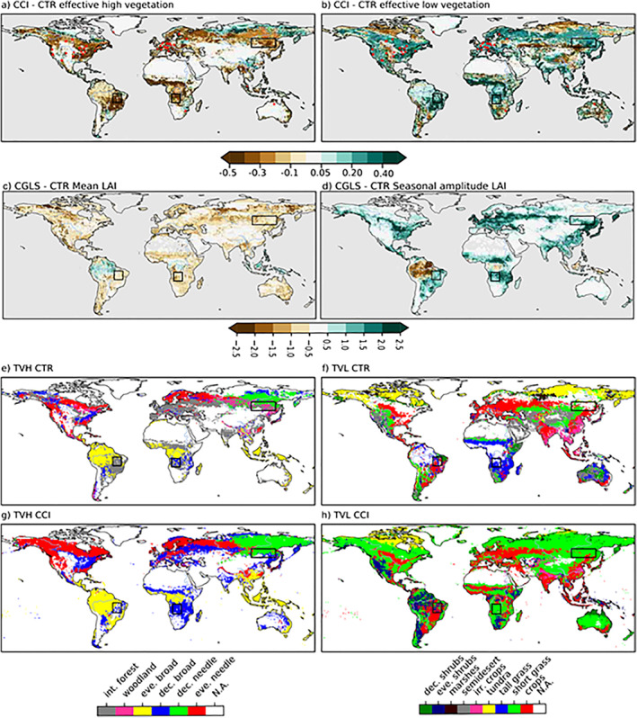
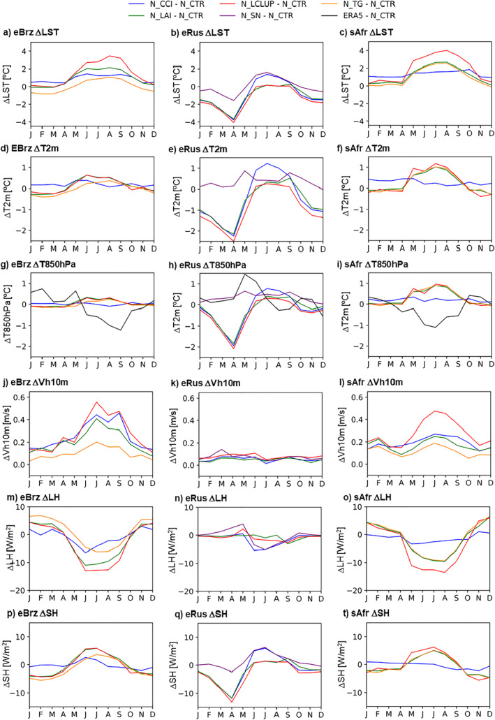
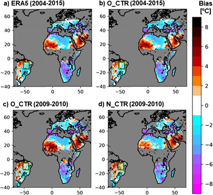
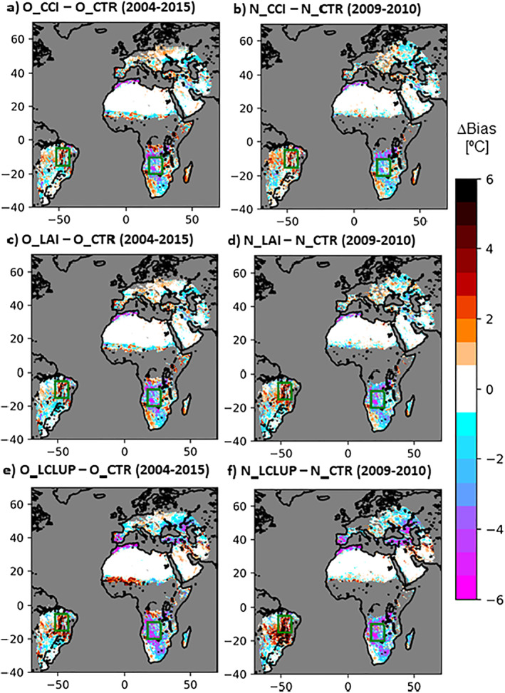
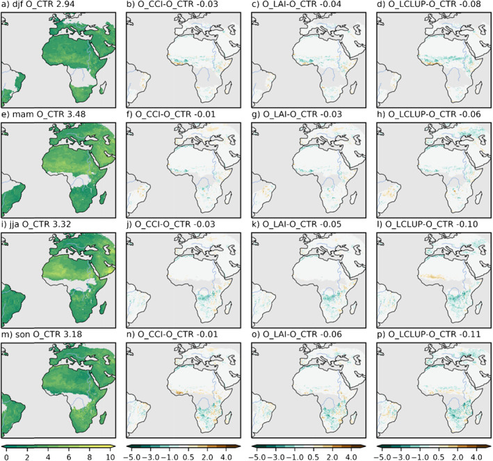
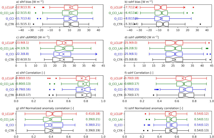
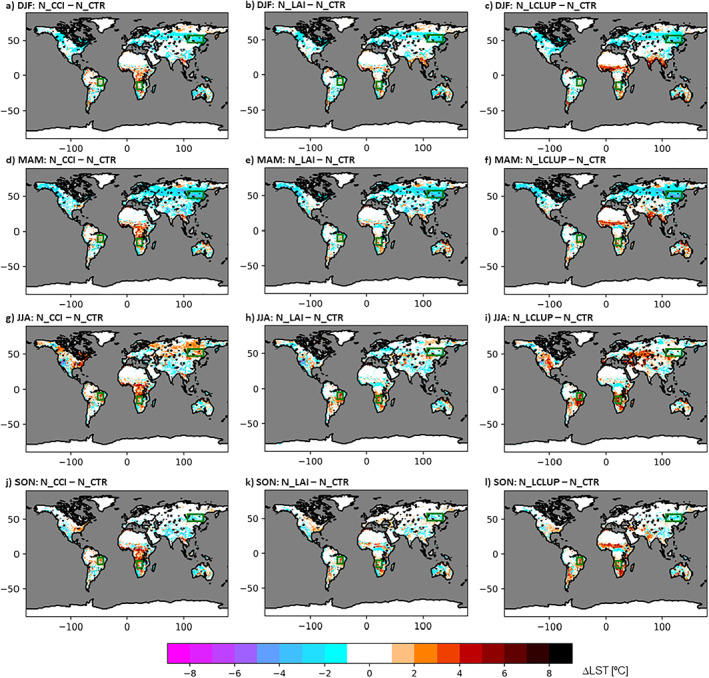
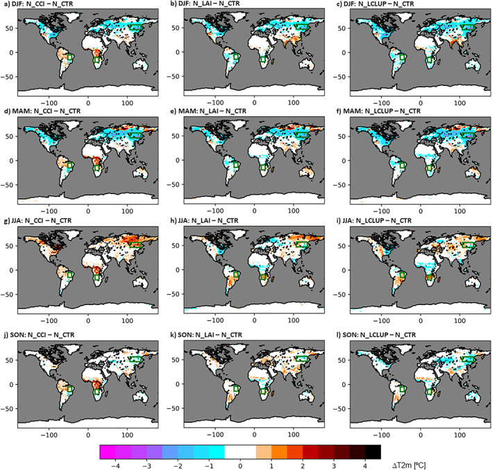
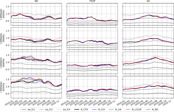
In this study, we show that limitations in the representation of land cover and vegetation seasonality in the European Centre for Medium-Range Weather Forecasting (ECMWF) model are partially responsible for large biases (up to ∼10°C, either positive or negative depending on the region) on the simulated daily maximum land surface temperature (LST) with respect to satellite Earth Observations (EOs) products from the Land Surface Analysis Satellite Application Facility. The error patterns were coherent in offline land-surface and coupled land-atmosphere simulations, and in ECMWF's latest generation reanalysis (ERA5). Subsequently, we updated the ECMWF model's land cover characterization leveraging on state-of-the-art EOs-the European Space Agency Climate Change Initiative land cover data set and the Copernicus Global Land Services leaf area index. Additionally, we tested a clumping parameterization, introducing seasonality to the effective low vegetation coverage. The updates reduced the overall daily maximum LST bias and unbiased root-mean-squared errors. In contrast, the implemented updates had a neutral impact on daily minimum LST. Our results also highlighted the complex regional heterogeneities in the atmospheric sensitivity to land cover and vegetation changes, particularly with issues emerging over eastern Brazil and northeastern Asia. These issues called for a re-calibration of model parameters (e.g., minimum stomatal resistance, roughness length, rooting depth), along with a revision of several model assumptions (e.g., snow shading by high vegetation).

摘要

在本研究中,我们表明,欧洲中期天气预报中心(ECMWF)模型中陆地覆盖和植被季节性表征的局限性,是造成模拟的每日陆地表面最高温度(LST)相对于陆地表面分析卫星应用设施的卫星地球观测(EO)产品存在较大偏差(高达约10°C,正负偏差取决于区域)的部分原因。在离线陆地表面和陆气耦合模拟以及ECMWF的最新一代再分析(ERA5)中,误差模式是一致的。随后,我们利用最先进的EO数据——欧洲航天局气候变化倡议陆地覆盖数据集和哥白尼全球陆地服务叶面积指数,更新了ECMWF模型的陆地覆盖特征描述。此外,我们测试了一种聚集参数化方法,将季节性引入到有效的低植被覆盖中。这些更新减少了每日陆地表面最高温度的总体偏差和无偏均方根误差。相比之下,实施的更新对每日陆地表面最低温度有中性影响。我们的结果还突出了大气对陆地覆盖和植被变化敏感性方面复杂的区域异质性,特别是在巴西东部和亚洲东北部出现的问题。这些问题需要重新校准模型参数(例如最小气孔阻力、粗糙度长度、根系深度),同时修订几个模型假设(例如高植被对雪的遮蔽)。

https://cdn.ncbi.nlm.nih.gov/pmc/blobs/9de6/9286567/c969205628d8/JGRD-126-0-g007.jpg
https://cdn.ncbi.nlm.nih.gov/pmc/blobs/9de6/9286567/79454dbc162b/JGRD-126-0-g006.jpg
https://cdn.ncbi.nlm.nih.gov/pmc/blobs/9de6/9286567/186f2ad324e6/JGRD-126-0-g009.jpg
https://cdn.ncbi.nlm.nih.gov/pmc/blobs/9de6/9286567/8bf02829107e/JGRD-126-0-g008.jpg
https://cdn.ncbi.nlm.nih.gov/pmc/blobs/9de6/9286567/66d7764a46dc/JGRD-126-0-g003.jpg
https://cdn.ncbi.nlm.nih.gov/pmc/blobs/9de6/9286567/67beb4908dce/JGRD-126-0-g004.jpg
https://cdn.ncbi.nlm.nih.gov/pmc/blobs/9de6/9286567/3d267a3a19c2/JGRD-126-0-g002.jpg
https://cdn.ncbi.nlm.nih.gov/pmc/blobs/9de6/9286567/6dc6f53a42fa/JGRD-126-0-g001.jpg
https://cdn.ncbi.nlm.nih.gov/pmc/blobs/9de6/9286567/855107636f1c/JGRD-126-0-g005.jpg
https://cdn.ncbi.nlm.nih.gov/pmc/blobs/9de6/9286567/c969205628d8/JGRD-126-0-g007.jpg

相似文献

1
Upgrading Land-Cover and Vegetation Seasonality in the ECMWF Coupled System: Verification With FLUXNET Sites, METEOSAT Satellite Land Surface Temperatures, and ERA5 Atmospheric Reanalysis.欧洲中期天气预报中心耦合系统中土地覆盖和植被季节性的升级:基于通量网站点、METEOSAT卫星陆地表面温度和ERA5大气再分析的验证
J Geophys Res Atmos. 2021 Aug 16;126(15):e2020JD034163. doi: 10.1029/2020JD034163. Epub 2021 Aug 2.
2
Downscaling of ERA5 reanalysis land surface temperature based on attention mechanism and Google Earth Engine.基于注意力机制和谷歌地球引擎的ERA5再分析陆地表面温度降尺度研究
Sci Rep. 2025 Jan 3;15(1):675. doi: 10.1038/s41598-024-83944-w.
3
Evaluation of air temperature estimated by ERA5-Land reanalysis using surface data in Pernambuco, Brazil.利用巴西伯南布哥州地面数据评估 ERA5-Land 再分析估算的气温。
Environ Monit Assess. 2022 Apr 20;194(5):381. doi: 10.1007/s10661-022-10047-2.
4
Analysis and prediction of land surface temperature with increasing urbanisation using satellite imagery.利用卫星图像对城市化进程中地表温度进行分析与预测。
Heliyon. 2024 Nov 14;10(22):e40378. doi: 10.1016/j.heliyon.2024.e40378. eCollection 2024 Nov 30.
5
Effects of climate change on vegetation and snow cover area in Gilgit Baltistan using MODIS data.利用 MODIS 数据研究气候变化对吉尔吉特-巴尔蒂斯坦植被和积雪覆盖面积的影响。
Environ Sci Pollut Res Int. 2023 Feb;30(7):19149-19166. doi: 10.1007/s11356-022-23445-3. Epub 2022 Oct 12.
6
Quantitative assessment of land surface temperature and vegetation indices on a kilometer grid scale.公里网格尺度下地表面温度和植被指数的定量评估。
Environ Sci Pollut Res Int. 2023 Oct;30(49):107236-107258. doi: 10.1007/s11356-023-27418-y. Epub 2023 May 9.
7
Performance of air temperature from ERA5-Land reanalysis in coastal urban agglomeration of Southeast China.ERA5-Land 再分析资料在中国东南部沿海城市群的气温表现。
Sci Total Environ. 2022 Jul 1;828:154459. doi: 10.1016/j.scitotenv.2022.154459. Epub 2022 Mar 9.
8
Snow cover area analysis and its relation with climate variability in Chandra basin, Western Himalaya, during 2001-2017 using MODIS and ERA5 data.利用 MODIS 和 ERA5 数据对 2001-2017 年喜马拉雅山西部昌德拉流域的积雪覆盖面积进行分析及其与气候变化的关系。
Environ Monit Assess. 2020 Jul 7;192(8):489. doi: 10.1007/s10661-020-08442-8.
9
Spatiotemporal variations of land surface albedo and associated influencing factors on the Tibetan Plateau.青藏高原地表反照率的时空变化及其影响因素分析。
Sci Total Environ. 2022 Jan 15;804:150100. doi: 10.1016/j.scitotenv.2021.150100. Epub 2021 Sep 4.
10
Analysis of the relationship among land surface temperature (LST), land use land cover (LULC), and normalized difference vegetation index (NDVI) with topographic elements in the lower Himalayan region.喜马拉雅山脉低海拔地区地表温度(LST)、土地利用土地覆盖(LULC)、归一化植被指数(NDVI)与地形要素之间的关系分析
Heliyon. 2023 Feb 3;9(2):e13322. doi: 10.1016/j.heliyon.2023.e13322. eCollection 2023 Feb.

引用本文的文献

1
Examining the Sensitivity of Satellite-Derived Vegetation Indices to Plant Drought Stress in Grasslands in Poland.研究波兰草原上卫星植被指数对植物干旱胁迫的敏感性。
Plants (Basel). 2024 Aug 20;13(16):2319. doi: 10.3390/plants13162319.

本文引用的文献

1
The FLUXNET2015 dataset and the ONEFlux processing pipeline for eddy covariance data.FLUXNET2015 数据集和涡度相关通量数据的 ONEFlux 处理管道。
Sci Data. 2020 Jul 9;7(1):225. doi: 10.1038/s41597-020-0534-3.
2
Land-atmospheric feedbacks during droughts and heatwaves: state of the science and current challenges.旱涝急转期的陆气反馈:科学现状与当前挑战。
Ann N Y Acad Sci. 2019 Jan;1436(1):19-35. doi: 10.1111/nyas.13912. Epub 2018 Jun 25.
3
Soil Moisture-Temperature Coupling in a Set of Land Surface Models.一组陆面模式中的土壤湿度-温度耦合
J Geophys Res Atmos. 2018 Feb 16;123(3):1481-1498. doi: 10.1002/2017JD027346. Epub 2018 Feb 1.
4
The plumbing of land surface models: is poor performance a result of methodology or data quality?陆面模式的内部机制:性能不佳是方法问题还是数据质量问题?
J Hydrometeorol. 2016 Jun;17(6):1705-1723. doi: 10.1175/JHM-D-15-0171.1. Epub 2016 May 25.
5
Gas valves, forests and global change: a commentary on Jarvis (1976) 'The interpretation of the variations in leaf water potential and stomatal conductance found in canopies in the field'.气阀、森林与全球变化:对贾维斯(1976年)《田间冠层中叶水势和气孔导度变化的解释》的评论
Philos Trans R Soc Lond B Biol Sci. 2015 Apr 19;370(1666). doi: 10.1098/rstb.2014.0311.
6
The energy balance closure problem: an overview.能量平衡闭合问题:综述
Ecol Appl. 2008 Sep;18(6):1351-67. doi: 10.1890/06-0922.1.
7
Forests and climate change: forcings, feedbacks, and the climate benefits of forests.森林与气候变化:作用力、反馈及森林的气候效益
Science. 2008 Jun 13;320(5882):1444-9. doi: 10.1126/science.1155121.
8
Influence of Land-Surface Evapotranspiration on the Earth's Climate.陆面蒸散对地球气候的影响。
Science. 1982 Mar 19;215(4539):1498-501. doi: 10.1126/science.215.4539.1498.
9
Regions of strong coupling between soil moisture and precipitation.土壤湿度与降水之间的强耦合区域。
Science. 2004 Aug 20;305(5687):1138-40. doi: 10.1126/science.1100217.