Berger Katja, Machwitz Miriam, Kycko Marlena, Kefauver Shawn C, Van Wittenberghe Shari, Gerhards Max, Verrelst Jochem, Atzberger Clement, van der Tol Christiaan, Damm Alexander, Rascher Uwe, Herrmann Ittai, Paz Veronica Sobejano, Fahrner Sven, Pieruschka Roland, Prikaziuk Egor, Buchaillot Ma Luisa, Halabuk Andrej, Celesti Marco, Koren Gerbrand, Gormus Esra Tunc, Rossini Micol, Foerster Michael, Siegmann Bastian, Abdelbaki Asmaa, Tagliabue Giulia, Hank Tobias, Darvishzadeh Roshanak, Aasen Helge, Garcia Monica, Pôças Isabel, Bandopadhyay Subhajit, Sulis Mauro, Tomelleri Enrico, Rozenstein Offer, Filchev Lachezar, Stancile Gheorghe, Schlerf Martin
Image Processing Laboratory (IPL), University of Valencia, C/Catedrático José Beltrán 2, Paterna 46980, Valencia, Spain.
Department of Geography, Ludwig-Maximilians-Universität München (LMU), Luisenstr. 37, 80333 Munich, Germany.
Remote Sens Environ. 2022 Aug 4;280:113198. doi: 10.1016/j.rse.2022.113198. eCollection 2022 Oct.
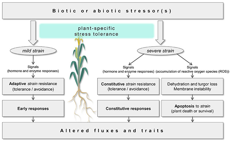
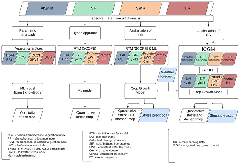
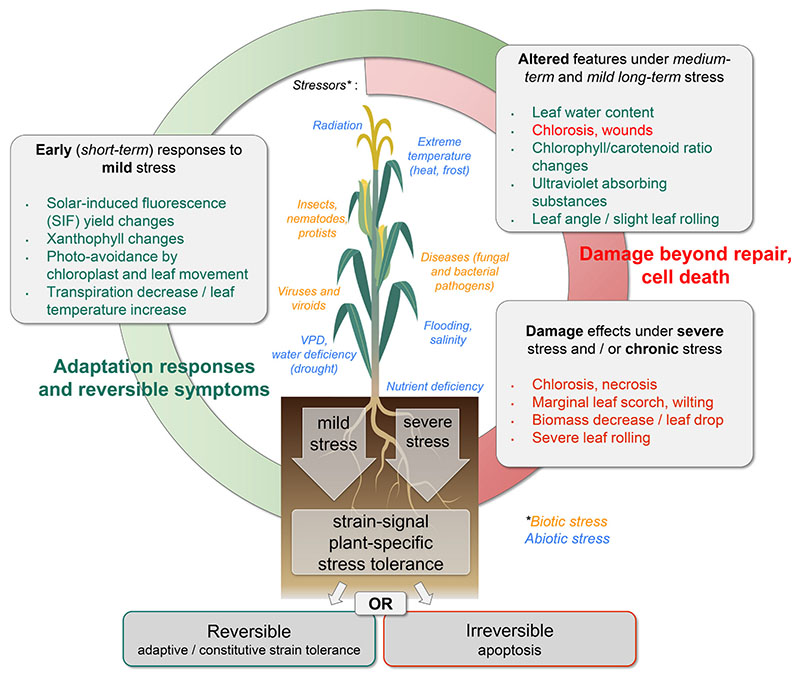
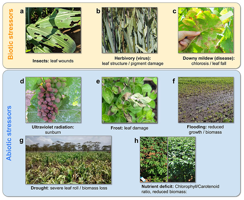
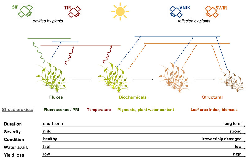
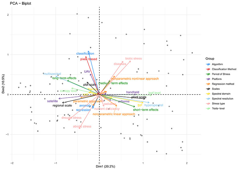
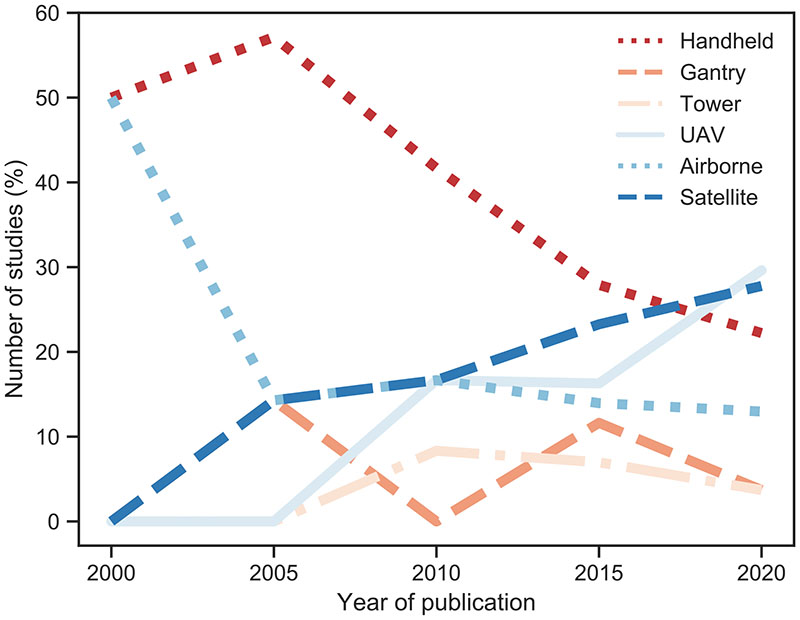
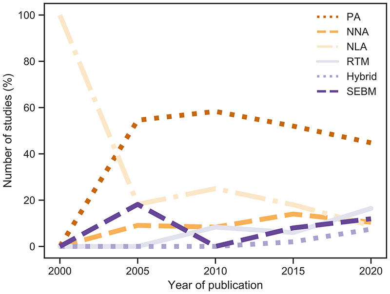
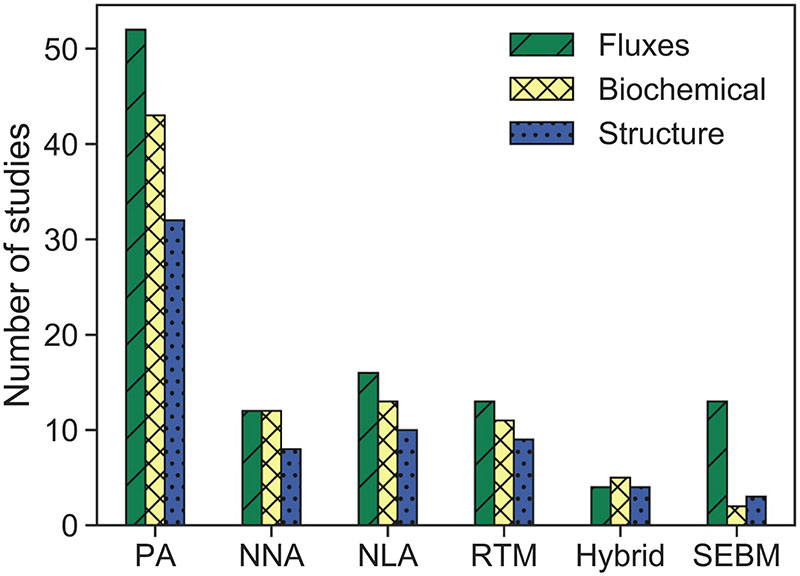
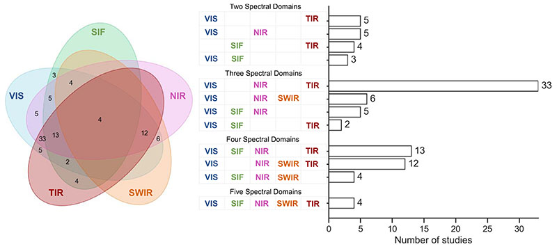
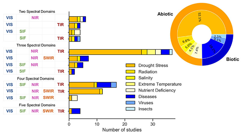
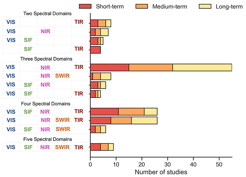
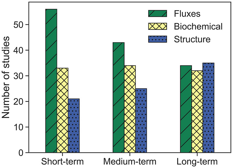
Remote detection and monitoring of the vegetation responses to stress became relevant for sustainable agriculture. Ongoing developments in optical remote sensing technologies have provided tools to increase our understanding of stress-related physiological processes. Therefore, this study aimed to provide an overview of the main spectral technologies and retrieval approaches for detecting crop stress in agriculture. Firstly, we present integrated views on: i) biotic and abiotic stress factors, the phases of stress, and respective plant responses, and ii) the affected traits, appropriate spectral domains and corresponding methods for measuring traits remotely. Secondly, representative results of a systematic literature analysis are highlighted, identifying the current status and possible future trends in stress detection and monitoring. Distinct plant responses occurring under shortterm, medium-term or severe chronic stress exposure can be captured with remote sensing due to specific light interaction processes, such as absorption and scattering manifested in the reflected radiance, i.e. visible (VIS), near infrared (NIR), shortwave infrared, and emitted radiance, i.e. solar-induced fluorescence and thermal infrared (TIR). From the analysis of 96 research papers, the following trends can be observed: increasing usage of satellite and unmanned aerial vehicle data in parallel with a shift in methods from simpler parametric approaches towards more advanced physically-based and hybrid models. Most study designs were largely driven by sensor availability and practical economic reasons, leading to the common usage of VIS-NIR-TIR sensor combinations. The majority of reviewed studies compared stress proxies calculated from single-source sensor domains rather than using data in a synergistic way. We identified new ways forward as guidance for improved synergistic usage of spectral domains for stress detection: (1) combined acquisition of data from multiple sensors for analysing multiple stress responses simultaneously (holistic view); (2) simultaneous retrieval of plant traits combining multi-domain radiative transfer models and machine learning methods; (3) assimilation of estimated plant traits from distinct spectral domains into integrated crop growth models. As a future outlook, we recommend combining multiple remote sensing data streams into crop model assimilation schemes to build up Digital Twins of agroecosystems, which may provide the most efficient way to detect the diversity of environmental and biotic stresses and thus enable respective management decisions.
对植被胁迫响应的远程检测和监测对可持续农业具有重要意义。光学遥感技术的不断发展提供了工具,以增进我们对与胁迫相关的生理过程的理解。因此,本研究旨在概述用于检测农业作物胁迫的主要光谱技术和反演方法。首先,我们给出关于以下方面的综合观点:i)生物和非生物胁迫因素、胁迫阶段以及相应的植物响应,ii)受影响的性状、合适的光谱域以及用于远程测量性状的相应方法。其次,突出了系统文献分析的代表性结果,确定了胁迫检测和监测的当前状况以及可能的未来趋势。由于特定的光相互作用过程,如反射辐射(即可见光(VIS)、近红外(NIR)、短波红外)和发射辐射(即太阳诱导荧光和热红外(TIR))中表现出的吸收和散射,在短期、中期或严重慢性胁迫暴露下发生的不同植物响应可以通过遥感来捕捉。通过对96篇研究论文的分析,可以观察到以下趋势:卫星和无人机数据的使用增加,同时方法从更简单的参数方法转向更先进的基于物理的和混合模型。大多数研究设计在很大程度上受传感器可用性和实际经济原因驱动,导致VIS-NIR-TIR传感器组合的普遍使用。大多数综述研究比较了从单源传感器域计算的胁迫代理,而不是以协同方式使用数据。我们确定了新的前进方向,作为改进光谱域协同用于胁迫检测的指导:(1)从多个传感器联合采集数据,以同时分析多种胁迫响应(整体观点);(2)结合多域辐射传输模型和机器学习方法同时反演植物性状;(3)将不同光谱域估计的植物性状同化到综合作物生长模型中。作为未来展望,我们建议将多个遥感数据流组合到作物模型同化方案中,以构建农业生态系统的数字孪生体,这可能提供检测环境和生物胁迫多样性的最有效方法,从而实现相应的管理决策。