Department of Remote Sensing, Institute for Geography and Geology, Julius-Maximilians University of Würzburg, Oswald-Külpe-Weg 86, 97074 Würzburg, Germany.
Department of Photogrammetry and Remote Sensing, Faculty of Geodesy and Geomatics Engineering, K. N. Toosi University of Technology, Teheran P.O. Box 15433-19967, Iran.
Sensors (Basel). 2022 Dec 29;23(1):349. doi: 10.3390/s23010349.
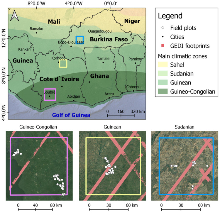
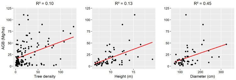
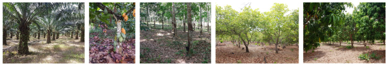
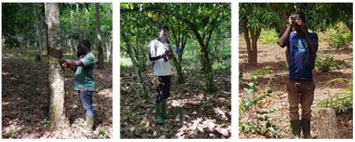
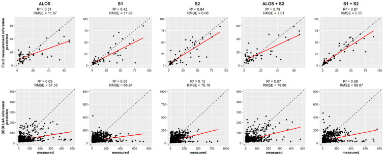
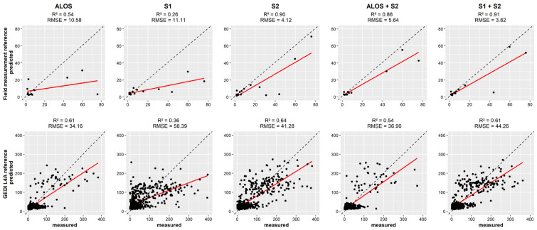
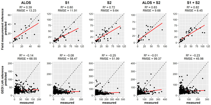
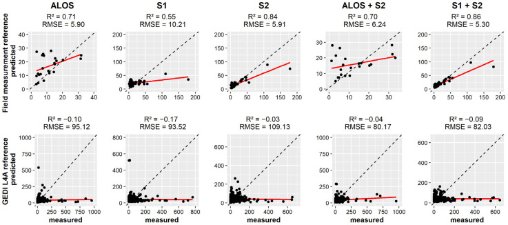
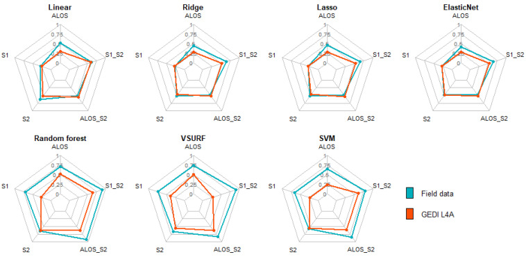
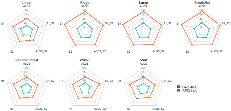
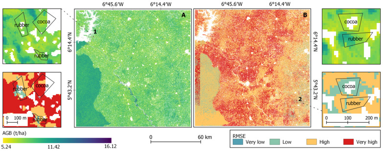
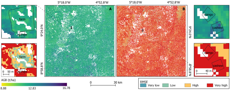
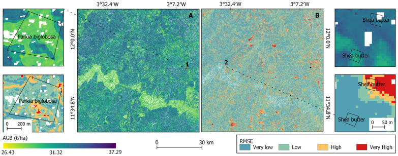
Agroforestry systems (AFS) offer viable solutions for climate change because of the aboveground biomass (AGB) that is maintained by the tree component. Therefore, spatially explicit estimation of their AGB is crucial for reporting emission reduction efforts, which can be enabled using remote sensing (RS) data and methods. However, multiple factors including the spatial distributions within the AFS, their structure, their composition, and their variable extents hinder an accurate RS-assisted estimation of the AGB across AFS. The aim of this study is to (i) evaluate the potential of spaceborne optical, SAR and LiDAR data for AGB estimations in AFS and (ii) estimate the AGB of different AFS in various climatic regions. The study was carried out in three climatic regions covering Côte d'Ivoire and Burkina Faso. Two AGB reference data sources were assessed: (i) AGB estimations derived from field measurements using allometric equations and (ii) AGB predictions from the GEDI level 4A (L4A) product. Vegetation indices and texture parameters were generated from optical (Sentinel-2) and SAR data (Sentinel-1 and ALOS-2) respectively and were used as predictors. Machine learning regression models were trained and evaluated by means of the coefficient of determination (R) and the RMSE. It was found that the prediction error was reduced by 31.2% after the stratification based on the climatic conditions. For the AGB prediction, the combination of random forest algorithm and Sentinel-1 and -2 data returned the best score. The GEDI L4A product was applicable only in the Guineo-Congolian region, but the prediction error was approx. nine times higher than the ground truth. Moreover, the AGB level varied across AFS including cocoa (7.51 ± 0.6 Mg ha) and rubber (7.33 ± 0.33 Mg ha) in the Guineo-Congolian region, cashew (13.78 ± 0.98 Mg ha) and mango (12.82 ± 0.65 Mg ha) in the Guinean region. The AFS farms in the Sudanian region showed the highest AGB level (6.59 to 82.11 Mg ha). AGB in an AFS was mainly determined by the diameter (R = 0.45), the height (R = 0.13) and the tree density (R = 0.10). Nevertheless, RS-based estimation of AGB remain challenging because of the spectral similarities between AFS. Therefore, spatial assessment of the prediction uncertainties should complement AGB maps in AFS.
农林复合系统 (AFS) 通过树木部分维持地上生物量 (AGB),为应对气候变化提供了可行的解决方案。因此,对其 AGB 进行空间显式估计对于报告减排工作至关重要,而这可以利用遥感 (RS) 数据和方法来实现。然而,包括 AFS 内的空间分布、结构、组成和可变范围在内的多种因素,阻碍了对 AFS 内 AGB 的准确 RS 辅助估计。本研究的目的是:(i) 评估星载光学、SAR 和 LiDAR 数据在 AFS 中进行 AGB 估计的潜力,以及 (ii) 估计不同气候区的不同 AFS 的 AGB。该研究在科特迪瓦和布基纳法索的三个气候区进行。评估了两种 AGB 参考数据源:(i) 利用基于树木的回归方程从地面测量得出的 AGB 估计值,以及 (ii) GEDI 级别 4A (L4A) 产品的 AGB 预测值。从光学 (Sentinel-2) 和 SAR 数据 (Sentinel-1 和 ALOS-2) 分别生成植被指数和纹理参数,并将其用作预测因子。通过决定系数 (R) 和均方根误差 (RMSE) 对机器学习回归模型进行训练和评估。结果发现,基于气候条件的分层后,预测误差降低了 31.2%。对于 AGB 预测,随机森林算法与 Sentinel-1 和 -2 数据的结合产生了最佳分数。GEDI L4A 产品仅适用于几内亚-刚果地区,但预测误差比地面实况高出约九倍。此外,AGB 水平在包括科特迪瓦和布基纳法索的几内亚-刚果地区的可可(7.51±0.6 Mg ha)和橡胶(7.33±0.33 Mg ha)、几内亚地区的腰果(13.78±0.98 Mg ha)和芒果(12.82±0.65 Mg ha)以及苏丹地区的农林复合系统农场(6.59 至 82.11 Mg ha)中存在差异。农林复合系统农场的 AGB 主要由直径(R = 0.45)、高度(R = 0.13)和树木密度(R = 0.10)决定。然而,由于 AFS 之间的光谱相似性,基于 RS 的 AGB 估计仍然具有挑战性。因此,应通过空间评估预测不确定性来补充 AFS 中的 AGB 地图。