• 文献检索
  • 文档翻译
  • 深度研究
  • 学术资讯
  • Suppr Zotero 插件Zotero 插件
  • 邀请有礼
  • 套餐&价格
  • 历史记录
应用&插件
Suppr Zotero 插件Zotero 插件浏览器插件Mac 客户端Windows 客户端微信小程序
定价
高级版会员购买积分包购买API积分包
服务
文献检索文档翻译深度研究API 文档MCP 服务
关于我们
关于 Suppr公司介绍联系我们用户协议隐私条款
关注我们

Suppr 超能文献

核心技术专利:CN118964589B侵权必究
粤ICP备2023148730 号-1Suppr @ 2026

文献检索

告别复杂PubMed语法,用中文像聊天一样搜索,搜遍4000万医学文献。AI智能推荐,让科研检索更轻松。

立即免费搜索

文件翻译

保留排版,准确专业,支持PDF/Word/PPT等文件格式,支持 12+语言互译。

免费翻译文档

深度研究

AI帮你快速写综述,25分钟生成高质量综述,智能提取关键信息,辅助科研写作。

立即免费体验

使用机器学习算法的土地利用与土地覆盖(LULC)性能建模:以澳大利亚墨尔本市为例

Land use and land cover (LULC) performance modeling using machine learning algorithms: a case study of the city of Melbourne, Australia.

作者信息

Aryal Jagannath, Sitaula Chiranjibi, Frery Alejandro C

机构信息

Earth Observation and AI Research Group, Department of Infrastructure Engineering, The University of Melbourne, Melbourne, 3053, Australia.

School of Mathematics and Statistics, Victoria University of Wellington, Wellington, 6012, New Zealand.

出版信息

Sci Rep. 2023 Aug 19;13(1):13510. doi: 10.1038/s41598-023-40564-0.

DOI:10.1038/s41598-023-40564-0
PMID:37598272
原文链接:https://pmc.ncbi.nlm.nih.gov/articles/PMC10439905/
Abstract

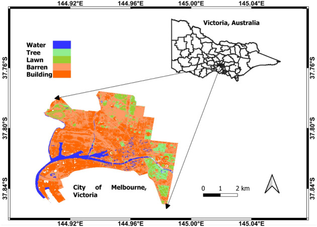
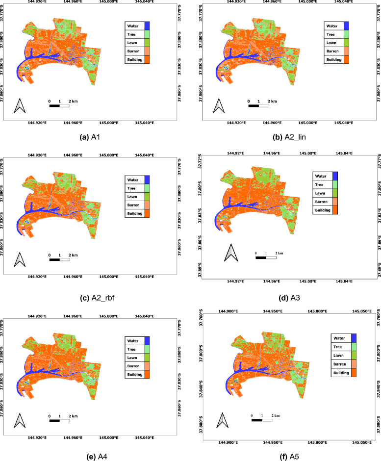
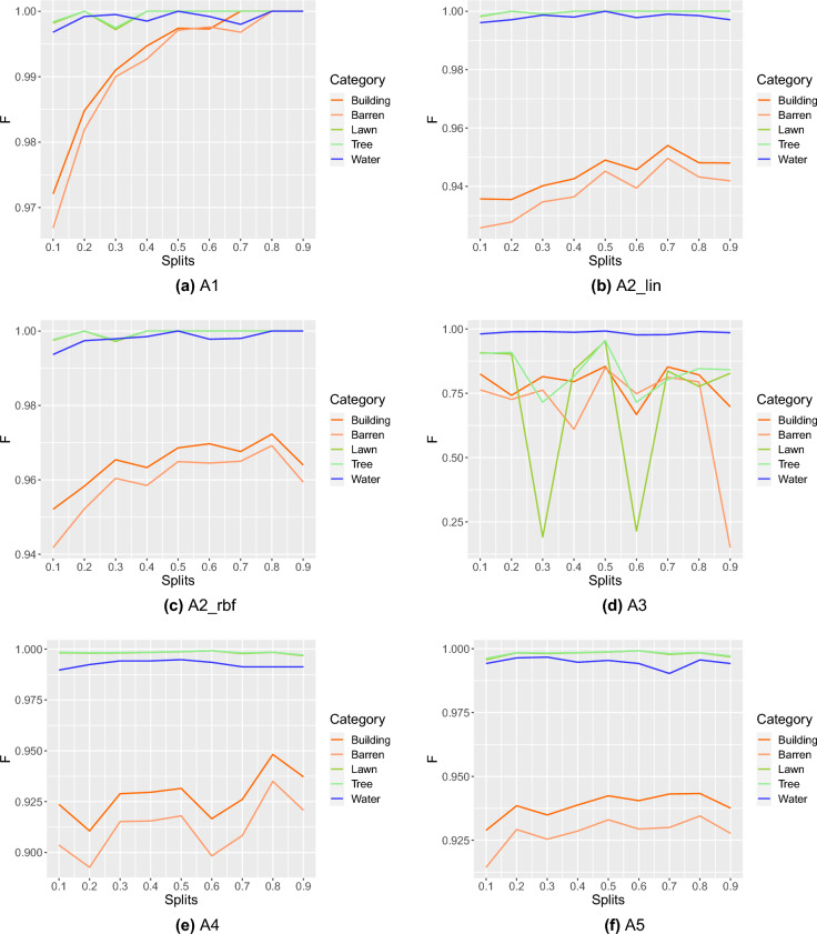
Accurate spatial information on Land use and land cover (LULC) plays a crucial role in city planning. A widely used method of obtaining accurate LULC maps is a classification of the categories, which is one of the challenging problems. Attempts have been made considering spectral (Sp), statistical (St), and index-based (Ind) features in developing LULC maps for city planning. However, no work has been reported to automate LULC performance modeling for their robustness with machine learning (ML) algorithms. In this paper, we design seven schemes and automate the LULC performance modeling with six ML algorithms-Random Forest, Support Vector Machine with Linear kernel, Support Vector Machine with Radial basis function kernel, Artificial Neural Network, Naïve Bayes, and Generalised Linear Model for the city of Melbourne, Australia on Sentinel-2A images. Experimental results show that the Random Forest outperforms remaining ML algorithms in the classification accuracy (0.99) on all schemes. The robustness and statistical analysis of the ML algorithms (for example, Random Forest imparts over 0.99 F1-score for all five categories and p value [Formula: see text] 0.05 from Wilcoxon ranked test over accuracy measures) against varying training splits demonstrate the effectiveness of the proposed schemes. Thus, providing a robust measure of LULC maps in city planning.

摘要

准确的土地利用和土地覆盖(LULC)空间信息在城市规划中起着至关重要的作用。一种广泛使用的获取准确LULC地图的方法是对类别进行分类,这是一个具有挑战性的问题之一。在为城市规划开发LULC地图时,人们已经尝试考虑光谱(Sp)、统计(St)和基于指数(Ind)的特征。然而,尚未有工作报道利用机器学习(ML)算法对LULC性能建模进行自动化以提高其稳健性。在本文中,我们设计了七种方案,并利用六种ML算法——随机森林、线性核支持向量机、径向基函数核支持向量机、人工神经网络、朴素贝叶斯和广义线性模型,对澳大利亚墨尔本的哨兵 - 2A图像进行LULC性能建模自动化。实验结果表明,在所有方案中,随机森林在分类精度(0.99)方面优于其余ML算法。针对不同训练分割的ML算法的稳健性和统计分析(例如,随机森林在所有五个类别上的F1分数超过0.99,并且在准确性度量上通过威尔科克森秩和检验得到的p值[公式:见正文] < 0.05)证明了所提方案的有效性。因此,为城市规划中的LULC地图提供了一种稳健的度量方法。

https://cdn.ncbi.nlm.nih.gov/pmc/blobs/bd11/10439905/aea2939f9ba5/41598_2023_40564_Fig5_HTML.jpg
https://cdn.ncbi.nlm.nih.gov/pmc/blobs/bd11/10439905/e38ec265a0d3/41598_2023_40564_Fig1_HTML.jpg
https://cdn.ncbi.nlm.nih.gov/pmc/blobs/bd11/10439905/615b73ef664d/41598_2023_40564_Fig2_HTML.jpg
https://cdn.ncbi.nlm.nih.gov/pmc/blobs/bd11/10439905/3e2d90c13aac/41598_2023_40564_Fig3_HTML.jpg
https://cdn.ncbi.nlm.nih.gov/pmc/blobs/bd11/10439905/46fbcc6c4887/41598_2023_40564_Fig4_HTML.jpg
https://cdn.ncbi.nlm.nih.gov/pmc/blobs/bd11/10439905/aea2939f9ba5/41598_2023_40564_Fig5_HTML.jpg

相似文献

1
Land use and land cover (LULC) performance modeling using machine learning algorithms: a case study of the city of Melbourne, Australia.使用机器学习算法的土地利用与土地覆盖(LULC)性能建模:以澳大利亚墨尔本市为例
Sci Rep. 2023 Aug 19;13(1):13510. doi: 10.1038/s41598-023-40564-0.
2
Use of machine learning-based classification algorithms in the monitoring of Land Use and Land Cover practices in a hilly terrain.基于机器学习的分类算法在丘陵地形土地利用和土地覆盖监测中的应用。
Environ Monit Assess. 2023 Dec 5;196(1):8. doi: 10.1007/s10661-023-12131-7.
3
A spatiotemporal ensemble machine learning framework for generating land use/land cover time-series maps for Europe (2000-2019) based on LUCAS, CORINE and GLAD Landsat.基于 LUCAS、CORINE 和 GLAD Landsat 数据,为欧洲(2000-2019 年)生成土地利用/土地覆盖时间序列地图的时空集成机器学习框架
PeerJ. 2022 Jul 21;10:e13573. doi: 10.7717/peerj.13573. eCollection 2022.
4
Generating high-resolution land use and land cover maps for the greater Mariño watershed in 2019 with machine learning.2019年利用机器学习生成大马里尼奥流域的高分辨率土地利用和土地覆盖地图。
Sci Data. 2024 Aug 23;11(1):915. doi: 10.1038/s41597-024-03750-x.
5
Decadal Trend in Agricultural Abandonment and Woodland Expansion in an Agro-Pastoral Transition Band in Northern China.中国北方农牧交错带农业弃耕与林地扩张的年代际趋势
PLoS One. 2015 Nov 12;10(11):e0142113. doi: 10.1371/journal.pone.0142113. eCollection 2015.
6
Mapping and monitoring land use land cover dynamics employing Google Earth Engine and machine learning algorithms on Chattogram, Bangladesh.利用谷歌地球引擎和机器学习算法对孟加拉国吉大港市的土地利用土地覆盖动态进行测绘和监测。
Heliyon. 2023 Oct 24;9(11):e21245. doi: 10.1016/j.heliyon.2023.e21245. eCollection 2023 Nov.
7
Demi-decadal land use land cover change analysis of Mizoram, India, with topographic correction using machine learning algorithm.印度米佐拉姆邦的半十年土地利用/土地覆盖变化分析,使用机器学习算法进行地形校正。
Environ Sci Pollut Res Int. 2024 May;31(21):30569-30591. doi: 10.1007/s11356-024-33094-3. Epub 2024 Apr 12.
8
Analysis of land use and land cover change using machine learning algorithm in Yola North Local Government Area of Adamawa State, Nigeria.使用机器学习算法分析尼日利亚阿达马瓦州约拉北部地方政府地区的土地利用和土地覆盖变化。
Environ Monit Assess. 2023 Nov 14;195(12):1470. doi: 10.1007/s10661-023-12112-w.
9
Quantitative assessment of Land use/land cover changes in a developing region using machine learning algorithms: A case study in the Kurdistan Region, Iraq.使用机器学习算法对发展中地区土地利用/土地覆盖变化进行定量评估:以伊拉克库尔德斯坦地区为例
Heliyon. 2023 Oct 24;9(11):e21253. doi: 10.1016/j.heliyon.2023.e21253. eCollection 2023 Nov.
10
Land-Use and Land-Cover Classification in Semi-Arid Areas from Medium-Resolution Remote-Sensing Imagery: A Deep Learning Approach.半干旱地区中分辨率遥感影像的土地利用/土地覆盖分类:深度学习方法。
Sensors (Basel). 2022 Nov 12;22(22):8750. doi: 10.3390/s22228750.

引用本文的文献

1
Land use and land cover classification and terrestrial ecosystem carbon storage changes in Vietnam based on Sentinel images.基于哨兵影像的越南土地利用与土地覆盖分类及陆地生态系统碳储量变化
Sci Rep. 2025 Jul 1;15(1):22114. doi: 10.1038/s41598-025-04765-z.
2
Insights into the linkages of forest structure dynamics with ecosystem services.对森林结构动态与生态系统服务之间联系的洞察。
Sci Rep. 2025 May 4;15(1):15606. doi: 10.1038/s41598-025-00167-3.
3
Leveraging U-Net and selective feature extraction for land cover classification using remote sensing imagery.

本文引用的文献

1
Deep Learning-Based Methods for Sentiment Analysis on Nepali COVID-19-Related Tweets.基于深度学习的尼泊尔新冠相关推文情感分析方法。
Comput Intell Neurosci. 2021 Nov 1;2021:2158184. doi: 10.1155/2021/2158184. eCollection 2021.
2
Multimodal remote sensing benchmark datasets for land cover classification with a shared and specific feature learning model.用于土地覆盖分类的多模态遥感基准数据集,采用共享和特定特征学习模型。
ISPRS J Photogramm Remote Sens. 2021 Aug;178:68-80. doi: 10.1016/j.isprsjprs.2021.05.011.
3
Land use and land cover change detection and spatial distribution on the Tibetan Plateau.
利用U-Net和选择性特征提取进行基于遥感影像的土地覆盖分类
Sci Rep. 2025 Jan 4;15(1):784. doi: 10.1038/s41598-024-84795-1.
青藏高原土地利用/土地覆盖变化检测与空间分布。
Sci Rep. 2021 Apr 6;11(1):7531. doi: 10.1038/s41598-021-87215-w.
4
Urban Land Use and Land Cover Classification Using Novel Deep Learning Models Based on High Spatial Resolution Satellite Imagery.基于高空间分辨率卫星图像的新型深度学习模型在城市土地利用和土地覆盖分类中的应用。
Sensors (Basel). 2018 Nov 1;18(11):3717. doi: 10.3390/s18113717.