• 文献检索
  • 文档翻译
  • 深度研究
  • 学术资讯
  • Suppr Zotero 插件Zotero 插件
  • 邀请有礼
  • 套餐&价格
  • 历史记录
应用&插件
Suppr Zotero 插件Zotero 插件浏览器插件Mac 客户端Windows 客户端微信小程序
定价
高级版会员购买积分包购买API积分包
服务
文献检索文档翻译深度研究API 文档MCP 服务
关于我们
关于 Suppr公司介绍联系我们用户协议隐私条款
关注我们

Suppr 超能文献

核心技术专利:CN118964589B侵权必究
粤ICP备2023148730 号-1Suppr @ 2026

文献检索

告别复杂PubMed语法,用中文像聊天一样搜索,搜遍4000万医学文献。AI智能推荐,让科研检索更轻松。

立即免费搜索

文件翻译

保留排版,准确专业,支持PDF/Word/PPT等文件格式,支持 12+语言互译。

免费翻译文档

深度研究

AI帮你快速写综述,25分钟生成高质量综述,智能提取关键信息,辅助科研写作。

立即免费体验

基于机器学习的空间数据开发,用于优化印度尼西亚的天文观测站选址。

Machine learning-based spatial data development for optimizing astronomical observatory sites in Indonesia.

机构信息

Remote Sensing and Geographic Information Science Research Group, Faculty of Earth Sciences and Technology, Institut Teknologi Bandung, Bandung, Indonesia.

Center for Remote Sensing, Institut Teknologi Bandung, Bandung, Indonesia.

出版信息

PLoS One. 2023 Oct 20;18(10):e0293190. doi: 10.1371/journal.pone.0293190. eCollection 2023.

DOI:10.1371/journal.pone.0293190
PMID:37862376
原文链接:https://pmc.ncbi.nlm.nih.gov/articles/PMC10588834/
Abstract

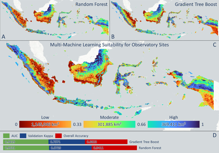
Astronomical observatory construction plays an essential role in astronomy research, education, and tourism development worldwide. This study develops siting distribution scenarios for astronomical observatory locations in Indonesia using a suitability analysis by integrating the physical and atmospheric observatory suitability indexes, machine learning models, and long-term climate models. Subsequently, potential sites are equalized based on longitude and latitude zonal divisions considering air pollution disturbance risks. The study novelty comes from the integrated model development of physical and socio-economic factors, dynamic spatiotemporal analysis of atmospheric factors, and the consideration of equitable low air-pollution-disturbance-risk distribution in optimal country-level observatory construction scenarios. Generally, Indonesia comprises high suitability index and low multi-source air pollution risk areas, although some area has high astronomical suitability and high-medium air pollution risk. Most of Java, the east coast of Sumatra, and the west and south coasts of Kalimantan demonstrate "low astronomical suitability-high air pollution risk." A total of eighteen locations are recommended for new observatories, of which five, one, three, four, two, and three are on Sumatra, Java, Kalimantan, Nusa Tenggara, Sulawesi, and Papua, respectively. This study provides a comprehensive approach to determine the optimal observatory construction site to optimize the potential of astronomical activities.

摘要

天文观测站的建设在全球范围内的天文学研究、教育和旅游发展中起着至关重要的作用。本研究通过整合物理和大气观测站适宜性指数、机器学习模型和长期气候模型,对印度尼西亚的天文观测站位置进行选址分布情景开发,采用适宜性分析。随后,根据考虑空气污染干扰风险的经度和纬度带分区,对潜在站点进行均衡化处理。本研究的新颖之处在于综合考虑了物理和社会经济因素的模型开发、大气因素的动态时空分析以及在最优的国家级观测站建设方案中考虑公平的低空气污染干扰风险分布。一般来说,印度尼西亚既有高适宜性指数和低多源空气污染风险地区,也有一些地区具有高天文适宜性和高中等空气污染风险。爪哇岛大部分地区、苏门答腊岛东海岸以及加里曼丹岛西海岸和南岸都表现出“低天文适宜性-高空气污染风险”的特征。共推荐了 18 个新观测站的位置,其中苏门答腊岛、爪哇岛、加里曼丹岛、努沙登加拉岛、苏拉威西岛和巴布亚岛分别有 5、1、3、4、2 和 3 个观测站。本研究提供了一种综合方法来确定最佳观测站建设地点,以优化天文活动的潜力。

https://cdn.ncbi.nlm.nih.gov/pmc/blobs/f379/10588834/60a07cac9bc2/pone.0293190.g012.jpg
https://cdn.ncbi.nlm.nih.gov/pmc/blobs/f379/10588834/efcc4eb58928/pone.0293190.g001.jpg
https://cdn.ncbi.nlm.nih.gov/pmc/blobs/f379/10588834/9d36d82077e7/pone.0293190.g002.jpg
https://cdn.ncbi.nlm.nih.gov/pmc/blobs/f379/10588834/34d61c4f1884/pone.0293190.g003.jpg
https://cdn.ncbi.nlm.nih.gov/pmc/blobs/f379/10588834/c7c73ecf1ce7/pone.0293190.g004.jpg
https://cdn.ncbi.nlm.nih.gov/pmc/blobs/f379/10588834/466b53d39563/pone.0293190.g005.jpg
https://cdn.ncbi.nlm.nih.gov/pmc/blobs/f379/10588834/b89b01a8d989/pone.0293190.g006.jpg
https://cdn.ncbi.nlm.nih.gov/pmc/blobs/f379/10588834/8f29f61a35e9/pone.0293190.g007.jpg
https://cdn.ncbi.nlm.nih.gov/pmc/blobs/f379/10588834/9b29a39903ee/pone.0293190.g008.jpg
https://cdn.ncbi.nlm.nih.gov/pmc/blobs/f379/10588834/8f07fc718366/pone.0293190.g009.jpg
https://cdn.ncbi.nlm.nih.gov/pmc/blobs/f379/10588834/767ff75a5e5a/pone.0293190.g010.jpg
https://cdn.ncbi.nlm.nih.gov/pmc/blobs/f379/10588834/af39a6f30f7c/pone.0293190.g011.jpg
https://cdn.ncbi.nlm.nih.gov/pmc/blobs/f379/10588834/60a07cac9bc2/pone.0293190.g012.jpg

相似文献

1
Machine learning-based spatial data development for optimizing astronomical observatory sites in Indonesia.基于机器学习的空间数据开发,用于优化印度尼西亚的天文观测站选址。
PLoS One. 2023 Oct 20;18(10):e0293190. doi: 10.1371/journal.pone.0293190. eCollection 2023.
2
Bowie gen. nov., a diverse lineage of ground-dwelling spiders occurring from the Himalayas to Papua New Guinea and northern Australia (Araneae: Ctenidae: Cteninae).鲍威氏属,一个多样的穴居蜘蛛谱系,分布于喜马拉雅山脉至巴布亚新几内亚和澳大利亚北部(蜘蛛目:球蛛科:栉足蛛亚科)。
Zootaxa. 2022 Aug 4;5170(1):1-200. doi: 10.11646/zootaxa.5170.1.1.
3
Prevalence and Distribution of Rotavirus Genotypes Among Children With Acute Gastroenteritis in Areas Other Than Java Island, Indonesia, 2016-2018.2016 - 2018年印度尼西亚爪哇岛以外地区急性胃肠炎儿童中轮状病毒基因型的流行情况和分布
Front Microbiol. 2021 May 6;12:672837. doi: 10.3389/fmicb.2021.672837. eCollection 2021.
4
Forest cover and climate as potential drivers for dengue fever in Sumatra and Kalimantan 2006-2016: a spatiotemporal analysis.森林覆盖和气候作为 2006-2016 年苏门答腊和加里曼丹登革热的潜在驱动因素:时空分析。
Trop Med Int Health. 2019 Jul;24(7):888-898. doi: 10.1111/tmi.13248. Epub 2019 Jun 3.
5
Spatiotemporal Characterization of Dengue Incidence and Its Correlation to Climate Parameters in Indonesia.印度尼西亚登革热发病率的时空特征及其与气候参数的相关性
Insects. 2024 May 17;15(5):366. doi: 10.3390/insects15050366.
6
Measurements of sky brightness at Bosscha Observatory, Indonesia.印度尼西亚博斯查天文台的天空亮度测量。
Heliyon. 2020 Aug 19;6(8):e04635. doi: 10.1016/j.heliyon.2020.e04635. eCollection 2020 Aug.
7
Challenges for control of taeniasis/cysticercosis in Indonesia.印度尼西亚控制绦虫病/囊尾蚴病面临的挑战。
Parasitol Int. 2006;55 Suppl:S161-5. doi: 10.1016/j.parint.2005.11.025. Epub 2005 Dec 27.
8
Spatial differentiation and determinants of COVID-19 in Indonesia.印度尼西亚 COVID-19 的空间差异及其决定因素。
BMC Public Health. 2022 May 23;22(1):1030. doi: 10.1186/s12889-022-13316-4.
9
Rabies in the Dutch East Indies a century ago - a spatio-temporal case study in disease emergence.一个世纪前荷属东印度群岛的狂犬病——疾病出现的时空案例研究。
Prev Vet Med. 2014 Apr 1;114(1):11-20. doi: 10.1016/j.prevetmed.2014.01.009. Epub 2014 Jan 15.
10
Towards an Intelligent Observatory.迈向智能观测站
An Acad Bras Cienc. 2021 May 17;93(suppl 1):e20201026. doi: 10.1590/0001-3756202120201026. eCollection 2021.

引用本文的文献

1
Machine learning based urban sprawl assessment using integrated multi-hazard and environmental-economic impact.基于机器学习的城市扩张评估:综合多重灾害及环境经济影响
Sci Rep. 2024 Jun 11;14(1):13385. doi: 10.1038/s41598-024-62001-6.

本文引用的文献

1
Spatial integration framework of solar, wind, and hydropower energy potential in Southeast Asia.东南亚太阳能、风能和水能潜力的空间综合框架。
Sci Rep. 2023 Jan 7;13(1):340. doi: 10.1038/s41598-022-25570-y.
2
Multi-air pollution risk assessment in Southeast Asia region using integrated remote sensing and socio-economic data products.利用综合遥感和社会经济数据产品对东南亚地区进行多空气污染风险评估。
Sci Total Environ. 2023 Jan 1;854:158825. doi: 10.1016/j.scitotenv.2022.158825. Epub 2022 Sep 15.
3
The relationship between night-time light and socioeconomic factors in China and India.
中国和印度的夜间灯光与社会经济因素之间的关系。
PLoS One. 2022 Jan 13;17(1):e0262503. doi: 10.1371/journal.pone.0262503. eCollection 2022.
4
Predictive mapping of the global power system using open data.利用公开数据对全球电力系统进行预测性建模。
Sci Data. 2020 Jan 15;7(1):19. doi: 10.1038/s41597-019-0347-4.
5
Managing the middle: A shift in conservation priorities based on the global human modification gradient.管理中游地带:基于全球人类改造梯度的保护重点转移。
Glob Chang Biol. 2019 Mar;25(3):811-826. doi: 10.1111/gcb.14549. Epub 2019 Jan 10.
6
The new world atlas of artificial night sky brightness.新世界夜空亮度图集。
Sci Adv. 2016 Jun 10;2(6):e1600377. doi: 10.1126/sciadv.1600377. eCollection 2016 Jun.
7
Quantile-based classifiers.基于分位数的分类器。
Biometrika. 2016 Jun;103(2):435-446. doi: 10.1093/biomet/asw015. Epub 2016 May 23.
8
GIS-based groundwater potential mapping using boosted regression tree, classification and regression tree, and random forest machine learning models in Iran.基于地理信息系统(GIS),运用提升回归树、分类与回归树以及随机森林机器学习模型在伊朗进行地下水潜力制图。
Environ Monit Assess. 2016 Jan;188(1):44. doi: 10.1007/s10661-015-5049-6. Epub 2015 Dec 19.
9
The climate hazards infrared precipitation with stations--a new environmental record for monitoring extremes.气候危害与站点的红外降水——一种新的极端环境监测记录。
Sci Data. 2015 Dec 8;2:150066. doi: 10.1038/sdata.2015.66.
10
Night-Time Light Data: A Good Proxy Measure for Economic Activity?夜间灯光数据:经济活动的良好替代指标?
PLoS One. 2015 Oct 23;10(10):e0139779. doi: 10.1371/journal.pone.0139779. eCollection 2015.