Wang Jiayuan, Alli Abosede S, Clark Sierra N, Ezzati Majid, Brauer Michael, Hughes Allison F, Nimo James, Moses Josephine Bedford, Baah Solomon, Nathvani Ricky, D Vishwanath, Agyei-Mensah Samuel, Baumgartner Jill, Bennett James E, Arku Raphael E
Department of Environmental Health Sciences, School of Public Health and Health Sciences, University of Massachusetts, Amherst, MA, United States of America.
Department of Epidemiology and Biostatistics, School of Public Health, Imperial College London, London, United Kingdom.
Environ Res Lett. 2024 Mar 1;19(3):034036. doi: 10.1088/1748-9326/ad2892. Epub 2024 Feb 27.
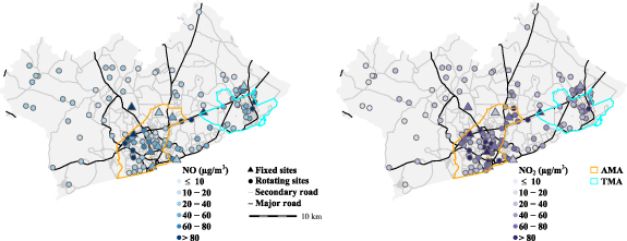
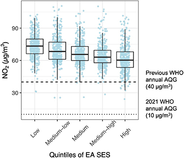
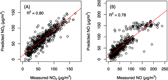
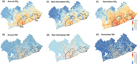
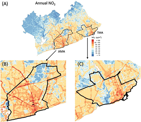
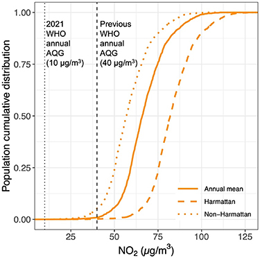
Road traffic has become the leading source of air pollution in fast-growing sub-Saharan African cities. Yet, there is a dearth of robust city-wide data for understanding space-time variations and inequalities in combustion related emissions and exposures. We combined nitrogen dioxide (NO) and nitric oxide (NO) measurement data from 134 locations in the Greater Accra Metropolitan Area (GAMA), with geographical, meteorological, and population factors in spatio-temporal mixed effects models to predict NO and NO concentrations at fine spatial (50 m) and temporal (weekly) resolution over the entire GAMA. Model performance was evaluated with 10-fold cross-validation (CV), and predictions were summarized as annual and seasonal (dusty [Harmattan] and rainy [non-Harmattan]) mean concentrations. The predictions were used to examine population distributions of, and socioeconomic inequalities in, exposure at the census enumeration area (EA) level. The models explained 88% and 79% of the spatiotemporal variability in NO and NO concentrations, respectively. The mean predicted annual, non-Harmattan and Harmattan NO levels were 37 (range: 1-189), 28 (range: 1-170) and 50 (range: 1-195) g m, respectively. Unlike NO, NO concentrations were highest in the non-Harmattan season (41 [range: 31-521] g m). Road traffic was the dominant factor for both pollutants, but NO had higher spatial heterogeneity than NO. For both pollutants, the levels were substantially higher in the city core, where the entire population (100%) was exposed to annual NO levels exceeding the World Health Organization (WHO) guideline of 10 g m. Significant disparities in NO concentrations existed across socioeconomic gradients, with residents in the poorest communities exposed to levels about 15 g m higher compared with the wealthiest ( < 0.001). The results showed the important role of road traffic emissions in air pollution concentrations in the GAMA, which has major implications for the health of the city's poorest residents. These data could support climate and health impact assessments as well as policy evaluations in the city.
在撒哈拉以南非洲快速发展的城市中,道路交通已成为空气污染的主要来源。然而,目前缺乏全面、可靠的城市范围数据,以了解与燃烧相关的排放和暴露的时空变化及不平等情况。我们将大阿克拉都会区(GAMA)134个地点的二氧化氮(NO₂)和一氧化氮(NO)测量数据,与地理、气象和人口因素相结合,纳入时空混合效应模型,以预测整个GAMA地区在精细空间分辨率(50米)和时间分辨率(每周)下的NO₂和NO浓度。通过10折交叉验证(CV)评估模型性能,并将预测结果总结为年度和季节性(沙尘季[哈马丹季]和雨季[非哈马丹季])平均浓度。这些预测结果用于研究人口普查枚举区(EA)层面的暴露人群分布以及社会经济不平等情况。模型分别解释了NO₂和NO浓度时空变异性的88%和79%。预测的年度、非哈马丹季和哈马丹季的平均NO₂水平分别为37(范围:1 - 189)μg/m³、28(范围:1 - 170)μg/m³和50(范围:1 - 195)μg/m³。与NO₂不同,NO浓度在非哈马丹季最高(41[范围:31 - 521]μg/m³)。道路交通是两种污染物的主要影响因素,但NO的空间异质性高于NO₂。对于这两种污染物,城市核心区域的浓度要高得多,该区域全部人口(100%)暴露的年度NO₂水平超过了世界卫生组织(WHO)10μg/m³的指导标准。不同社会经济梯度之间的NO₂浓度存在显著差异,最贫困社区的居民暴露水平比最富裕社区高出约15μg/m³(p < 0.001)。结果表明道路交通排放对GAMA地区空气污染浓度起着重要作用,这对该城市最贫困居民的健康具有重大影响。这些数据可为该城市的气候和健康影响评估以及政策评价提供支持。