• 文献检索
  • 文档翻译
  • 深度研究
  • 学术资讯
  • Suppr Zotero 插件Zotero 插件
  • 邀请有礼
  • 套餐&价格
  • 历史记录
应用&插件
Suppr Zotero 插件Zotero 插件浏览器插件Mac 客户端Windows 客户端微信小程序
定价
高级版会员购买积分包购买API积分包
服务
文献检索文档翻译深度研究API 文档MCP 服务
关于我们
关于 Suppr公司介绍联系我们用户协议隐私条款
关注我们

Suppr 超能文献

核心技术专利:CN118964589B侵权必究
粤ICP备2023148730 号-1Suppr @ 2026

文献检索

告别复杂PubMed语法,用中文像聊天一样搜索,搜遍4000万医学文献。AI智能推荐,让科研检索更轻松。

立即免费搜索

文件翻译

保留排版,准确专业,支持PDF/Word/PPT等文件格式,支持 12+语言互译。

免费翻译文档

深度研究

AI帮你快速写综述,25分钟生成高质量综述,智能提取关键信息,辅助科研写作。

立即免费体验

深度学习模型从公民科学和遥感数据中绘制快速的植物物种变化图。

Deep learning models map rapid plant species changes from citizen science and remote sensing data.

机构信息

Department of Plant Biology, Carnegie Science, Stanford, CA 94305.

Department of Computer Science, Stanford University, Stanford, CA 94305.

出版信息

Proc Natl Acad Sci U S A. 2024 Sep 10;121(37):e2318296121. doi: 10.1073/pnas.2318296121. Epub 2024 Sep 5.

DOI:10.1073/pnas.2318296121
PMID:39236239
原文链接:https://pmc.ncbi.nlm.nih.gov/articles/PMC11406280/
Abstract

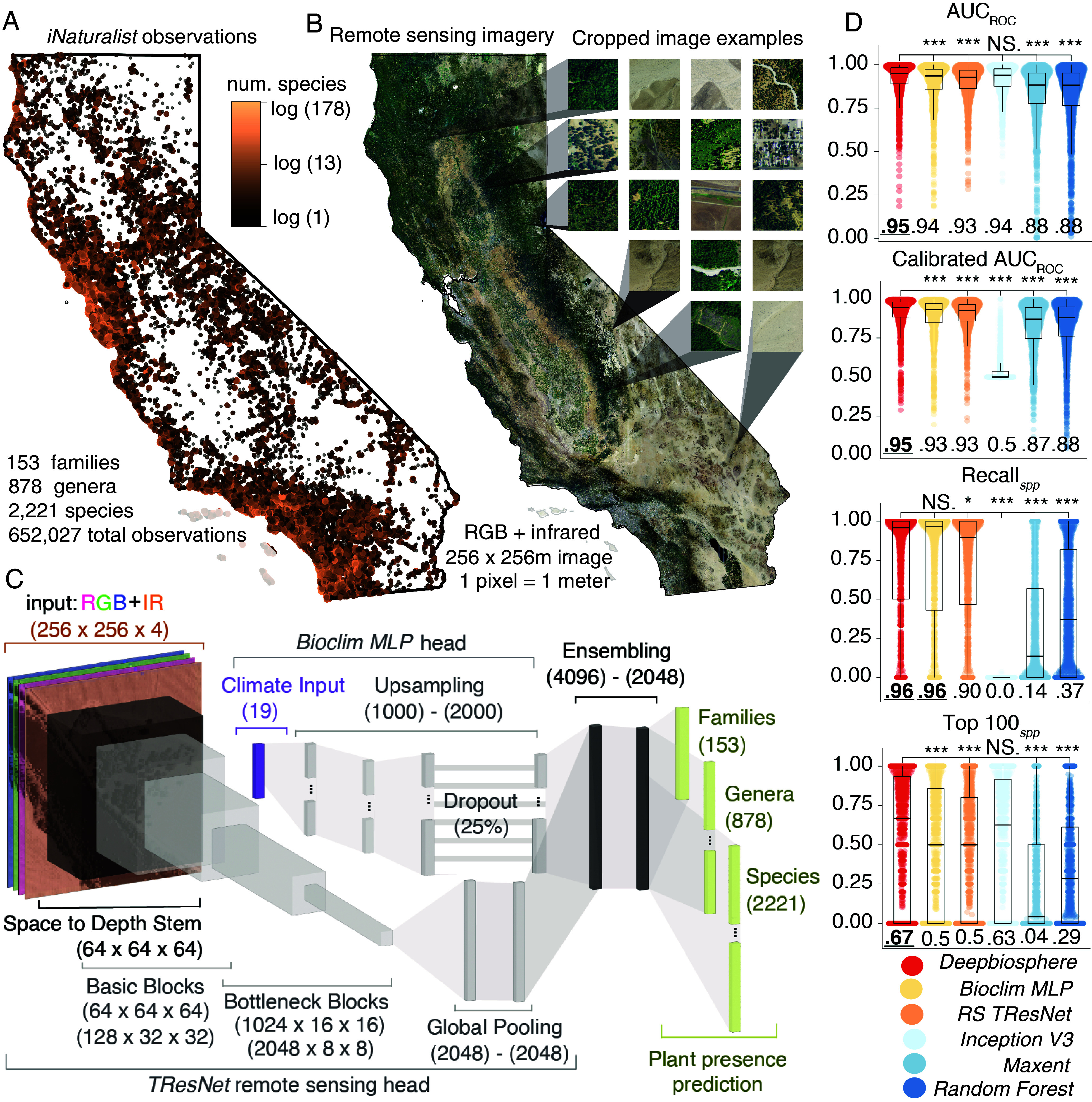
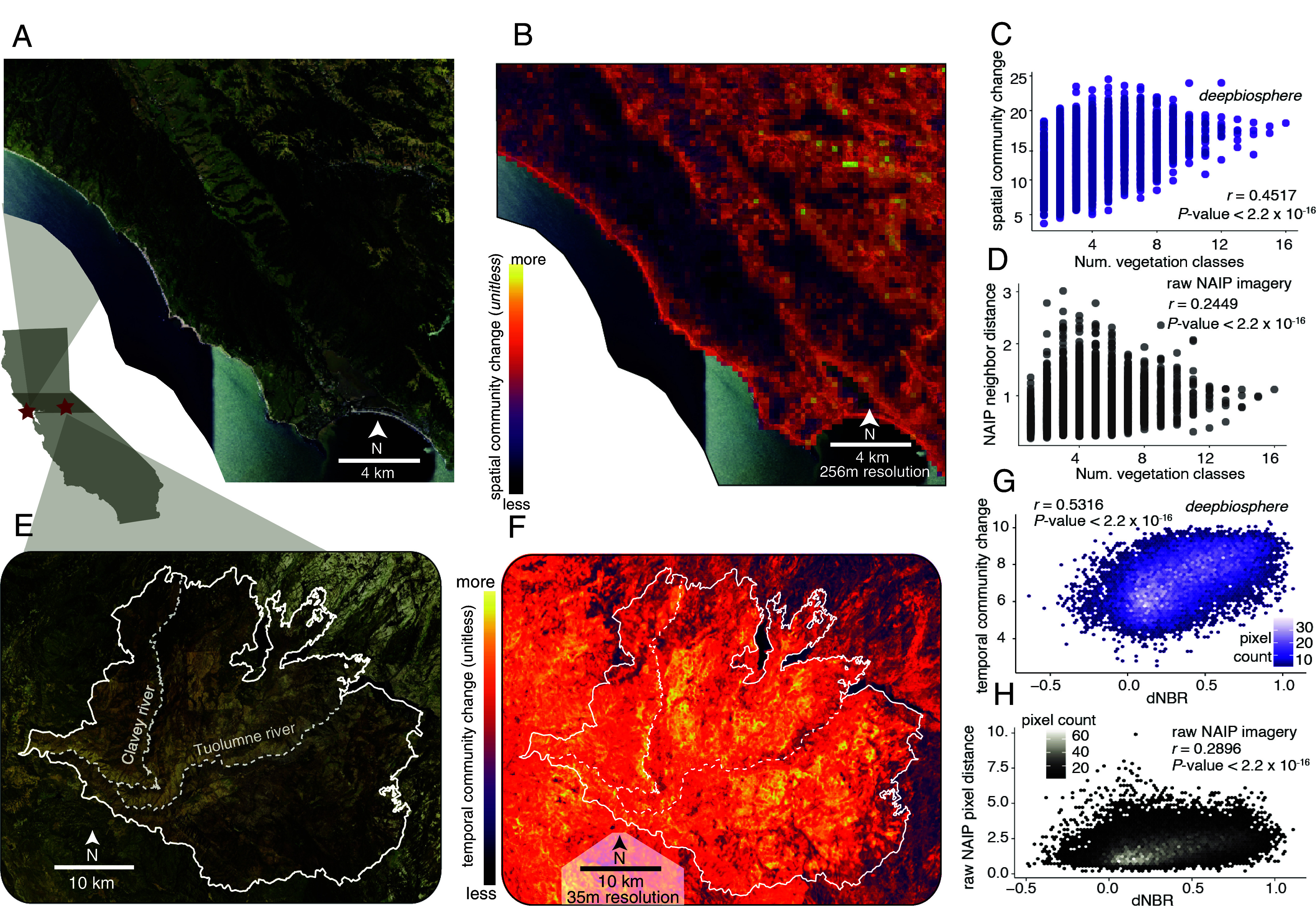
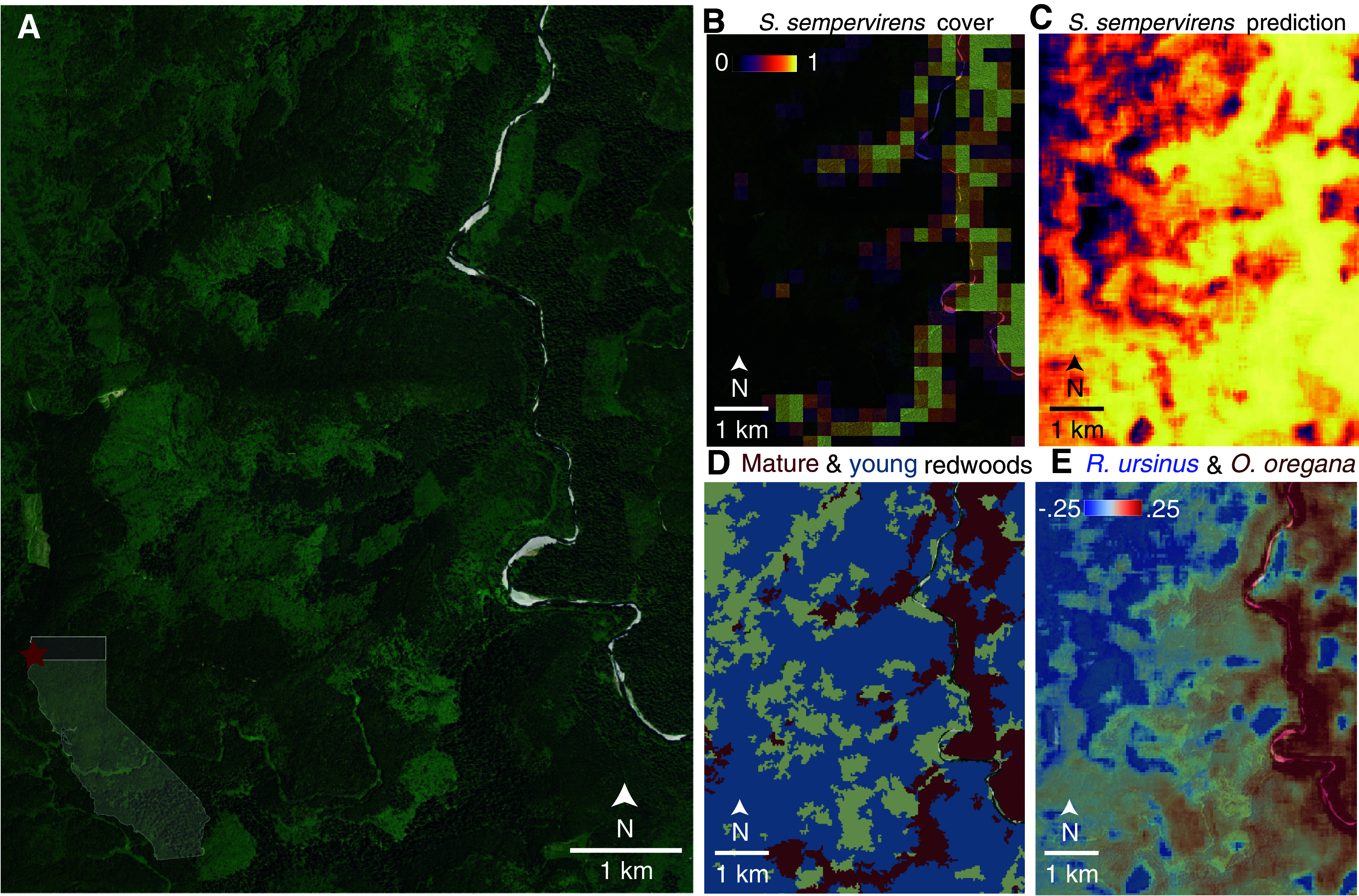
Anthropogenic habitat destruction and climate change are reshaping the geographic distribution of plants worldwide. However, we are still unable to map species shifts at high spatial, temporal, and taxonomic resolution. Here, we develop a deep learning model trained using remote sensing images from California paired with half a million citizen science observations that can map the distribution of over 2,000 plant species. Our model-not only outperforms many common species distribution modeling approaches (AUC 0.95 vs. 0.88) but can map species at up to a few meters resolution and finely delineate plant communities with high accuracy, including the pristine and clear-cut forests of Redwood National Park. These fine-scale predictions can further be used to map the intensity of habitat fragmentation and sharp ecosystem transitions across human-altered landscapes. In addition, from frequent collections of remote sensing data, can detect the rapid effects of severe wildfire on plant community composition across a 2-y time period. These findings demonstrate that integrating public earth observations and citizen science with deep learning can pave the way toward automated systems for monitoring biodiversity change in real-time worldwide.

摘要

人为的栖息地破坏和气候变化正在重塑全球植物的地理分布。然而,我们仍然无法以高时空和分类分辨率来绘制物种转移图。在这里,我们开发了一种深度学习模型,该模型使用加利福尼亚州的遥感图像和 50 万条公民科学观测数据进行训练,可以绘制 2000 多种植物物种的分布。我们的模型不仅优于许多常见的物种分布模型方法(AUC 为 0.95 对 0.88),而且可以以几米的分辨率绘制物种图,并以高精度精细划定植物群落,包括红杉国家公园的原始和砍伐后的森林。这些精细的预测结果可进一步用于绘制人类改造景观的栖息地破碎化和生态系统急剧转变的强度图。此外,通过频繁收集遥感数据,可以检测到在 2 年时间内野火对植物群落组成的快速影响。这些发现表明,将公共地球观测和公民科学与深度学习相结合,可以为实时全球生物多样性变化的自动监测系统铺平道路。

https://cdn.ncbi.nlm.nih.gov/pmc/blobs/cc25/11406280/738c4f36d82c/pnas.2318296121fig03.jpg
https://cdn.ncbi.nlm.nih.gov/pmc/blobs/cc25/11406280/2b966f5ea365/pnas.2318296121fig01.jpg
https://cdn.ncbi.nlm.nih.gov/pmc/blobs/cc25/11406280/a3bcd4da7c21/pnas.2318296121fig02.jpg
https://cdn.ncbi.nlm.nih.gov/pmc/blobs/cc25/11406280/738c4f36d82c/pnas.2318296121fig03.jpg
https://cdn.ncbi.nlm.nih.gov/pmc/blobs/cc25/11406280/2b966f5ea365/pnas.2318296121fig01.jpg
https://cdn.ncbi.nlm.nih.gov/pmc/blobs/cc25/11406280/a3bcd4da7c21/pnas.2318296121fig02.jpg
https://cdn.ncbi.nlm.nih.gov/pmc/blobs/cc25/11406280/738c4f36d82c/pnas.2318296121fig03.jpg

相似文献

1
Deep learning models map rapid plant species changes from citizen science and remote sensing data.深度学习模型从公民科学和遥感数据中绘制快速的植物物种变化图。
Proc Natl Acad Sci U S A. 2024 Sep 10;121(37):e2318296121. doi: 10.1073/pnas.2318296121. Epub 2024 Sep 5.
2
Mapping multi-scale vascular plant richness in a forest landscape with integrated LiDAR and hyperspectral remote-sensing.利用综合激光雷达和高光谱遥感技术绘制森林景观中多尺度维管植物丰富度图谱。
Ecology. 2018 Feb;99(2):474-487. doi: 10.1002/ecy.2109.
3
A 50-m forest cover map in Southeast Asia from ALOS/PALSAR and its application on forest fragmentation assessment.利用ALOS/PALSAR绘制的东南亚50米森林覆盖图及其在森林破碎化评估中的应用。
PLoS One. 2014 Jan 22;9(1):e85801. doi: 10.1371/journal.pone.0085801. eCollection 2014.
4
Multispecies deep learning using citizen science data produces more informative plant community models.利用公民科学数据进行多物种深度学习可生成更具信息量的植物群落模型。
Nat Commun. 2024 May 24;15(1):4421. doi: 10.1038/s41467-024-48559-9.
5
Ten ways remote sensing can contribute to conservation.遥感在保护中的十种应用途径。
Conserv Biol. 2015 Apr;29(2):350-9. doi: 10.1111/cobi.12397. Epub 2014 Oct 15.
6
Revisiting current distribution and future habitat suitability models for the endemic Malabar Tree Toad (Pedostibes tuberculosus) using citizen science data.重新审视利用公民科学数据的特有种马拉巴尔树蟾(Pedostibes tuberculosus)当前分布和未来栖息地适宜性模型。
Sci Rep. 2024 Aug 14;14(1):18856. doi: 10.1038/s41598-024-60785-1.
7
Land use compounds habitat losses under projected climate change in a threatened California ecosystem.在加利福尼亚州一个受到威胁的生态系统中,土地利用复合因素加剧了预计气候变化下的生境丧失。
PLoS One. 2014 Jan 21;9(1):e86487. doi: 10.1371/journal.pone.0086487. eCollection 2014.
8
Ensemble-based deep learning for estimating PM over California with multisource big data including wildfire smoke.基于集成的深度学习方法估算加利福尼亚地区的 PM 浓度,该方法使用包括野火烟雾在内的多源大数据。
Environ Int. 2020 Dec;145:106143. doi: 10.1016/j.envint.2020.106143. Epub 2020 Sep 24.
9
Combining environmental DNA and remote sensing for efficient, fine-scale mapping of arthropod biodiversity.结合环境 DNA 和遥感技术,实现高效、精细的节肢动物生物多样性测绘。
Philos Trans R Soc Lond B Biol Sci. 2024 Jun 24;379(1904):20230123. doi: 10.1098/rstb.2023.0123. Epub 2024 May 6.
10
Conservation of the Ethiopian church forests: Threats, opportunities and implications for their management.埃塞俄比亚教堂森林的保护:威胁、机遇及其管理意义。
Sci Total Environ. 2016 May 1;551-552:404-14. doi: 10.1016/j.scitotenv.2016.02.034. Epub 2016 Feb 13.

引用本文的文献

1
Trait mediation explains decadal distributional shifts for a wide range of insect taxa.性状介导解释了多种昆虫类群的年代际分布变化。
Nat Commun. 2025 Aug 30;16(1):8131. doi: 10.1038/s41467-025-63093-y.
2
The pipelines of deep learning-based plant image processing.基于深度学习的植物图像处理流程。
Quant Plant Biol. 2025 Jul 25;6:e23. doi: 10.1017/qpb.2025.10018. eCollection 2025.
3
Deep learning sharpens vistas on biodiversity mapping.深度学习提升生物多样性绘图的视野。

本文引用的文献

1
A global biodiversity observing system to unite monitoring and guide action.一个统一监测并指导行动的全球生物多样性观测系统。
Nat Ecol Evol. 2023 Dec;7(12):1947-1952. doi: 10.1038/s41559-023-02171-0.
2
Getting the big picture of biodiversity.了解生物多样性的全貌。
Science. 2021 Nov 19;374(6570):926-931. doi: 10.1126/science.acx9637. Epub 2021 Nov 18.
3
How deregulation, drought and increasing fire impact Amazonian biodiversity.去监管化、干旱和日益增加的火灾如何影响亚马逊生物多样性。
Proc Natl Acad Sci U S A. 2024 Oct 8;121(41):e2416358121. doi: 10.1073/pnas.2416358121. Epub 2024 Sep 30.
Nature. 2021 Sep;597(7877):516-521. doi: 10.1038/s41586-021-03876-7. Epub 2021 Sep 1.
4
Highly accurate protein structure prediction with AlphaFold.利用 AlphaFold 进行高精度蛋白质结构预测。
Nature. 2021 Aug;596(7873):583-589. doi: 10.1038/s41586-021-03819-2. Epub 2021 Jul 15.
5
Deforestation reduces rainfall and agricultural revenues in the Brazilian Amazon.森林砍伐减少了巴西亚马逊地区的降雨量和农业收入。
Nat Commun. 2021 May 10;12(1):2591. doi: 10.1038/s41467-021-22840-7.
6
Convolutional neural networks improve species distribution modelling by capturing the spatial structure of the environment.卷积神经网络通过捕捉环境的空间结构来提高物种分布模型的准确性。
PLoS Comput Biol. 2021 Apr 19;17(4):e1008856. doi: 10.1371/journal.pcbi.1008856. eCollection 2021 Apr.
7
Predicting geographic location from genetic variation with deep neural networks.利用深度神经网络从遗传变异中预测地理位置。
Elife. 2020 Jun 8;9:e54507. doi: 10.7554/eLife.54507.
8
Bias in presence-only niche models related to sampling effort and species niches: Lessons for background point selection.基于采样努力和物种生态位的存在-仅有数据生态位模型的偏差:背景点选择的教训。
PLoS One. 2020 May 20;15(5):e0232078. doi: 10.1371/journal.pone.0232078. eCollection 2020.
9
Ongoing accumulation of plant diversity through habitat connectivity in an 18-year experiment.通过 18 年的实验证明,生境连接可使植物多样性持续积累。
Science. 2019 Sep 27;365(6460):1478-1480. doi: 10.1126/science.aax8992.
10
Soil carbon sequestration accelerated by restoration of grassland biodiversity.草原生物多样性恢复加速土壤碳固存。
Nat Commun. 2019 Feb 12;10(1):718. doi: 10.1038/s41467-019-08636-w.