Pimentel Jonatha Sousa, Bulhões Rodrigo S, Rodrigues Paulo Canas
Department of Statistics, Federal University of Pernambuco, Recife, Pernambuco, Brazil.
Department of Statistical Methods, Federal University of Rio de Janeiro, Rio de Janeiro, Rio de Janeiro, Brazil.
Sci Rep. 2024 Sep 16;14(1):21616. doi: 10.1038/s41598-024-70082-6.
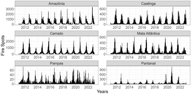
Wildfires are among the most common natural disasters in many world regions and actively impact life quality. These events have become frequent due to climate change, other local policies, and human behavior. Fire spots are areas where the temperature is significantly higher than in the surrounding areas and are often used to identify wildfires. This study considers the historical data with the geographical locations of all the "fire spots" detected by the reference satellites covering the Brazilian territory between January 2011 and December 2022, comprising more than 2.2 million fire spots. This data was modeled with a spatio-temporal generalized linear mixed model for areal unit data, whose inferences about its parameters are made in a Bayesian framework and use meteorological variables (precipitation, air temperature, humidity, and wind speed) and a human variable (land-use transition and occupation) as covariates. The meteorological variables humidity and air temperature showed the most significant impact on the number of fire spots for each of the six Brazilian biomes.
野火是世界许多地区最常见的自然灾害之一,对生活质量有直接影响。由于气候变化、其他地方政策和人类行为,这些事件变得频繁发生。火点是温度明显高于周边地区的区域,常被用于识别野火。本研究考虑了2011年1月至2022年12月期间覆盖巴西领土的参考卫星探测到的所有“火点”的地理位置的历史数据,包括超过220万个火点。该数据采用时空广义线性混合模型对区域单元数据进行建模,其参数推断是在贝叶斯框架下进行的,并使用气象变量(降水量、气温、湿度和风速)和一个人为变量(土地利用转变和占用)作为协变量。气象变量湿度和气温对巴西六个生物群落中每个群落的火点数量影响最为显著。