Prakash Nayak Prathiksha, Pai B Jagadeesha, Govindan Sreejith
Department of Civil Engineering, Manipal Institute of Technology, Manipal Academy of Higher Education, Manipal, 576104, India.
Division of Microbiology, Department of Basic Medical Sciences, Manipal Academy of Higher Education, Manipal, 576104, India.
Trop Med Health. 2025 Aug 4;53(1):102. doi: 10.1186/s41182-025-00783-9.
Vector-borne diseases caused by Aedes mosquitoes remain a major public health concern across tropical and subtropical regions. Geographic Information Systems (GIS) have become integral in surveillance by enabling spatial analysis, risk mapping, and predictive modelling. This scoping review explores how GIS has been applied in surveillance studies and identifies its potential applications, key variables, modelling approaches, and challenges.
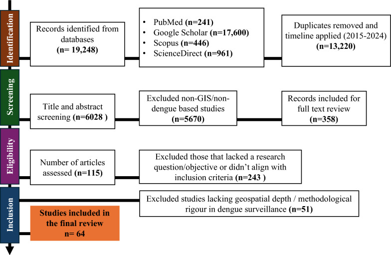
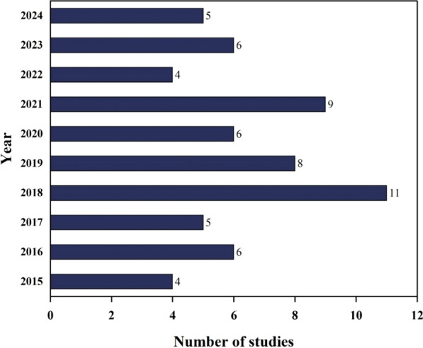
This scoping review was conducted following PRISMA-ScR guidelines and was structured using a search strategy to identify relevant peer-reviewed articles published between 2015 and 2024 across databases like PubMed, Scopus, ScienceDirect, and Google Scholar. A total of 64 studies were selected and charted based on geographic focus, GIS applications, modelling techniques, spatial methods, and key variables.
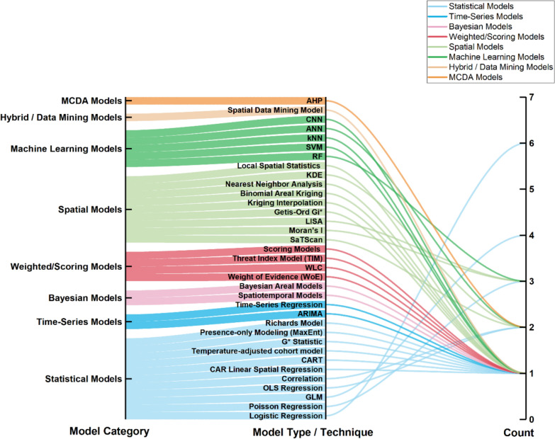
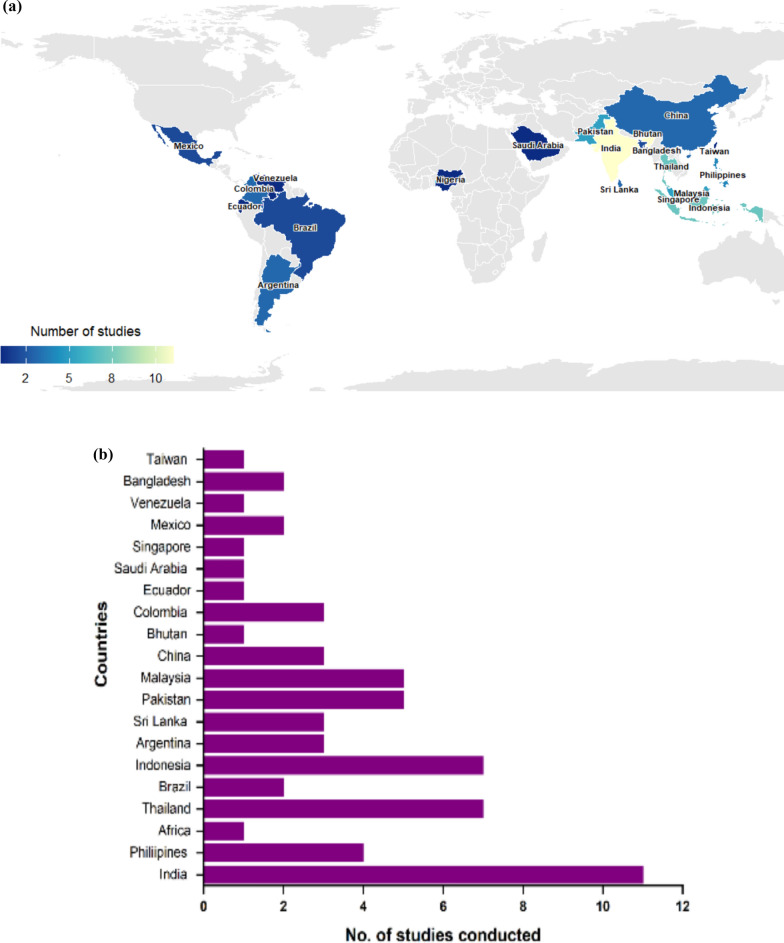
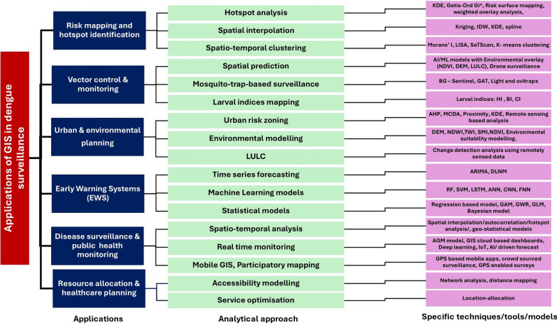
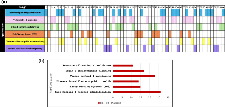
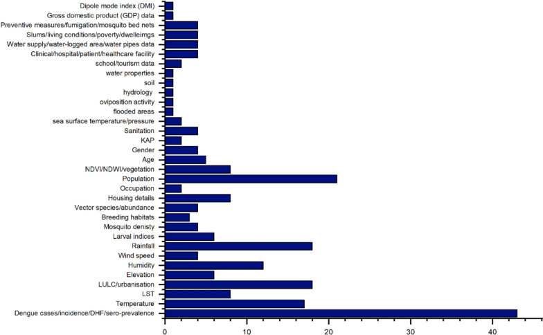
A notable concentration of studies was found in South and Southeast Asia, reflecting the high disease burden and research activity in these regions. ArcGIS and QGIS were the most frequently used platforms in dengue surveillance around the globe. Risk mapping and hotspot detection were the most frequent targeted applications (n = 26), followed by vector control and monitoring (n = 23). Environmental and climatic variables were commonly analysed, including temperature, rainfall, humidity, and Normalised Difference Vegetation Index. Common analytical methods included regression-based spatial models and, increasingly, machine learning techniques along with GIS. Emerging trends include integrating machine learning models, remote sensing data, and mobile GIS for real-time monitoring and early warning systems.
GIS has evolved from a mapping tool into a multidimensional decision-support system in disease surveillance. Its integration with environmental, climatic, and demographic data enables proactive outbreak management and targeted interventions. Future research should leverage Artificial Intelligence, machine learning, the Internet of Things, participatory GIS, and interdisciplinary data to enhance surveillance prediction and public health response. Strengthening collaborative data-sharing frameworks and incorporating machine-learning approaches could further improve the effectiveness of GIS-driven surveillance programs.
由伊蚊传播的疾病仍然是热带和亚热带地区主要的公共卫生问题。地理信息系统(GIS)通过实现空间分析、风险绘图和预测建模,已成为监测工作中不可或缺的一部分。本综述探讨了GIS在监测研究中的应用方式,并确定其潜在应用、关键变量、建模方法和挑战。
本综述遵循PRISMA-ScR指南进行,采用搜索策略来识别2015年至2024年期间在PubMed、Scopus、ScienceDirect和谷歌学术等数据库中发表的相关同行评审文章。共筛选出64项研究,并根据地理重点、GIS应用、建模技术、空间方法和关键变量进行梳理。
研究主要集中在南亚和东南亚,这反映了这些地区的高疾病负担和研究活动。ArcGIS和QGIS是全球登革热监测中最常用的平台。风险绘图和热点检测是最常见的目标应用(n = 26),其次是病媒控制和监测(n = 23)。通常会分析环境和气候变量,包括温度、降雨量、湿度和归一化植被指数。常见的分析方法包括基于回归的空间模型,以及越来越多的与GIS结合的机器学习技术。新趋势包括整合机器学习模型、遥感数据和移动GIS,以建立实时监测和预警系统。
GIS已从一种绘图工具演变为疾病监测中的多维决策支持系统。它与环境、气候和人口数据的整合能够实现主动的疫情管理和有针对性的干预措施。未来的研究应利用人工智能、机器学习、物联网、参与式GIS和跨学科数据,以加强监测预测和公共卫生应对。加强协作数据共享框架并纳入机器学习方法,可进一步提高GIS驱动的监测项目的有效性。