Ruiz Marilyn O, Walker Edward D, Foster Erik S, Haramis Linn D, Kitron Uriel D
Department of Pathobiology, University of Illinois, 2001 South Lincoln Ave, Urbana, IL, USA.
Int J Health Geogr. 2007 Mar 12;6:10. doi: 10.1186/1476-072X-6-10.
West Nile virus infection in humans in urban areas of the Midwestern United States has exhibited strong spatial clustering during epidemic years. We derived urban landscape classes from the physical and socio-economic factors hypothesized to be associated with West Nile Virus (WNV) transmission and compared those to human cases of illness in 2002 in Chicago and Detroit. The objectives were to improve understanding of human exposure to virus-infected mosquitoes in the urban context, and to assess the degree to which environmental factors found to be important in Chicago were also found in Detroit.
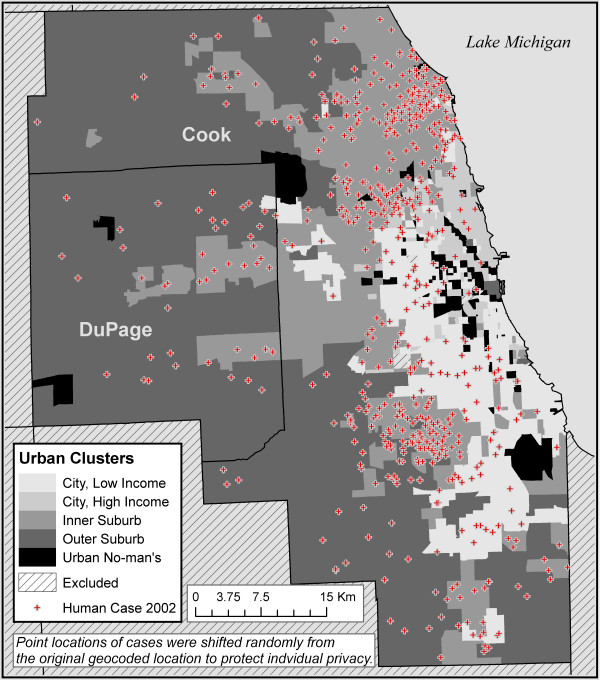
Five urban classes that partitioned the urban space were developed for each city region. The classes had many similarities in the two settings. In both regions, the WNV case rate was considerably higher in the urban class associated with the Inner Suburbs, where 1940-1960 era housing dominates, vegetation cover is moderate, and population density is moderate. The land cover mapping approach played an important role in the successful and consistent classification of the urban areas.
The analysis demonstrates how urban form and past land use decisions can influence transmission of a vector-borne virus. In addition, the results are helpful to develop hypotheses regarding urban landscape features and WNV transmission, they provide a structured method to stratify the urban areas to locate representative field study sites specifically for WNV, and this analysis contributes to the question of how the urban environment affects human health.
在美国中西部城市地区,人类感染西尼罗河病毒在流行年份呈现出强烈的空间聚集性。我们从假设与西尼罗河病毒(WNV)传播相关的自然和社会经济因素中得出城市景观类别,并将其与2002年芝加哥和底特律的人类病例进行比较。目的是增进对城市环境中人类接触病毒感染蚊子情况的了解,并评估在芝加哥发现的重要环境因素在底特律是否也存在。
为每个城市区域划分出五个城市类别,这些类别在两种环境中有许多相似之处。在两个区域中,与内郊区相关的城市类别中西尼罗河病毒病例率都相当高,内郊区以1940 - 1960年代的房屋为主,植被覆盖适中,人口密度适中。土地覆盖制图方法在城市区域的成功且一致的分类中发挥了重要作用。
分析表明城市形态和过去的土地利用决策如何影响媒介传播病毒的传播。此外,研究结果有助于提出关于城市景观特征与西尼罗河病毒传播的假设,提供一种结构化方法对城市区域进行分层,以确定专门针对西尼罗河病毒的代表性实地研究地点,并且该分析有助于解答城市环境如何影响人类健康这一问题。