International Center for Diarrhoeal Disease Research Bangladesh, 68 Shaheed Tajuddin Ahmed Sharani, Mohakhali, Dhaka 1212, Bangladesh.
Malar J. 2010 May 9;9:120. doi: 10.1186/1475-2875-9-120.
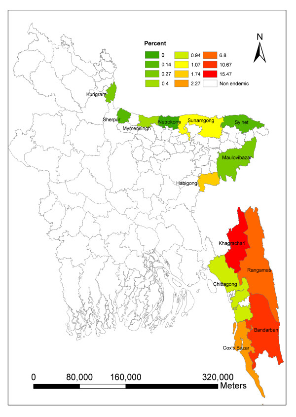
Malaria is a major public health burden in Southeastern Bangladesh, particularly in the Chittagong Hill Tracts region. Malaria is endemic in 13 districts of Bangladesh and the highest prevalence occurs in Khagrachari (15.47%).
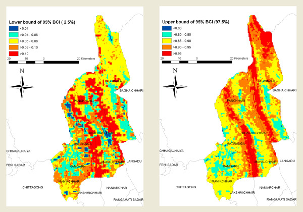
A risk map was developed and geographic risk factors identified using a Bayesian approach. The Bayesian geostatistical model was developed from previously identified individual and environmental covariates (p < 0.2; age, different forest types, elevation and economic status) for malaria prevalence using WinBUGS 1.4. Spatial correlation was estimated within a Bayesian framework based on a geostatistical model. The infection status (positives and negatives) was modeled using a Bernoulli distribution. Maps of the posterior distributions of predicted prevalence were developed in geographic information system (GIS).
Predicted high prevalence areas were located along the north-eastern areas, and central part of the study area. Low to moderate prevalence areas were predicted in the southwestern, southeastern and central regions. Individual age and nearness to fragmented forest were associated with malaria prevalence after adjusting the spatial auto-correlation.
A Bayesian analytical approach using multiple enabling technologies (geographic information systems, global positioning systems, and remote sensing) provide a strategy to characterize spatial heterogeneity in malaria risk at a fine scale. Even in the most hyper endemic region of Bangladesh there is substantial spatial heterogeneity in risk. Areas that are predicted to be at high risk, based on the environment but that have not been reached by surveys are identified.
疟疾是孟加拉国东南部,特别是吉大港山区的一个主要公共卫生负担。疟疾在孟加拉国的 13 个区流行,在 Khagrachari 区(15.47%)的发病率最高。
使用贝叶斯方法绘制了风险图,并确定了地理风险因素。贝叶斯地质统计学模型是根据以前确定的个人和环境协变量(p<0.2;年龄、不同的森林类型、海拔和经济状况)为疟疾发病率开发的(WinBUGS 1.4)。在贝叶斯框架内,根据地质统计学模型,估计了空间相关性。感染状态(阳性和阴性)用伯努利分布进行建模。在地理信息系统(GIS)中开发了预测流行率的后验分布地图。
预测的高流行地区位于研究区域的东北部和中部。预测西南部、东南部和中部地区的流行率较低至中等。在调整空间自相关后,个体年龄和靠近碎片化森林与疟疾流行率有关。
使用多种使能技术(地理信息系统、全球定位系统和遥感)的贝叶斯分析方法提供了一种策略,可以在精细尺度上描述疟疾风险的空间异质性。即使在孟加拉国发病率最高的地区,风险也存在很大的空间异质性。根据环境预测的高风险地区,但尚未被调查发现。