Wieczorek William F, Delmerico Alan M
Comput Stat. 2009;1(2):167-186. doi: 10.1002/wics.21.
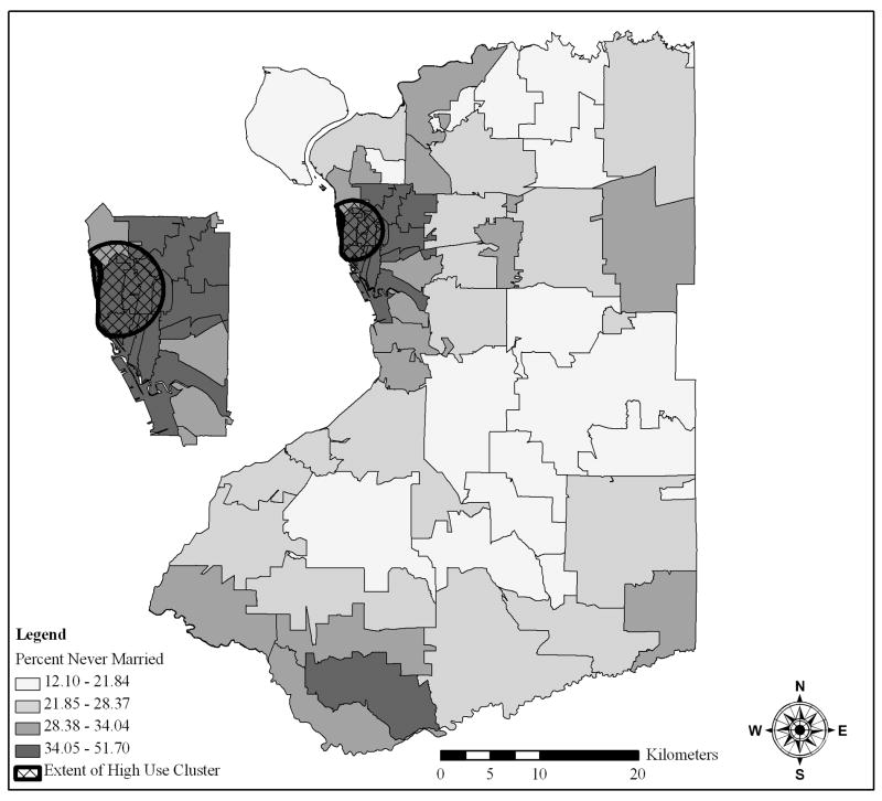
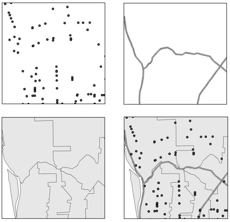
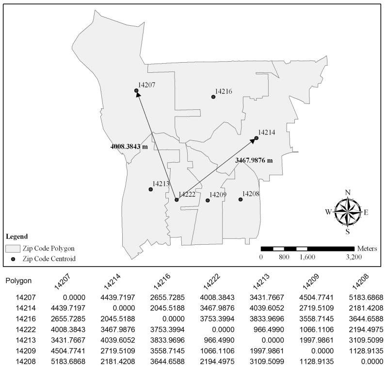
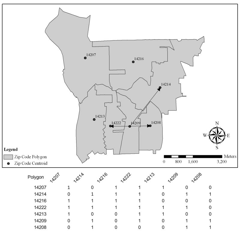
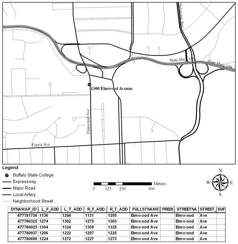
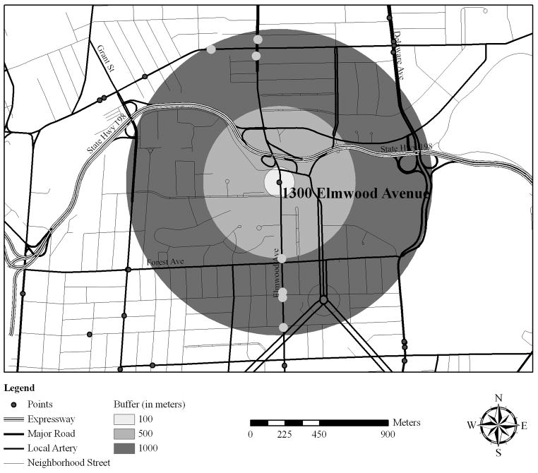
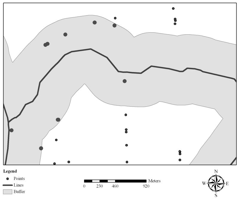
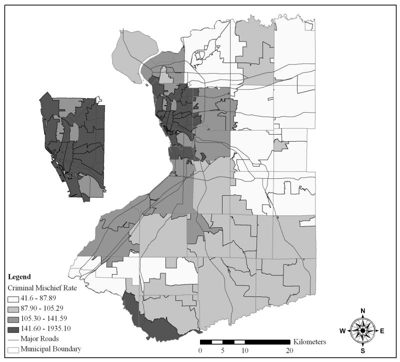
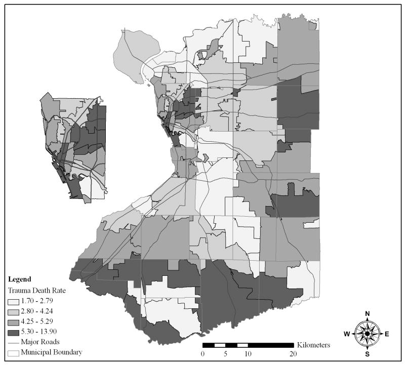
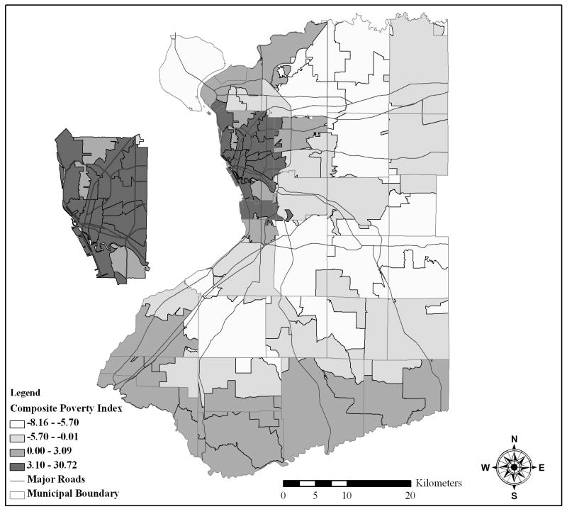
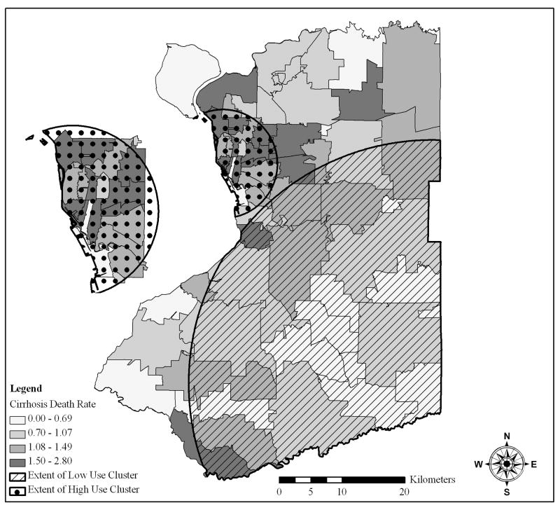
This chapter presents an overview of the development, capabilities, and utilization of geographic information systems (GIS). There are nearly an unlimited number of applications that are relevant to GIS because virtually all human interactions, natural and man-made features, resources, and populations have a geographic component. Everything happens somewhere and the location often has a role that affects what occurs. This role is often called spatial dependence or spatial autocorrelation, which exists when a phenomenon is not randomly geographically distributed. GIS has a number of key capabilities that are needed to conduct a spatial analysis to assess this spatial dependence. This chapter presents these capabilities (e.g., georeferencing, adjacency/distance measures, overlays) and provides a case study to illustrate how GIS can be used for both research and planning. Although GIS has developed into a relatively mature application for basic functions, development is needed to more seamlessly integrate spatial statistics and models.The issue of location, especially the geography of human activities, interactions between humanity and nature, and the distribution and location of natural resources and features, is one of the most basic elements of scientific inquiry. Conceptualizations and physical maps of geographic space have existed since the beginning of time because all human activity takes place in a geographic context. Representing objects in space, basically where things are located, is a critical aspect of the natural, social, and applied sciences. Throughout history there have been many methods of characterizing geographic space, especially maps created by artists, mariners, and others eventually leading to the development of the field of cartography. It is no surprise that the digital age has launched a major effort to utilize geographic data, but not just as maps. A geographic information system (GIS) facilitates the collection, analysis, and reporting of spatial data and related phenomena. The capabilities of GIS are much more than just mapping, although map production is one of the most utilized features. GIS applications are relevant in a tremendous number of areas ranging from basic geographic inventories to simulation models.This chapter presents a general overview of geographic information system topics. The purpose is to provide the reader with a basic understanding of a GIS, the types of data that are needed, the basic functionality of these systems, the role of spatial analysis, and an example in the form of a case study. The chapter is designed to provide advanced students and experts outside of the field of GIS sufficient information to begin to utilize GIS and spatial analytic concepts, but it is not designed to be the sole basis for becoming a GIS expert. There is a tremendous level of sophistication related to the digital cartographic databases and manipulation of those databases underlying the display and use of GIS that is more appropriately a part of geographic information science (i.e., basic research issues associated with geographic data including technical as well as theoretical aspects such as the impact on society [1]) rather than being relevant to this chapter. The utilization of GIS for conducting spatial analysis is the guiding theme for the chapter.
本章概述了地理信息系统(GIS)的发展、功能及应用。与GIS相关的应用几乎数不胜数,因为几乎所有人类活动、自然和人造特征、资源及人口都有地理成分。一切事情都发生在某个地方,而位置往往会对所发生的事情产生影响。这种影响通常被称为空间依赖性或空间自相关性,当一种现象在地理上并非随机分布时就会存在。进行空间分析以评估这种空间依赖性需要GIS具备多项关键功能。本章介绍了这些功能(如地理配准、邻接/距离测量、叠加分析),并提供了一个案例研究,以说明GIS如何用于研究和规划。尽管GIS在基本功能方面已发展成为一种相对成熟的应用,但仍需要进一步发展,以便更无缝地整合空间统计和模型。
位置问题,尤其是人类活动的地理分布、人与自然的相互作用以及自然资源和地物的分布与位置,是科学探究最基本的要素之一。自人类伊始,就存在着对地理空间的概念化认知和实体地图,因为所有人类活动都发生在地理环境之中。在空间中表示物体,即事物所处的位置,是自然科学、社会科学和应用科学的一个关键方面。纵观历史,有许多描述地理空间的方法,尤其是艺术家、水手等绘制的地图,这些最终推动了制图学领域的发展。数字时代大力利用地理数据也就不足为奇了,但不仅仅是将其用作地图。地理信息系统(GIS)有助于收集、分析和报告空间数据及相关现象。GIS的功能远不止于制图,尽管地图制作是其最常用的功能之一。GIS应用在从基础地理清查到模拟模型等众多领域都有相关性。
本章对地理信息系统的主题进行了总体概述。目的是让读者对GIS有基本的了解,包括所需的数据类型、这些系统的基本功能、空间分析的作用以及一个案例形式的示例。本章旨在为GIS领域之外的高年级学生和专家提供足够的信息,以便他们开始使用GIS和空间分析概念,但并非旨在成为GIS专家的唯一依据。与数字制图数据库以及在GIS显示和使用背后对这些数据库的操作相关的复杂程度极高,这更适合作为地理信息科学的一部分(即与地理数据相关的基础研究问题,包括技术以及理论方面,如对社会的影响[1]),而与本章内容无关。利用GIS进行空间分析是本章的指导主题。