Department of Environmental Science, Policy and Management, University of California, Berkeley, Berkeley, California, United States of America.
PLoS One. 2012;7(2):e28969. doi: 10.1371/journal.pone.0028969. Epub 2012 Feb 16.
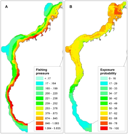
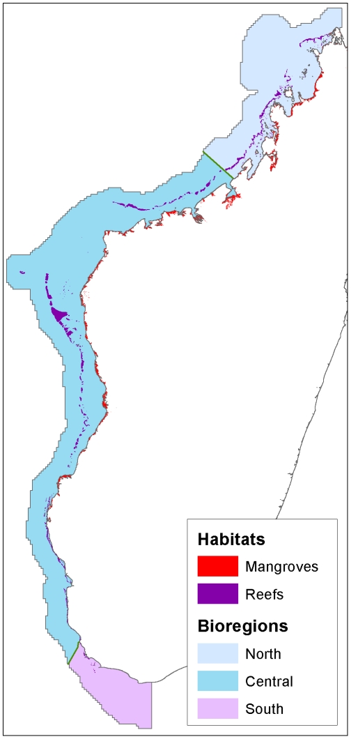
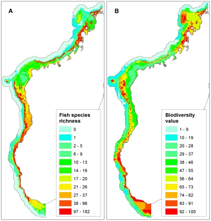
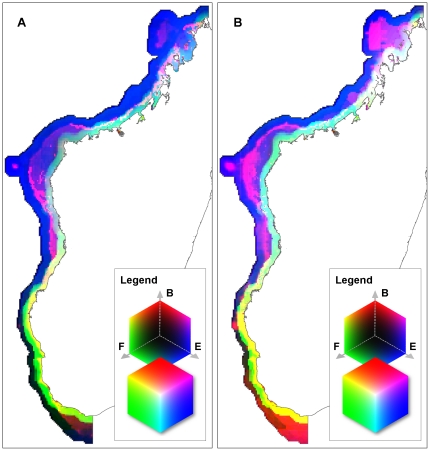
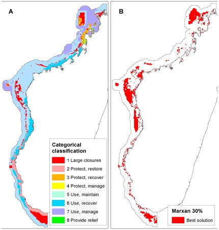
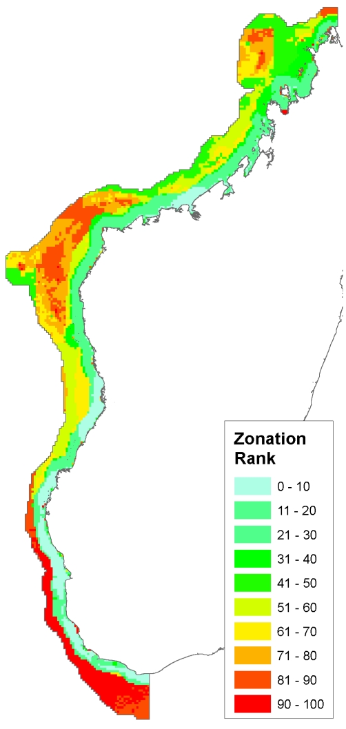
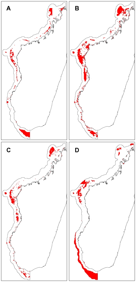
The Government of Madagascar plans to increase marine protected area coverage by over one million hectares. To assist this process, we compare four methods for marine spatial planning of Madagascar's west coast. Input data for each method was drawn from the same variables: fishing pressure, exposure to climate change, and biodiversity (habitats, species distributions, biological richness, and biodiversity value). The first method compares visual color classifications of primary variables, the second uses binary combinations of these variables to produce a categorical classification of management actions, the third is a target-based optimization using Marxan, and the fourth is conservation ranking with Zonation. We present results from each method, and compare the latter three approaches for spatial coverage, biodiversity representation, fishing cost and persistence probability. All results included large areas in the north, central, and southern parts of western Madagascar. Achieving 30% representation targets with Marxan required twice the fish catch loss than the categorical method. The categorical classification and Zonation do not consider targets for conservation features. However, when we reduced Marxan targets to 16.3%, matching the representation level of the "strict protection" class of the categorical result, the methods show similar catch losses. The management category portfolio has complete coverage, and presents several management recommendations including strict protection. Zonation produces rapid conservation rankings across large, diverse datasets. Marxan is useful for identifying strict protected areas that meet representation targets, and minimize exposure probabilities for conservation features at low economic cost. We show that methods based on Zonation and a simple combination of variables can produce results comparable to Marxan for species representation and catch losses, demonstrating the value of comparing alternative approaches during initial stages of the planning process. Choosing an appropriate approach ultimately depends on scientific and political factors including representation targets, likelihood of adoption, and persistence goals.
马达加斯加政府计划将海洋保护区的覆盖面积增加超过 100 万公顷。为了协助这一进程,我们比较了四种马达加斯加西海岸海洋空间规划方法。每种方法的输入数据均来自相同的变量:捕捞压力、气候变化暴露程度和生物多样性(生境、物种分布、生物丰富度和生物多样性价值)。第一种方法比较了主要变量的视觉颜色分类,第二种方法使用这些变量的二进制组合生成管理措施的分类,第三种方法是基于 Marxan 的目标优化,第四种方法是基于 Zonation 的保护排序。我们展示了每种方法的结果,并比较了后三种方法在空间覆盖范围、生物多样性代表性、捕捞成本和持久性概率方面的表现。所有结果都包括马达加斯加西部北部、中部和南部的大片区域。使用 Marxan 实现 30%的代表性目标所需的渔获损失是分类方法的两倍。分类方法和 Zonation 都不考虑保护特征的目标。但是,当我们将 Marxan 的目标减少到 16.3%,与分类结果的“严格保护”类别的代表性水平相匹配时,这些方法的渔获损失相似。管理类别投资组合具有全面的覆盖范围,并提出了包括严格保护在内的多项管理建议。Zonation 可在大型多样数据集上快速进行保护排名。Marxan 可用于确定符合代表性目标的严格保护区,并以低经济成本最小化保护特征的暴露概率。我们表明,基于 Zonation 和简单变量组合的方法可以在物种代表性和渔获损失方面产生与 Marxan 相当的结果,这表明在规划过程的初始阶段比较替代方法具有价值。选择适当的方法最终取决于科学和政治因素,包括代表性目标、采用的可能性和持久性目标。