• 文献检索
  • 文档翻译
  • 深度研究
  • 学术资讯
  • Suppr Zotero 插件Zotero 插件
  • 邀请有礼
  • 套餐&价格
  • 历史记录
应用&插件
Suppr Zotero 插件Zotero 插件浏览器插件Mac 客户端Windows 客户端微信小程序
定价
高级版会员购买积分包购买API积分包
服务
文献检索文档翻译深度研究API 文档MCP 服务
关于我们
关于 Suppr公司介绍联系我们用户协议隐私条款
关注我们

Suppr 超能文献

核心技术专利:CN118964589B侵权必究
粤ICP备2023148730 号-1Suppr @ 2026

文献检索

告别复杂PubMed语法,用中文像聊天一样搜索,搜遍4000万医学文献。AI智能推荐,让科研检索更轻松。

立即免费搜索

文件翻译

保留排版,准确专业,支持PDF/Word/PPT等文件格式,支持 12+语言互译。

免费翻译文档

深度研究

AI帮你快速写综述,25分钟生成高质量综述,智能提取关键信息,辅助科研写作。

立即免费体验

GenGIS 2:传统和遗传生物多样性的地理空间分析,具有新的梯度算法和可扩展的插件框架。

GenGIS 2: geospatial analysis of traditional and genetic biodiversity, with new gradient algorithms and an extensible plugin framework.

机构信息

Faculty of Computer Science, Dalhousie University, Halifax, Nova Scotia, Canada.

出版信息

PLoS One. 2013 Jul 29;8(7):e69885. doi: 10.1371/journal.pone.0069885. Print 2013.

DOI:10.1371/journal.pone.0069885
PMID:23922841
原文链接:https://pmc.ncbi.nlm.nih.gov/articles/PMC3726740/
Abstract

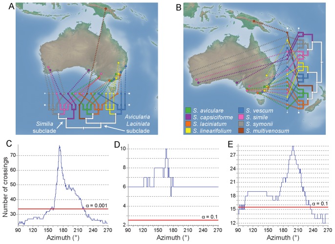
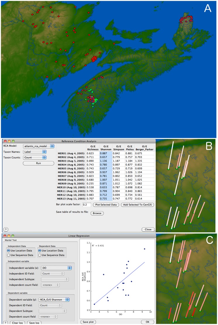
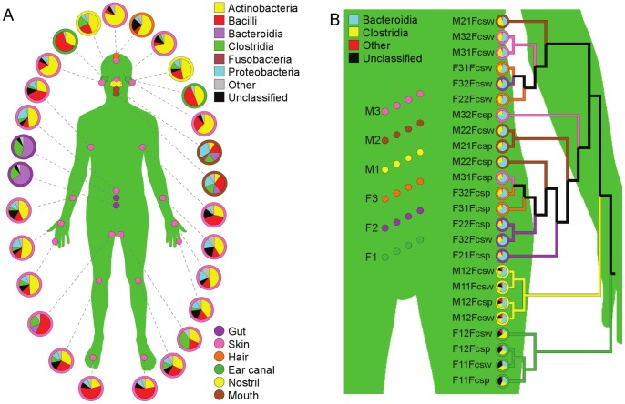
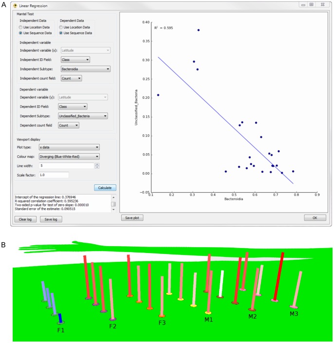
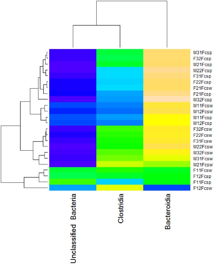
GenGIS is free and open source software designed to integrate biodiversity data with a digital map and information about geography and habitat. While originally developed with microbial community analyses and phylogeography in mind, GenGIS has been applied to a wide range of datasets. A key feature of GenGIS is the ability to test geographic axes that can correspond to routes of migration or gradients that influence community similarity. Here we introduce GenGIS version 2, which extends the linear gradient tests introduced in the first version to allow comprehensive testing of all possible linear geographic axes. GenGIS v2 also includes a new plugin framework that supports the development and use of graphically driven analysis packages: initial plugins include implementations of linear regression and the Mantel test, calculations of alpha-diversity (e.g., Shannon Index) for all samples, and geographic visualizations of dissimilarity matrices. We have also implemented a recently published method for biomonitoring reference condition analysis (RCA), which compares observed species richness and diversity to predicted values to determine whether a given site has been impacted. The newest version of GenGIS supports vector data in addition to raster files. We demonstrate the new features of GenGIS by performing a full gradient analysis of an Australian kangaroo apple data set, by using plugins and embedded statistical commands to analyze human microbiome sample data, and by applying RCA to a set of samples from Atlantic Canada. GenGIS release versions, tutorials and documentation are freely available at http://kiwi.cs.dal.ca/GenGIS, and source code is available at https://github.com/beiko-lab/gengis.

摘要

GenGIS 是一款免费的开源软件,旨在将生物多样性数据与数字地图以及地理和生境信息集成在一起。虽然最初是为微生物群落分析和系统地理学开发的,但 GenGIS 已经应用于广泛的数据集。GenGIS 的一个关键特点是能够测试与迁移路线或影响群落相似性的梯度相对应的地理轴。在这里,我们介绍 GenGIS 版本 2,它扩展了在第一个版本中引入的线性梯度测试,以允许对所有可能的线性地理轴进行全面测试。GenGIS v2 还包括一个新的插件框架,支持图形驱动的分析包的开发和使用:初始插件包括线性回归和 Mantel 测试的实现、所有样本的 alpha 多样性(例如 Shannon 指数)的计算,以及不相似性矩阵的地理可视化。我们还实现了一种用于生物监测参考条件分析 (RCA) 的新方法,该方法将观察到的物种丰富度和多样性与预测值进行比较,以确定给定地点是否受到影响。最新版本的 GenGIS 除了栅格文件外还支持矢量数据。我们通过对澳大利亚袋鼠苹果数据集进行完整的梯度分析、使用插件和嵌入式统计命令来分析人类微生物组样本数据以及对来自加拿大大西洋的一组样本应用 RCA 来演示 GenGIS 的新功能。GenGIS 的发行版本、教程和文档可在 http://kiwi.cs.dal.ca/GenGIS 上免费获得,源代码可在 https://github.com/beiko-lab/gengis 上获得。

https://cdn.ncbi.nlm.nih.gov/pmc/blobs/4183/3726740/207435feb30b/pone.0069885.g005.jpg
https://cdn.ncbi.nlm.nih.gov/pmc/blobs/4183/3726740/b977fd3bef59/pone.0069885.g001.jpg
https://cdn.ncbi.nlm.nih.gov/pmc/blobs/4183/3726740/921e5f35f172/pone.0069885.g002.jpg
https://cdn.ncbi.nlm.nih.gov/pmc/blobs/4183/3726740/a0800b149ac4/pone.0069885.g003.jpg
https://cdn.ncbi.nlm.nih.gov/pmc/blobs/4183/3726740/f071431551fc/pone.0069885.g004.jpg
https://cdn.ncbi.nlm.nih.gov/pmc/blobs/4183/3726740/207435feb30b/pone.0069885.g005.jpg

相似文献

1
GenGIS 2: geospatial analysis of traditional and genetic biodiversity, with new gradient algorithms and an extensible plugin framework.GenGIS 2:传统和遗传生物多样性的地理空间分析,具有新的梯度算法和可扩展的插件框架。
PLoS One. 2013 Jul 29;8(7):e69885. doi: 10.1371/journal.pone.0069885. Print 2013.
2
GenGIS: A geospatial information system for genomic data.GenGIS:用于基因组数据的地理空间信息系统。
Genome Res. 2009 Oct;19(10):1896-904. doi: 10.1101/gr.095612.109. Epub 2009 Jul 27.
3
Folic acid supplementation and malaria susceptibility and severity among people taking antifolate antimalarial drugs in endemic areas.在流行地区,服用抗叶酸抗疟药物的人群中,叶酸补充剂与疟疾易感性和严重程度的关系。
Cochrane Database Syst Rev. 2022 Feb 1;2(2022):CD014217. doi: 10.1002/14651858.CD014217.
4
NeuroPycon: An open-source python toolbox for fast multi-modal and reproducible brain connectivity pipelines.NeuroPycon:一个开源的 Python 工具包,用于快速进行多模态和可重复的脑连接管道。
Neuroimage. 2020 Oct 1;219:117020. doi: 10.1016/j.neuroimage.2020.117020. Epub 2020 Jun 6.
5
SBcoyote: An Extensible Python-Based Reaction Editor and Viewer.SBcoyote:一个基于Python的可扩展反应编辑器和查看器。
ArXiv. 2023 Aug 14:arXiv:2302.09151v2.
6
SBcoyote: An extensible Python-based reaction editor and viewer.SBcoyote:一个基于 Python 的可扩展的反应编辑器和查看器。
Biosystems. 2023 Oct;232:105001. doi: 10.1016/j.biosystems.2023.105001. Epub 2023 Aug 16.
7
A plugin for the Ensembl Variant Effect Predictor that uses MaxEntScan to predict variant spliceogenicity.一个 Ensembl Variant Effect Predictor 的插件,它使用 MaxEntScan 来预测变异的剪接体发生。
Bioinformatics. 2019 Jul 1;35(13):2315-2317. doi: 10.1093/bioinformatics/bty960.
8
Hydroids (Cnidaria, Hydrozoa) from Mauritanian Coral Mounds.来自毛里塔尼亚珊瑚丘的水螅虫纲动物(刺胞动物门,水螅虫纲)。
Zootaxa. 2020 Nov 16;4878(3):zootaxa.4878.3.2. doi: 10.11646/zootaxa.4878.3.2.
9
Diversity of Eastern North American ant communities along environmental gradients.沿环境梯度的北美东部蚂蚁群落的多样性。
PLoS One. 2013 Jul 12;8(7):e67973. doi: 10.1371/journal.pone.0067973. Print 2013.
10
The geospatial data quality REST API for primary biodiversity data.用于主要生物多样性数据的地理空间数据质量REST应用程序编程接口。
Bioinformatics. 2016 Jun 1;32(11):1755-7. doi: 10.1093/bioinformatics/btw057. Epub 2016 Feb 1.

引用本文的文献

1
Redefining the Geographic Distribution of Two Cryptic (Hymenoptera: Halictidae) Species in the Eastern United States.重新界定美国东部两种隐存(膜翅目:隧蜂科)物种的地理分布范围。
Ecol Evol. 2025 Jun 20;15(6):e71570. doi: 10.1002/ece3.71570. eCollection 2025 Jun.
2
The More the Better: Genetic Monitoring of (Lamarck, 1816) Experimental Restockings in Sardinia (Western Mediterranean Sea).越多越好:对撒丁岛(地中海西部)(拉马克,1816年)实验性放流的遗传监测
Animals (Basel). 2025 Feb 14;15(4):554. doi: 10.3390/ani15040554.
3
Ice cage: new records and cryptic, isolated lineages in wingless snow flies (Diptera, Limoniidae: Chionea spp.) in German lower mountain ranges.

本文引用的文献

1
The Supramap project: linking pathogen genomes with geography to fight emergent infectious diseases.超级图谱项目:将病原体基因组与地理位置相联系以对抗新发传染病
Cladistics. 2011 Feb;27(1):61-66. doi: 10.1111/j.1096-0031.2010.00314.x. Epub 2011 Jan 4.
2
Towards generalised reference condition models for environmental assessment: a case study on rivers in Atlantic Canada.迈向通用参照条件模型的环境评估:以加拿大大西洋地区河流为例。
Environ Monit Assess. 2013 Aug;185(8):6247-59. doi: 10.1007/s10661-012-3021-2. Epub 2012 Dec 19.
3
Biomonitoring 2.0: a new paradigm in ecosystem assessment made possible by next-generation DNA sequencing.
冰笼:德国低山山脉无翅雪蝇(双翅目,石蝇科:Chionea 种)中的新记录和隐生、孤立谱系。
Naturwissenschaften. 2024 Mar 13;111(2):15. doi: 10.1007/s00114-024-01900-0.
4
Phylogeography and ecological niche modeling implicate multiple microrefugia of Swertia tetraptera during quaternary glaciations.系统发生地理学和生态位建模提示,川西獐牙菜在第四纪冰期中存在多个微避难所。
BMC Plant Biol. 2023 Sep 26;23(1):450. doi: 10.1186/s12870-023-04471-w.
5
Incidence of Coffee Leaf Rust in Vietnam, Possible Original Sources and Subsequent Pathways of Migration.越南咖啡叶锈病的发病率、可能的原始来源及后续传播途径
Front Plant Sci. 2022 Apr 5;13:872877. doi: 10.3389/fpls.2022.872877. eCollection 2022.
6
Molecular species delimitation of shrub frogs of the genus Pseudophilautus (Anura, Rhacophoridae).分子种系发生学界定 Pseudophilautus(无尾目,树蛙科)属灌木蛙。
PLoS One. 2021 Oct 19;16(10):e0258594. doi: 10.1371/journal.pone.0258594. eCollection 2021.
7
Phylogeography of Baryancistrus xanthellus (Siluriformes: Loricariidae), a rheophilic catfish endemic to the Xingu River basin in eastern Amazonia.东亚马孙地区欣古河流域特有洄游性鲶鱼巴氏南美脂鲤的系统地理学研究
PLoS One. 2021 Aug 27;16(8):e0256677. doi: 10.1371/journal.pone.0256677. eCollection 2021.
8
Evolution in Sinocyclocheilus cavefish is marked by rate shifts, reversals, and origin of novel traits.洞穴鱼 Sinocyclocheilus 的进化具有速率转变、逆转和新特征起源的特点。
BMC Ecol Evol. 2021 Mar 17;21(1):45. doi: 10.1186/s12862-021-01776-y.
9
Phylogenomics of reveals a new lineage and a complex evolutionary history.系统发生基因组学揭示了一个新谱系和一个复杂的进化历史。
Microb Genom. 2021 Feb;7(2). doi: 10.1099/mgen.0.000477.
10
Wine Terroir and the Soil Bacteria: An Amplicon Sequencing-Based Assessment of the Barossa Valley and Its Sub-Regions.葡萄酒风土与土壤细菌:基于扩增子测序对巴罗萨谷及其子区域的评估
Front Microbiol. 2021 Jan 7;11:597944. doi: 10.3389/fmicb.2020.597944. eCollection 2020.
生物监测 2.0:下一代 DNA 测序带来的生态系统评估新模式。
Mol Ecol. 2012 Apr;21(8):2039-44. doi: 10.1111/j.1365-294x.2012.05519.x.
4
Cultural phylogenetics of the Tupi language family in lowland South America.南美洲低地地区图皮语系的文化系统发生学。
PLoS One. 2012;7(4):e35025. doi: 10.1371/journal.pone.0035025. Epub 2012 Apr 10.
5
Integrating biodiversity distribution knowledge: toward a global map of life.整合生物多样性分布知识:绘制全球生命地图。
Trends Ecol Evol. 2012 Mar;27(3):151-9. doi: 10.1016/j.tree.2011.09.007. Epub 2011 Oct 21.
6
SPREAD: spatial phylogenetic reconstruction of evolutionary dynamics.SPREAD:进化动态的空间系统发生重建。
Bioinformatics. 2011 Oct 15;27(20):2910-2. doi: 10.1093/bioinformatics/btr481. Epub 2011 Sep 11.
7
Genetic diversity and population structure of the secondary symbiont of tsetse flies, Sodalis glossinidius, in sleeping sickness foci in Cameroon.冈比亚锥虫的次级共生菌——索达利丝菌在喀麦隆昏睡病疫区的遗传多样性和种群结构。
PLoS Negl Trop Dis. 2011 Aug;5(8):e1281. doi: 10.1371/journal.pntd.0001281. Epub 2011 Aug 23.
8
geophylobuilder 1.0: an arcgis extension for creating 'geophylogenies'.地质 phylobuilder 1.0:一个用于创建“地质系统发生树”的 arcgis 扩展。
Mol Ecol Resour. 2008 Jan;8(1):88-91. doi: 10.1111/j.1471-8286.2007.01925.x.
9
Environmental barcoding: a next-generation sequencing approach for biomonitoring applications using river benthos.环境条码:利用河流底栖生物的下一代测序方法进行生物监测应用
PLoS One. 2011 Apr 13;6(4):e17497. doi: 10.1371/journal.pone.0017497.
10
PhyloGeoViz: a web-based program that visualizes genetic data on maps.PhyloGeoViz:一个基于网络的程序,可在地图上可视化遗传数据。
Mol Ecol Resour. 2011 May;11(3):557-61. doi: 10.1111/j.1755-0998.2010.02964.x. Epub 2010 Dec 28.