• 文献检索
  • 文档翻译
  • 深度研究
  • 学术资讯
  • Suppr Zotero 插件Zotero 插件
  • 邀请有礼
  • 套餐&价格
  • 历史记录
应用&插件
Suppr Zotero 插件Zotero 插件浏览器插件Mac 客户端Windows 客户端微信小程序
定价
高级版会员购买积分包购买API积分包
服务
文献检索文档翻译深度研究API 文档MCP 服务
关于我们
关于 Suppr公司介绍联系我们用户协议隐私条款
关注我们

Suppr 超能文献

核心技术专利:CN118964589B侵权必究
粤ICP备2023148730 号-1Suppr @ 2026

文献检索

告别复杂PubMed语法,用中文像聊天一样搜索,搜遍4000万医学文献。AI智能推荐,让科研检索更轻松。

立即免费搜索

文件翻译

保留排版,准确专业,支持PDF/Word/PPT等文件格式,支持 12+语言互译。

免费翻译文档

深度研究

AI帮你快速写综述,25分钟生成高质量综述,智能提取关键信息,辅助科研写作。

立即免费体验

创建用于空气质量建模的本地解析移动源排放输入数据,以支持美国密歇根州底特律的一项暴露研究。

Creating locally-resolved mobile-source emissions inputs for air quality modeling in support of an exposure study in Detroit, Michigan, USA.

作者信息

Snyder Michelle, Arunachalam Saravanan, Isakov Vlad, Talgo Kevin, Naess Brian, Valencia Alejandro, Omary Mohammad, Davis Neil, Cook Rich, Hanna Adel

机构信息

Institute for the Environment, University of North Carolina at Chapel Hill, 100 Europa Drive, Suite 490, Chapel Hill, NC 27517, USA.

National Exposure Research Laboratory, U.S. Environmental Protection Agency, 109 T.W. Alexander Drive, Research Triangle Park, NC 27711, USA.

出版信息

Int J Environ Res Public Health. 2014 Dec 9;11(12):12739-66. doi: 10.3390/ijerph111212739. Print 2014 Dec.

DOI:10.3390/ijerph111212739
PMID:25501000
原文链接:https://pmc.ncbi.nlm.nih.gov/articles/PMC4276644/
Abstract

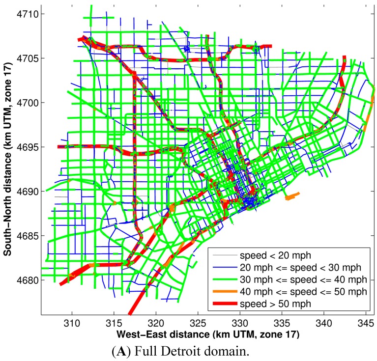
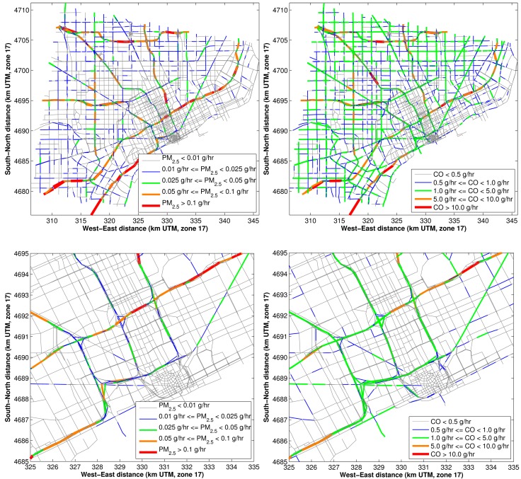
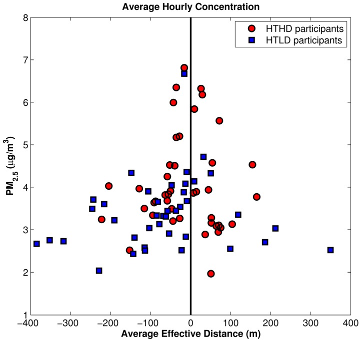
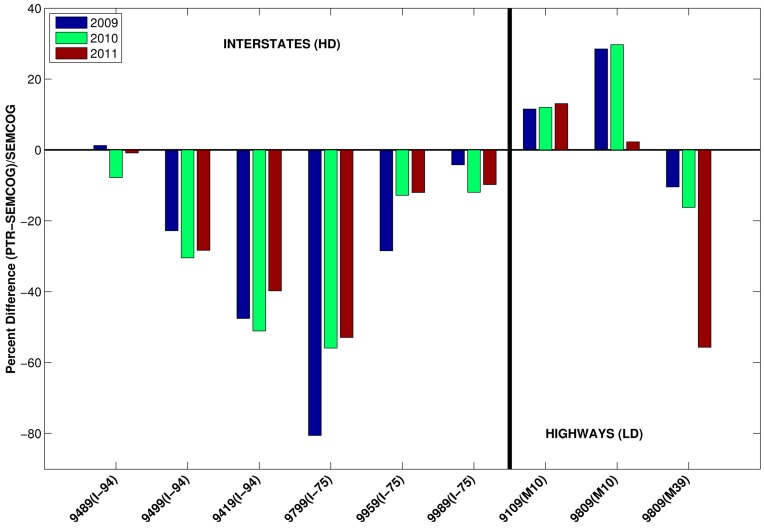
This work describes a methodology for modeling the impact of traffic-generated air pollutants in an urban area. This methodology presented here utilizes road network geometry, traffic volume, temporal allocation factors, fleet mixes, and emission factors to provide critical modeling inputs. These inputs, assembled from a variety of sources, are combined with meteorological inputs to generate link-based emissions for use in dispersion modeling to estimate pollutant concentration levels due to traffic. A case study implementing this methodology for a large health study is presented, including a sensitivity analysis of the modeling results reinforcing the importance of model inputs and identify those having greater relative impact, such as fleet mix. In addition, an example use of local measurements of fleet activity to supplement model inputs is described, and its impacts to the model outputs are discussed. We conclude that with detailed model inputs supported by local traffic measurements and meteorology, it is possible to capture the spatial and temporal patterns needed to accurately estimate exposure from traffic-related pollutants.

摘要

这项工作描述了一种对城市地区交通产生的空气污染物影响进行建模的方法。此处介绍的这种方法利用道路网络几何形状、交通流量、时间分配因子、车队组合和排放因子来提供关键的建模输入。这些从各种来源收集的输入与气象输入相结合,以生成基于路段的排放,用于扩散建模,以估计交通产生的污染物浓度水平。本文介绍了一个将该方法应用于大型健康研究的案例研究,包括对建模结果的敏感性分析,强化了模型输入的重要性,并确定了那些具有更大相对影响的因素,如车队组合。此外,还描述了一个使用车队活动的本地测量值来补充模型输入的示例,并讨论了其对模型输出的影响。我们得出结论,在本地交通测量和气象数据支持的详细模型输入的情况下,有可能捕捉到准确估计与交通相关污染物暴露所需的空间和时间模式。

https://cdn.ncbi.nlm.nih.gov/pmc/blobs/12f9/4276644/e4791eb5dff3/ijerph-11-12739-g015.jpg
https://cdn.ncbi.nlm.nih.gov/pmc/blobs/12f9/4276644/f503eff6695f/ijerph-11-12739-g001a.jpg
https://cdn.ncbi.nlm.nih.gov/pmc/blobs/12f9/4276644/6e672fe820ed/ijerph-11-12739-g002a.jpg
https://cdn.ncbi.nlm.nih.gov/pmc/blobs/12f9/4276644/11ab44ad8338/ijerph-11-12739-g003.jpg
https://cdn.ncbi.nlm.nih.gov/pmc/blobs/12f9/4276644/a2c73131d050/ijerph-11-12739-g004.jpg
https://cdn.ncbi.nlm.nih.gov/pmc/blobs/12f9/4276644/9e3ffd6aeb02/ijerph-11-12739-g005.jpg
https://cdn.ncbi.nlm.nih.gov/pmc/blobs/12f9/4276644/b69c4e226dfa/ijerph-11-12739-g006.jpg
https://cdn.ncbi.nlm.nih.gov/pmc/blobs/12f9/4276644/1d361b6209f0/ijerph-11-12739-g007.jpg
https://cdn.ncbi.nlm.nih.gov/pmc/blobs/12f9/4276644/8d7bd1ba375d/ijerph-11-12739-g008.jpg
https://cdn.ncbi.nlm.nih.gov/pmc/blobs/12f9/4276644/fd9d42f98825/ijerph-11-12739-g009.jpg
https://cdn.ncbi.nlm.nih.gov/pmc/blobs/12f9/4276644/df88e7c7dac4/ijerph-11-12739-g010.jpg
https://cdn.ncbi.nlm.nih.gov/pmc/blobs/12f9/4276644/6970f3474dff/ijerph-11-12739-g011.jpg
https://cdn.ncbi.nlm.nih.gov/pmc/blobs/12f9/4276644/98fab0178837/ijerph-11-12739-g012.jpg
https://cdn.ncbi.nlm.nih.gov/pmc/blobs/12f9/4276644/77c88caa33a0/ijerph-11-12739-g013.jpg
https://cdn.ncbi.nlm.nih.gov/pmc/blobs/12f9/4276644/e2c8be2ed3c0/ijerph-11-12739-g014.jpg
https://cdn.ncbi.nlm.nih.gov/pmc/blobs/12f9/4276644/e4791eb5dff3/ijerph-11-12739-g015.jpg

相似文献

1
Creating locally-resolved mobile-source emissions inputs for air quality modeling in support of an exposure study in Detroit, Michigan, USA.创建用于空气质量建模的本地解析移动源排放输入数据,以支持美国密歇根州底特律的一项暴露研究。
Int J Environ Res Public Health. 2014 Dec 9;11(12):12739-66. doi: 10.3390/ijerph111212739. Print 2014 Dec.
2
The impact of the congestion charging scheme on air quality in London. Part 1. Emissions modeling and analysis of air pollution measurements.拥堵收费计划对伦敦空气质量的影响。第1部分。排放建模与空气污染测量分析。
Res Rep Health Eff Inst. 2011 Apr(155):5-71.
3
Enhancing Models and Measurements of Traffic-Related Air Pollutants for Health Studies Using Dispersion Modeling and Bayesian Data Fusion.利用扩散模型和贝叶斯数据融合技术改进交通相关空气污染物的模型和测量方法,以用于健康研究。
Res Rep Health Eff Inst. 2020 Mar;2020(202):1-63.
4
Development and application of an aerosol screening model for size-resolved urban aerosols.用于粒径分辨的城市气溶胶的气溶胶筛选模型的开发与应用。
Res Rep Health Eff Inst. 2014 Jun(179):3-79.
5
The London low emission zone baseline study.伦敦低排放区基线研究。
Res Rep Health Eff Inst. 2011 Nov(163):3-79.
6
Evaluating heterogeneity in indoor and outdoor air pollution using land-use regression and constrained factor analysis.利用土地利用回归和约束因子分析评估室内和室外空气污染的异质性。
Res Rep Health Eff Inst. 2010 Dec(152):5-80; discussion 81-91.
7
High resolution spatial and temporal mapping of traffic-related air pollutants.交通相关空气污染物的高分辨率时空映射。
Int J Environ Res Public Health. 2015 Apr 1;12(4):3646-66. doi: 10.3390/ijerph120403646.
8
Air quality modeling in support of the Near-Road Exposures and Effects of Urban Air Pollutants Study (NEXUS).支持近路城市空气污染物暴露与影响研究(NEXUS)的空气质量建模。
Int J Environ Res Public Health. 2014 Aug 27;11(9):8777-93. doi: 10.3390/ijerph110908777.
9
Evaluation of Traffic Density Parameters as an Indicator of Vehicle Emission-Related Near-Road Air Pollution: A Case Study with NEXUS Measurement Data on Black Carbon.交通密度参数作为车辆排放相关近道路空气污染指标的评估:以黑碳的 NEXUS 测量数据为例。
Int J Environ Res Public Health. 2017 Dec 15;14(12):1581. doi: 10.3390/ijerph14121581.
10
A comparison of exposure metrics for traffic-related air pollutants: application to epidemiology studies in Detroit, Michigan.交通相关空气污染物暴露指标的比较:在密歇根州底特律市流行病学研究中的应用
Int J Environ Res Public Health. 2014 Sep 15;11(9):9553-77. doi: 10.3390/ijerph110909553.

引用本文的文献

1
A hyperlocal hybrid data fusion near-road PM2.5 and NO2 annual risk and environmental justice assessment across the United States.美国的局地混合数据融合近路 PM2.5 和 NO2 年风险与环境正义评估。
PLoS One. 2023 Jun 1;18(6):e0286406. doi: 10.1371/journal.pone.0286406. eCollection 2023.
2
A Low-Cost Sensor System Installed in Buses to Monitor Air Quality in Cities.安装在公车上的低成本感测器系统,用以监测城市中的空气质量。
Int J Environ Res Public Health. 2023 Feb 24;20(5):4073. doi: 10.3390/ijerph20054073.
3
Characterizing Determinants of Near-Road Ambient Air Quality for an Urban Intersection and a Freeway Site.

本文引用的文献

1
A method for estimating urban background concentrations in support of hybrid air pollution modeling for environmental health studies.一种用于估算城市背景浓度以支持环境健康研究中的混合空气污染建模的方法。
Int J Environ Res Public Health. 2014 Oct 15;11(10):10518-36. doi: 10.3390/ijerph111010518.
2
A comparison of exposure metrics for traffic-related air pollutants: application to epidemiology studies in Detroit, Michigan.交通相关空气污染物暴露指标的比较:在密歇根州底特律市流行病学研究中的应用
Int J Environ Res Public Health. 2014 Sep 15;11(9):9553-77. doi: 10.3390/ijerph110909553.
3
Air quality modeling in support of the Near-Road Exposures and Effects of Urban Air Pollutants Study (NEXUS).
描述城市交叉口和高速公路站点附近环境空气质量的决定因素。
Res Rep Health Eff Inst. 2022 Sep;2022(207):1-73.
4
Impact of School Location on Children's Air Pollution Exposure.学校位置对儿童空气污染暴露的影响。
J Urban Aff. 2020 Jul 7;43(8). doi: 10.1080/07352166.2020.1734013.
5
Operational evaluation of the RLINE dispersion model for studies of traffic-related air pollutants.用于交通相关空气污染物研究的RLINE扩散模型的运行评估。
Atmos Environ (1994). 2018 Jun;182:213-224. doi: 10.1016/j.atmosenv.2018.03.030.
6
Fine-Scale Modeling of Individual Exposures to Ambient PM, EC, NO, CO for the Coronary Artery Disease and Environmental Exposure (CADEE) Study.冠状动脉疾病与环境暴露(CADEE)研究中个体对环境颗粒物、元素碳、一氧化氮、一氧化碳暴露的精细尺度建模。
Atmosphere (Basel). 2020 Jan 3;11(1):1-65. doi: 10.3390/atmos11010065.
7
Enhancing Models and Measurements of Traffic-Related Air Pollutants for Health Studies Using Dispersion Modeling and Bayesian Data Fusion.利用扩散模型和贝叶斯数据融合技术改进交通相关空气污染物的模型和测量方法,以用于健康研究。
Res Rep Health Eff Inst. 2020 Mar;2020(202):1-63.
8
Impacts of Regulations on Air Quality and Emergency Department Visits in the Atlanta Metropolitan Area, 1999-2013.1999 - 2013年法规对亚特兰大大都市区空气质量及急诊就诊情况的影响
Res Rep Health Eff Inst. 2018 Apr;2018(195):1-93.
9
Conditions Leading to Elevated PM at Near-Road Monitoring Sites: Case Studies in Denver and Indianapolis.导致道路附近监测点颗粒物浓度升高的条件:丹佛和印第安纳波利斯的案例研究。
Int J Environ Res Public Health. 2019 May 10;16(9):1634. doi: 10.3390/ijerph16091634.
10
Development and Evaluation of the R-LINE Model Algorithms to Account for Chemical Transformation in the Near-road Environment.用于考虑近道路环境中化学转化的R-LINE模型算法的开发与评估。
Transp Res D Transp Environ. 2018;59:464-477. doi: 10.1016/j.trd.2018.01.028.
支持近路城市空气污染物暴露与影响研究(NEXUS)的空气质量建模。
Int J Environ Res Public Health. 2014 Aug 27;11(9):8777-93. doi: 10.3390/ijerph110908777.
4
The Near-Road Exposures and Effects of Urban Air Pollutants Study (NEXUS): study design and methods.城市空气污染物暴露与影响研究(NEXUS):研究设计与方法。
Sci Total Environ. 2013 Mar 15;448:38-47. doi: 10.1016/j.scitotenv.2012.10.072. Epub 2012 Nov 10.
5
Effects of improved spatial and temporal modeling of on-road vehicle emissions.改善道路车辆排放的时空建模的影响。
J Air Waste Manag Assoc. 2012 Apr;62(4):471-84. doi: 10.1080/10962247.2012.658955.
6
Resolving local-scale emissions for modeling air quality near roadways.解析局部尺度排放以模拟道路附近的空气质量。
J Air Waste Manag Assoc. 2008 Mar;58(3):451-61. doi: 10.3155/1047-3289.58.3.451.
7
A review and evaluation of intraurban air pollution exposure models.城市内部空气污染暴露模型的综述与评估。
J Expo Anal Environ Epidemiol. 2005 Mar;15(2):185-204. doi: 10.1038/sj.jea.7500388.