Mitchard Edward T A, Feldpausch Ted R, Brienen Roel J W, Lopez-Gonzalez Gabriela, Monteagudo Abel, Baker Timothy R, Lewis Simon L, Lloyd Jon, Quesada Carlos A, Gloor Manuel, Ter Steege Hans, Meir Patrick, Alvarez Esteban, Araujo-Murakami Alejandro, Aragão Luiz E O C, Arroyo Luzmila, Aymard Gerardo, Banki Olaf, Bonal Damien, Brown Sandra, Brown Foster I, Cerón Carlos E, Chama Moscoso Victor, Chave Jerome, Comiskey James A, Cornejo Fernando, Corrales Medina Massiel, Da Costa Lola, Costa Flavia R C, Di Fiore Anthony, Domingues Tomas F, Erwin Terry L, Frederickson Todd, Higuchi Niro, Honorio Coronado Euridice N, Killeen Tim J, Laurance William F, Levis Carolina, Magnusson William E, Marimon Beatriz S, Marimon Junior Ben Hur, Mendoza Polo Irina, Mishra Piyush, Nascimento Marcelo T, Neill David, Núñez Vargas Mario P, Palacios Walter A, Parada Alexander, Pardo Molina Guido, Peña-Claros Marielos, Pitman Nigel, Peres Carlos A, Poorter Lourens, Prieto Adriana, Ramirez-Angulo Hirma, Restrepo Correa Zorayda, Roopsind Anand, Roucoux Katherine H, Rudas Agustin, Salomão Rafael P, Schietti Juliana, Silveira Marcos, de Souza Priscila F, Steininger Marc K, Stropp Juliana, Terborgh John, Thomas Raquel, Toledo Marisol, Torres-Lezama Armando, van Andel Tinde R, van der Heijden Geertje M F, Vieira Ima C G, Vieira Simone, Vilanova-Torre Emilio, Vos Vincent A, Wang Ophelia, Zartman Charles E, Malhi Yadvinder, Phillips Oliver L
School of GeoSciences, University of Edinburgh Edinburgh, EH9 3JN, UK.
School of Geography, University of Leeds Leeds, LS2 9JT, UK ; Geography, College of Life and Environmental Sciences, University of Exeter Exeter, EX4 4RJ, UK.
Glob Ecol Biogeogr. 2014 Aug;23(8):935-946. doi: 10.1111/geb.12168. Epub 2014 Apr 22.
The accurate mapping of forest carbon stocks is essential for understanding the global carbon cycle, for assessing emissions from deforestation, and for rational land-use planning. Remote sensing (RS) is currently the key tool for this purpose, but RS does not estimate vegetation biomass directly, and thus may miss significant spatial variations in forest structure. We test the stated accuracy of pantropical carbon maps using a large independent field dataset.
Tropical forests of the Amazon basin. The permanent archive of the field plot data can be accessed at: http://dx.doi.org/10.5521/FORESTPLOTS.NET/2014_1.
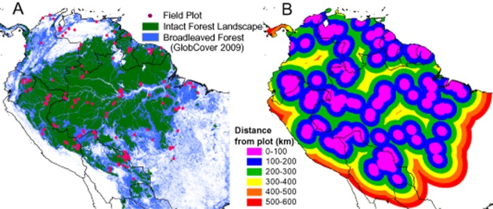
Two recent pantropical RS maps of vegetation carbon are compared to a unique ground-plot dataset, involving tree measurements in 413 large inventory plots located in nine countries. The RS maps were compared directly to field plots, and kriging of the field data was used to allow area-based comparisons.
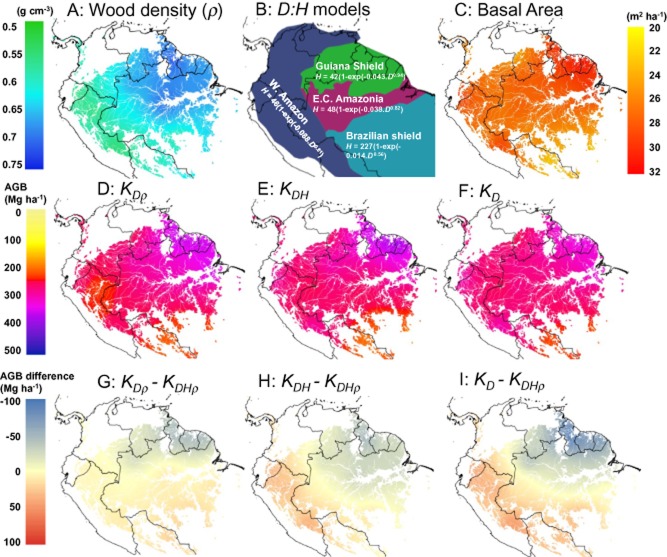
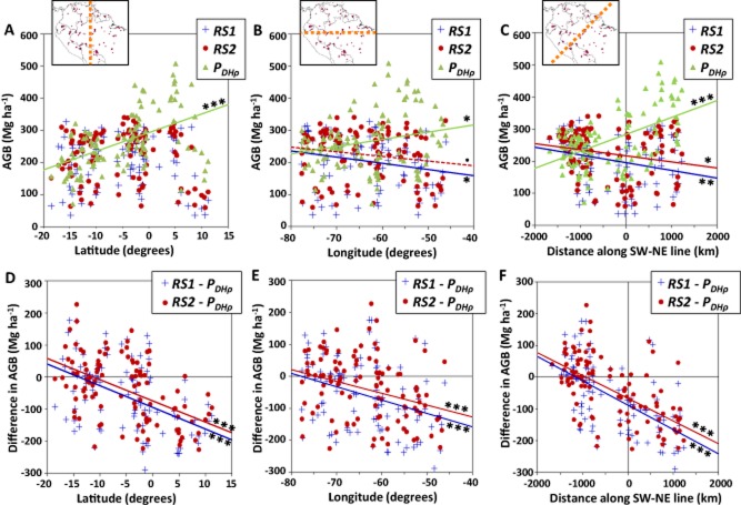
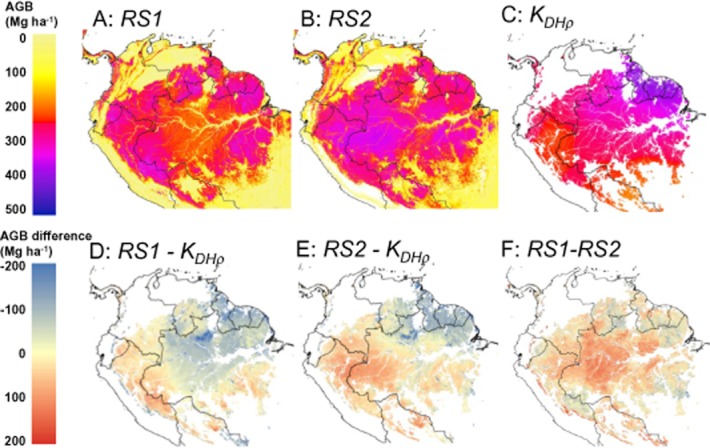
The two RS carbon maps fail to capture the main gradient in Amazon forest carbon detected using 413 ground plots, from the densely wooded tall forests of the north-east, to the light-wooded, shorter forests of the south-west. The differences between plots and RS maps far exceed the uncertainties given in these studies, with whole regions over- or under-estimated by > 25%, whereas regional uncertainties for the maps were reported to be < 5%.
Pantropical biomass maps are widely used by governments and by projects aiming to reduce deforestation using carbon offsets, but may have significant regional biases. Carbon-mapping techniques must be revised to account for the known ecological variation in tree wood density and allometry to create maps suitable for carbon accounting. The use of single relationships between tree canopy height and above-ground biomass inevitably yields large, spatially correlated errors. This presents a significant challenge to both the forest conservation and remote sensing communities, because neither wood density nor species assemblages can be reliably mapped from space.
准确绘制森林碳储量对于理解全球碳循环、评估森林砍伐造成的排放以及合理的土地利用规划至关重要。遥感(RS)是目前用于此目的的关键工具,但RS不能直接估算植被生物量,因此可能会忽略森林结构中显著的空间变化。我们使用一个大型独立实地数据集来检验泛热带碳地图的既定准确性。
亚马逊盆地的热带森林。实地样地数据的永久存档可在以下网址获取:http://dx.doi.org/10.5521/FORESTPLOTS.NET/2014_1。
将两幅近期的泛热带植被碳遥感地图与一个独特的地面样地数据集进行比较,该数据集包含对位于九个国家的413个大型清查样地中的树木测量数据。将遥感地图直接与实地样地进行比较,并使用实地数据的克里金法进行基于面积的比较。
这两幅遥感碳地图未能捕捉到利用413个地面样地检测到的亚马逊森林碳的主要梯度,即从东北部树木茂密的高大森林到西南部树木稀疏、较矮的森林。样地与遥感地图之间的差异远远超过这些研究中给出的不确定性,整个区域的高估或低估超过25%,而这些地图的区域不确定性据报道小于5%。
泛热带生物量地图被政府和旨在利用碳抵消减少森林砍伐的项目广泛使用,但可能存在显著的区域偏差。必须修订碳绘图技术,以考虑树木木材密度和异速生长方面已知的生态变化,从而创建适合碳核算的地图。使用树冠高度与地上生物量之间的单一关系不可避免地会产生大的、空间相关的误差。这对森林保护和遥感界都构成了重大挑战,因为木材密度和物种组合都无法从太空可靠地绘制出来。