Soucy Jean-Paul R, Slatculescu Andreea M, Nyiraneza Christine, Ogden Nicholas H, Leighton Patrick A, Kerr Jeremy T, Kulkarni Manisha A
1 Department of Epidemiology, Biostatistics and Occupational Health, McGill University , Montréal, Canada .
2 School of Epidemiology and Public Health, University of Ottawa , Ottawa, Canada .
Vector Borne Zoonotic Dis. 2018 May;18(5):235-242. doi: 10.1089/vbz.2017.2234. Epub 2018 Mar 22.
Lyme disease (LD) is a bacterial infection transmitted by the black-legged tick (Ixodes scapularis) in eastern North America. It is an emerging disease in Canada due to the expanding range of its tick vector. Environmental risk maps for LD, based on the distribution of the black-legged tick, have focused on coarse determinants such as climate. However, climatic factors vary little within individual health units, the level at which local public health decision-making takes place. We hypothesize that high-resolution environmental data and routinely collected passive surveillance data can be used to develop valid models for tick occurrence and provide insight into ecological processes affecting tick presence at fine scales.
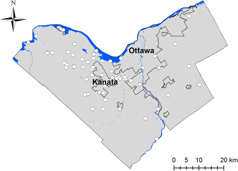
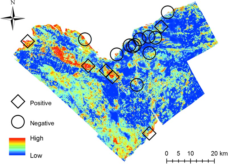
We used a maximum entropy algorithm (MaxEnt) to build a habitat suitability model for I. scapularis in Ottawa, Ontario, Canada using georeferenced occurrence points from passive surveillance data collected between 2013 and 2016 and high-resolution land cover and elevation data. We evaluated our model using an independent tick presence/absence dataset collected through active surveillance at 17 field sites during the summer of 2017.
Our model showed a good ability to discriminate positive sites from negative sites for tick presence (AUC = 0.878 ± 0.019, classification accuracy = 0.835 ± 0.020). Heavily forested suburban and rural areas in the west and southwest of Ottawa had higher predicted suitability than the more agricultural eastern areas.
This study demonstrates the value of passive surveillance data to model local-scale environmental risk for the tick vector of LD at sites of interest to public health. Given the rising incidence of LD and other emerging vector-borne diseases in Canada, our findings support the ongoing collection of these data and collaboration with researchers to provide a timely and accurate portrait of evolving public health risk.
莱姆病(LD)是一种由北美东部的黑脚蜱(肩突硬蜱)传播的细菌感染疾病。由于其蜱虫媒介分布范围的扩大,它在加拿大成为一种新兴疾病。基于黑脚蜱分布的莱姆病环境风险地图,主要关注气候等粗略的决定因素。然而,在各个卫生单位(即地方公共卫生决策所处的层面)内,气候因素变化很小。我们假设,高分辨率环境数据和常规收集的被动监测数据可用于建立蜱虫出现的有效模型,并深入了解在精细尺度上影响蜱虫存在的生态过程。
我们使用最大熵算法(MaxEnt),利用2013年至2016年收集的被动监测数据中的地理参考出现点以及高分辨率土地覆盖和海拔数据,为加拿大安大略省渥太华的肩突硬蜱建立栖息地适宜性模型。我们使用2017年夏季在17个野外地点通过主动监测收集的独立蜱虫存在/不存在数据集对模型进行评估。
我们的模型在区分蜱虫存在的阳性地点和阴性地点方面表现出良好能力(AUC = 0.878 ± 0.019,分类准确率 = 0.835 ± 0.020)。渥太华西部和西南部森林茂密的郊区和农村地区的预测适宜性高于农业化程度更高的东部地区。
本研究证明了被动监测数据对于在公共卫生感兴趣的地点建立莱姆病蜱虫媒介的局部环境风险模型的价值。鉴于加拿大莱姆病和其他新兴媒介传播疾病的发病率不断上升,我们的研究结果支持持续收集这些数据,并与研究人员合作,以及时、准确地描绘不断演变的公共卫生风险。