• 文献检索
  • 文档翻译
  • 深度研究
  • 学术资讯
  • Suppr Zotero 插件Zotero 插件
  • 邀请有礼
  • 套餐&价格
  • 历史记录
应用&插件
Suppr Zotero 插件Zotero 插件浏览器插件Mac 客户端Windows 客户端微信小程序
定价
高级版会员购买积分包购买API积分包
服务
文献检索文档翻译深度研究API 文档MCP 服务
关于我们
关于 Suppr公司介绍联系我们用户协议隐私条款
关注我们

Suppr 超能文献

核心技术专利:CN118964589B侵权必究
粤ICP备2023148730 号-1Suppr @ 2026

文献检索

告别复杂PubMed语法,用中文像聊天一样搜索,搜遍4000万医学文献。AI智能推荐,让科研检索更轻松。

立即免费搜索

文件翻译

保留排版,准确专业,支持PDF/Word/PPT等文件格式,支持 12+语言互译。

免费翻译文档

深度研究

AI帮你快速写综述,25分钟生成高质量综述,智能提取关键信息,辅助科研写作。

立即免费体验

基于自动识别系统传输中的异常现象检测海上可疑活动。

Detecting suspicious activities at sea based on anomalies in Automatic Identification Systems transmissions.

机构信息

CSIRO Data61, Castray Esplanade, Hobart, Tasmania, Australia.

Skytruth, Shepherdstown, West Virginia, United States of America.

出版信息

PLoS One. 2018 Aug 9;13(8):e0201640. doi: 10.1371/journal.pone.0201640. eCollection 2018.

DOI:10.1371/journal.pone.0201640
PMID:30091985
原文链接:https://pmc.ncbi.nlm.nih.gov/articles/PMC6084947/
Abstract

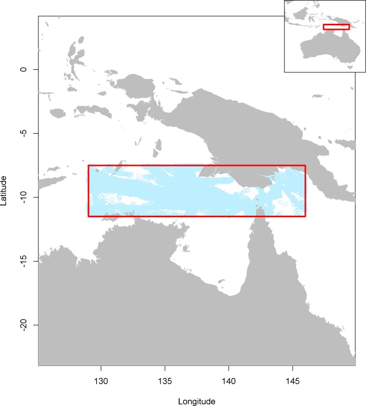
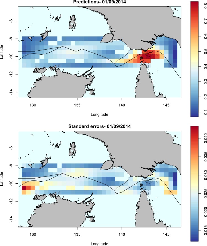
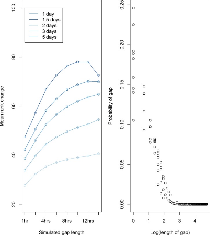
Automatic Identification Systems (AIS) are a standard feature of ocean-going vessels, designed to allow vessels to notify each other of their position and route, to reduce collisions. Increasingly, the system is being used to monitor vessels remotely, particularly with the advent of satellite receivers. One fundamental problem with AIS transmission is the issue of gaps in transmissions. Gaps occur for three basic reasons: 1) saturation of the system in locations with high vessel density; 2) poor quality transmissions due to equipment on the vessel or receiver; and 3) intentional disabling of AIS transmitters. Resolving which of these mechanisms is responsible for generating gaps in transmissions from a given vessel is a critical task in using AIS to remotely monitor vessels. Moreover, separating saturation and equipment issues from intentional disabling is a key issue, as intentional disabling is a useful risk factor in predicting illicit behaviors such as illegal fishing. We describe a spatial statistical model developed to identify gaps in AIS transmission, which allows calculation of the probability that a given gap is due to intentional disabling. The model we developed successfully identifies high risk gaps in the test case example in the Arafura Sea. Simulations support that the model is sensitive to frequent gaps as short as one hour. Results in this case study area indicate expected high risk vessels were ranked highly for risk of intentional disabling of AIS transmitters. We discuss our findings in the context of improving enforcement opportunities to reduce illicit activities at sea.

摘要

自动识别系统 (AIS) 是远洋船舶的标准功能,旨在允许船舶相互通知其位置和航线,以减少碰撞。该系统越来越多地被用于远程监控船舶,特别是随着卫星接收器的出现。AIS 传输的一个基本问题是传输中断的问题。中断的原因有三个基本原因:1) 在船舶密度高的地方系统饱和;2) 由于船舶或接收器上的设备,传输质量差;3) 故意禁用 AIS 发射器。确定这些机制中的哪一个是导致从给定船舶传输中断的原因,是使用 AIS 远程监控船舶的关键任务。此外,将饱和和设备问题与故意禁用区分开来是一个关键问题,因为故意禁用是预测非法行为(如非法捕鱼)的有用风险因素。我们描述了一种空间统计模型,该模型用于识别 AIS 传输中的间隙,可以计算给定间隙是由于故意禁用引起的概率。我们开发的模型成功地识别了阿拉弗拉海测试案例中的高风险间隙。模拟支持该模型对短至一小时的频繁间隙很敏感。在该案例研究区域的结果表明,预期高风险船舶在故意禁用 AIS 发射器方面的风险排名很高。我们在改善执法机会以减少海上非法活动的背景下讨论了我们的发现。

https://cdn.ncbi.nlm.nih.gov/pmc/blobs/11b7/6084947/66734245a2b2/pone.0201640.g004.jpg
https://cdn.ncbi.nlm.nih.gov/pmc/blobs/11b7/6084947/30ea9d96f054/pone.0201640.g001.jpg
https://cdn.ncbi.nlm.nih.gov/pmc/blobs/11b7/6084947/f1d6b80462a0/pone.0201640.g002.jpg
https://cdn.ncbi.nlm.nih.gov/pmc/blobs/11b7/6084947/6b31e20acbb9/pone.0201640.g003.jpg
https://cdn.ncbi.nlm.nih.gov/pmc/blobs/11b7/6084947/66734245a2b2/pone.0201640.g004.jpg

相似文献

1
Detecting suspicious activities at sea based on anomalies in Automatic Identification Systems transmissions.基于自动识别系统传输中的异常现象检测海上可疑活动。
PLoS One. 2018 Aug 9;13(8):e0201640. doi: 10.1371/journal.pone.0201640. eCollection 2018.
2
Completing fishing monitoring with spaceborne Vessel Detection System (VDS) and Automatic Identification System (AIS) to assess illegal fishing in Indonesia.利用星载船只探测系统(VDS)和自动识别系统(AIS)完成渔业监测,以评估印度尼西亚的非法捕捞活动。
Mar Pollut Bull. 2018 Jun;131(Pt B):33-39. doi: 10.1016/j.marpolbul.2017.10.016. Epub 2017 Oct 26.
3
Improving Fishing Pattern Detection from Satellite AIS Using Data Mining and Machine Learning.利用数据挖掘和机器学习改进基于卫星自动识别系统的捕鱼模式检测
PLoS One. 2016 Jul 1;11(7):e0158248. doi: 10.1371/journal.pone.0158248. eCollection 2016.
4
Loitering with intent-Catching the outlier vessels at sea.蓄意闲逛——在海上捕获异常船只。
PLoS One. 2018 Jul 12;13(7):e0200189. doi: 10.1371/journal.pone.0200189. eCollection 2018.
5
Ocean sentinel albatrosses locate illegal vessels and provide the first estimate of the extent of nondeclared fishing.海洋监测信天翁能够定位非法船只,并对未申报捕鱼活动的范围进行初步估计。
Proc Natl Acad Sci U S A. 2020 Feb 11;117(6):3006-3014. doi: 10.1073/pnas.1915499117. Epub 2020 Jan 27.
6
The dynamics of the fishing fleet in China Seas: A glimpse through AIS monitoring.中国海域渔船船队的动态:通过 AIS 监测一瞥。
Sci Total Environ. 2022 May 1;819:153150. doi: 10.1016/j.scitotenv.2022.153150. Epub 2022 Jan 15.
7
Mapping Fishing Effort through AIS Data.通过船舶自动识别系统(AIS)数据绘制捕鱼活动轨迹
PLoS One. 2015 Jun 22;10(6):e0130746. doi: 10.1371/journal.pone.0130746. eCollection 2015.
8
Global cooperation among diverse organizations to reduce illegal fishing in the Southern Ocean.全球范围内的多个组织合作,以减少南大洋的非法捕鱼活动。
Conserv Biol. 2012 Aug;26(4):638-48. doi: 10.1111/j.1523-1739.2012.01850.x. Epub 2012 May 24.
9
A Synergic Integration of AIS Data and SAR Imagery to Monitor Fisheries and Detect Suspicious Activities.利用 AIS 数据和 SAR 图像协同集成监测渔业和探测可疑活动。
Sensors (Basel). 2021 Apr 13;21(8):2756. doi: 10.3390/s21082756.
10
Global hot spots of transshipment of fish catch at sea.全球海洋渔获转运热点
Sci Adv. 2018 Jul 25;4(7):eaat7159. doi: 10.1126/sciadv.aat7159. eCollection 2018 Jul.

引用本文的文献

1
Leveraging port state measures to combat illegal, unreported, and unregulated fishing.利用港口国措施打击非法、未报告和无管制的捕捞活动。
Sci Adv. 2025 Sep 5;11(36):eads1592. doi: 10.1126/sciadv.ads1592.
2
Enhancing Maritime Cybersecurity through Operational Technology Sensor Data Fusion: A Comprehensive Survey and Analysis.通过运营技术传感器数据融合增强海上网络安全:全面综述与分析
Sensors (Basel). 2024 May 27;24(11):3458. doi: 10.3390/s24113458.
3
Bridging the gap in fishing effort mapping: a spatially-explicit fisheries dataset for Campanian MPAs, Italy.

本文引用的文献

1
Low-rank scale-invariant tensor product smooths for generalized additive mixed models.广义相加混合模型的低秩尺度不变张量积平滑法
Biometrics. 2006 Dec;62(4):1025-36. doi: 10.1111/j.1541-0420.2006.00574.x.
弥合渔业努力制图中的差距:意大利坎帕尼亚 MPAs 的空间明确渔业数据集。
Sci Data. 2024 Jan 9;11(1):54. doi: 10.1038/s41597-023-02883-9.
4
The global network of ports supporting high seas fishing.支持公海捕鱼的全球港口网络。
Sci Adv. 2021 Feb 26;7(9). doi: 10.1126/sciadv.abe3470. Print 2021 Feb.
5
Ocean sound levels in the northeast Pacific recorded from an autonomous underwater glider.东北太平洋自主水下滑翔机记录的海洋声音水平。
PLoS One. 2019 Nov 20;14(11):e0225325. doi: 10.1371/journal.pone.0225325. eCollection 2019.