MRC/CSO Social and Public Health Sciences Unit, University of Glasgow, Glasgow, UK.
MRC/CSO Social and Public Health Sciences Unit, University of Glasgow, Glasgow, UK.
Soc Sci Med. 2019 Mar;224:11-22. doi: 10.1016/j.socscimed.2019.01.047. Epub 2019 Jan 31.
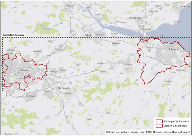
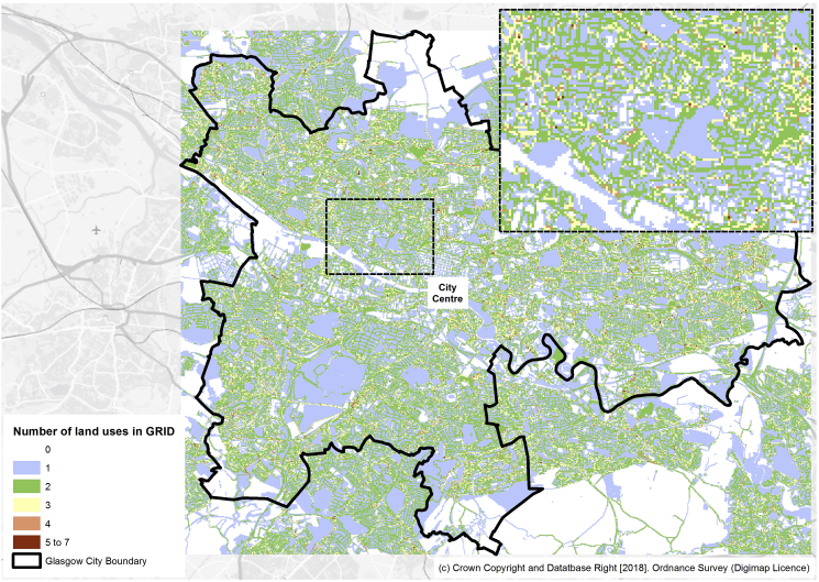
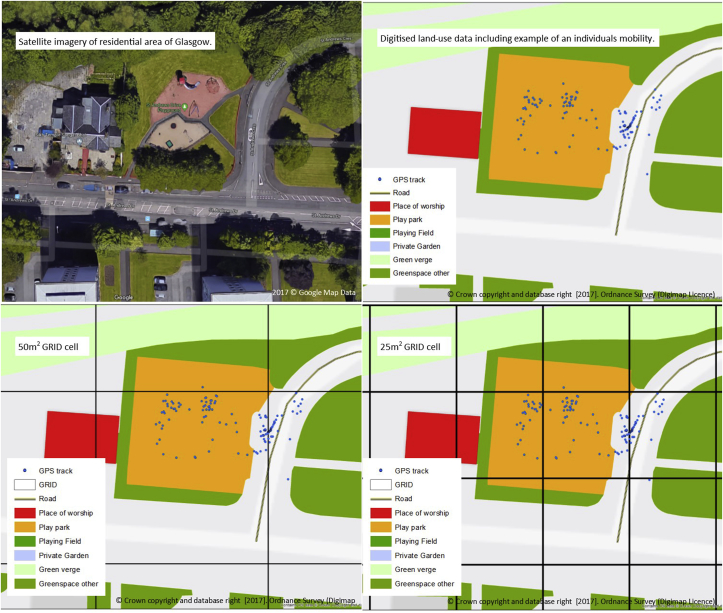
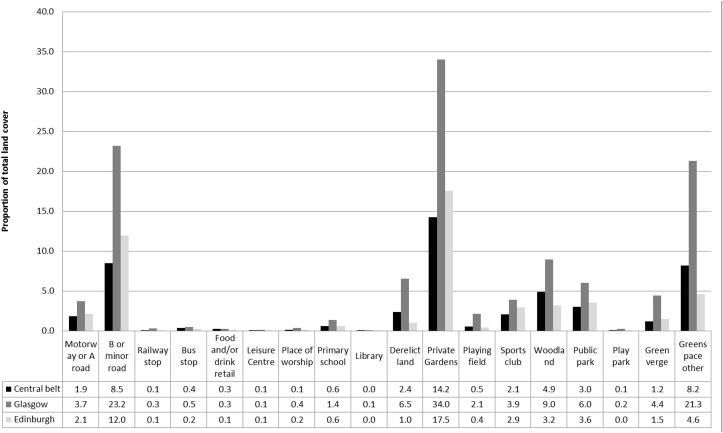
Research into how the environment affects health and related behaviour is typically limited in at least two ways: it represents the environment to which people are exposed using fixed areal units, and, it focuses on one or two environmental characteristics only. This study developed a methodology for describing children's mobility and the complexity of their environmental exposure across a 1934 km study area, including urban, suburban and rural zones. It conceptualised and modelled this area as a landscape, comprised of spatially discrete amenities, infrastructure features, differing land covers/use and broader environmental contexts. The model used a 25 m grid system (∼3 million cells). For each cell, there was detailed built-environment information. We joined data for 100 10/11-year-old children who had worn GPS trackers to provide individual-level mobility information for one week during 2015/16 to our model. Using negative binomial regression, we explored which landscape features were associated with a child visiting that space and time spent there. We examined whether relationships between the features across our study area and children's use of the space differed by their sociodemographic characteristics. We found that children often used specific amenities outside their home neighbourhood, even if they were also available close to home. They spent more time in cells containing roads/transportation stops, food/drink retail (Incidence rate ratio (IRR):4.02, 95%CI 2.33 to 6.94), places of worship (IRR:5.98, 95%CI 3.33 to 10.72) and libraries (IRR:7.40, 95%CI 2.13 to 25.68), independently of proximity to home. This has importance for the optimal location of place-based health interventions. If we want to target children, we need to understand that using fixed neighbourhood boundaries may not be the best way to do it. The variations we found in time spent in certain areas by sex and socio-economic position also raise the possibility that interventions which ignore these differences may exacerbate inequalities.
它使用固定的面积单位来代表人们所接触的环境,并且只关注一两个环境特征。本研究开发了一种方法,用于描述儿童在 1934 公里研究区域内的移动性和环境暴露的复杂性,包括城市、郊区和农村地区。它将该区域概念化为一个景观,由空间离散的设施、基础设施特征、不同的土地覆盖/用途和更广泛的环境背景组成。该模型使用 25 米的网格系统(约 300 万个单元格)。对于每个单元格,都有详细的建筑环境信息。我们将在 2015/16 年期间佩戴 GPS 追踪器的 100 名 10/11 岁儿童的个人移动信息加入我们的模型。我们使用负二项回归探索了哪些景观特征与儿童访问该空间和在该空间停留的时间有关。我们检查了在我们的研究区域内,这些特征与儿童对空间的使用之间的关系是否因他们的社会人口特征而异。我们发现,即使这些设施也在离家较近的地方,孩子们也经常在离家较远的特定设施外使用。他们在包含道路/交通站点、食品/饮料零售(发病率比 (IRR):4.02,95%CI 2.33 至 6.94)、礼拜场所(IRR:5.98,95%CI 3.33 至 10.72)和图书馆(IRR:7.40,95%CI 2.13 至 25.68)的单元格中花费的时间更多,而与离家的距离无关。这对于基于地点的健康干预措施的最佳位置具有重要意义。如果我们想针对儿童,就需要明白,使用固定的邻里边界可能不是最好的方法。我们还发现,在某些地区,性别和社会经济地位不同的儿童所花费的时间也存在差异,这表明忽略这些差异的干预措施可能会加剧不平等现象。