University of California, Berkeley, School of Public Health, Berkeley, California.
School of Public Health, 2121 Berkeley Way #5302, University of California, Berkeley, Berkeley, CA 94720. Email:
Prev Chronic Dis. 2020 Jul 9;17:E58. doi: 10.5888/pcd17.200246.
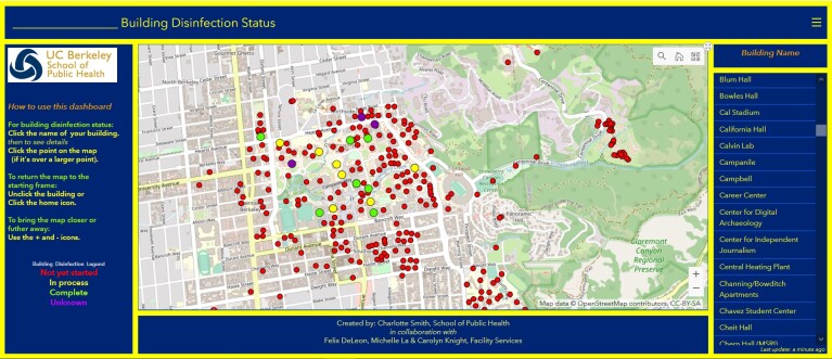
Incorporating geographic information science and technology (GIS&T) into COVID-19 pandemic surveillance, modeling, and response enhances understanding and control of the disease. Applications of GIS&T include 1) developing spatial data infrastructures for surveillance and data sharing, 2) incorporating mobility data in infectious disease forecasting, 3) using geospatial technologies for digital contact tracing, 4) integrating geographic data in COVID-19 modeling, 5) investigating geographic social vulnerabilities and health disparities, and 6) communicating the status of the disease or status of facilities for return-to-normal operations. Locations and availability of personal protective equipment, ventilators, hospital beds, and other items can be optimized with the use of GIS&T. Challenges include protection of individual privacy and civil liberties and closer collaboration among the fields of geography, medicine, public health, and public policy.
将地理信息科学和技术(GIS&T)应用于 COVID-19 大流行的监测、建模和应对中,可以增强对该疾病的理解和控制。GIS&T 的应用包括:1)开发用于监测和数据共享的空间数据基础设施;2)在传染病预测中纳入流动性数据;3)利用地理空间技术进行数字接触者追踪;4)在 COVID-19 建模中整合地理数据;5)调查地理社会脆弱性和健康差距;6)传达疾病状况或恢复正常运营的设施状况。利用 GIS&T 可以优化个人防护设备、呼吸机、病床和其他物品的位置和可用性。面临的挑战包括保护个人隐私和公民自由,以及加强地理、医学、公共卫生和公共政策领域之间的合作。