Post Graduation Program in Health and Biological Sciences, Federal University of São Francisco Valley (UNIVASF), Av. José de Sá Maniçoba, s/n, Centro, Petrolina, PE, Brazil.
Post Graduation Program in Bioscience, Federal University of São Francisco Valley (UNIVASF), Petrolina, Brazil.
Infect Dis Poverty. 2020 Nov 3;9(1):153. doi: 10.1186/s40249-020-00772-6.
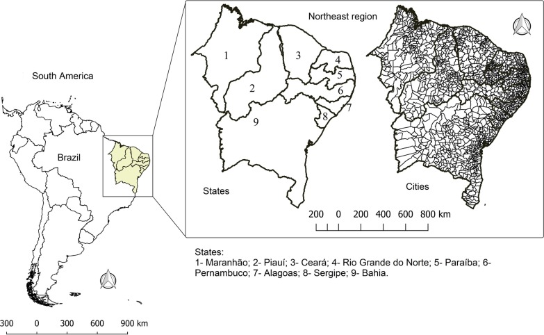
Dengue fever is an arthropod-borne viral disease caused by dengue virus (DENV) and transmitted by Aedes mosquitoes. The Northeast region of Brazil is characterized by having one of the highest dengue rates in the country, in addition to being considered the poorest region. Here, we aimed to identify spatial clusters with the highest dengue risk, as well as to analyze the temporal behavior of the incidence rate and the effects of social determinants on the disease transmission dynamic in Northeastern Brazil.
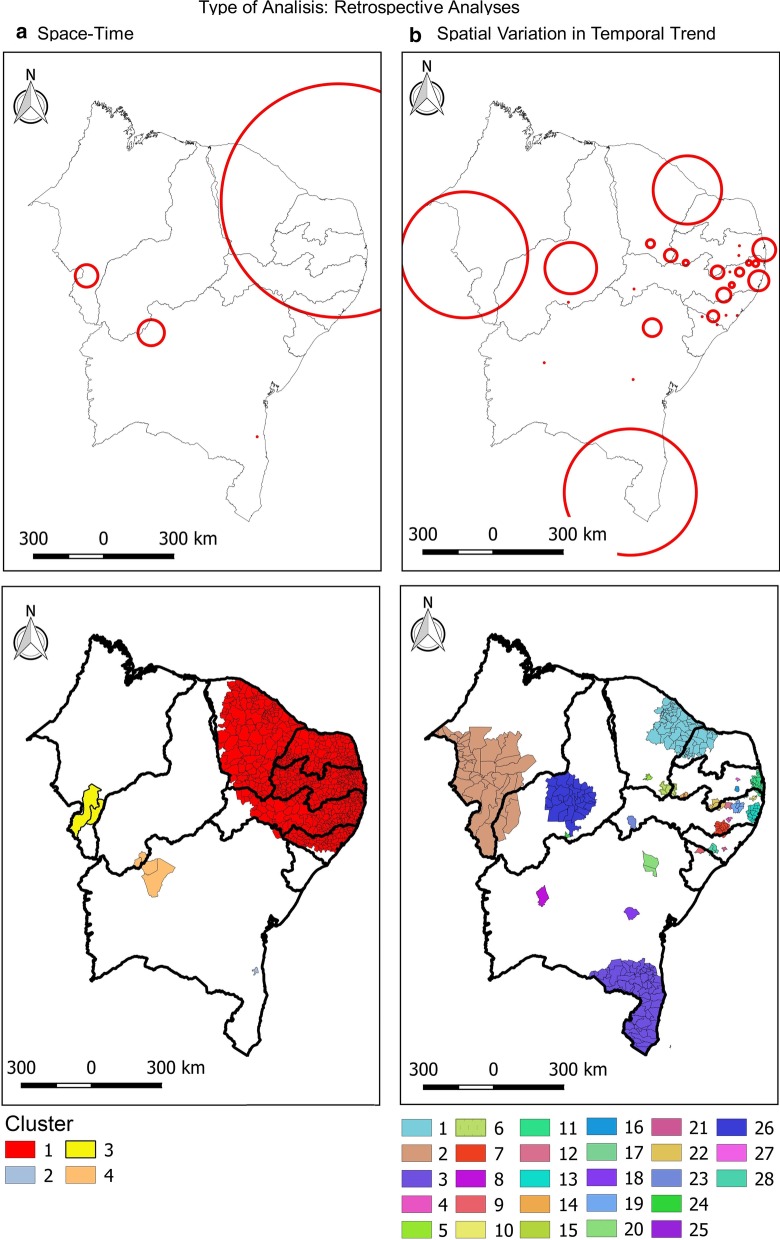
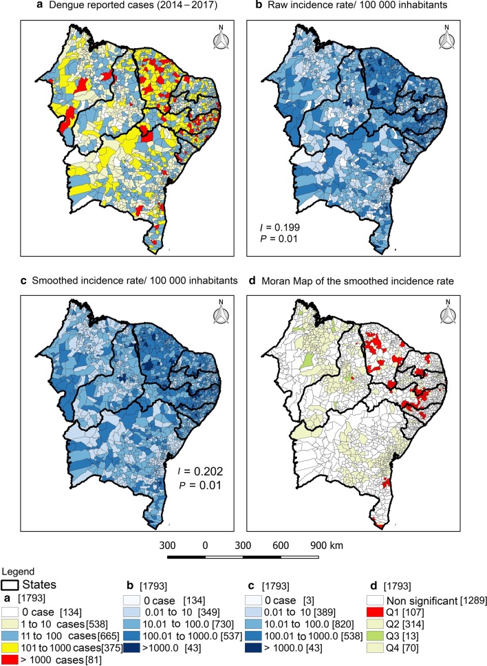
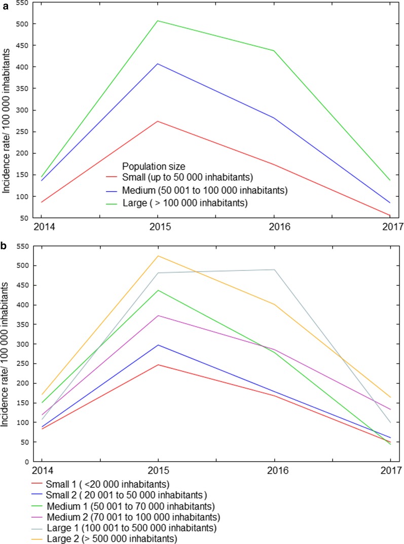
This is an ecological study carried out with all confirmed cases of dengue in the Northeast Brazil between 2014 and 2017. Data were extracted from the National Notifiable Diseases Information System (SINAN) and the Brazilian Institute of Geography and Statistics (IBGE). Local empirical Bayesian model, Moran statistics and spatial scan statistics were applied. The association between dengue incidence rate and social determinants was tested using Moran's bivariate correlation.
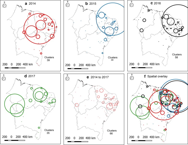
A total of 509 261 cases of dengue were confirmed in the Northeast during the study period, 53.41% of them were concentrated in Pernambuco and Ceará states. Spatial analysis showed a heterogeneous distribution of dengue cases in the region, with the highest rates in the east coast. Four risk clusters were observed, involving 815 municipalities (45.45%). Moreover, social indicators related to population density, education, income, housing, and social vulnerability showed a spatial correlation with the dengue incidence rate.
This study provides information on the spatial dynamics of dengue in northeastern Brazil and its relationship with social determinants and can be used in the formulation of public health policies to reduce the impact of the disease in vulnerable populations.
登革热是一种由登革病毒(DENV)引起的虫媒病毒性疾病,通过埃及伊蚊传播。巴西东北部的特点是该国登革热发病率最高之一,此外,该地区被认为是最贫穷的地区。在这里,我们旨在确定具有最高登革热风险的空间聚集区,并分析发病率的时间行为以及社会决定因素对该疾病在巴西东北部传播动态的影响。
这是一项在 2014 年至 2017 年间在巴西东北部进行的所有确诊登革热病例的生态研究。数据从国家法定传染病信息系统(SINAN)和巴西地理与统计研究所(IBGE)中提取。应用局部经验贝叶斯模型、莫兰统计和空间扫描统计。使用莫兰二元相关检验分析登革热发病率与社会决定因素之间的关联。
在研究期间,巴西东北部共确诊 509261 例登革热病例,其中 53.41%集中在伯南布哥州和塞阿拉州。空间分析显示该地区登革热病例分布不均,东海岸发病率最高。观察到四个风险聚集区,涉及 815 个市(45.45%)。此外,与人口密度、教育、收入、住房和社会脆弱性相关的社会指标与登革热发病率呈空间相关。
本研究提供了巴西东北部登革热的空间动态及其与社会决定因素的关系信息,可用于制定公共卫生政策,以减少脆弱人群中疾病的影响。