BSc. Assistant Professor, Department of Biological Sciences, Universidade de Pernambuco (UPE), Garanhuns (PE), Brazil.
MSc, PhD. Research Collaborator, School of Medical Sciences, Institute of Biological Sciences, Universidade de Pernambuco (UPE), Recife (PE), Brazil.
Sao Paulo Med J. 2020 Nov-Dec;138(6):554-560. doi: 10.1590/1516-3180.2020.0111.R1.24092020.
Dengue is an arbovirus that has caused serious problem in Brazil, putting the public health system under severe stress. Understanding its incidence and spatial distribution is essential for disease control and prevention.
To perform an analysis on dengue incidence and spatial distribution in a medium-sized, cool-climate and high-altitude city.
Ecological study carried out in a public institution in the city of Garanhuns, Pernambuco, Brazil.
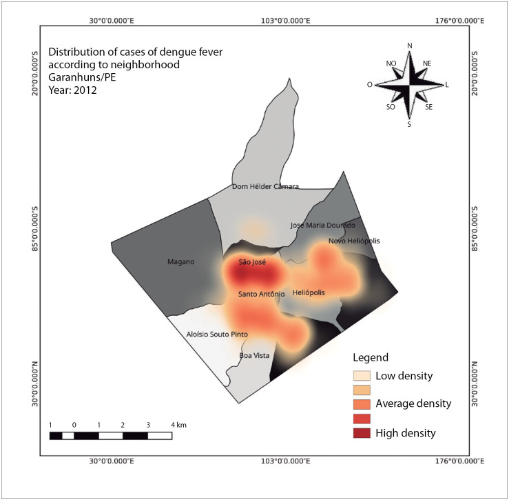
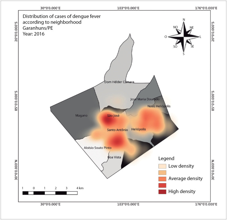
Secondary data provided by specific agencies in each area were used for spatial analysis and elaboration of kernel maps, incidence calculations, correlations and percentages of dengue occurrence. The Geocentric Reference System for the Americas (Sistema de Referência Geocêntrico para as Américas, SIRGAS), 2000, was the software of choice.
The incidence rates were calculated per 100,000 inhabitants. Between 2010 and 2019, there were 6,504 cases and the incidence was 474.92. From 2010 to 2014, the incidence was 161.46 for a total of 1,069 cases. The highest incidence occurred in the period from 2015 to 2019: out of a total of 5,435 cases, the incidence was 748.65, representing an increase of 485.97%. Population density and the interaction between two climatic factors, i.e. atypical temperature above 31 °C and relative humidity above 31.4%, contributed to the peak incidence of dengue, although these variables were not statistically significant (P > 0.05).
The dengue incidence levels and spatial distribution reflected virus and vector adjustment to the local climate. However, there was no correlation between climatic factors and occurrences of dengue in this city.
登革热是一种虫媒病毒,在巴西造成了严重问题,使公共卫生系统承受巨大压力。了解其发病率和空间分布对于疾病控制和预防至关重要。
分析中高海拔凉爽气候城市的登革热发病率和空间分布。
在巴西伯南布哥州加兰茹斯市的一家公立机构进行的生态研究。
使用各地区特定机构提供的二手数据进行空间分析和核密度图编制、发病率计算、相关性和登革热发生百分比。选择的软件是美洲地心参考系统(Sistema de Referência Geocêntrico para as Américas,SIRGAS),2000 年版。
计算每 10 万居民的发病率。2010 年至 2019 年期间,共有 6504 例病例,发病率为 474.92。2010 年至 2014 年期间,总共有 1069 例病例,发病率为 161.46。发病率最高的时期是 2015 年至 2019 年:共有 5435 例病例,发病率为 748.65,增长了 485.97%。人口密度和两种气候因素之间的相互作用,即温度超过 31°C 的非典型温度和相对湿度超过 31.4%,导致了登革热发病率的高峰,尽管这些变量没有统计学意义(P > 0.05)。
登革热的发病率水平和空间分布反映了病毒和媒介对当地气候的适应。然而,在这个城市,气候因素与登革热的发生之间没有相关性。