Yu Xueying, Millet Dylan B, Wells Kelley C, Henze Daven K, Cao Hansen, Griffis Timothy J, Kort Eric A, Plant Genevieve, Deventer Malte J, Kolka Randall K, Roman D Tyler, Davis Kenneth J, Desai Ankur R, Baier Bianca C, McKain Kathryn, Czarnetzki Alan C, Bloom A Anthony
Department of Soil, Water, and Climate, University of Minnesota, Saint Paul, Minnesota 55108, United States.
Department of Mechanical Engineering, University of Colorado Boulder, Boulder, Colorado 80309, United States.
Atmos Chem Phys. 2021 Jan;21(2):951-971. doi: 10.5194/acp-21-951-2021. Epub 2021 Jan 25.
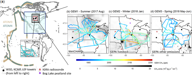
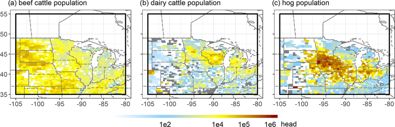
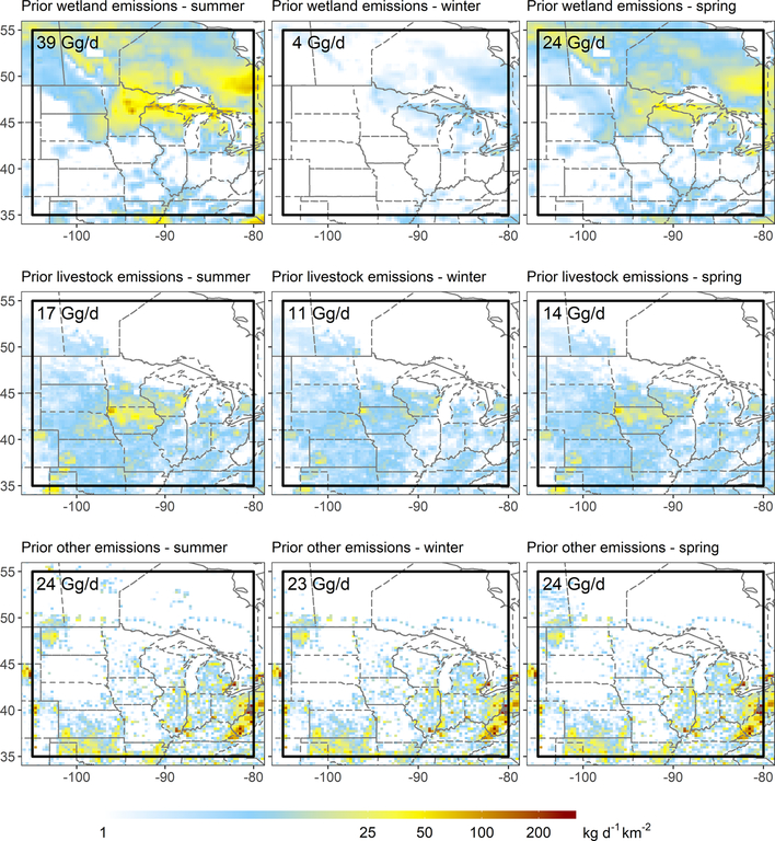
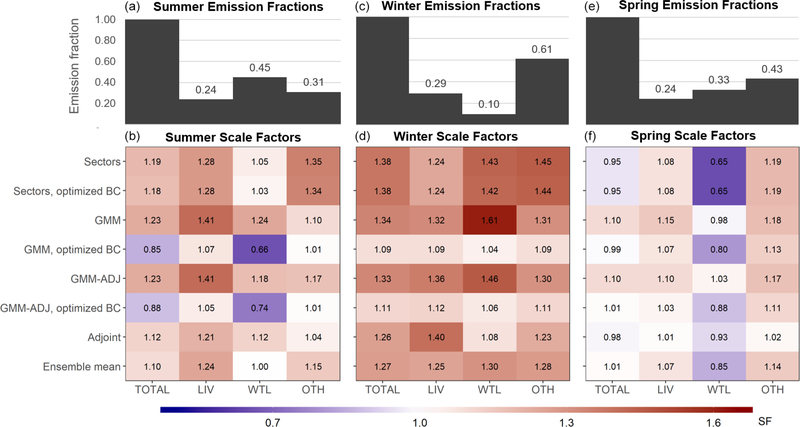
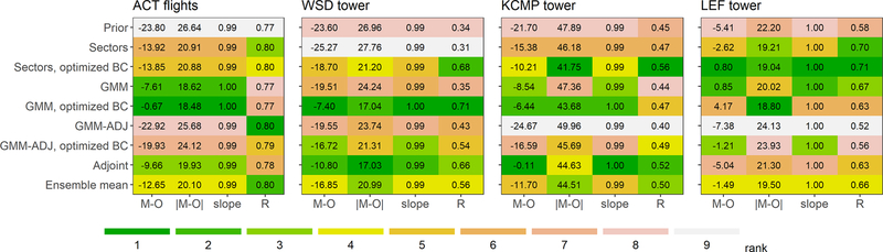
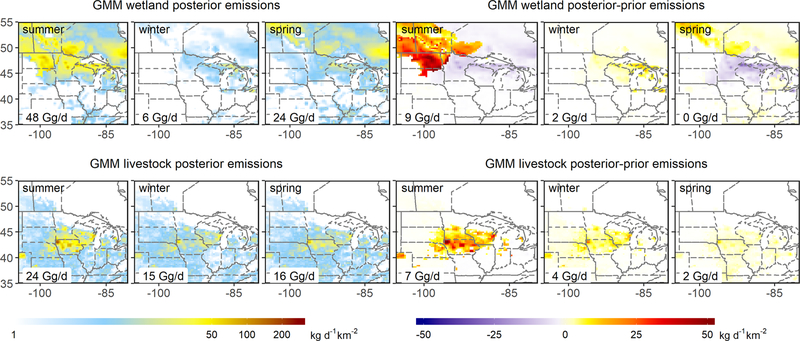
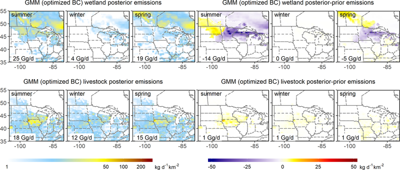
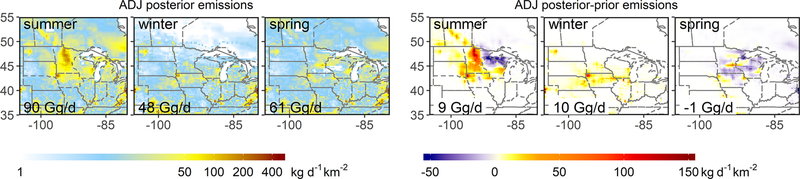
We apply airborne measurements across three seasons (summer, winter and spring 2017-2018) in a multi-inversion framework to quantify methane emissions from the US Corn Belt and Upper Midwest, a key agricultural and wetland source region. Combing our seasonal results with prior fall values we find that wetlands are the largest regional methane source (32 %, 20 [16-23] Gg/d), while livestock (enteric/manure; 25 %, 15 [14-17] Gg/d) are the largest anthropogenic source. Natural gas/petroleum, waste/landfills, and coal mines collectively make up the remainder. Optimized fluxes improve model agreement with independent datasets within and beyond the study timeframe. Inversions reveal coherent and seasonally dependent spatial errors in the WetCHARTs ensemble mean wetland emissions, with an underestimate for the Prairie Pothole region but an overestimate for Great Lakes coastal wetlands. Wetland extent and emission temperature dependence have the largest influence on prediction accuracy; better representation of coupled soil temperature-hydrology effects is therefore needed. Our optimized regional livestock emissions agree well with the Gridded EPA estimates during spring (to within 7 %) but are ∼25 % higher during summer and winter. Spatial analysis further shows good top-down and bottom-up agreement for beef facilities (with mainly enteric emissions) but larger (∼30 %) seasonal discrepancies for dairies and hog farms (with >40 % manure emissions). Findings thus support bottom-up enteric emission estimates but suggest errors for manure; we propose that the latter reflects inadequate treatment of management factors including field application. Overall, our results confirm the importance of intensive animal agriculture for regional methane emissions, implying substantial mitigation opportunities through improved management.
我们在一个多反演框架中,于三个季节(2017 - 2018年夏季、冬季和春季)进行了机载测量,以量化美国玉米带和中西部上游地区的甲烷排放,该地区是一个重要的农业和湿地源区。将我们的季节性结果与之前秋季的值相结合,我们发现湿地是最大的区域甲烷源(32%,20[16 - 23]Gg/天),而牲畜(肠道/粪便;25%,15[14 - 17]Gg/天)是最大的人为源。天然气/石油、废物/垃圾填埋场和煤矿共同构成其余部分。优化后的通量提高了模型与研究时间范围内外独立数据集的一致性。反演揭示了WetCHARTs集合平均湿地排放中存在连贯且季节性相关的空间误差,对草原坑洼地区的排放估计偏低,而对五大湖沿岸湿地的排放估计偏高。湿地范围和排放温度依赖性对预测准确性影响最大;因此需要更好地表示土壤温度 - 水文耦合效应。我们优化后的区域牲畜排放与美国环保署春季的网格化估计值吻合良好(误差在7%以内),但在夏季和冬季高出约25%。空间分析进一步表明,牛肉养殖场(主要是肠道排放)的自上而下和自下而上的一致性良好,但奶牛场和养猪场(粪便排放>40%)的季节性差异较大(约30%)。因此,研究结果支持自下而上的肠道排放估计,但表明粪便排放存在误差;我们认为后者反映了包括田间施用在内的管理因素处理不当。总体而言,我们的结果证实了集约化畜牧业对区域甲烷排放的重要性,这意味着通过改进管理有大量的减排机会。