Animal Health Program, International Livestock Research Institute, Nairobi, Kenya.
Department of Environmental Science and Land Resources Management, School of Environment, Water and Natural Resources, South Eastern Kenya University, Kitui, Kenya.
PLoS Negl Trop Dis. 2021 Mar 29;15(3):e0009301. doi: 10.1371/journal.pntd.0009301. eCollection 2021 Mar.
Anthrax is an important zoonotic disease in Kenya associated with high animal and public health burden and widespread socio-economic impacts. The disease occurs in sporadic outbreaks that involve livestock, wildlife, and humans, but knowledge on factors that affect the geographic distribution of these outbreaks is limited, challenging public health intervention planning.
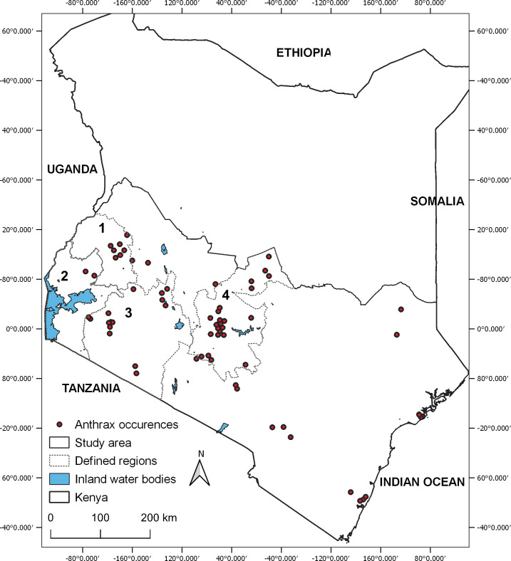
Anthrax surveillance data reported in southern Kenya from 2011 to 2017 were modeled using a boosted regression trees (BRT) framework. An ensemble of 100 BRT experiments was developed using a variable set of 18 environmental covariates and 69 unique anthrax locations. Model performance was evaluated using AUC (area under the curve) ROC (receiver operating characteristics) curves.
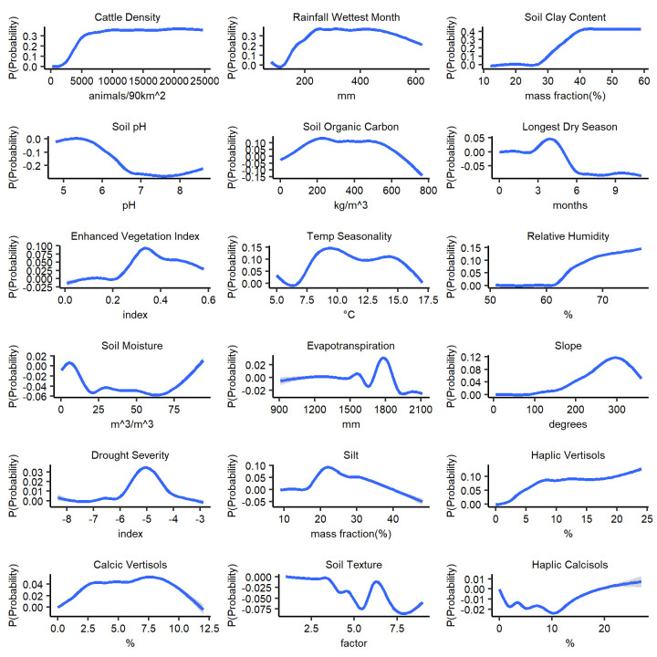
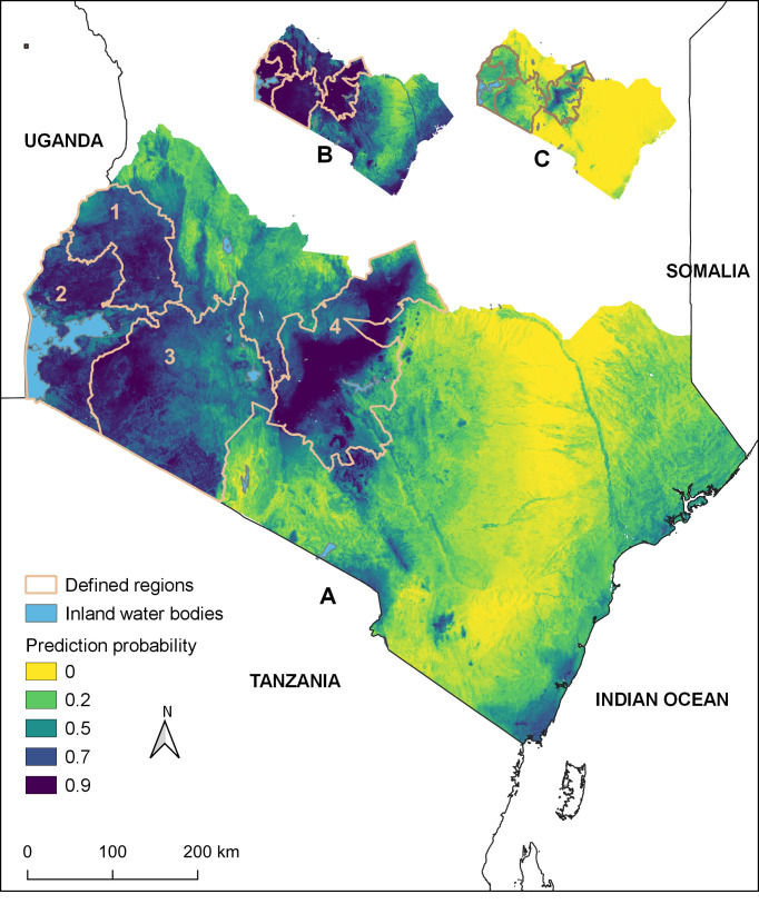
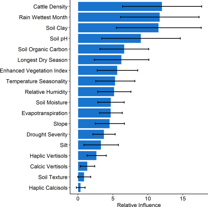
Cattle density, rainfall of wettest month, soil clay content, soil pH, soil organic carbon, length of longest dry season, vegetation index, temperature seasonality, in order, were identified as key variables for predicting environmental suitability for anthrax in the region. BRTs performed well with a mean AUC of 0.8. Areas highly suitable for anthrax were predicted predominantly in the southwestern region around the shared Kenya-Tanzania border and a belt through the regions and highlands in central Kenya. These suitable regions extend westwards to cover large areas in western highlands and the western regions around Lake Victoria and bordering Uganda. The entire eastern and lower-eastern regions towards the coastal region were predicted to have lower suitability for anthrax.
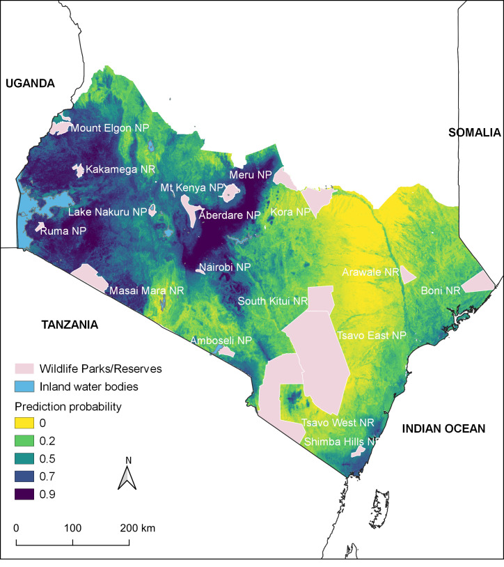
These modeling efforts identified areas of anthrax suitability across southern Kenya, including high and medium agricultural potential regions and wildlife parks, important for tourism and foreign exchange. These predictions are useful for policy makers in designing targeted surveillance and/or control interventions in Kenya. We thank the staff of Directorate of Veterinary Services under the Ministry of Agriculture, Livestock and Fisheries, for collecting and providing the anthrax historical occurrence data.
炭疽病在肯尼亚是一种重要的人畜共患病,对动物和公共卫生造成严重负担,对社会经济也产生广泛影响。该病以散发性疫情形式出现,涉及牲畜、野生动物和人类,但人们对影响这些疫情地理分布的因素知之甚少,这给公共卫生干预规划带来了挑战。
采用提升回归树(BRT)框架,对 2011 年至 2017 年肯尼亚南部地区的炭疽病监测数据进行建模。通过 18 个环境协变量和 69 个独特炭疽病地点的变量集,开发了 100 个 BRT 实验的集合。使用 AUC(曲线下面积)ROC(接受者操作特征)曲线评估模型性能。
牛密度、最湿月降雨量、土壤粘粒含量、土壤 pH 值、土壤有机碳、最长旱季长度、植被指数、温度季节性,依次被确定为该地区炭疽病环境适宜性预测的关键变量。BRT 表现良好,平均 AUC 为 0.8。高适宜度炭疽病的地区主要位于肯尼亚-坦桑尼亚边境附近的西南部地区,以及肯尼亚中部地区和高地的一条地带。这些适宜地区向西延伸,覆盖了西部高原和维多利亚湖周围以及与乌干达接壤的西部地区的大片地区。整个东部和下东部地区向沿海地区的炭疽病适宜度预测较低。
这些建模工作确定了肯尼亚南部炭疽病的适宜区域,包括高和中农业潜力地区和野生动物公园,这对旅游业和外汇收入很重要。这些预测对肯尼亚的决策者制定有针对性的监测和/或控制干预措施非常有用。我们感谢农业部、畜牧业和渔业局兽医服务局的工作人员收集并提供炭疽病历史发生数据。