• 文献检索
  • 文档翻译
  • 深度研究
  • 学术资讯
  • Suppr Zotero 插件Zotero 插件
  • 邀请有礼
  • 套餐&价格
  • 历史记录
应用&插件
Suppr Zotero 插件Zotero 插件浏览器插件Mac 客户端Windows 客户端微信小程序
定价
高级版会员购买积分包购买API积分包
服务
文献检索文档翻译深度研究API 文档MCP 服务
关于我们
关于 Suppr公司介绍联系我们用户协议隐私条款
关注我们

Suppr 超能文献

核心技术专利:CN118964589B侵权必究
粤ICP备2023148730 号-1Suppr @ 2026

文献检索

告别复杂PubMed语法,用中文像聊天一样搜索,搜遍4000万医学文献。AI智能推荐,让科研检索更轻松。

立即免费搜索

文件翻译

保留排版,准确专业,支持PDF/Word/PPT等文件格式,支持 12+语言互译。

免费翻译文档

深度研究

AI帮你快速写综述,25分钟生成高质量综述,智能提取关键信息,辅助科研写作。

立即免费体验

美国的对流层监测仪二氧化氮:对年平均值、每周周期、温度影响以及与地表二氧化氮浓度相关性的详细研究。

TROPOMI NO in the United States: A Detailed Look at the Annual Averages, Weekly Cycles, Effects of Temperature, and Correlation With Surface NO Concentrations.

作者信息

Goldberg Daniel L, Anenberg Susan C, Kerr Gaige Hunter, Mohegh Arash, Lu Zifeng, Streets David G

机构信息

Department of Environmental and Occupational Health George Washington University Washington DC USA.

Energy Systems Division Argonne National Laboratory Argonne IL USA.

出版信息

Earths Future. 2021 Apr;9(4):e2020EF001665. doi: 10.1029/2020EF001665. Epub 2021 Apr 2.

DOI:10.1029/2020EF001665
PMID:33869651
原文链接:https://pmc.ncbi.nlm.nih.gov/articles/PMC8047911/
Abstract

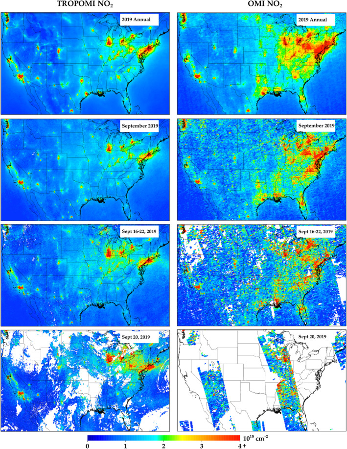
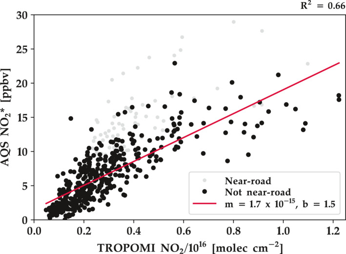
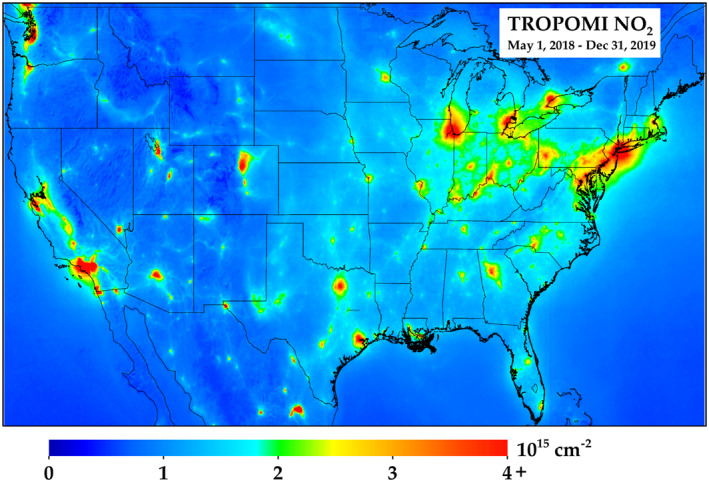
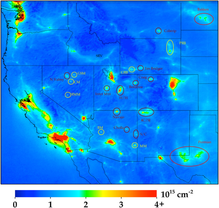
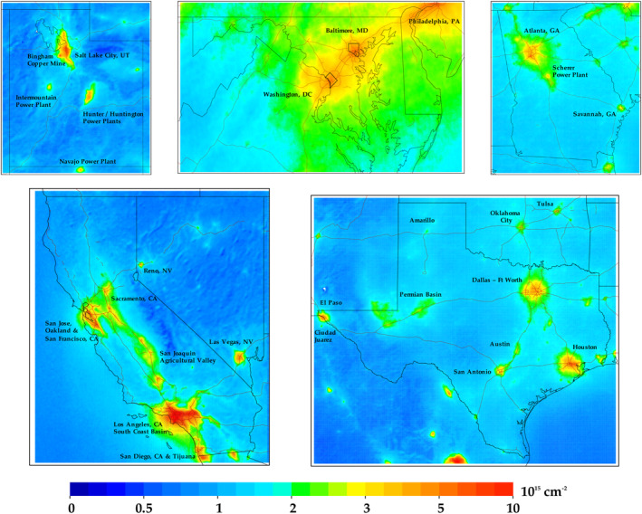
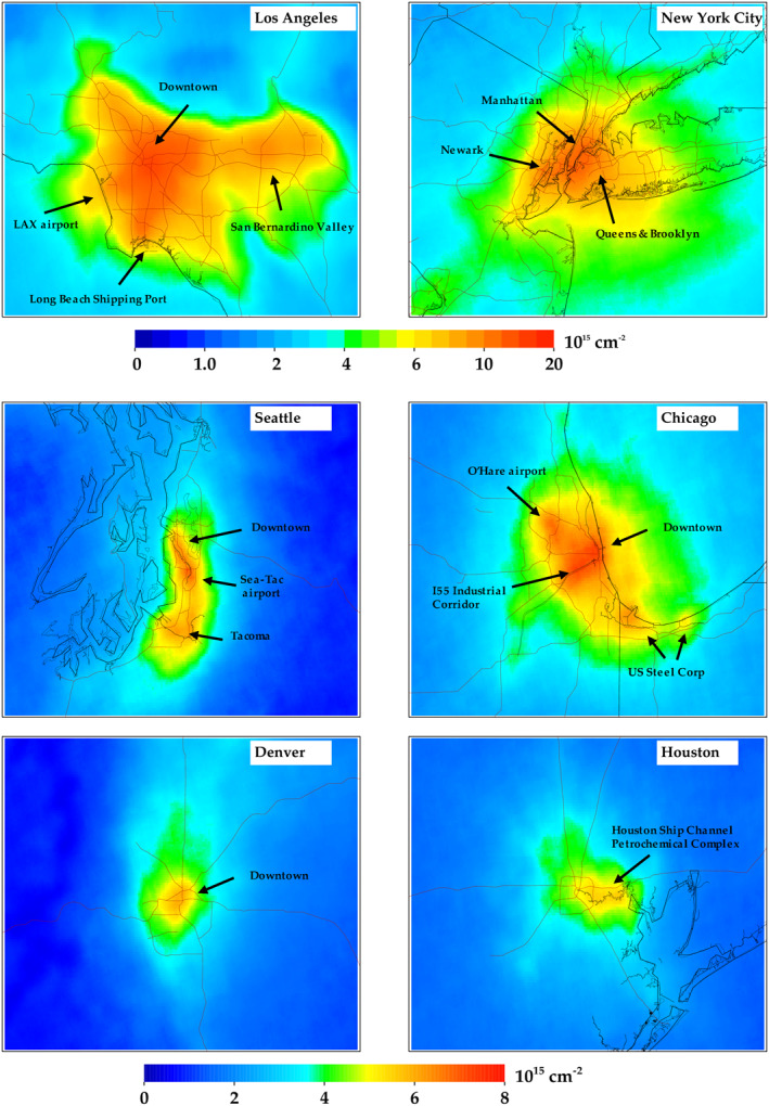
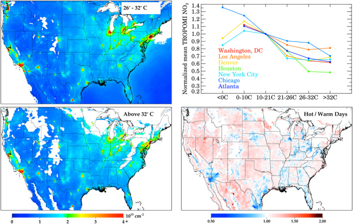
Observing the spatial heterogeneities of NO air pollution is an important first step in quantifying NO emissions and exposures. This study investigates the capabilities of the Tropospheric Monitoring Instrument (TROPOMI) in observing the spatial and temporal patterns of NO pollution in the continental United States. The unprecedented sensitivity of the sensor can differentiate the fine-scale spatial heterogeneities in urban areas, such as emissions related to airport/shipping operations and high traffic, and the relatively small emission sources in rural areas, such as power plants and mining operations. We then examine NO columns by day-of-the-week and find that Saturday and Sunday concentrations are 16% and 24% lower respectively, than during weekdays. We also analyze the correlation of daily maximum 2-m temperatures and NO column amounts and find that NO is larger on the hottest days (>32°C) as compared to warm days (26°C-32°C), which is in contrast to a general decrease in NO with increasing temperature at moderate temperatures. Finally, we demonstrate that a linear regression fit of 2019 annual TROPOMI NO data to annual surface-level concentrations yields relatively strong correlation (  = 0.66). These new developments make TROPOMI NO satellite data advantageous for policymakers and public health officials, who request information at high spatial resolution and short timescales, in order to assess, devise, and evaluate regulations.

摘要

观测一氧化氮空气污染的空间异质性是量化一氧化氮排放和暴露的重要第一步。本研究调查了对流层监测仪器(TROPOMI)在美国大陆观测一氧化氮污染的空间和时间模式的能力。该传感器前所未有的灵敏度能够区分城市地区的精细尺度空间异质性,例如与机场/航运运营和高流量交通相关的排放,以及农村地区相对较小的排放源,如发电厂和采矿作业。然后,我们按星期几检查一氧化氮柱总量,发现周六和周日的浓度分别比工作日低16%和24%。我们还分析了每日最高2米温度与一氧化氮柱总量的相关性,发现与温暖天气(26°C - 32°C)相比,在最热的日子(>32°C)一氧化氮含量更高,这与在中等温度下一氧化氮随温度升高而普遍下降的情况相反。最后,我们证明将2019年TROPOMI一氧化氮年度数据与年度地面浓度进行线性回归拟合可得到相对较强的相关性( = 0.66)。这些新进展使TROPOMI一氧化氮卫星数据对政策制定者和公共卫生官员具有优势,他们需要高空间分辨率和短时间尺度的信息,以便评估、制定和评估法规。

https://cdn.ncbi.nlm.nih.gov/pmc/blobs/9988/8047911/8c0a2e2242a2/EFT2-9-e2020EF001665-g008.jpg
https://cdn.ncbi.nlm.nih.gov/pmc/blobs/9988/8047911/260fb23967aa/EFT2-9-e2020EF001665-g006.jpg
https://cdn.ncbi.nlm.nih.gov/pmc/blobs/9988/8047911/b70e8b8abe6f/EFT2-9-e2020EF001665-g002.jpg
https://cdn.ncbi.nlm.nih.gov/pmc/blobs/9988/8047911/295349a6e92a/EFT2-9-e2020EF001665-g001.jpg
https://cdn.ncbi.nlm.nih.gov/pmc/blobs/9988/8047911/a6b1f9c6f403/EFT2-9-e2020EF001665-g004.jpg
https://cdn.ncbi.nlm.nih.gov/pmc/blobs/9988/8047911/20cf2e7f5c36/EFT2-9-e2020EF001665-g007.jpg
https://cdn.ncbi.nlm.nih.gov/pmc/blobs/9988/8047911/4389c6dad9b2/EFT2-9-e2020EF001665-g003.jpg
https://cdn.ncbi.nlm.nih.gov/pmc/blobs/9988/8047911/42578e139bb4/EFT2-9-e2020EF001665-g005.jpg
https://cdn.ncbi.nlm.nih.gov/pmc/blobs/9988/8047911/8c0a2e2242a2/EFT2-9-e2020EF001665-g008.jpg

相似文献

1
TROPOMI NO in the United States: A Detailed Look at the Annual Averages, Weekly Cycles, Effects of Temperature, and Correlation With Surface NO Concentrations.美国的对流层监测仪二氧化氮:对年平均值、每周周期、温度影响以及与地表二氧化氮浓度相关性的详细研究。
Earths Future. 2021 Apr;9(4):e2020EF001665. doi: 10.1029/2020EF001665. Epub 2021 Apr 2.
2
Observing Nitrogen Dioxide Air Pollution Inequality Using High-Spatial-Resolution Remote Sensing Measurements in Houston, Texas.利用德克萨斯州休斯顿的高空间分辨率遥感测量观察二氧化氮空气污染不平等现象。
Environ Sci Technol. 2020 Aug 18;54(16):9882-9895. doi: 10.1021/acs.est.0c01864. Epub 2020 Aug 5.
3
Mortality and Morbidity Effects of Long-Term Exposure to Low-Level PM, BC, NO, and O: An Analysis of European Cohorts in the ELAPSE Project.长期暴露于低水平 PM、BC、NO 和 O 对死亡率和发病率的影响:ELAPSE 项目中欧洲队列的分析。
Res Rep Health Eff Inst. 2021 Sep;2021(208):1-127.
4
Enhanced Capabilities of TROPOMI NO: Estimating NO from North American Cities and Power Plants.TROPOMI 硝酸盐观测能力增强:估算北美城市和发电厂的氮氧化物。
Environ Sci Technol. 2019 Nov 5;53(21):12594-12601. doi: 10.1021/acs.est.9b04488. Epub 2019 Oct 25.
5
The impact of the congestion charging scheme on air quality in London. Part 1. Emissions modeling and analysis of air pollution measurements.拥堵收费计划对伦敦空气质量的影响。第1部分。排放建模与空气污染测量分析。
Res Rep Health Eff Inst. 2011 Apr(155):5-71.
6
High resolution mapping of nitrogen dioxide with TROPOMI: First results and validation over the Canadian oil sands.利用对流层监测仪进行二氧化氮的高分辨率绘图:加拿大油砂地区的初步结果与验证
Geophys Res Lett. 2019 Jan 28;46(2):1049-1060. doi: 10.1029/2018GL081095. Epub 2018 Dec 28.
7
Estimating global 0.1° scale gridded anthropogenic CO emissions using TROPOMI NO and a data-driven method.利用TROPOMI二氧化氮数据和一种数据驱动方法估算全球0.1°尺度网格化人为一氧化碳排放量。
Sci Total Environ. 2024 Nov 1;949:175177. doi: 10.1016/j.scitotenv.2024.175177. Epub 2024 Jul 31.
8
Daily Satellite Observations of Nitrogen Dioxide Air Pollution Inequality in New York City, New York and Newark, New Jersey: Evaluation and Application.每日卫星观测纽约市和新泽新州纽瓦克市的二氧化氮空气污染不平等:评估与应用。
Environ Sci Technol. 2022 Nov 15;56(22):15298-15311. doi: 10.1021/acs.est.2c02828. Epub 2022 Oct 12.
9
Long-term spatiotemporal variations in surface NO for Beijing reconstructed from surface data and satellite retrievals.利用地面数据和卫星反演资料重建的北京地区地表一氧化氮(NO)长期时空变化。
Sci Total Environ. 2023 Dec 15;904:166693. doi: 10.1016/j.scitotenv.2023.166693. Epub 2023 Aug 30.
10
Ground-Level NO Surveillance from Space Across China for High Resolution Using Interpretable Spatiotemporally Weighted Artificial Intelligence.利用可解释的时空加权人工智能从太空对中国进行高分辨率的地面水平 NO 监测。
Environ Sci Technol. 2022 Jul 19;56(14):9988-9998. doi: 10.1021/acs.est.2c03834. Epub 2022 Jun 29.

引用本文的文献

1
Physics-Based Spatial Oversampling of TROPOMI NO Observations to US Neighborhoods Reveals the Disparities of Air Pollution.基于物理的TROPOMI氮氧化物观测对美国社区的空间过采样揭示了空气污染的差异。
Geohealth. 2025 Aug 16;9(8):e2025GH001423. doi: 10.1029/2025GH001423. eCollection 2025 Aug.
2
A data-driven supervised machine learning approach to estimating global ambient air pollution concentrations with associated prediction intervals.一种基于数据驱动的监督式机器学习方法,用于估计全球环境空气污染浓度及相关预测区间。
R Soc Open Sci. 2025 Jul 23;12(7):241288. doi: 10.1098/rsos.241288. eCollection 2025 Jul.
3
Potential Errors in CMAQ NO:NO Ratios and Upper Tropospheric NO Impacting the Interpretation of TROPOMI Retrievals.

本文引用的文献

1
Evaluating Sentinel-5P TROPOMI tropospheric NO column densities with airborne and Pandora spectrometers near New York City and Long Island Sound.利用纽约市和长岛海峡附近的机载和潘多拉光谱仪评估哨兵-5P TROPOMI对流层一氧化氮柱密度。
Atmos Meas Tech. 2020 Nov 17;13(11):6113-6140. doi: 10.5194/amt-13-6113-2020.
2
High resolution mapping of nitrogen dioxide with TROPOMI: First results and validation over the Canadian oil sands.利用对流层监测仪进行二氧化氮的高分辨率绘图:加拿大油砂地区的初步结果与验证
Geophys Res Lett. 2019 Jan 28;46(2):1049-1060. doi: 10.1029/2018GL081095. Epub 2018 Dec 28.
3
Evaluating the impact of spatial resolution on tropospheric NO column comparisons within urban areas using high-resolution airborne data.
CMAQ 中 NO:NO 比值及对流层上部 NO 的潜在误差对 TROPOMI 反演结果解释的影响
ACS EST Air. 2025 Apr 29;2(6):998-1008. doi: 10.1021/acsestair.4c00198. eCollection 2025 Jun 13.
4
TROPOMI Satellite Data Reshape NO Air Pollution Land-Use Regression Modeling Capabilities in the United States.对流层监测仪(TROPOMI)卫星数据重塑了美国氮氧化物空气污染土地利用回归模型的能力。
ACS EST Air. 2025 Jan 22;2(2):187-200. doi: 10.1021/acsestair.4c00153. eCollection 2025 Feb 14.
5
Sociodemographic and Population Exposure to Upstream Oil and Gas Operations in Canada.加拿大社会人口统计学与上游石油和天然气作业的人口暴露情况。
Int J Environ Res Public Health. 2024 Dec 19;21(12):1692. doi: 10.3390/ijerph21121692.
6
Methods for Quantifying Source-Specific Air Pollution Exposure to Serve Epidemiology, Risk Assessment, and Environmental Justice.量化特定来源空气污染暴露以服务于流行病学、风险评估和环境正义的方法。
Geohealth. 2024 Nov 5;8(11):e2024GH001188. doi: 10.1029/2024GH001188. eCollection 2024 Nov.
7
Air pollution impacts from warehousing in the United States uncovered with satellite data.利用卫星数据发现美国仓储业对空气污染的影响。
Nat Commun. 2024 Jul 24;15(1):6006. doi: 10.1038/s41467-024-50000-0.
8
Ethnoracial Disparities in Nitrogen Dioxide Pollution in the United States: Comparing Data Sets from Satellites, Models, and Monitors.美国二氧化氮污染中的民族种族差异:卫星、模型和监测器数据的比较。
Environ Sci Technol. 2023 Dec 5;57(48):19532-19544. doi: 10.1021/acs.est.3c03999. Epub 2023 Nov 7.
9
Predictability of fossil fuel CO from air quality emissions.空气质量排放物中化石燃料 CO 的可预测性。
Nat Commun. 2023 Mar 23;14(1):1604. doi: 10.1038/s41467-023-37264-8.
10
Effect of different plant communities on NO in an urban road greenbelt in Nanjing, China.不同植物群落对南京城市道路绿化带中 NO 的影响。
Sci Rep. 2023 Feb 28;13(1):3424. doi: 10.1038/s41598-023-30488-0.
利用高分辨率航空数据评估空间分辨率对城市地区对流层一氧化氮柱浓度比较的影响。
Atmos Meas Tech. 2019 Nov;12(11):6091-6111. doi: 10.5194/amt-12-6091-2019. Epub 2019 Nov 22.
4
Abrupt decline in tropospheric nitrogen dioxide over China after the outbreak of COVID-19.新冠疫情爆发后中国对流层二氧化氮的急剧下降。
Sci Adv. 2020 Jul 10;6(28):eabc2992. doi: 10.1126/sciadv.abc2992. eCollection 2020 Jul.
5
Tropospheric Emissions: Monitoring of Pollution (TEMPO).对流层排放:污染监测(TEMPO)
J Quant Spectrosc Radiat Transf. 2017 Jan;186:17-39. doi: 10.1016/j.jqsrt.2016.05.008. Epub 2016 Jun 6.
6
Assessment of NO observations during DISCOVER-AQ and KORUS-AQ field campaigns.在“大气成分观测和垂直结构探测与分析(DISCOVER-AQ)”及“美韩空气质量与气候联合观测研究(KORUS-AQ)”实地考察期间对一氧化氮观测数据的评估。
Atmos Meas Tech. 2020 May 19;13(5). doi: 10.5194/amt-13-2523-2020.
7
Satellite evidence for changes in the NO weekly cycle over large cities.卫星证据表明大城市中 NO 周循环的变化。
Sci Rep. 2020 Jun 22;10(1):10066. doi: 10.1038/s41598-020-66891-0.
8
Bayesian geostatistical modelling of high-resolution NO exposure in Europe combining data from monitors, satellites and chemical transport models.贝叶斯地统计学模型在欧洲高分辨率 NO 暴露研究中的应用,结合了监测站、卫星和化学传输模型的数据。
Environ Int. 2020 May;138:105578. doi: 10.1016/j.envint.2020.105578. Epub 2020 Mar 14.
9
Daily Satellite Observations of Methane from Oil and Gas Production Regions in the United States.美国油气生产地区甲烷的每日卫星观测
Sci Rep. 2020 Jan 28;10(1):1379. doi: 10.1038/s41598-020-57678-4.
10
Quantification of nitrogen oxides emissions from build-up of pollution over Paris with TROPOMI.利用 TROPOMI 量化巴黎地区污染积累过程中的氮氧化物排放。
Sci Rep. 2019 Dec 27;9(1):20033. doi: 10.1038/s41598-019-56428-5.