• 文献检索
  • 文档翻译
  • 深度研究
  • 学术资讯
  • Suppr Zotero 插件Zotero 插件
  • 邀请有礼
  • 套餐&价格
  • 历史记录
应用&插件
Suppr Zotero 插件Zotero 插件浏览器插件Mac 客户端Windows 客户端微信小程序
定价
高级版会员购买积分包购买API积分包
服务
文献检索文档翻译深度研究API 文档MCP 服务
关于我们
关于 Suppr公司介绍联系我们用户协议隐私条款
关注我们

Suppr 超能文献

核心技术专利:CN118964589B侵权必究
粤ICP备2023148730 号-1Suppr @ 2026

文献检索

告别复杂PubMed语法,用中文像聊天一样搜索,搜遍4000万医学文献。AI智能推荐,让科研检索更轻松。

立即免费搜索

文件翻译

保留排版,准确专业,支持PDF/Word/PPT等文件格式,支持 12+语言互译。

免费翻译文档

深度研究

AI帮你快速写综述,25分钟生成高质量综述,智能提取关键信息,辅助科研写作。

立即免费体验

揭示美国 COVID-19 大流行的空间转移模式。

Revealing the spatial shifting pattern of COVID-19 pandemic in the United States.

机构信息

Department of Geography, Environment and Society, University of Minnesota, Twin Cities, USA.

Beijing Key Lab of Spatial Information Integration and Its Applications, Peking University, Beijing, China.

出版信息

Sci Rep. 2021 Apr 19;11(1):8396. doi: 10.1038/s41598-021-87902-8.

DOI:10.1038/s41598-021-87902-8
PMID:33875751
原文链接:https://pmc.ncbi.nlm.nih.gov/articles/PMC8055907/
Abstract

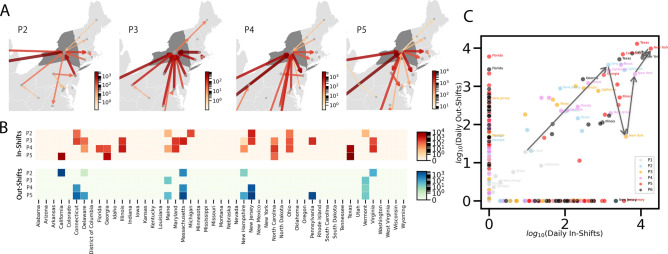
We describe the use of network modeling to capture the shifting spatiotemporal nature of the COVID-19 pandemic. The most common approach to tracking COVID-19 cases over time and space is to examine a series of maps that provide snapshots of the pandemic. A series of snapshots can convey the spatial nature of cases but often rely on subjective interpretation to assess how the pandemic is shifting in severity through time and space. We present a novel application of network optimization to a standard series of snapshots to better reveal how the spatial centres of the pandemic shifted spatially over time in the mainland United States under a mix of interventions. We find a global spatial shifting pattern with stable pandemic centres and both local and long-range interactions. Metrics derived from the daily nature of spatial shifts are introduced to help evaluate the pandemic situation at regional scales. We also highlight the value of reviewing pandemics through local spatial shifts to uncover dynamic relationships among and within regions, such as spillover and concentration among states. This new way of examining the COVID-19 pandemic in terms of network-based spatial shifts offers new story lines in understanding how the pandemic spread in geography.

摘要

我们描述了使用网络建模来捕捉 COVID-19 大流行不断变化的时空性质。跟踪 COVID-19 病例随时间和空间的变化的最常见方法是检查一系列提供大流行快照的地图。一系列快照可以传达病例的空间性质,但通常依赖于主观解释来评估大流行在时间和空间上的严重程度如何变化。我们将网络优化的新应用于标准快照系列,以更好地揭示在混合干预措施下,美国大陆 COVID-19 的空间中心如何随时间在空间上转移。我们发现了一个具有稳定大流行中心以及局部和远程相互作用的全球空间转移模式。引入了从空间转移的每日性质派生的指标,以帮助评估区域尺度上的大流行情况。我们还强调了通过局部空间转移来审查大流行病以揭示地区之间和内部的动态关系(如州之间的溢出和集中)的价值。这种基于网络的空间转移来检查 COVID-19 大流行的新方法提供了理解大流行病在地理上传播的新线索。

https://cdn.ncbi.nlm.nih.gov/pmc/blobs/2879/8055907/648c403a13cf/41598_2021_87902_Fig3_HTML.jpg
https://cdn.ncbi.nlm.nih.gov/pmc/blobs/2879/8055907/4937f32417bd/41598_2021_87902_Fig1_HTML.jpg
https://cdn.ncbi.nlm.nih.gov/pmc/blobs/2879/8055907/561fe3db2fb6/41598_2021_87902_Fig2_HTML.jpg
https://cdn.ncbi.nlm.nih.gov/pmc/blobs/2879/8055907/648c403a13cf/41598_2021_87902_Fig3_HTML.jpg
https://cdn.ncbi.nlm.nih.gov/pmc/blobs/2879/8055907/4937f32417bd/41598_2021_87902_Fig1_HTML.jpg
https://cdn.ncbi.nlm.nih.gov/pmc/blobs/2879/8055907/561fe3db2fb6/41598_2021_87902_Fig2_HTML.jpg
https://cdn.ncbi.nlm.nih.gov/pmc/blobs/2879/8055907/648c403a13cf/41598_2021_87902_Fig3_HTML.jpg

相似文献

1
Revealing the spatial shifting pattern of COVID-19 pandemic in the United States.揭示美国 COVID-19 大流行的空间转移模式。
Sci Rep. 2021 Apr 19;11(1):8396. doi: 10.1038/s41598-021-87902-8.
2
Dynamic Panel Data Modeling and Surveillance of COVID-19 in Metropolitan Areas in the United States: Longitudinal Trend Analysis.动态面板数据分析与美国大都市地区 COVID-19 的监测:纵向趋势分析。
J Med Internet Res. 2021 Feb 9;23(2):e26081. doi: 10.2196/26081.
3
Superspreading of SARS-CoV-2 in the USA.美国的 SARS-CoV-2 超级传播。
PLoS One. 2021 Mar 25;16(3):e0248808. doi: 10.1371/journal.pone.0248808. eCollection 2021.
4
A kernel-modulated SIR model for Covid-19 contagious spread from county to continent.基于核调制 SIR 模型的新冠病毒从县到洲的传染性传播。
Proc Natl Acad Sci U S A. 2021 May 25;118(21). doi: 10.1073/pnas.2023321118.
5
A comparison of prospective space-time scan statistics and spatiotemporal event sequence based clustering for COVID-19 surveillance.用于新冠病毒疾病监测的前瞻性时空扫描统计与基于时空事件序列聚类的比较
PLoS One. 2021 Jun 10;16(6):e0252990. doi: 10.1371/journal.pone.0252990. eCollection 2021.
6
Bayesian hierarchical spatiotemporal models for prediction of (under)reporting rates and cases: COVID-19 infection among the older people in the United States during the 2020-2022 pandemic.贝叶斯分层时空模型预测(漏报)率和病例:2020-2022 年大流行期间美国老年人中的 COVID-19 感染。
Spat Spatiotemporal Epidemiol. 2024 Jun;49:100658. doi: 10.1016/j.sste.2024.100658. Epub 2024 May 15.
7
Spatiotemporal evolution of COVID-19 in Portugal's Mainland with self-organizing maps.利用自组织映射研究葡萄牙本土 COVID-19 的时空演变。
Int J Health Geogr. 2023 Jan 29;22(1):4. doi: 10.1186/s12942-022-00322-3.
8
Spatiotemporal Analysis of COVID-19 Incidence Data.COVID-19 发病数据的时空分析。
Viruses. 2021 Mar 11;13(3):463. doi: 10.3390/v13030463.
9
Spatial spread of COVID-19 during the early pandemic phase in Italy.意大利大流行早期 COVID-19 的空间传播。
BMC Infect Dis. 2024 Apr 29;24(1):450. doi: 10.1186/s12879-024-09343-8.
10
Spatio-temporal distribution characteristics of COVID-19 in China: a city-level modeling study.中国新冠肺炎的时空分布特征:一项城市层面的建模研究
BMC Infect Dis. 2021 Aug 14;21(1):816. doi: 10.1186/s12879-021-06515-8.

引用本文的文献

1
Geospatial modelling of COVID19 mortality in Oman using geographically weighted Poisson regression GWPR.使用地理加权泊松回归(GWPR)对阿曼新冠肺炎死亡率进行地理空间建模。
Sci Rep. 2025 Mar 8;15(1):8138. doi: 10.1038/s41598-025-92753-8.
2
Oscillating spatiotemporal patterns of COVID-19 in the United States.美国新冠肺炎的振荡时空模式。
Sci Rep. 2024 Sep 16;14(1):21562. doi: 10.1038/s41598-024-72517-6.
3
What Affects Perceived Health Risk Attitude During the Pandemic: Evidence From Migration and Dining Behavior in China.疫情期间影响健康风险认知态度的因素:来自中国人口迁移和就餐行为的证据

本文引用的文献

1
COVID-19 predictability in the United States using Google Trends time series.利用谷歌趋势时间序列预测美国的 COVID-19 疫情。
Sci Rep. 2020 Nov 26;10(1):20693. doi: 10.1038/s41598-020-77275-9.
2
Multiscale dynamic human mobility flow dataset in the U.S. during the COVID-19 epidemic.美国 COVID-19 疫情期间多尺度动态人口流动数据集。
Sci Data. 2020 Nov 12;7(1):390. doi: 10.1038/s41597-020-00734-5.
3
Mobile device data reveal the dynamics in a positive relationship between human mobility and COVID-19 infections.移动设备数据揭示了人类流动性和 COVID-19 感染之间呈正相关关系的动态。
Int Reg Sci Rev. 2023 Mar;46(2):127-148. doi: 10.1177/01600176221106126.
4
Mapping COVID-19's potential infection risk based on land use characteristics: A case study of commercial activities in two Egyptian cities.基于土地利用特征绘制新冠病毒潜在感染风险图:以埃及两个城市的商业活动为例
Heliyon. 2024 Jan 19;10(2):e24702. doi: 10.1016/j.heliyon.2024.e24702. eCollection 2024 Jan 30.
5
Spatiotemporal Patterns of the Omicron Wave of COVID-19 in the United States.美国新冠疫情奥密克戎毒株浪潮的时空模式
Trop Med Infect Dis. 2023 Jun 30;8(7):349. doi: 10.3390/tropicalmed8070349.
6
Differential associations of mask mandates on COVID-19 infection and mortality by community social vulnerability.按社区社会脆弱性划分口罩强制令对新冠病毒感染和死亡率的差异关联。
Am J Infect Control. 2024 Feb;52(2):152-158. doi: 10.1016/j.ajic.2023.06.011. Epub 2023 Jun 19.
7
The Most Vulnerable Hispanic Immigrants in New York City: Structural Racism and Gendered Differences in COVID-19 Deaths.纽约市最脆弱的拉美裔移民:COVID-19 死亡中的结构性种族主义和性别差异。
Int J Environ Res Public Health. 2023 May 16;20(10):5838. doi: 10.3390/ijerph20105838.
8
County-level societal predictors of COVID-19 cases and deaths changed through time in the United States: A longitudinal ecological study.美国县级新冠病例和死亡的社会预测因素随时间变化:一项纵向生态学研究。
PLOS Glob Public Health. 2022 Nov 18;2(11):e0001282. doi: 10.1371/journal.pgph.0001282. eCollection 2022.
9
Fine-scale variation in the effect of national border on COVID-19 spread: A case study of the Saxon-Czech border region.国家边境对 COVID-19 传播影响的精细变化:以萨克森-捷克边境地区为例。
Spat Spatiotemporal Epidemiol. 2023 Feb;44:100560. doi: 10.1016/j.sste.2022.100560. Epub 2022 Dec 11.
10
Using multiagent modeling to forecast the spatiotemporal development of the COVID-19 pandemic in Poland.运用多主体建模预测波兰 COVID-19 大流行的时空发展。
Sci Rep. 2022 Jul 4;12(1):11314. doi: 10.1038/s41598-022-15605-9.
Proc Natl Acad Sci U S A. 2020 Nov 3;117(44):27087-27089. doi: 10.1073/pnas.2010836117. Epub 2020 Oct 15.
4
A network model of Italy shows that intermittent regional strategies can alleviate the COVID-19 epidemic.意大利的一个网络模型显示,间歇性的区域性策略可以缓解 COVID-19 疫情。
Nat Commun. 2020 Oct 9;11(1):5106. doi: 10.1038/s41467-020-18827-5.
5
Changing travel patterns in China during the early stages of the COVID-19 pandemic.中国在 COVID-19 大流行早期的旅行模式变化。
Nat Commun. 2020 Oct 6;11(1):5012. doi: 10.1038/s41467-020-18783-0.
6
Reductions in commuting mobility correlate with geographic differences in SARS-CoV-2 prevalence in New York City.通勤流动性的下降与纽约市新冠病毒流行率的地理差异相关。
Nat Commun. 2020 Sep 16;11(1):4674. doi: 10.1038/s41467-020-18271-5.
7
Association of Mobile Phone Location Data Indications of Travel and Stay-at-Home Mandates With COVID-19 Infection Rates in the US.手机定位数据显示的出行和居家令与美国 COVID-19 感染率的关联。
JAMA Netw Open. 2020 Sep 1;3(9):e2020485. doi: 10.1001/jamanetworkopen.2020.20485.
8
Local lockdowns outperform global lockdown on the far side of the COVID-19 epidemic curve.局部封锁在新冠疫情曲线的远端优于全球封锁。
Proc Natl Acad Sci U S A. 2020 Sep 29;117(39):24575-24580. doi: 10.1073/pnas.2014385117. Epub 2020 Sep 4.
9
Timing of State and Territorial COVID-19 Stay-at-Home Orders and Changes in Population Movement - United States, March 1-May 31, 2020.美国 2020 年 3 月 1 日至 5 月 31 日各州和领地新冠疫情“居家令”发布时间及人口流动变化情况
MMWR Morb Mortal Wkly Rep. 2020 Sep 4;69(35):1198-1203. doi: 10.15585/mmwr.mm6935a2.
10
Face mask use in the general population and optimal resource allocation during the COVID-19 pandemic.在 COVID-19 大流行期间普通人群中使用口罩和最佳资源分配。
Nat Commun. 2020 Aug 13;11(1):4049. doi: 10.1038/s41467-020-17922-x.