• 文献检索
  • 文档翻译
  • 深度研究
  • 学术资讯
  • Suppr Zotero 插件Zotero 插件
  • 邀请有礼
  • 套餐&价格
  • 历史记录
应用&插件
Suppr Zotero 插件Zotero 插件浏览器插件Mac 客户端Windows 客户端微信小程序
定价
高级版会员购买积分包购买API积分包
服务
文献检索文档翻译深度研究API 文档MCP 服务
关于我们
关于 Suppr公司介绍联系我们用户协议隐私条款
关注我们

Suppr 超能文献

核心技术专利:CN118964589B侵权必究
粤ICP备2023148730 号-1Suppr @ 2026

文献检索

告别复杂PubMed语法,用中文像聊天一样搜索,搜遍4000万医学文献。AI智能推荐,让科研检索更轻松。

立即免费搜索

文件翻译

保留排版,准确专业,支持PDF/Word/PPT等文件格式,支持 12+语言互译。

免费翻译文档

深度研究

AI帮你快速写综述,25分钟生成高质量综述,智能提取关键信息,辅助科研写作。

立即免费体验

中国武汉自我报告的新冠肺炎病例的空间差异及影响因素

Spatial disparities of self-reported COVID-19 cases and influencing factors in Wuhan, China.

作者信息

Xu Gang, Jiang Yuhan, Wang Shuai, Qin Kun, Ding Jingchen, Liu Yang, Lu Binbin

机构信息

School of Remote Sensing and Information Engineering, Wuhan University, 129 Luoyu Road, Wuhan 430079, China.

State Key Laboratory of Information Engineering in Surveying, Mapping and Remote Sensing, Wuhan University, Wuhan 430079, China.

出版信息

Sustain Cities Soc. 2022 Jan;76:103485. doi: 10.1016/j.scs.2021.103485. Epub 2021 Oct 25.

DOI:10.1016/j.scs.2021.103485
PMID:34722132
原文链接:https://pmc.ncbi.nlm.nih.gov/articles/PMC8545724/
Abstract

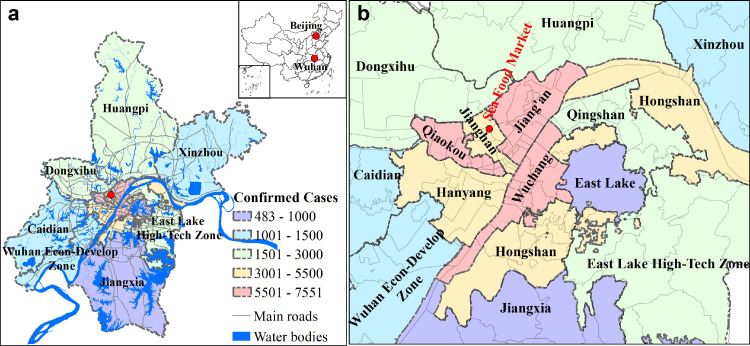
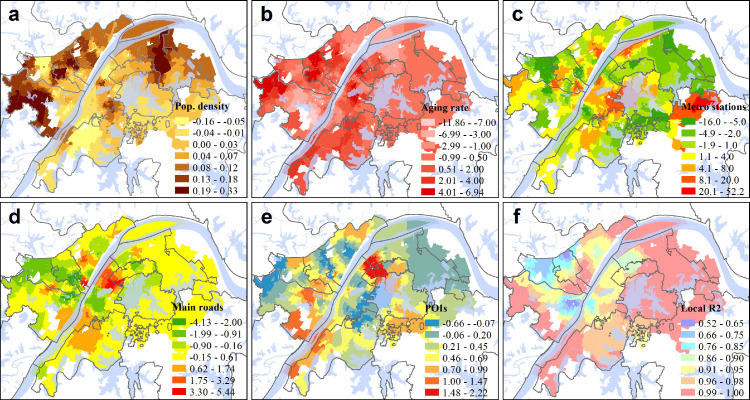
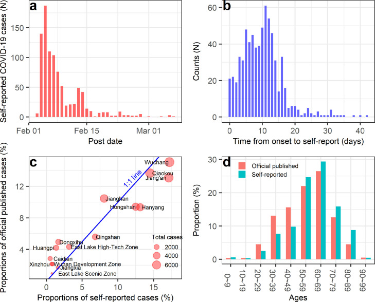
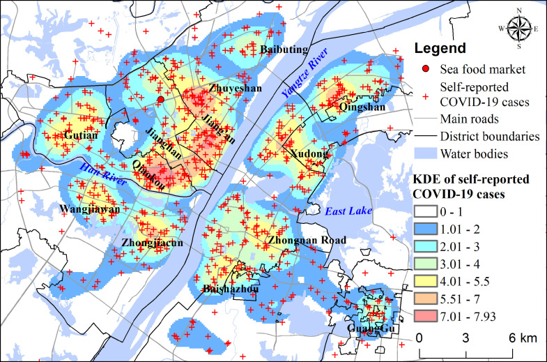
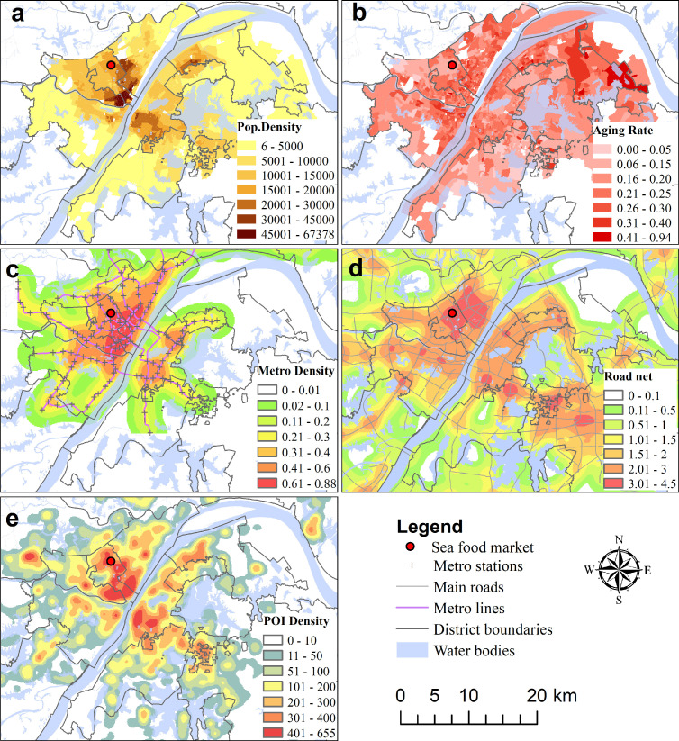
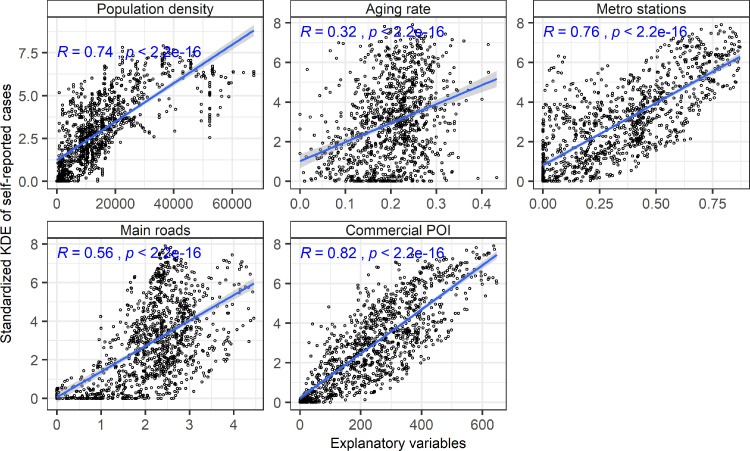
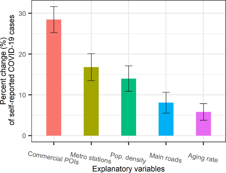
The lack of detailed COVID-19 cases at a fine spatial resolution restricts the investigation of spatial disparities of its attack rate. Here, we collected nearly one thousand self-reported cases from a social media platform during the early stage of COVID-19 epidemic in Wuhan, China. We used kernel density estimation (KDE) to explore spatial disparities of epidemic intensity and adopted geographically weighted regression (GWR) model to quantify influences of population dynamics, transportation, and social interactions on COVID-19 epidemic. Results show that self-reported COVID-19 cases concentrated in commercial centers and populous residential areas. Blocks with higher population density, higher aging rate, more metro stations, more main roads, and more commercial point-of-interests (POIs) have a higher density of COVID-19 cases. These five explanatory variables explain 76% variance of self-reported cases using an OLS model. Commercial POIs have the strongest influence, which increase COVID-19 cases by 28% with one standard deviation increase. The GWR model performs better than OLS model with the adjusted of 0.96. Spatial heterogeneities of coefficients in the GWR model show that influencing factors play different roles in diverse communities. We further discussed potential implications for the healthy city and urban planning for the sustainable development of cities.

摘要

缺乏高空间分辨率的详细新冠疫情病例数据,限制了对其感染率空间差异的调查。在此,我们在中国武汉新冠疫情早期阶段,从一个社交媒体平台收集了近一千例自我报告病例。我们使用核密度估计(KDE)来探究疫情强度的空间差异,并采用地理加权回归(GWR)模型来量化人口动态、交通和社会互动对新冠疫情的影响。结果表明,自我报告的新冠病例集中在商业中心和人口密集的居民区。人口密度较高、老龄化率较高、地铁站较多、主干道较多以及商业兴趣点(POI)较多的街区,新冠病例密度较高。使用普通最小二乘法(OLS)模型,这五个解释变量解释了自我报告病例76%的方差。商业POI的影响最强,标准差每增加一个单位,新冠病例增加28%。GWR模型的表现优于OLS模型,调整后的 为0.96。GWR模型中系数的空间异质性表明,影响因素在不同社区发挥着不同作用。我们进一步讨论了对健康城市和城市规划以实现城市可持续发展的潜在影响。

https://cdn.ncbi.nlm.nih.gov/pmc/blobs/d771/8545724/89a582495add/gr7_lrg.jpg
https://cdn.ncbi.nlm.nih.gov/pmc/blobs/d771/8545724/9a1d4431396d/gr1_lrg.jpg
https://cdn.ncbi.nlm.nih.gov/pmc/blobs/d771/8545724/f53c1089ae1d/gr2_lrg.jpg
https://cdn.ncbi.nlm.nih.gov/pmc/blobs/d771/8545724/d585fc7b1d3c/gr3_lrg.jpg
https://cdn.ncbi.nlm.nih.gov/pmc/blobs/d771/8545724/a875380ecf47/gr4_lrg.jpg
https://cdn.ncbi.nlm.nih.gov/pmc/blobs/d771/8545724/0f0a9d405327/gr5_lrg.jpg
https://cdn.ncbi.nlm.nih.gov/pmc/blobs/d771/8545724/eadf5b4b2197/gr6_lrg.jpg
https://cdn.ncbi.nlm.nih.gov/pmc/blobs/d771/8545724/89a582495add/gr7_lrg.jpg

相似文献

1
Spatial disparities of self-reported COVID-19 cases and influencing factors in Wuhan, China.中国武汉自我报告的新冠肺炎病例的空间差异及影响因素
Sustain Cities Soc. 2022 Jan;76:103485. doi: 10.1016/j.scs.2021.103485. Epub 2021 Oct 25.
2
Associating COVID-19 Severity with Urban Factors: A Case Study of Wuhan.将 COVID-19 严重程度与城市因素相关联:以武汉为例的研究。
Int J Environ Res Public Health. 2020 Sep 15;17(18):6712. doi: 10.3390/ijerph17186712.
3
[Spatial-temporal evolution of ecological land and influence factors in Wuhan urban agglome-ration based on geographically weighted regression model].基于地理加权回归模型的武汉城市群生态用地时空演变及影响因素
Ying Yong Sheng Tai Xue Bao. 2020 Mar;31(3):987-998. doi: 10.13287/j.1001-9332.202003.016.
4
Local spatial variations analysis of smear-positive tuberculosis in Xinjiang using Geographically Weighted Regression model.基于地理加权回归模型的新疆涂阳肺结核局部空间变异分析
BMC Public Health. 2016 Oct 6;16(1):1058. doi: 10.1186/s12889-016-3723-4.
5
Urban Road Network Expansion and Its Driving Variables: A Case Study of Nanjing City.城市路网扩张及其驱动变量:以南京市为例。
Int J Environ Res Public Health. 2019 Jun 30;16(13):2318. doi: 10.3390/ijerph16132318.
6
Spatial Prediction of COVID-19 in China Based on Machine Learning Algorithms and Geographically Weighted Regression.基于机器学习算法和地理加权回归的中国 COVID-19 空间预测。
Comput Math Methods Med. 2021 Oct 13;2021:7196492. doi: 10.1155/2021/7196492. eCollection 2021.
7
Global and Geographically and Temporally Weighted Regression Models for Modeling PM in Heilongjiang, China from 2015 to 2018.中国黑龙江省 2015-2018 年 PM 时空地理加权回归模型研究
Int J Environ Res Public Health. 2019 Dec 14;16(24):5107. doi: 10.3390/ijerph16245107.
8
Association of built environment attributes with the spread of COVID-19 at its initial stage in China.中国新冠疫情初期建筑环境属性与疫情传播的关联
Sustain Cities Soc. 2021 Apr;67:102752. doi: 10.1016/j.scs.2021.102752. Epub 2021 Feb 3.
9
Spatial and Social Media Data Analytics of Housing Prices in Shenzhen, China.中国深圳房价的空间和社交媒体数据分析。
PLoS One. 2016 Oct 26;11(10):e0164553. doi: 10.1371/journal.pone.0164553. eCollection 2016.
10
Ingestion of GNSS-Derived ZTD and PWV for Spatial Interpolation of PM Concentration in Central and Southern China.利用 GNSS 反演的天顶延迟和 PWV 对中国中南部 PM 浓度进行空间插值。
Int J Environ Res Public Health. 2021 Jul 27;18(15):7931. doi: 10.3390/ijerph18157931.

引用本文的文献

1
Potential physical distance in the open urban grey space of city counties in Poland and COVID-19 cases and deaths throughout the pandemic.波兰城市县开放城市灰色空间中的潜在物理距离与整个疫情期间的新冠病例及死亡情况。
Arch Public Health. 2025 Mar 25;83(1):80. doi: 10.1186/s13690-025-01563-x.
2
Temporal and Spatial Effects of Extreme Drought Events on Human Epidemics over Ancient China in 1784-1787 CE.公元1784 - 1787年极端干旱事件对中国古代人类流行病的时空影响
Environ Health. 2025 Mar 11;24(1):8. doi: 10.1186/s12940-025-01163-w.
3
Spatial co-location patterns between early COVID-19 risk and urban facilities: a case study of Wuhan, China.

本文引用的文献

1
Lockdown induced night-time light dynamics during the COVID-19 epidemic in global megacities.新冠疫情期间全球特大城市因封锁导致的夜间灯光动态变化
Int J Appl Earth Obs Geoinf. 2021 Oct;102:102421. doi: 10.1016/j.jag.2021.102421. Epub 2021 Jun 30.
2
The Epidemiological Characteristics of an Outbreak of 2019 Novel Coronavirus Diseases (COVID-19) - China, 2020.2019新型冠状病毒病(COVID-19)疫情的流行病学特征 - 中国,2020年
China CDC Wkly. 2020 Feb 21;2(8):113-122.
3
Exploring the nexus between social vulnerability, built environment, and the prevalence of COVID-19: A case study of Chicago.
早期 COVID-19 风险与城市设施的空间共定位模式:以中国武汉为例。
Front Public Health. 2024 Jan 4;11:1293888. doi: 10.3389/fpubh.2023.1293888. eCollection 2023.
4
Spatial impacts of the intercity flow of long stay international visitors based on mobile phone data in Yangtze River Delta, China.基于手机数据的中国长三角地区长住国际游客城际流动的空间影响。
PLoS One. 2023 Sep 7;18(9):e0290758. doi: 10.1371/journal.pone.0290758. eCollection 2023.
5
Spatiotemporal Patterns of the Omicron Wave of COVID-19 in the United States.美国新冠疫情奥密克戎毒株浪潮的时空模式
Trop Med Infect Dis. 2023 Jun 30;8(7):349. doi: 10.3390/tropicalmed8070349.
6
Dataset for developing optimal headway-based bus dispatching strategy during epidemic outbreaks.用于制定疫情爆发期间基于最佳车间距的公交调度策略的数据集。
Data Brief. 2023 Jul 20;49:109423. doi: 10.1016/j.dib.2023.109423. eCollection 2023 Aug.
7
Tokyo's COVID-19: An urban perspective on factors influencing infection rates in a global city.东京的新冠疫情:从城市视角看影响全球城市感染率的因素
Sustain Cities Soc. 2023 Oct;97:104743. doi: 10.1016/j.scs.2023.104743. Epub 2023 Jun 28.
8
Pandemic vulnerability index of US cities: A hybrid knowledge-based and data-driven approach.美国城市的大流行脆弱性指数:一种基于知识与数据驱动的混合方法。
Sustain Cities Soc. 2023 Aug;95:104570. doi: 10.1016/j.scs.2023.104570. Epub 2023 Apr 11.
9
Are the epidemic prevention facilities effective? How cities should choose epidemic prevention facilities: Taking Wuhan as an example.防疫设施是否有效?城市应如何选择防疫设施:以武汉市为例。
Front Public Health. 2023 Mar 30;11:1125301. doi: 10.3389/fpubh.2023.1125301. eCollection 2023.
10
Integration of Moran's I, geographically weighted regression (GWR), and ordinary least square (OLS) models in spatiotemporal modeling of COVID-19 outbreak in Qom and Mazandaran Provinces, Iran.莫兰指数(Moran's I)、地理加权回归(GWR)和普通最小二乘法(OLS)模型在伊朗库姆省和马赞德兰省新冠肺炎疫情时空建模中的整合
Model Earth Syst Environ. 2023 Feb 15:1-15. doi: 10.1007/s40808-023-01729-y.
探索社会脆弱性、建成环境与新冠病毒病患病率之间的联系:以芝加哥为例
Sustain Cities Soc. 2021 Dec;75:103261. doi: 10.1016/j.scs.2021.103261. Epub 2021 Aug 20.
4
The impacts of the built environment on the incidence rate of COVID-19: A case study of King County, Washington.建筑环境对新冠病毒疾病发病率的影响:以华盛顿州金县为例
Sustain Cities Soc. 2021 Nov;74:103144. doi: 10.1016/j.scs.2021.103144. Epub 2021 Jul 10.
5
COVID-19, the Built Environment, and Health.新型冠状病毒肺炎(COVID-19)、建筑环境与健康
Environ Health Perspect. 2021 Jul;129(7):75001. doi: 10.1289/EHP8888. Epub 2021 Jul 21.
6
The density paradox: Are densely-populated regions more vulnerable to Covid-19?密度悖论:人口密集地区更容易受到新冠病毒的影响吗?
Int J Health Plann Manage. 2021 Sep;36(5):1575-1588. doi: 10.1002/hpm.3189. Epub 2021 May 18.
7
Socioeconomic status determines COVID-19 incidence and related mortality in Santiago, Chile.社会经济地位决定智利圣地亚哥的 COVID-19 发病率和相关死亡率。
Science. 2021 May 28;372(6545). doi: 10.1126/science.abg5298. Epub 2021 Apr 27.
8
Exploring spatiotemporal effects of the driving factors on COVID-19 incidences in the contiguous United States.探究驱动因素对美国本土COVID-19发病率的时空影响。
Sustain Cities Soc. 2021 May;68:102784. doi: 10.1016/j.scs.2021.102784. Epub 2021 Feb 19.
9
Association of built environment attributes with the spread of COVID-19 at its initial stage in China.中国新冠疫情初期建筑环境属性与疫情传播的关联
Sustain Cities Soc. 2021 Apr;67:102752. doi: 10.1016/j.scs.2021.102752. Epub 2021 Feb 3.
10
The COVID-19 pandemic: Impacts on cities and major lessons for urban planning, design, and management.新型冠状病毒肺炎疫情:对城市的影响及对城市规划、设计和管理的主要启示。
Sci Total Environ. 2020 Dec 20;749:142391. doi: 10.1016/j.scitotenv.2020.142391. Epub 2020 Sep 18.