• 文献检索
  • 文档翻译
  • 深度研究
  • 学术资讯
  • Suppr Zotero 插件Zotero 插件
  • 邀请有礼
  • 套餐&价格
  • 历史记录
应用&插件
Suppr Zotero 插件Zotero 插件浏览器插件Mac 客户端Windows 客户端微信小程序
定价
高级版会员购买积分包购买API积分包
服务
文献检索文档翻译深度研究API 文档MCP 服务
关于我们
关于 Suppr公司介绍联系我们用户协议隐私条款
关注我们

Suppr 超能文献

核心技术专利:CN118964589B侵权必究
粤ICP备2023148730 号-1Suppr @ 2026

文献检索

告别复杂PubMed语法,用中文像聊天一样搜索,搜遍4000万医学文献。AI智能推荐,让科研检索更轻松。

立即免费搜索

文件翻译

保留排版,准确专业,支持PDF/Word/PPT等文件格式,支持 12+语言互译。

免费翻译文档

深度研究

AI帮你快速写综述,25分钟生成高质量综述,智能提取关键信息,辅助科研写作。

立即免费体验

利用哨兵 - 2A 多光谱成像仪、陆地卫星 7 增强型专题绘图仪和陆地卫星 8 运营陆地成像仪对森林叶面积指数预测中的工作流特征选择进行评估。

Assessment of Workflow Feature Selection on Forest LAI Prediction with Sentinel-2A MSI, Landsat 7 ETM+ and Landsat 8 OLI.

作者信息

Brede Benjamin, Verrelst Jochem, Gastellu-Etchegorry Jean-Philippe, Clevers Jan G P W, Goudzwaard Leo, den Ouden Jan, Verbesselt Jan, Herold Martin

机构信息

Laboratory of Geo-Information Science and Remote Sensing, Wageningen University & Research, Droevendaalsesteeg 3, 6708 PB Wageningen, The Netherlands.

Image Processing Laboratory (IPL), Parc Científic, Universitat de València, 46980 Paterna, València, Spain.

出版信息

Remote Sens (Basel). 2020 Mar 12;12(6):915. doi: 10.3390/rs12060915.

DOI:10.3390/rs12060915
PMID:36081763
原文链接:https://pmc.ncbi.nlm.nih.gov/articles/PMC7613362/
Abstract

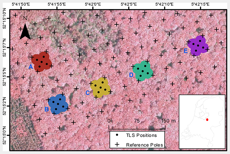
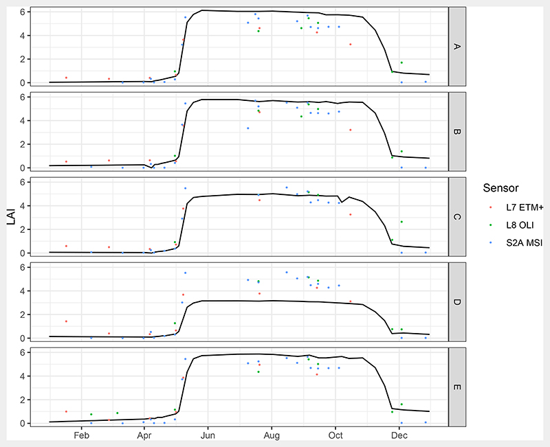
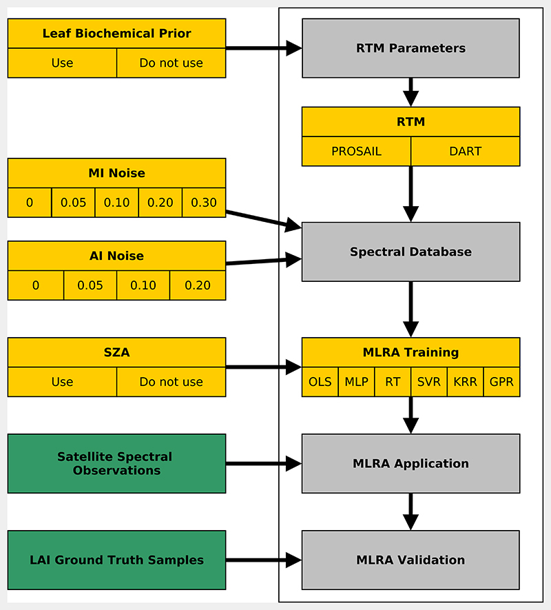
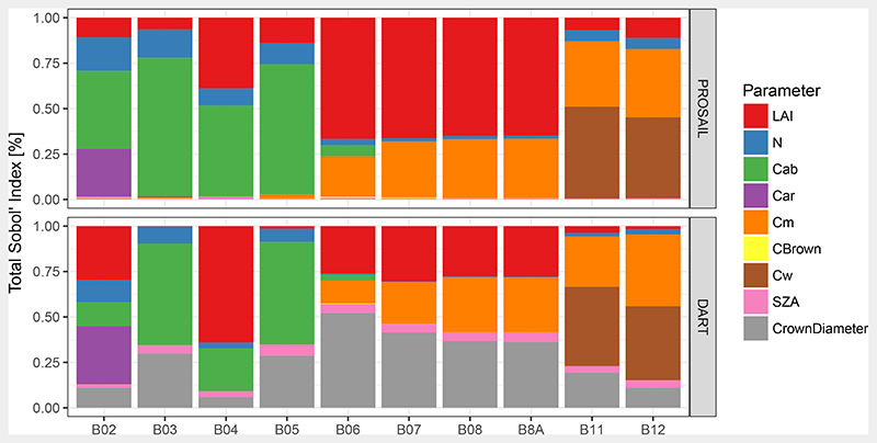
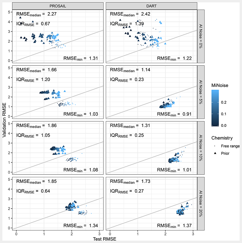
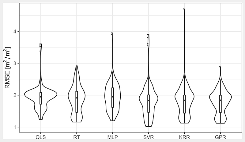
The European Space Agency (ESA)'s Sentinel-2A (S2A) mission is providing time series that allow the characterisation of dynamic vegetation, especially when combined with the National Aeronautics and Space Administration (NASA)/United States Geological Survey (USGS) Landsat 7 (L7) and Landsat 8 (L8) missions. Hybrid retrieval workflows combining non-parametric Machine Learning Regression Algorithms (MLRAs) and vegetation Radiative Transfer Models (RTMs) were proposed as fast and accurate methods to infer biophysical parameters such as Leaf Area Index (LAI) from these data streams. However, the exact design of optimal retrieval workflows is rarely discussed. In this study, the impact of five retrieval workflow features on LAI prediction performance of MultiSpectral Instrument (MSI), Enhanced Thematic Mapper Plus (ETM+) and Operational Land Imager (OLI) observations was analysed over a Dutch beech forest site for a one-year period. The retrieval workflow features were the (1) addition of prior knowledge of leaf chemistry (two alternatives), (2) the choice of RTM (two alternatives), (3) the addition of Gaussian noise to RTM produced training data (four and five alternatives), (4) possibility of using Sun Zenith Angle (SZA) as an additional MLRA training feature (two alternatives), and (5) the choice of MLRA (six alternatives). The features were varied in a full grid resulting in 960 inversion models in order to find the overall impact on performance as well as possible interactions among the features. A combination of a Terrestrial Laser Scanning (TLS) time series with litter-trap derived LAI served as independent validation. The addition of absolute noise had the most significant impact on prediction performance. It improved the median prediction Root Mean Square Error (RMSE) by 1.08 m m when 5 % noise was added compared to inversions with 0 % absolute noise. The choice of the MLRA was second most important in terms of median prediction performance, which differed by 0.52 m m between the best and worst model. The best inversion model achieved an RMSE of 0.91 m m and explained 84.9% of the variance of the reference time series. The results underline the need to explicitly describe the used noise model in future studies. Similar studies should be conducted in other study areas, both forest and crop systems, in order to test the noise model as an integral part of hybrid retrieval workflows.

摘要

欧洲航天局(ESA)的哨兵 - 2A(S2A)任务正在提供时间序列数据,这些数据有助于对动态植被进行特征描述,特别是当与美国国家航空航天局(NASA)/美国地质调查局(USGS)的陆地卫星7(L7)和陆地卫星8(L8)任务的数据相结合时。有人提出将非参数机器学习回归算法(MLRAs)和植被辐射传输模型(RTMs)相结合的混合反演工作流程,作为从这些数据流中快速准确地推断诸如叶面积指数(LAI)等生物物理参数的方法。然而,很少有人讨论最优反演工作流程的确切设计。在本研究中,在荷兰的一片山毛榉林地上,分析了为期一年的五种反演工作流程特征对多光谱仪器(MSI)、增强型专题绘图仪Plus(ETM +)和业务陆地成像仪(OLI)观测的LAI预测性能的影响。反演工作流程特征包括:(1)添加叶片化学的先验知识(两种选择);(2)RTM的选择(两种选择);(3)向RTM生成的训练数据中添加高斯噪声(四种和五种选择);(4)将太阳天顶角(SZA)用作额外的MLRA训练特征的可能性(两种选择);(5)MLRA的选择(六种选择)。这些特征在一个全网格中变化,从而产生960个反演模型,以便找出对性能的总体影响以及各特征之间可能的相互作用。将地面激光扫描(TLS)时间序列与通过凋落物收集器得出的LAI相结合,作为独立验证。添加绝对噪声对预测性能的影响最为显著。与添加0%绝对噪声的反演相比,添加5%噪声时,预测均方根误差(RMSE)的中位数提高了1.08 m²。就预测性能中位数而言,MLRA的选择是第二重要的,最佳模型和最差模型之间相差0.52 m²。最佳反演模型的RMSE为0.91 m²,解释了参考时间序列方差的84.9%。结果强调了在未来研究中明确描述所使用噪声模型的必要性。应该在其他研究区域,包括森林和作物系统中进行类似研究,以测试噪声模型作为混合反演工作流程不可或缺的一部分的情况。

https://cdn.ncbi.nlm.nih.gov/pmc/blobs/02a9/7613362/197761542e2c/EMS152651-f011.jpg
https://cdn.ncbi.nlm.nih.gov/pmc/blobs/02a9/7613362/c1bbadf353ec/EMS152651-f001.jpg
https://cdn.ncbi.nlm.nih.gov/pmc/blobs/02a9/7613362/4f73c4f90f55/EMS152651-f002.jpg
https://cdn.ncbi.nlm.nih.gov/pmc/blobs/02a9/7613362/46d66eab9111/EMS152651-f003.jpg
https://cdn.ncbi.nlm.nih.gov/pmc/blobs/02a9/7613362/926812642050/EMS152651-f004.jpg
https://cdn.ncbi.nlm.nih.gov/pmc/blobs/02a9/7613362/84358b7462c7/EMS152651-f005.jpg
https://cdn.ncbi.nlm.nih.gov/pmc/blobs/02a9/7613362/1a9ef854eba1/EMS152651-f006.jpg
https://cdn.ncbi.nlm.nih.gov/pmc/blobs/02a9/7613362/d04b55dd9b46/EMS152651-f007.jpg
https://cdn.ncbi.nlm.nih.gov/pmc/blobs/02a9/7613362/1259b121d1a8/EMS152651-f008.jpg
https://cdn.ncbi.nlm.nih.gov/pmc/blobs/02a9/7613362/4dd98c916aa9/EMS152651-f009.jpg
https://cdn.ncbi.nlm.nih.gov/pmc/blobs/02a9/7613362/149d0408c5b7/EMS152651-f010.jpg
https://cdn.ncbi.nlm.nih.gov/pmc/blobs/02a9/7613362/197761542e2c/EMS152651-f011.jpg

相似文献

1
Assessment of Workflow Feature Selection on Forest LAI Prediction with Sentinel-2A MSI, Landsat 7 ETM+ and Landsat 8 OLI.利用哨兵 - 2A 多光谱成像仪、陆地卫星 7 增强型专题绘图仪和陆地卫星 8 运营陆地成像仪对森林叶面积指数预测中的工作流特征选择进行评估。
Remote Sens (Basel). 2020 Mar 12;12(6):915. doi: 10.3390/rs12060915.
2
Gaussian processes retrieval of crop traits in Google Earth Engine based on Sentinel-2 top-of-atmosphere data.基于哨兵 - 2 大气层顶数据,利用高斯过程在谷歌地球引擎中检索作物性状。
Remote Sens Environ. 2022 Mar 4;273:112958. doi: 10.1016/j.rse.2022.112958. eCollection 2022 May.
3
Estimation of leaf area index using PROSAIL based LUT inversion, MLRA-GPR and empirical models: Case study of tropical deciduous forest plantation, North India.基于PROSAIL查找表反演、多元线性回归-高斯过程回归和经验模型的叶面积指数估算:印度北部热带落叶人工林案例研究
Int J Appl Earth Obs Geoinf. 2020 Apr;86:102027. doi: 10.1016/j.jag.2019.102027.
4
Quantifying vegetation biophysical variables from the Sentinel-3/FLEX tandem mission: Evaluation of the synergy of OLCI and FLORIS data sources.从哨兵-3/荧光植被探测器联合任务中量化植被生物物理变量:对海洋和陆地颜色仪器(OLCI)与荧光光谱仪(FLORIS)数据源协同作用的评估
Remote Sens Environ. 2020 Dec 15;251. doi: 10.1016/j.rse.2020.112101.
5
Comparative Analysis of EO-1 ALI and Hyperion, and Landsat ETM+ Data for Mapping Forest Crown Closure and Leaf Area Index.用于绘制森林郁闭度和叶面积指数的EO - 1 ALI、Hyperion及陆地卫星ETM + 数据的对比分析
Sensors (Basel). 2008 Jun 6;8(6):3744-3766. doi: 10.3390/s8063744.
6
Estimation of Soil Organic Carbon Content in the Ebinur Lake Wetland, Xinjiang, China, Based on Multisource Remote Sensing Data and Ensemble Learning Algorithms.基于多源遥感数据和集成学习算法的新疆艾比湖湿地土壤有机碳含量估算。
Sensors (Basel). 2022 Mar 31;22(7):2685. doi: 10.3390/s22072685.
7
Multi-Season Phenology Mapping of Nile Delta Croplands Using Time Series of Sentinel-2 and Landsat 8 Green LAI.利用哨兵-2和陆地卫星8号绿色叶面积指数时间序列绘制尼罗河三角洲农田的多季节物候图
Remote Sens (Basel). 2022 Apr 9;14(8):1812. doi: 10.3390/rs14081812.
8
[Retrieval of leaf area index of moso bamboo forest with Landsat Thematic Mapper image based on PROSAIL canopy radiative transfer model].基于PROSAIL冠层辐射传输模型的Landsat专题制图仪影像反演毛竹林叶面积指数
Ying Yong Sheng Tai Xue Bao. 2013 Aug;24(8):2248-56.
9
Quantifying Fundamental Vegetation Traits over Europe Using the Sentinel-3 OLCI Catalogue in Google Earth Engine.利用谷歌地球引擎中的哨兵-3 OLCI目录对欧洲的基本植被特征进行量化。
Remote Sens (Basel). 2022 Mar 10;14(6):1347. doi: 10.3390/rs14061347.
10
Characterization of Landsat-7 to Landsat-8 reflective wavelength and normalized difference vegetation index continuity.陆地卫星7号至陆地卫星8号反射波长及归一化植被指数连续性的特征分析
Remote Sens Environ. 2016 Jan 12;Volume 185(Iss 1):57-70. doi: 10.1016/j.rse.2015.12.024.

引用本文的文献

1
Retrieval of carbon content and biomass from hyperspectral imagery over cultivated areas.从耕地的高光谱图像中反演碳含量和生物量。
ISPRS J Photogramm Remote Sens. 2022 Nov;193:104-114. doi: 10.1016/j.isprsjprs.2022.09.003.
2
Quantifying mangrove leaf area index from Sentinel-2 imagery using hybrid models and active learning.使用混合模型和主动学习从哨兵-2影像中量化红树林叶面积指数。
Int J Remote Sens. 2022 Aug 18;43(15-16):5636-5657. doi: 10.1080/01431161.2021.2024912. Epub 2022 Mar 25.
3
Mapping landscape canopy nitrogen content from space using PRISMA data.

本文引用的文献

1
Atmospheric Correction Inter-comparison eXercise.大气校正相互比较实验
Remote Sens (Basel). 2018 Feb;10(2):352. doi: 10.3390/rs10020352. Epub 2018 Feb 24.
2
Amazon forests maintain consistent canopy structure and greenness during the dry season.亚马逊森林在旱季保持稳定的冠层结构和绿色度。
Nature. 2014 Feb 13;506(7487):221-4. doi: 10.1038/nature13006. Epub 2014 Feb 5.
3
Evaluation of Sentinel-2 red-edge bands for empirical estimation of green LAI and chlorophyll content.评价 Sentinel-2 红色边缘波段对绿色 LAI 和叶绿素含量的经验估计。
利用PRISMA数据从太空绘制景观冠层氮含量图。
ISPRS J Photogramm Remote Sens. 2021 Aug;178:382-395. doi: 10.1016/j.isprsjprs.2021.06.017. Epub 2021 Jul 15.
4
Seasonal Mapping of Irrigated Winter Wheat Traits in Argentina with a Hybrid Retrieval Workflow Using Sentinel-2 Imagery.利用哨兵-2影像通过混合反演工作流程对阿根廷灌溉冬小麦性状进行季节性测绘
Remote Sens (Basel). 2022 Sep 10;14(18):4531. doi: 10.3390/rs14184531.
5
Estimating soil moisture content under grassland with hyperspectral data using radiative transfer modelling and machine learning.利用辐射传输模型和机器学习,通过高光谱数据估算草原下的土壤湿度含量。
Int J Appl Earth Obs Geoinf. 2022 May 18;110:102817. doi: 10.1016/j.jag.2022.102817. eCollection 2022 Jun.
6
Retrieval of aboveground crop nitrogen content with a hybrid machine learning method.利用混合机器学习方法反演地上作物氮含量
Int J Appl Earth Obs Geoinf. 2020 Oct 1;92:102174. doi: 10.1016/j.jag.2020.102174. eCollection 2020 Oct.
7
Intelligent Sampling for Vegetation Nitrogen Mapping Based on Hybrid Machine Learning Algorithms.基于混合机器学习算法的植被氮素制图智能采样
IEEE Geosci Remote Sens Lett. 2021 Dec;18(12):2038-2042. doi: 10.1109/lgrs.2020.3014676.
8
Quantifying vegetation biophysical variables from the Sentinel-3/FLEX tandem mission: Evaluation of the synergy of OLCI and FLORIS data sources.从哨兵-3/荧光植被探测器联合任务中量化植被生物物理变量:对海洋和陆地颜色仪器(OLCI)与荧光光谱仪(FLORIS)数据源协同作用的评估
Remote Sens Environ. 2020 Dec 15;251. doi: 10.1016/j.rse.2020.112101.
9
Top-of-Atmosphere Retrieval of Multiple Crop Traits Using Variational Heteroscedastic Gaussian Processes within a Hybrid Workflow.在混合工作流程中使用变分异方差高斯过程对多种作物性状进行大气顶层反演
Remote Sens (Basel). 2021 Apr 20;13(8):1589. doi: 10.3390/rs13081589.
10
Assessing Non-Photosynthetic Cropland Biomass from Spaceborne Hyperspectral Imagery.利用星载高光谱影像评估非光合农田生物量
Remote Sens (Basel). 2021 Nov 21;13(22):4711. doi: 10.3390/rs13224711.
Sensors (Basel). 2011;11(7):7063-81. doi: 10.3390/s110707063. Epub 2011 Jul 8.
4
Terrestrial gross carbon dioxide uptake: global distribution and covariation with climate.陆地总二氧化碳吸收:全球分布及与气候的相互关系。
Science. 2010 Aug 13;329(5993):834-8. doi: 10.1126/science.1184984. Epub 2010 Jul 5.
5
Estimating forest LAI profiles and structural parameters using a ground-based laser called 'Echidna'.使用名为“针鼹”的地面激光雷达估算森林叶面积指数剖面和结构参数。
Tree Physiol. 2009 Feb;29(2):171-81. doi: 10.1093/treephys/tpn022. Epub 2008 Dec 5.