Xu Jing
School of Architecture and Engineering, Huangshan University, Huangshan, China.
Sci Rep. 2023 Sep 1;13(1):14400. doi: 10.1038/s41598-023-41507-5.
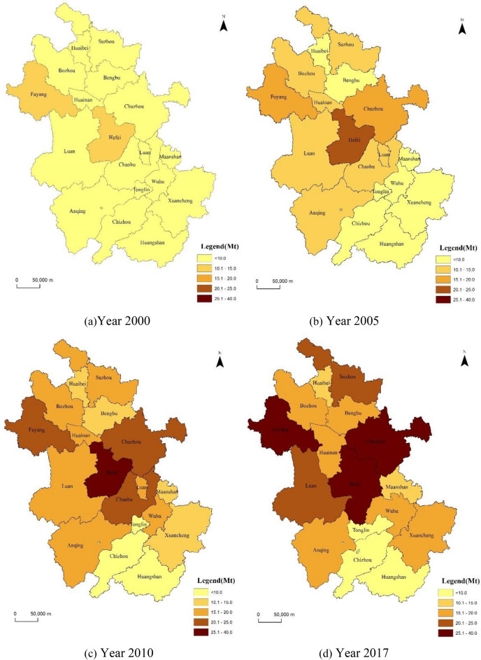
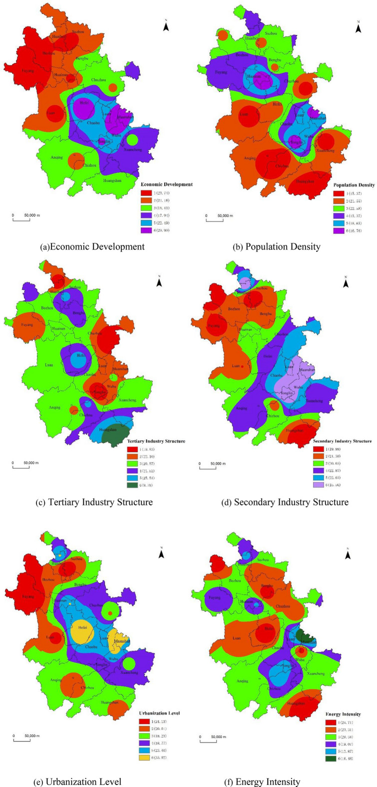
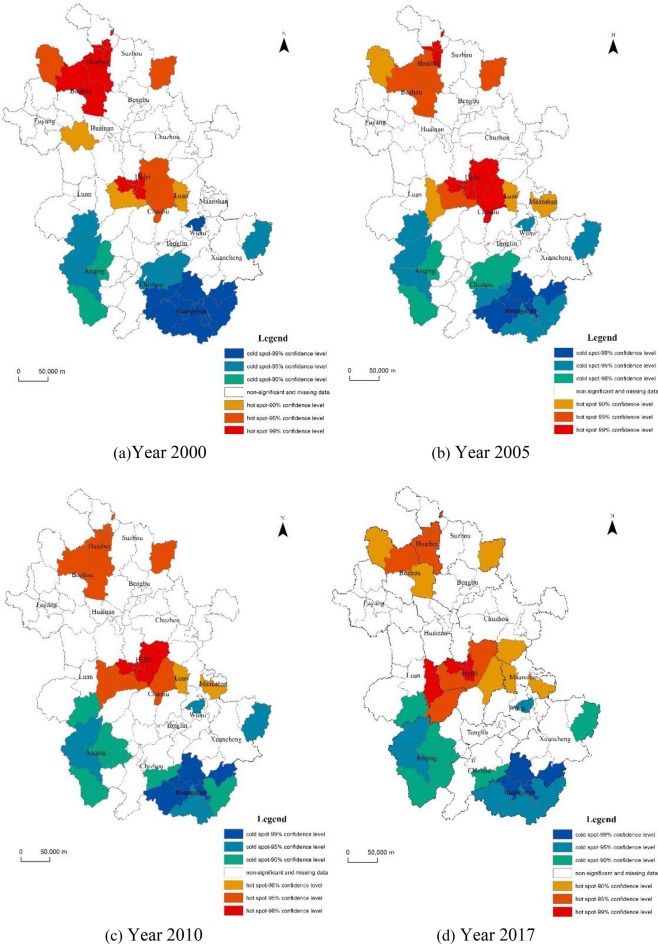
Carbon emission is related to global ecological security, and economic development inevitably leads to an increase in carbon emission. In recent years, as a rapidly developing province in China's economy, Anhui Province has experienced significant differences in the spatiotemporal distribution of carbon emission in different regions due to differences in development foundation, urbanization level, population size, industrial structure, etc., providing representative empirical cases for research. Based on the carbon emission data of Anhui Province before the COVID-19, this study used exploratory spatial data analysis method and Geodetector to analyze the spatial and temporal distribution characteristics and drivers of carbon emission in Anhui Province. The study found that (1) the spatial differentiation and spatial correlation of carbon emission in Anhui Province are significant, At the beginning, it shows the characteristics of "high north and low south" and "high west and low east", and then the "core-edge" structure of carbon emission becomes obvious. Carbon emission hotspot areas increase and then decrease, mainly in Hefei, Fuyang and Chuzhou City, etc. The coldspot areas are mainly located in the southern and western mountainous areas, and the degree of aggregation is decreasing year by year. (3) The level of urbanization, economic development and population size are the main driving factors of the spatial variation of carbon emissions, while the industrial structure has the least influence. And most factors produce nonlinear enhancement when spatially superimposed with other factors. (4) The high value areas of economic development, population density, secondary industry structure, and energy intensity are all at high levels of carbon emission, and a combination of factors leads to the creation of high risk areas for carbon emission. The study provides a basis for reducing carbon emission in the next stage of Anhui Province, focusing on key carbon emission areas, and sustainable development.
碳排放关系到全球生态安全,而经济发展不可避免地导致碳排放增加。近年来,安徽省作为中国经济快速发展的省份,由于发展基础、城市化水平、人口规模、产业结构等方面的差异,不同地区的碳排放时空分布存在显著差异,为研究提供了具有代表性的实证案例。基于新冠疫情之前安徽省的碳排放数据,本研究采用探索性空间数据分析方法和地理探测器,对安徽省碳排放的时空分布特征及驱动因素进行了分析。研究发现:(1)安徽省碳排放的空间分异和空间相关性显著,初期呈现“北高南低”“西高东低”的特征,随后碳排放的“核心—边缘”结构明显。碳排放热点区域先增加后减少,主要集中在合肥、阜阳和滁州市等地。冷点区域主要位于南部和西部山区,且集聚程度逐年降低。(3)城市化水平、经济发展和人口规模是碳排放空间变化的主要驱动因素,而产业结构的影响最小。并且多数因素在与其他因素进行空间叠加时产生非线性增强。(4)经济发展、人口密度、第二产业结构和能源强度的高值区域均处于碳排放的高水平,多种因素组合导致碳排放高风险区域的形成。该研究为安徽省下一阶段降低碳排放、聚焦重点碳排放区域以及可持续发展提供了依据。