Department of Epidemiology, Rollins School of Public Health, Emory University, Atlanta, GA, USA.
Int J Health Geogr. 2010 Jun 12;9:29. doi: 10.1186/1476-072X-9-29.
Racial residential segregation is hypothesized to affect population health by systematically patterning health-relevant exposures and opportunities according to individuals' race or income. Growing interest into the association between residential segregation and health disparities demands more rigorous appraisal of commonly used measures of segregation. Most current studies rely on census tracts as approximations of the local residential environment when calculating segregation indices of either neighborhoods or metropolitan areas. Because census tracts are arbitrary in size and shape, reliance on this geographic scale limits understanding of place-health associations. More flexible, explicitly spatial derivations of traditional segregation indices have been proposed but have not been compared with tract-derived measures in the context of health disparities studies common to social epidemiology, health demography, or medical geography. We compared segregation measured with tract-derived as well as GIS surface-density-derived indices. Measures were compared by region and population size, and segregation measures were linked to birth record to estimate the difference in association between segregation and very preterm birth. Separate analyses focus on metropolitan segregation and on neighborhood segregation.
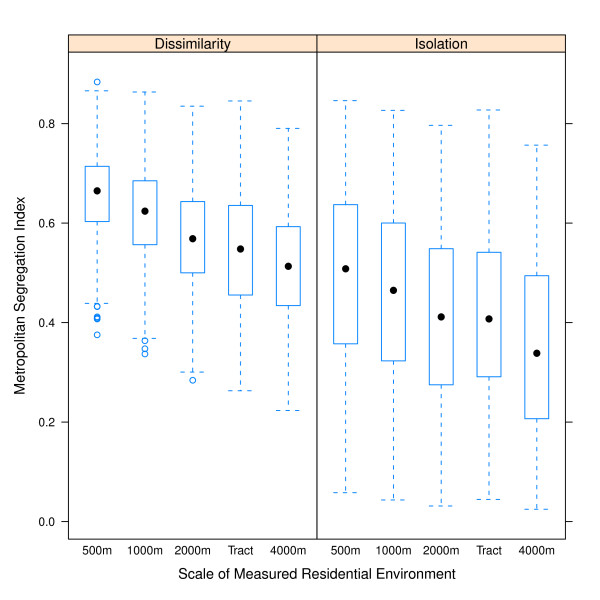
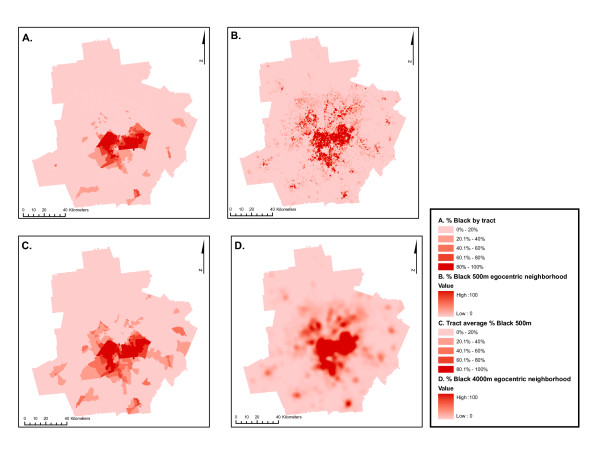
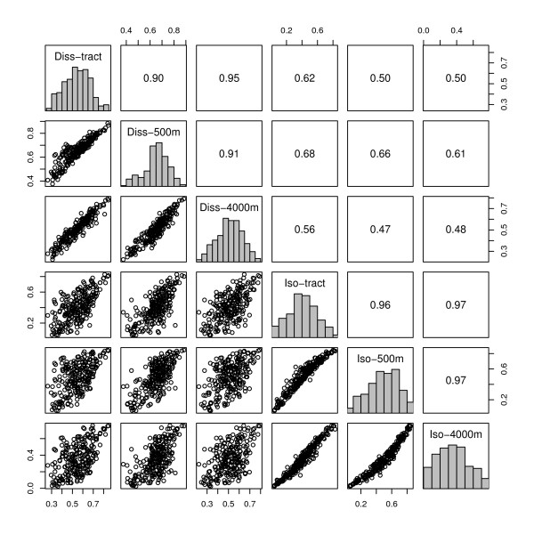
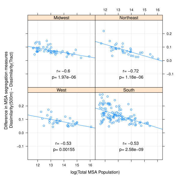
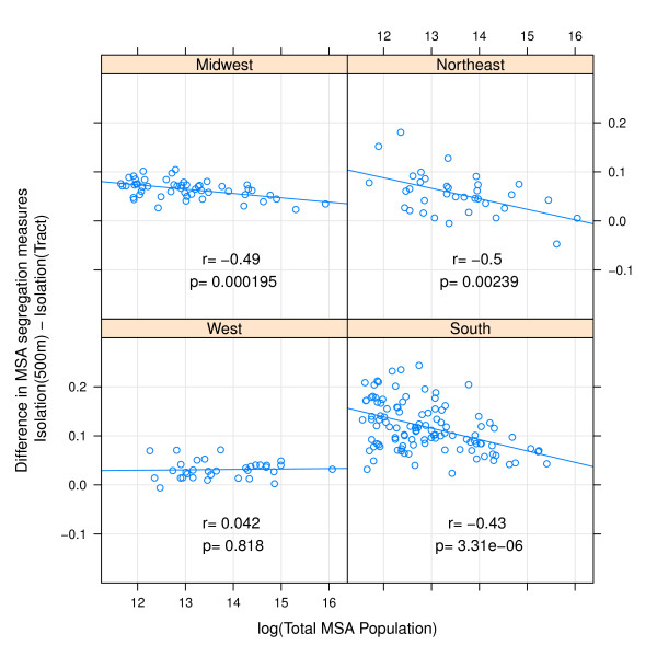
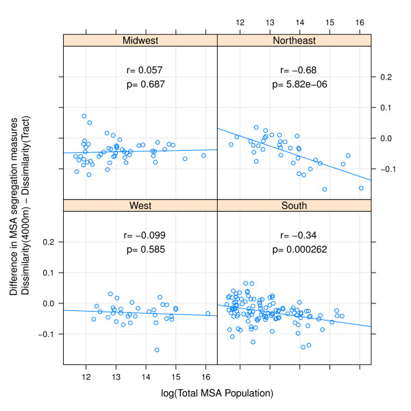
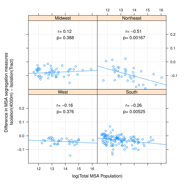
Across 231 metropolitan areas, tract-derived and surface-density-derived segregation measures are highly correlated. However overall correlation obscures important differences by region and metropolitan size. In general the discrepancy between measure types is greatest for small metropolitan areas, declining with increasing population size. Discrepancies in measures are greatest in the South, and smallest in Western metropolitan areas. Choice of segregation index changed the magnitude of the measured association between segregation and very preterm birth. For example among black women, the risk ratio for very preterm birth in metropolitan areas changed from 2.12 to 1.68 for the effect of high versus low segregation when using surface-density-derived versus tract-derived segregation indices. Variation in effect size was smaller but still present in analyses of neighborhood racial composition and very preterm birth in Atlanta neighborhoods.
Census tract-derived measures of segregation are highly correlated with recently introduced spatial segregation measures, but the residual differences among measures are not uniform for all areas. Use of surface-density-derived measures provides researchers with tools to further explore the spatial relationships between segregation and health disparities.
种族居住隔离被假设通过根据个体的种族或收入系统地塑造与健康相关的暴露和机会,从而影响人口健康。对居住隔离与健康差距之间关联的日益关注要求更严格地评估隔离的常用衡量标准。大多数当前的研究在计算邻里或大都市区的隔离指数时,依赖于普查区作为当地居住环境的近似值。由于普查区的大小和形状是任意的,因此依赖这种地理尺度限制了对地方健康关联的理解。已经提出了更灵活的、明确的传统隔离指数的空间推导,但在社会流行病学、健康人口统计学或医学地理学中常见的健康差距研究中,尚未与基于普查区的度量进行比较。我们比较了基于普查区和 GIS 表面密度推导的隔离程度。通过区域和人口规模比较了衡量标准,并将隔离措施与出生记录联系起来,以估计隔离与非常早产之间关联的差异。单独的分析侧重于大都市区的隔离和邻里的隔离。
在 231 个大都市区中,基于普查区和基于表面密度的隔离程度的衡量标准高度相关。然而,总体相关性掩盖了区域和大都市规模的重要差异。一般来说,在小的大都市区中,这两种测量类型之间的差异最大,随着人口规模的增加而下降。这种差异在南部最大,在西部大都市区最小。隔离指数的选择改变了隔离与非常早产之间测量关联的大小。例如,对于黑人女性,在使用基于表面密度的隔离程度和基于普查区的隔离程度的情况下,大都市区中非常早产的风险比从高隔离与低隔离的 2.12 变为 1.68。在亚特兰大邻里的种族构成和非常早产的分析中,虽然效应大小的差异较小,但仍然存在。
普查区派生的隔离程度衡量标准与最近引入的空间隔离程度衡量标准高度相关,但衡量标准之间的剩余差异并不适用于所有地区。使用基于表面密度的度量标准为研究人员提供了工具,可以进一步探索隔离与健康差距之间的空间关系。