Department of Infectious and Tropical Diseases, London School of Hygiene and Tropical Medicine, London, United Kingdom.
PLoS Negl Trop Dis. 2011 Feb 8;5(2):e958. doi: 10.1371/journal.pntd.0000958.
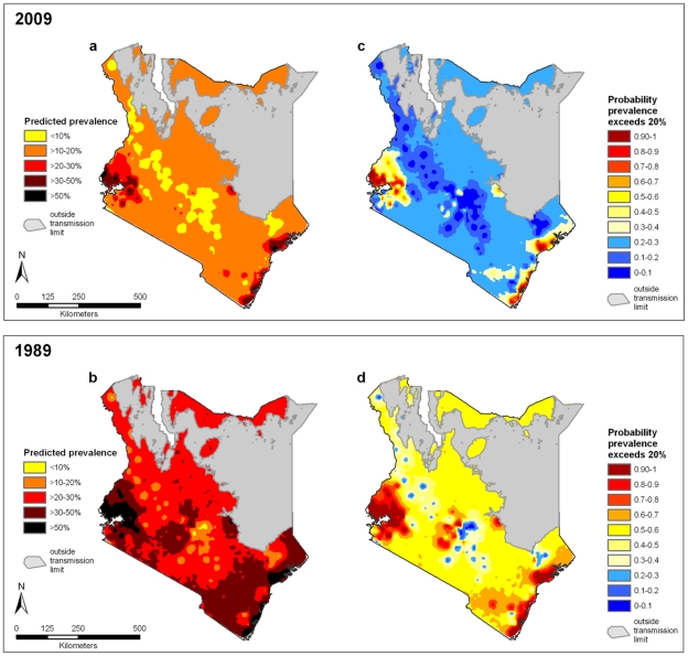
Implementation of control of parasitic diseases requires accurate, contemporary maps that provide intervention recommendations at policy-relevant spatial scales. To guide control of soil transmitted helminths (STHs), maps are required of the combined prevalence of infection, indicating where this prevalence exceeds an intervention threshold of 20%. Here we present a new approach for mapping the observed prevalence of STHs, using the example of Kenya in 2009.
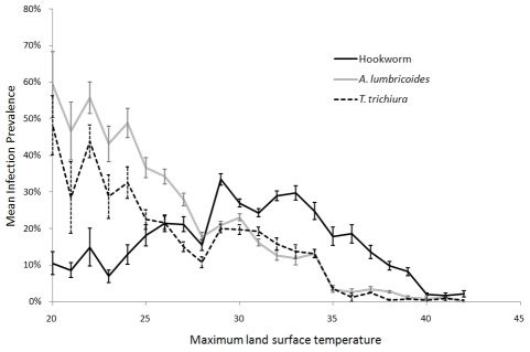
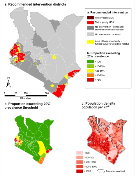
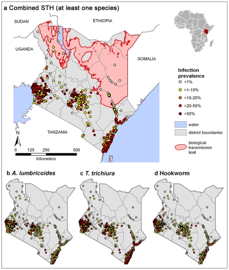
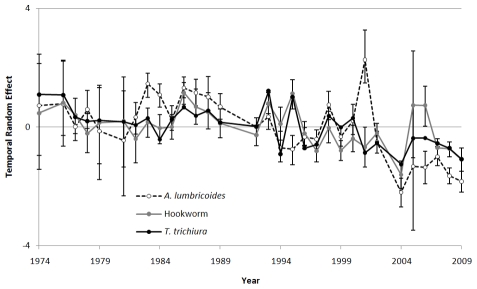
Observed prevalence data for hookworm, Ascaris lumbricoides and Trichuris trichiura were assembled for 106,370 individuals from 945 cross-sectional surveys undertaken between 1974 and 2009. Ecological and climatic covariates were extracted from high-resolution satellite data and matched to survey locations. Bayesian space-time geostatistical models were developed for each species, and were used to interpolate the probability that infection prevalence exceeded the 20% threshold across the country for both 1989 and 2009. Maps for each species were integrated to estimate combined STH prevalence using the law of total probability and incorporating a correction factor to adjust for associations between species. Population census data were combined with risk models and projected to estimate the population at risk and requiring treatment in 2009. In most areas for 2009, there was high certainty that endemicity was below the 20% threshold, with areas of endemicity ≥ 20% located around the shores of Lake Victoria and on the coast. Comparison of the predicted distributions for 1989 and 2009 show how observed STH prevalence has gradually decreased over time. The model estimated that a total of 2.8 million school-age children live in districts which warrant mass treatment.
Bayesian space-time geostatistical models can be used to reliably estimate the combined observed prevalence of STH and suggest that a quarter of Kenya's school-aged children live in areas of high prevalence and warrant mass treatment. As control is successful in reducing infection levels, updated models can be used to refine decision making in helminth control.
寄生虫病防治工作需要准确的、时效性强的地图,为相关政策提供具有实际意义的空间尺度干预建议。为了指导土壤传播性蠕虫(STHs)的防治工作,需要绘制感染综合流行率地图,以便显示出流行率超过 20%干预阈值的地区。本研究以肯尼亚 2009 年为例,介绍了一种新的 STH 流行率观测值制图方法。
我们收集了 1974 年至 2009 年间进行的 945 次横断面调查中 106370 人钩虫、蛔虫和鞭虫的感染率数据。从高分辨率卫星数据中提取生态和气候协变量,并将其与调查地点相匹配。为每个物种建立了贝叶斯时空地理统计模型,用于推断全国范围内 1989 年和 2009 年感染率超过 20%的概率。将每个物种的地图整合在一起,使用总概率定律估计综合 STH 流行率,并结合校正因子调整物种之间的关联。将人口普查数据与风险模型相结合,并预测 2009 年的受感染人口和需要治疗的人口。在 2009 年的大部分地区,极高的置信度表明流行率低于 20%阈值,而在维多利亚湖沿岸和沿海地区,流行率≥20%的地区则存在地方性流行。对 1989 年和 2009 年预测分布的比较表明,观察到的 STH 流行率随时间逐渐下降。模型估计,共有 280 万学龄儿童生活在需要大规模治疗的地区。
贝叶斯时空地理统计模型可用于可靠地估计 STH 的综合流行率,并表明肯尼亚四分之一的学龄儿童生活在高流行率地区,需要进行大规模治疗。随着防治工作的成功,感染率降低,更新的模型可用于完善寄生虫病防治决策。