Spatial Pattern Analysis and Research (SPAR) Laboratory, Department of Geography, University of Victoria , Victoria, BC , Canada.
Faculty of Health Sciences, Center for Hip Health and Mobility, Vancouver Coastal Health Research Institute, Simon Fraser University , Vancouver, BC , Canada.
Front Public Health. 2015 Mar 30;3:53. doi: 10.3389/fpubh.2015.00053. eCollection 2015.
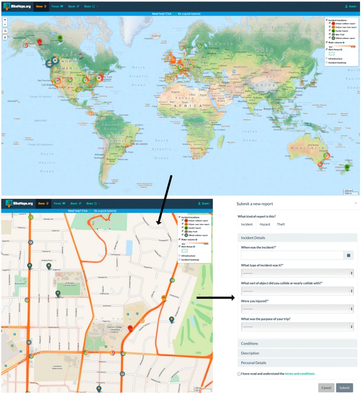
There are many public health benefits to cycling, such as chronic disease reduction and improved air quality. Real and perceived concerns about safety are primary barriers to new ridership. Due to limited forums for official reporting of cycling incidents, lack of comprehensive data is limiting our ability to study cycling safety and conduct surveillance. Our goal is to introduce BikeMaps.org, a new website developed by the authors for crowd-source mapping of cycling collisions and near misses. BikeMaps.org is a global mapping system that allows citizens to map locations of cycling incidents and report on the nature of the event. Attributes collected are designed for spatial modeling research on predictors of safety and risk, and to aid surveillance and planning. Released in October 2014, within 2 months the website had more than 14,000 visitors and mapping in 14 countries. Collisions represent 38% of reports (134/356) and near misses 62% (222/356). In our pilot city, Victoria, Canada, citizens mapped data equivalent to about 1 year of official cycling collision reports within 2 months via BikeMaps.org. Using report completeness as an indicator, early reports indicate that data are of high quality with 50% being fully attributed and another 10% having only one missing attribute. We are advancing this technology, with the development of a mobile App, improved data visualization, real-time altering of hazard reports, and automated open-source tools for data sharing. Researchers and citizens interested in utilizing the BikeMaps.org technology can get involved by encouraging citizen mapping in their region.
骑自行车有许多公共卫生益处,例如减少慢性病和改善空气质量。对安全的实际和感知到的担忧是阻碍新骑行者的主要障碍。由于缺乏官方报告骑行事故的论坛,缺乏全面的数据限制了我们研究骑行安全和进行监测的能力。我们的目标是介绍 BikeMaps.org,这是一个由作者为众包绘制骑行碰撞和险些碰撞地点而开发的新网站。BikeMaps.org 是一个全球地图系统,允许市民绘制骑行事故地点,并报告事件的性质。收集的属性旨在进行空间建模研究,以预测安全和风险因素,并协助监测和规划。该网站于 2014 年 10 月发布,在 2 个月内,该网站的访问量超过 14000 次,在 14 个国家进行了绘制。碰撞占报告的 38%(134/356),险些碰撞占 62%(222/356)。在我们的试点城市加拿大维多利亚,市民在 2 个月内通过 BikeMaps.org 绘制了相当于大约 1 年的官方骑行碰撞报告的数据。通过报告完整性作为指标,早期报告表明数据质量很高,其中 50%的报告完全归因,另外 10%的报告只有一个缺失属性。我们正在通过开发移动应用程序、改进数据可视化、实时更改危险报告以及自动化开源数据共享工具来推进这项技术。对使用 BikeMaps.org 技术感兴趣的研究人员和市民可以通过鼓励市民在他们所在地区进行地图绘制来参与其中。